Status of monument -> National monument
Pursuant to Article V para. 4 Annex 8 of the General Framework Agreement for Peace in Bosnia and Herzegovina and Article 39 para. 1 of the Rules of Procedure of the Commission to Preserve National Monuments, at a session held from 1 to 7 July 2003 the Commission adopted a
D E C I S I O N
I
The architectural ensemble of the old Jezersko fort in Jezersko, Municipality Bosanska Krupa, is hereby designated as a National Monument of Bosnia and Herzegovina (hereinafter: the National Monument).
The National Monument is located on cadastral plots 2472/1, 2472/2 and 2472/3, cadastral municipality Jezersko, Municipality Bosanska Krupna, Federation of BiH, Bosnia and Herzegovina.
The provisions relating to protection and rehabilitation measures set forth by the Law on the Implementation of the Decisions of the Commission to Preserve National Monuments, established pursuant to Annex 8 of the General Framework Agreement for Peace in Bosnia and Herzegovina (Official Gazette of the Federation of BiH nos. 2/02 and 27/02) shall apply to the National Monument.
II
The Government of the Federation of Bosnia and Herzegovina (hereinafter: the Government of the Federation) shall be responsible for ensuring and providing the legal, scientific, technical, administrative and financial measures necessary to protect, conserve, display and rehabilitate the National Monument.
The Government of the Federation shall be responsible for providing the resources for drawing up and implementing the necessary technical documentation for the rehabilitation of the National Monument.
The Commission to Preserve National Monuments of Bosnia and Herzegovina (hereinafter: the Commission) shall determine the technical requirements and secure the funds for preparing and setting up signboards with the basic data on the monument and the Decision to proclaim the property a National Monument.
III
For the purpose of the lasting preservation of the National Monument the following protection zones are hereby defined:
Protection Zone I comprises the area specified in Clause I para 2 of this Decision, and consists of the old Jezersko fort and the mosque within the ramparts.
Ÿ all works are prohibited other than conservation and restoration works on the old fort and works for the rehabilitation of the mosque, including works designed to display the monument, carried out to a design project approved by the relevant Federal Ministry and under the expert supervision of the heritage protection authority of FBiH (hereinafter: the heritage protection authority),
Ÿ the construction of all buildings or the erection of temporary or permanent structures unless for the sole purpose of the preservation and display of the monument are prohibited,
Ÿ the site of the monument shall be open and accessible to the public and may be used for educational and cultural purposes.
The following measures in particular shall be implemented:
Old Jezersko fort:
Ÿ clear the walls of vegetation representing a danger to the structure of the monument
Ÿ conservation of the existing state of the ramparts and towers of the old fort.
The rehabilitation of the mosque must be carried out to the following conditions:
Ÿ clear the interior of the mosque building
Ÿ carry out structural repairs and consolidation of damaged walls
Ÿ restore the entrance part of the mosque to its original use and appearance with a semi-enclosed portico with pillars
Ÿ reconstruct the šiše of the ceiling on the basis of the surviving remains of the šiše inside the mosque
Ÿ wherever windows and doors are missing from apertures, replace with appropriate windows and doors made on the model of the surviving windows and doors
Ÿ replace the existing roof cladding of curved tiles with the original cladding of wooden shingles
Ÿ replace damaged parts of the roof and ceiling structure and floors with new ones
Ÿ use the same or same type of materials as those of which the mosque is built and use the same building techniques and treatment of materials.
Protection Zone II consists of the area defined as c.p. 2469, 2470, 2473/2, 2475, 3723, constituting the plots immediately surrounding the fort and on the first steep slopes surrounding it some 25 m below the fort.
In this zone the rehabilitation and adaptation of existing buildings shall be permitted on condition that they are of a maximum of ground floor and one upper storey (6.5 m in height to the roof cornice) with maximum dimensions of 12 x 10 and pitched roofs of no less than 40 deg.
Detailed regional planning and town planning conditions for the construction of buildings in this zone must have the approval of the heritage protection authority.
No construction shall be permitted immediately alongside the south-western part of the fort on the plateau by the ramparts (plot 2473/2).
The construction of industrial buildings and facilities, major infrastructure, and potential polluters as defined by regulations, is prohibited.
IV
All executive and area development planning acts not in accordance with the provisions of this Decision are to be revoked.
V
Everyone, and in particular the competent authorities of the Federation of Bosnia and Herzegovina, the Canton, and urban and municipal authorities, shall refrain from any action that might damage the National Monument specified in Clause I of this Decision or jeopardize the preservation and rehabilitation thereof.
VI
The Government of the Federation, the Federal Ministry of Regional Planning and the Environment, the Federation heritage protection authority, and the Municipal Authorities in charge of urban planning and land registry affairs, shall be notified of this Decision in order to carry out the measures stipulated in Articles II-V of this Decision, and the Authorized Municipal Court shall be notified for the purposes of registration in the Land Register.
VII
The elucidation and accompanying documentation form an integral part of this Decision, which may be viewed by interested parties on the premises or by accessing the website of the Commission (http://www.aneks8komisija.com.ba)
VIII
Pursuant to Art. V para 4 Annex 8 of the General Framework Agreement for Peace in Bosnia and Herzegovina, decisions of the Commission are final.
IX
This Decision shall enter into force on the date of its adoption and shall be published in the Official Gazette of BiH and the Official Gazette of the Federation of BiH.
This Decision has been adopted by the following members of the Commission: Zeynep Ahunbay, Amra Hadžimuhamedović, Dubravko Lovrenović, Ljiljana Ševo and Tina Wik.
Chairman of the Commission
Amra Hadžimuhamedović
No.: 06-6-891/03-3
2 July 2003
Sarajevo
E l u c i d a t i o n
I – INTRODUCTION
Pursuant to Article 2, paragraph 1 of the Law on the Implementation of the Decisions of the Commission to Preserve National Monuments, established pursuant to Annex 8 of the General Framework Agreement for Peace in Bosnia and Herzegovina, a “National Monument” is an item of public property proclaimed by the Commission to Preserve National Monuments to be a National Monument pursuant to Articles V and VI of Annex 8 of the General Framework Agreement for Peace in Bosnia and Herzegovina and property entered on the Provisional List of National Monuments of Bosnia and Herzegovina (Official Gazette of BiH no. 33/02) until the Commission reaches a final decision on its status, as to which there is no time limit and regardless of whether a petition for the property in question has been submitted or not.
On 2 November 2002 the Assembly of Jezerski Ward submitted a petition for the designation of the old Jezersko fort as a National Monument of Bosnia and Herzegovina.
Pursuant to the provisions of the law, the Commission proceeded to carry out the procedure for reaching a final decision to designate the Property as a National Monument, pursuant to Article V of Annex 8 and Article 35 of the Rules of Procedure of the Commission to Preserve National Monuments.
II – PROCEDURE PRIOR TO DECISION
In the procedure preceding the adoption of a final decision to proclaim the property a national monument, the following documentation was inspected:
Ÿ Documentation on the location and current owner and user of the property (copy of cadastral plan and copy of land registry entry)
Ÿ Data on the current condition and use of the property, including a description and photographs, data of war damage if any, data on restoration or other works on the property if any, etc.
Ÿ Historical, architectural and other documentary material on the property, as set out in the bibliography forming part of this Decision.
The findings based on the review of the above documentation and the condition of the site are as follows:
1. Details of the site
Location
The old Jezersko fort stands on c.p. 2472/1, 2472/2, 2472/3, Land Registry entry no. 840, p.1, c.m.. Jezersko; and is in the following ownership: c.p. 2472/1, Islamic religious community of Jezersko, and c.p. 2472/2, 2472/3, Hilmija Crnkić.
The Jezersko fort is in a somewhat hilly area, criss-crossed by mountain rivers and streams. It stands at the end of an elongated slope. Immediately behind the fort the slope drops steeply into the valley in which the settlement of Jezersko lies.
Historical information
There is little historical data about the Jezersko fort.
Ÿ 1248 (Kreševljaković, 1953, 35).
Ÿ After this it no longer appears in any documents until the sixteenth century, when it is reported as being located in Zagreb county (Lopašić, 1943, 144, note. 267).
Ÿ From a document dating from 1549 the names of the nobles living in Jezerski are known (Lopašić, 1943, note 268). Jezersko fort seems to have been the fort of a peasant community until the sixteenth century, and that it was not until the mid sixteenth century that Nemčić nobles known as Jezerski i Svičovići managed to acquire it.
Ÿ Until 1563 the fort was in the possession of the Nemčić family.
Ÿ In 1576 the Ottomans occupied Cazin, Bužim and Jezerski.
Ÿ The Ottomans reinforced Jezersko fort with an outer curtain wall. The garrison of the fort was commanded by a dizdar.
Ÿ In 1687 Croatian borderers set Jezersko fort and Stina fort on fire.
Ÿ Documents record that in 1730 the dizdar was Mehmedaga.
Ÿ An official inventory in 1833 recorded that the fort had two cannon, and an Austrian report in 1834 that it had four.
The fort belonged to the Krupa kapetanija, and was abandoned in 1838.
2. Description of the monument
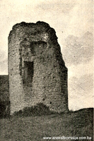
The Jezersko mediaeval fort is one of the simplest and smallest forts in Pounje (the Una river basin). Within the later Ottoman perimeter ramparts are the remains of a small mediaeval fort. The easiest access to the fort was from the south, where the gates to the Ottoman fort stand. The mediaeval Jezersko fort had a projecting round tower at the south-eastern angle of the bailey, with vertical walls, finely faced outside and in. On the outer, projecting facing of the tower, at a height of 1.4m above the foundations, is a decorative band. The external diameter of the tower is 8 m, and the walls are 1.8 m. thick. They still stand to a point above the third storey. Approximately one third is embedded in the bailey walls. It had at least three storeys – ground, first and second floors, as indicated by the holes into which the beams separating the storeys were fitted. In the north-western part of the tower, between two bailey walls, is a door at a height of 4 m. Inside the tower it can be seen that this entrance was to the second floor. Immediately below the door is a row of holes into which the wooden beams of the floor between the lower and upper levels of the tower were fitted. Above the door is another row of holes, probably part of a fourth storey of the tower or of the roof structure. There are no windows in the part of the tower that still stands, but only two artillery apertures to the left and right of the door, and one loophole on the first floor immeidately above the remains of the southern bailey wall.
Alongside the tower is a small square bailey with sides measuring about 14 m in length. Three sections of the bailey wall survive: the south wall alongside the tower, for a length of 3.7 m, part of the west wall for a length of 7 m and a height of 1.5 m, and a small part of the wall to the north-east of the tower. There was a loophole in the remains of the southern bailey wall, about 3 m high, facing south. To the north the bailey wall has been demolished and the concrete foundations for a cattleshed were laid on it but the shed was never completed. Truhelka says that the bailey wall was 7 m high, which is hard to say today, particularly because of the loopholes in the tower, immediately above the wall at a height of about 3 m. Truhelka says that the bailey wall was full of small narrow loopholes, and it appears that a hundred or so years ago the fort was in a much better state of preservation (Truhelka, 1904, 42).
It is hard to determine where the entrance to the bailey and fort was, but it certainly was not in the southern bailey wall by the tower, as Truhelka assumed (1904, 41) since that part of the wall is on bedrock. In this case it is simply an artificial hole in the wall (Truhelka, 1904, 42).
It is not known when the fort was built. Like the fort in Velika Kladuša and that in Podzvizd, it appears archaic. Although, like Bužim, it is referred to in historical sources in the twelfth century, based on its surviving appearance it could be more recent (Popović, 1995, 42). Many features are similar to parts of the inner fortifications of the mediaeval fort of Bužim (similar building techniques and shape of tower, arrangement of the floors in the towers, shapes of loopholes and artillery openings).
It is a local tradition that the outer ramparts were built by the Ottomans, a fact that is also quoted by every other author (Lopašić 1943, 145; Truhelka, 1904, 42; Kreševljaković, 1953, 35). The Ottoman-period ramparts cover an area measuring 55 x 20 m, with the long axis along the north-west/south-east lie of the land. On the inside, the ramparts are in a very ruinous state, surviving in places to a height of barely a metre, while as a whole the outer walls survive to the level of the inside of the fort, serving as a retaining wall surrounding the terrain of the inner fort following the slope. At the top of the slope, where the entrance to the fort is (at third of the way along the south-eastern part of the fort) the above-ground walls are still standing to a height of 2 to 3 m. Three features stand out in the curtain wall: the way they follow the slope, but with the line of the walls broken under the influence of the development of firearms, albeit with very wide angles. In the south-east wall of the town there is a gate with an opening 2.85 m wide, projecting about 1 m from the curtain wall. The gate is not in the centre of the wall but about 10 m from the south-western angle of the fort and about 17 m from the south-eastern angle. The gate is in a projecting part of the front wall. About a hundred years ago it was still almost intact, but all that remains now is the projecting walls. A cobbled path leads from the entrance towards the mosque. On the north side of t he wall, at the point where it projects furthest, is a large round-arched aperture, but it is impossible to say whether it was for a large window or a small door. Since the terrain is inaccessible, its finely carved frame survives. It is obvious that there were premises of some kind in the northern part of the fort, which only archaeological excavations could reveal.
Within the Ottoman ramparts are a mosque and an old building.
Mosque
Written sources have revealed no exact date when the mosque was built but, by comparing it with typologically similar mosques in the Krajina and the appearance and treatment of the wooden elements of the interior, it may be assumed to date from the nineteenth century.
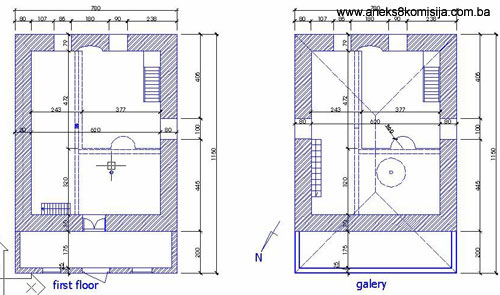
The mosque building has a rectangular ground plan with exterior dimensions of some 7.80 x 9.50 m plus 2 x 7.80 m for the portico, and overall usable space of about 94 sq.m. (49 sq.m. ground floor plus 32 sq.m. mahfil plus 13 sq.m. portico). The mosque is stone-built with the walls plastered and whitewashed inside and out.
Together with the wooden mosques in Krasulja near Ključ, and the Hatinac mosque in Bihać, this mosque is arranged with the mahfil set along two walls. In all these mosques the front mahfil does not extend to half the prayer space. By comparison with the last two mosques, the mosque in the Jezersko fort has a wide lateral mahfil.
In the treatment of the entrance area of the portico the concept of a half-enclosed entrance portico is recognizable, characterized by the lower part of the entrance area with a solid wall and the upper part treated as a portico with pillars. There is a similar portico in the mosque in Todorovo (this mosque is on the road from Pećigrad to Vrnograč and was built in 1868). Such porticoes were typical of the Krajina but from the late nineteenth century on they were often walled in and turned into enclosed porticoes, or an exterior mahfil built into them (Bećirbegović, 1999, pp. 138 and 168). In the case of the mosque within the Jezersko fort, planks and wooden boards have been fitted over the pillars of the portico.
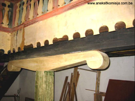
The weight of the mahfil floor is borne by a robust wooden pillar some 20 x 20 cm in cross-section set beneath the lateral mahfil across a wooden joist some 20 x 25 cm in cross-section let into the mihrab south-eastern wall and the entrance, south-western wall and over a wooden headtree with a cross-section of some 20 x 25 cm which has projecting brackets reaching a length of about 100cm. On this main joist of the side mahfil, set vertically to the mihrab wall, is the frontal wooden joist of the front mahfil. The corbel of the load-bearing pillar is moulded so that the cross-section of the wooden beam narrows towards the ends of the brackets, which terminate in scrolls.
Access to the mosque is from the north-west, through a two-storey-high entrance portico which, together with the enclosed area of the mosque, is set beneath a single hipped roof.
The prayer space at ground floor level has an area of about 49 sq.m., significantly increased by the mahfil along two walls. The front part of the mahfil is about 3.20 m deep and the lateral part is about 2.45 m wide, making a usable mahfil area of about 32 sq.m. and increasing the total usable area of the interior of the mosque to about 94 sq.m. The use of such a mahfil together with the ground plan of the central area significantly increased the usable space and thus the number of worshippers the mosque could hold at prayer time, which was the result of the specific political, economic and military circumstances that prevailed in western Bosnia in the seventeenth and eighteenth centuries (Bećirbegović, 1999, pp. 58-63 and 127-129).
The mahfil was reached by a single-flight wooden staircase set against the wall to the left of the entrance door in the centre of the south-west wall. In the central part of the front mahfil is a semi-circular projection for the muezzin.
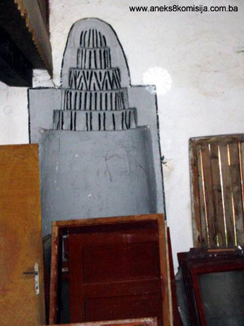
The mihrab, measuring about 120 cm in width and 340 cm in height, in the form of an elliptical niche, is set in the south-east wall and has no frame. The upper part of the mihrab niche is decorated with five horizontal bands with linear and triangular motifs emphasized by colour and shallow moulding.
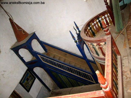
To the right of the mihrab is the wooden mimber. The entrance opening is round-arched terminating in wavy moulding and a crescent moon motif. The side railing of the steps and the sides of the mimber are moulded and decorated with geometric motifs of stars and waves. Above the mimber podium is a canopy on four pillars terminating in a round arch. The bowl of the mimber is polygonal and terminates in an octagon. The mimber is adorned with polychrome painted decorations.
The balustrade of the wooden mahfil railing is moulded and painted, as is the lower decorative frieze with arch motifs carved into the frontal boards of the mahfil.
The mosque has two rows of rectangular windows. On the entrance facade there are two lower windows, on the south-west facade one lower and one upper, on the south-east facade two upper and two lower, and on the north-east facace one upper window.
On the south-east façade there are four lower windows and two upper, while on the entrance face there are two upper windows only, above the portico roof. The upper and lower windows are not placed vertically in line. The windows are double sash, glazed with ordinary glass. The lower row of windows on the south-eastern façade is fitted with iron bars.
The mosque has a steep hipped roof with the wooden minaret emerging from the centre. The pitch of the roof is almost 40 deg. There is no flashing or guttering.
The roof structure is of wood, with double curved tile cladding. The originally cladding was of shingles, which the tiles replaced. The structural treatment of the roof is a combination of kingposts and struts.
The loft space is reached from the mahfil by a single flight of wooden ladder-style steps against the north-east wall. The minaret is reached from the central loft area by a spiral staircase leading to the so-called open gallery of the šerefe. The central wooden mast is made of an oak log with a basal cross-section of almost 18 x 18 cm, narrowing towards the base to about 16 x 16 cm and passing for its full length through the mahfil floor and the mosque ground floor, wholly visible in the interior of the mosque.
The minaret consists of eight wooden edging pillars bevelled on the outside, and gradually narrowing in cross-section from the base to the top of the minaret. The vertical structure of the minaret rests on a wooden grid base.
Some 30 to 40 years ago the outside of the minaret was completely faced with galvanized iron sheeting.
As a result of hostilities, the mosque took a direct hit from a shell in the upper part of the south-east wall, which together with damage to the roof cladding led to the collapse of the šiše ceiling of the mosque. The ceiling was protected by an improvised cladding of wooden boards and plastic sheeting attached by laths to this temporary structure to protect the mosque from further deterioration.
Alongside the mosque is a single nišan with inscription, recording that a certain Bekir Mahmutović was buried there (Mujezinović M., 1998, p.88).
Alongside the fence around the burial ground, to the right of the entrance to the mosque portico, are two so-called hajji stones (hadžin-taš). It is not known how old the tradition is of setting hajji stones, since there is no record of it in religious or historical documents. Surviving witnesses of the last hadžin taš’s say that these stones were places from which hajjis set off on the hajj or pilgrimage, bidding farewell to their loved ones and asking forgiveness of them and the other members of the congregation, relativeds and neighbours. After praying two rakaats (cycles of formal prayer) in the mosque, the hajji and his closest relatives would go to the taš-stone, climb on it, recite a’udhu, the basmala, rabi yassir, give thanks to Allah, recite salawat to the Prophet and give a speech, asking forgiveness of all those present, showering the children with sweets and small change, give gifts to the hojja, and authorize his wife in his absence to manage his property from home (Hadžić Nijaz, Medžlis Bužim (1579-1999). džemati, džamije, imami, Bužim, BZK Preporod, 2000, p. 279).
A building that was lived in stands in the south-eastern angle of the fort right by the entrance. It measures 7.8 x 7.9 m, and is built of the same materials as the mosque.
Two buildings alongside the eastern rampart, indicated by Truhelka in his plan of the fort, no longer exist (Truhelka, 1904, p.. 42).
Legal status to date
Pursuant to the law, and by Ruling of the Institute for the Protection of Cultural Monuments of SR BiH no. 199/51 dated 18 April 1941, the Jezersko fort was placed under state protection.
By Ruling of the Institute for the Protection of Cultural Monuments of SR BiH no. 02-843-3 dated 18 April 1962 the building was entered in the Register of immovable cultural monuments under serial no. 248.
The Regional Plan of the Republic of Bosnia and Herzegovina to 2002 listed the monument as a Category II monument.
3. Research and conservation and restoration works
None.
4. Current condition of the site
By comparison with photographs taken more than 100 years ago, the upper part of the mediaeval tower has deteriorated badly. Holes have been dug at the base and stone removed from the wall revetment. The upper courses of stone of the tower tend to suffer further damage. The bailey wall has been pulled down, clearly by the local population, and further damaged by the construction of concrete foundations at one point.
The top of the Ottoman period ramparts is accessible at some points from the inner side, and is also in a somewhat ruinous state.
The frontal wall of the gate has collapsed completely.
The mosque building is in a very bad state and has not been used since 1992 (when a new mosque was built in Jezersko).
Signs of shelling during the 1992-1995 war in Bosnia and Herzegovina are visible on the mosque.
III - CONCLUSION
Applying the Criteria for the adoption of a decision on proclaiming an item of property a national monument, adopted at the fourth session of the Commission to Preserve National Monuments (3 to 9 September 2002), the Commission has enacted the Decision cited above.
The Decision was based on the following criteria:
A. Time frame
B. Historical value
D. Clarity
D.ii. evidence of historical change
D. iv. evidence of a particular type, style or regional manner
D. v. evidence of a typical way of life at a specific period
F. Townscape/landscape value
F.i. relation to other elements of the site
F.ii. meaning in the townscape
G. Authenticity
G.iv. traditions and techniques
G.v. location and setting
H. Rarity and representativity
H.i. unique or rare example of a certain type or style
The following documents form an integral part of this Decision:
- Copy of cadastral plan
- Copy of land register entry and proof of title;
- Photodocumentation;
- Drawings
Bibliography:
During the procedure to designate the monument as a national monument of Bosnia and Herzegovina the following works were consulted:
Kreševljaković, Hamdija, Prilozi povijesti bosanskih gradova pod turskom upravom. (Papers on the history of Bosnian towns/forts under Turkish rule) Papers on Oriental Philology and the History of the Yugoslav Peoples under Turkish Rule no. II, Sarajevo, 1952
Kreševljaković, Hamdija, Stari bosanski gradovi. (Old Bosnian forts/towns) Naše starine I, Institute for the Protection of Cultural Monuments of BiH, Sarajevo, 1954, 22.
Popović, Marko, Srednjovjekovne tvrđave u Bosni i Hercegovini. (Mediaeval forts in BiH) Papers for the History of BiH 1, Serbian Academy of Science and the Arts, Belgrade, 1995, 33-55.
Truhelka, Ćiro, Naši gradovi. (Our forts) J. Studnički and co booksellers, Sarajevo, 1904
Vego, Marko, Naselja srednjovjekovne bosanske države. (Settlements of the mediaeval Bosnian state ), Svjetlost, Sarajevo 1957, 105
|