Status of monument -> National monument
Pursuant to Article V para. 4 Annex 8 of the General Framework Agreement for Peace in Bosnia and Herzegovina and Article 39 para. 1 of the Rules of Procedure of the Commission to Preserve National Monuments, at a session held on 11 March 2011 the Commission adopted a
D E C I S I O N
I
The historic site of the necropolis with stećak tombstones at Zlatarić in Ledići, Municipality Trnovo, is hereby designated as a National Monument of Bosnia and Herzegovina (hereinafter: the National Monument).
The National Monument consists of the necropolis with 73 stećak tombstones.
The National Monument is located on a site consisting of part of cadastral plot no. 412 and c.p. no. 413, title deed no. 184, Land Register entry no. 184, c.p. no. 414 and part of c.p. no. 430, title deed no. 33, Land Register entry no. 33, part of c.p. no. 431, title deed no. 218, Land Register entry no. 218, part of c.p. no. 432, title deed no. 81, Land Register entry no. 81, cadastral municipality Ledići, Municipality Trnovo, Federation of Bosnia and Herzegovina, Bosnia and Herzegovina.
The provisions relating to protection measures set forth by the Law on the Implementation of the Decisions of the Commission to Preserve National Monuments, established pursuant to Annex 8 of the General Framework Agreement for Peace in Bosnia and Herzegovina (Official Gazette of the Federation of BiH nos. 2/02, 27/02, 6/04 and 51/07) shall apply to the National Monument.
II
The Government of the Federation of Bosnia and Herzegovina (hereinafter: the Government of the Federation) shall be responsible for providing the legal, scientific, technical, administrative and financial measures necessary for the protection, conservation and presentation of the National Monument.
The Commission to Preserve National Monuments (hereinafter: the Commission) shall determine the technical requirements and secure the funds for preparing and setting up signboards with basic details of the monument and the Decision to proclaim the property a National Monument.
III
To ensure the on-going protection of the National Monument on the site defined in Clause 1 para. 3 of this Decision, the following protection measures are hereby stipulated:
- all works are prohibited other than investigative and conservation-restoration works, routine maintenance works, and works designed to present the monument, with the approval of the Federal ministry responsible for regional planning and under the expert supervision of the heritage protection authority of the Federation of Bosnia and Herzegovina (hereinafter: the heritage protection authority);
- the site of the monument shall be open and accessible to the public, and may be used for educational and cultural purposes;
- the refurbishment of the necropolis and repairs to any damage are permitted solely subject to first drawing up a plan for repairs, restoration and conservation and to the approval of the relevant, and under the expert supervision of the heritage protection authority;
- the removal of lichen and moss from the stećaks is prohibited;
- by way of exception to the above provision, the stećaks may be cleaned if required to examine the epigraphic or decorative features of a stećak, subject to first compiling a report and obtaining the approval of the entity ministry responsible for regional planning. The report should be based on such biological, chemical, physical and other analyses as a conservator considers necessary, and should include appropriate conservation measures and an assessment of the impact of cleaning methods on the stone;
- the area is an archaeological site, and investigative works must therefore be carried out in the presence of an archaeologist;
- the area is a potential archaeological site, and investigative works must therefore be carried out in the presence of an archaeologist;
- the dumping of waste is prohibited.
The Government of the Federation shall be responsible for implementing emergency protection measures to prevent further damage to the tombstones by erecting a wooden fence along the boundaries of the protected zone. The permitted height of the fence is 150 cm. The programme of emergency protection measures shall cover:
- the production of a preliminary survey of the state of the property to identify the type and degree of risk to the site and damage to the tombstones;
- archaeological investigations to a programme drawn up in advance;
- clearing the site, making good damage to the tombstones and restoring overturned stećaks to their original position;
- relocating the roads that run across the stećaks and that are being used by the drivers of off-road vehicles;
- making good the footpath leading to the site with the stećaks.
A buffer zone is hereby prescribed with a width of 100 m from the boundaries of the National Monument. The following measures shall apply within this zone:
- works that could in any way be detrimental to the zone or have the effect of altering the site are prohibited;
- infrastructure works are prohibited except with the approval of the relevant ministry and the expert opinion of the heritage protection authority;
- the dumping of waste is prohibited.
The Government of the Federation of Bosnia and Herzegovina shall be responsible in particular for ensuring that the following measures are carried out:
- conducting a geodetic survey of the site;
- drawing up a plan for the repair, restoration, conservation and presentation of the National Monument;
- drawing up a Management Plan.
IV
All movable artefacts found during the course of the archaeological survey shall be deposited in the nearest museum able to provide the necessary personnel, material and technical conditions or in the National Museum of Bosnia and Herzegovina in Sarajevo, processed, and suitably presented.
All movable and immovable archaeological material found during the course of the archaeological investigations shall be professionally analyzed.
Upon completion of the archaeological works the archaeologist in charge of the investigations shall submit a report to the Commission and to the institution that conducted the investigations.
The archaeologist leading the investigations must have access to all the movable and immovable archaeological material found during the course of the investigations and until his/her report is completed, for a period not exceeding three years.
All immovable finds shall be conserved in situ as the archaeological investigations proceed, and the movable archaeological material shall be conserved and placed for safe keeping in a suitable storage facility.
Upon receipt of a report on the investigations conducted, the Commission shall identify which movable artefacts shall be subject to protection measures to be determined by the Commission.
The removal of the movable artefacts referred to in para. 1 above from Bosnia and Herzegovina is prohibited.
By way of exception to the provisions of paragraph 7 of this Clause, if the leader of the investigations determines that a given archaeological artefact must be processed abroad, and provides evidence to that effect to the Commission, the Commission may permit the temporary removal of the artefact from the country subject to detailed conditions for its export, treatment while out of the country and return to Bosnia and Herzegovina.
V
All executive and area development planning acts are hereby revoked to the extent that they are not in accordance with the provisions of this Decision.
VI
Everyone, and in particular the competent authorities of the Federation of Bosnia and Herzegovina, the Canton, and urban and municipal authorities, shall refrain from any action that might damage the National Monument or jeopardize the preservation thereof.
VII
The Government of the Federation, the Federal Ministry responsible for regional planning, the heritage protection authority, and the Municipal Authorities in charge of urban planning and land registry affairs, shall be notified of this Decision in order to carry out the measures stipulated in Articles II to VI of this Decision, and the Authorized Municipal Court shall be notified for the purposes of registration in the Land Register.
VIII
The elucidation and accompanying documentation form an integral part of this Decision, which may be viewed by interested parties on the premises or by accessing the website of the Commission (http://www.kons.gov.ba).
IX
Pursuant to Art. V para 4 Annex 8 of the General Framework Agreement for Peace in Bosnia and Herzegovina, decisions of the Commission are final.
X
This Decision shall enter into force on the day following its publication in the Official Gazette of BiH.
This Decision has been adopted by the following members of the Commission: Zeynep Ahunbay, Martin Cherry, Amra Hadžimuhamedović, Dubravko Lovrenović and Ljiljana Ševo.
No: 05.2-2.3-77/11-4
11 March 2011
Sarajevo
Chair of the Commission
Amra Hadžimuhamedović
E l u c i d a t i o n
I – INTRODUCTION
Pursuant to Article 2, paragraph 1 of the Law on the Implementation of the Decisions of the Commission to Preserve National Monuments, established pursuant to Annex 8 of the General Framework Agreement for Peace in Bosnia and Herzegovina, a “National Monument” is an item of public property proclaimed by the Commission to Preserve National Monuments to be a National Monument pursuant to Articles V and VI of Annex 8 of the General Framework Agreement for Peace in Bosnia and Herzegovina and property entered on the Provisional List of National Monuments of Bosnia and Herzegovina (Official Gazette of BiH no. 33/02) until the Commission reaches a final decision on its status, as to which there is no time limit and regardless of whether a petition for the property in question has been submitted or not.
On 5 February 2009, Hamzalija Trako of Sarajevo submitted a proposal to designate the necropolis of stećak tombstones at two sites (by the road to the village of Dujmoviće and on Zlatarić hill) in the village of Ledići, Trnovo Municipality, as a national monument of Bosnia and Herzegovina.
Pursuant to the provisions of the law, the Commission proceeded to carry out the procedure for reaching a final decision to designate the Property as a National Monument, pursuant to Article V para. 4 of Annex 8 and Article 35 of the Rules of Procedure of the Commission to Preserve National Monuments.
Statement of Significance
The mediaeval tombstones known as stećci (pl. of stećak) are unique to Bosnia and Herzegovina and its neighbours. They provide impressive evidence of the growing economic power of Bosnian feudal society in the 14th century, the opening of mines, increasing urbanization, and the wish of individuals to display their status and power through the appearance of their tombstones.
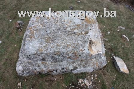
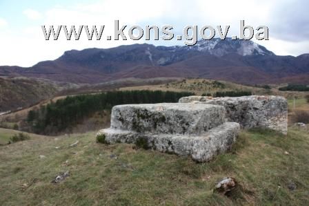
The stećci at Zlatarić are recumbent tombstones of two kinds: chest-shaped and gabled or sarcophagus-like.The number of tombstones suggests that the necropolis belonged to the wider community of the area. Two of them, located on a slight elevation in the south-west part of the necropolis, stand apart. The artistic quality of the tombstones lies in their high-relief decoration. Three chests are decorated with ordinary or stylized crosses; the remaining 70 tombstones are undecorated.
II – PRELIMINARY PROCEDURE
In the procedure preceding the adoption of a final decision to proclaim the property a national monument, the following documentation was inspected:
- details of the current condition and use of the property, including a description, architectural survey and photographs
- an inspection of the current condition of the property
- a copy of the cadastral plan
- a copy of the Land Register entry
- historical, architectural and other documentary material on the property, as set out in the bibliography forming part of this Decision
Pursuant to Article V para. 2 of Annex 8 of the General Framework Agreement for Peace in Bosnia and Herzegovina and Article 37 of the Rules of Procedure of the Commission, before rendering a final decision designating a property as a national monument, the Commission is required to provide the owner of the proposed monument, the person submitting the petition, the institutions responsible for heritage, professional and academic institutions, experts and scholars, as well as other interested parties, to express their views. Accordingly, the Commission sent a letter ref. 02-35-23/09-124 dated 7 August 2009 requesting documentation and views on the designation of the necropolis with stećak tombstones at Zlatarić, Trnovo Municipality, was sent to Trnovo Municipality (Mayor), department responsible for urbanism and cadastral affairs, the Federal Ministry of Regional Planning and the Institute for the Protection of Monuments of the Federal Ministry of Culture and Sport.
The Commission also sent the following letters requesting information(1):
- Letter ref 02-36-9/09 of 19.08.2009 to the Municipal Court in Sarajevo requesting a copy of the Land Register entry;
- Letter ref 05.02-36.1-1/10-121 of 01.09.2010 to the Municipal Court in Sarajevo requesting a copy of the Land Register entries;
- Letters ref. 05.2-36.1-7/11-7 and 05.2-36.1-7/11-8 of 12.01.2011 to Trnovo Municipality and the Municipal Court in Sarajevo requesting Land Register entry and cadastral details.
In response, the Commission has received the following documentation:
- Land Register entry no. 33 and copy of cadastral plan for c.p. 414, c.m. Ledići, Trnovo, scaled 1:2500, issued on 12 August 2009 by the Department of Geodetics, Proprietary Rights, Cadastral Affairs and Urbanism Inspection Supervision of Trnovo Municipality (letter ref. 02/3-30-2394/09);
- Letter from the Land Registry office of the Municipal Court in Sarajevo ref. 065-0-Su-09-003077 of 20 August 2009 supplying Land Register entry for c.p. no. 414, c.m. Ledići;
- Letter from the Department of Geodetics, Proprietary Rights, Cadastral Affairs and Urbanism Inspection Supervision of Trnovo Municipality (letter ref.02/3-30-2458 of 2 September 2010 supplying cadastral details for c.p. 416, 418, 421, 422, 423, 426/2, 430, 431, c.m.Ledići;
- Letter from the Land Registry office of the Municipal Court in Sarajevo ref. 065-0-Rz-10-4068 of 6 September 2010 supplying Land Register entry for c.p. 416, 418, 421, 422, 423, 426/2, 430, 431, c.m.Ledići;
- Letter from the Department of Geodetics, Proprietary Rights, Cadastral Affairs and Urbanism Inspection Supervision of Trnovo Municipality (letter ref.02/3-30-87/10 of 13 January 2011 supplying cadastral details for c.p. 412, 413, 432, c.m.Ledići;
- Letter from the Land Registry office of the Municipal Court in Sarajevo ref. 065-0-Rz-11-158 of 17 January 2011 supplying Land Register entry for c.p. 412, 413, 432, c.m.Ledići;
- Letter ref. 03-23-2-1203/09 of 10 August 2009 from the Federal Ministry of Regional Planning notifying the Commission to Preserve National Monuments that it has no details or documentation relating to the necropolis with stećaks at Zlatarić in the village of Ledići, Trnovo Municipality;
- Letter ref. 07-40-4-3178-1/09 of 28 August 2009 from the Institute for the Protection of Monuments under the Federal Ministry of Culture and Sport supplying details of previous protection of the site at Ledići, Trnovo Municipality;
- The views of the owner have not been received.
The findings based on the review of the above documentation and the condition of the site are as follows:
1. Details of the property
Location
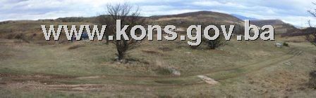
Ledići is at the northern foot of Mt Treskavica, 8 miles as the crow flies west of Trnovo. Two sites with stećci (pl. of stećak) have been recorded near the village: Kapova selišta (Borija) and Zlatarić. The necropolis with stećci at Zlatarić is at an altitude of 906 m, at 43°40'38.85"N 18°20'44.70"E(2).
The site of Zlatarić is bounded by the following coordinates:
Point 1: x=43.676969 y=18.345508;
Point 2: x=43.677136 y=18.346111;
Point 3: x=43.677602 y=18.346155;
Point 4: x=43.677625 y=18.345469;
Point 5: x=43.677266 y=18.345508;
Point 6: x=43.677075 y=18.345069;
The National Monument is located on a site consisting of part of cadastral plot no. 412 and c.p. no. 413, title deed no. 184, Land Register entry no. 184, c.p. no. 414 and part of c.p. no. 430, title deed no. 33, Land Register entry no. 33, part of c.p. no. 431, title deed no. 218, Land Register entry no. 218, part of c.p. no. 432, title deed no. 81, Land Register entry no. 81, cadastral municipality Ledići, Municipality Trnovo, Federation of Bosnia and Herzegovina, Bosnia and Herzegovina.
Plots c.p. 412 and 413 are jointly owned by Mulaosmanović (Bajro) Sejd, Mulaosmanović (Suada) Ajla and Mulaosmanović (Suada) Aldin, c.p. 414 and 430 are the property of Trnovo Municipality, c.p. 431 is the property of Simanić (Mlađen) Lazar, and c.p. 432 is jointly owned by Sućeska (Nusreta) Nusret, Ćiber (Nusret) Jasmina and Kezman (Salem) Edžnan.
Historical background
The župa (county) of Vrhbosna took shape in the Sarajevo and Visoko plains in mediaeval times, covering the region of the upper Bosna River and its tributaries the Miljacka, Željeznica and Zujevina(3), and bounded to the east by Mt Romanija, to the south-east by Mt Jahorina, to the south by Mt Treskavica and Mt Bjelašnica, to the west by Mt Igman and the Kobiljača pass, and to the north by the river and župa of Vogošća. Feudal holdings began to take shape as the early feudal counties broke up when they “no longer suited the late feudal concept of authority.” The county of Vrhbosna was not spared, and by the latter half of the 14th century it was split up into a number of smaller districts(4).
The county of Mokro-Glasinac, with which the Glasinac plain from the old Olovo county was merged, took shape in the Mokranjska-Miljacka valley, while the county of Pale was formed in the Pale Miljacka valley. These counties fell within the lands of the Pavlović family, as did neighbouring Prača.
Another part of the great county of Vrhbosna – the Zujevina valley (present-day Hadžići) – remained within the lands under the direct rule of the king of Bosnia, the contrata del re or Crown lands, while the area around the confluence of the Zujevina and the Bosna remained part of the county of Vrhbosna(5).
The upper River Željeznica valley, between Mts Treskavica and Bjelašnica on one side and Mt Jahorina on the other (the present-day Trnovo area), formed a separate territorial political entity, most of it marching with the lands of herceg Stjepan, into which it was finally absorbed in 1435/36(6).
2. Description of the property
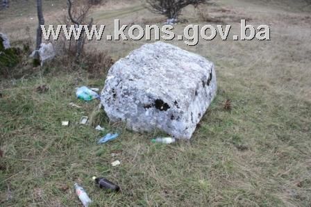
The stećci at Zlatarić are recumbent tombstones of two kinds: chest-shaped and gabled or sarcophagus-like. The number of tombstones suggests that the necropolis belonged to the wider community of the area. Two of them, located on a slight elevation in the south-west part of the necropolis, stand apart. The artistic quality of the tombstones lies in their high-relief decoration. Three chests (nos. 3, 40 and 71) are decorated with ordinary or stylized crosses; the remaining 70(7) tombstones are undecorated. Most of the stećci are lying north-south or west-east, with a few lying northwest-southeast or southwest-northeast. The roads to the south and west of the site are used by day-trippers and off-road and rally drivers, which poses a direct threat to the stećci day after day, exacerbated by the fact that the road on the south side of the necropolis runs over some of the tombstones. There have also been instances of vandalism, consisting of overturning or smashing the tombstones and of dumping large quantities of litter (glass and plastic bottles, tin cans and plastic bags).
Condition of the tombstones
Stećak no. 1. – chest, standing apart on a slight elevation at the southwest end of the necropolis, covered with lichen, chipped and cracked, lying west-east; the stećak measures 197x87x62 cm.
Stećak no. 2. – chest with plinth, standing apart on a slight elevation at the southwest end of the necropolis, covered with lichen, east end chipped, lying west-east; the stećak measures 126x100x31 cm; the plinth measures 157x133x20 cm.
Stećak no. 3. – chest, decorated, almost completely sunken into the ground leaving only the top visible at ground level, lying north-south. The road passing over the tombstone is now used by tourists and off-road and rally drivers. The top is decorated with a cross in high relief; the stećak measures 176 cm long x 77 cm wide.
Stećak no. 4. – chest, partly sunken, covered with moss and lichen, lying north-south, with the road passing over part of it to the south; the stećak measures 180x60x visible height 13 cm.
Stećak no. 5. – chest, partly sunken, covered with moss and lichen, lying west-east; the stećak measures 140x visible width 36 x visible height 10 cm.
Stećak no. 6. – chest, partly sunken, covered with moss and lichen, with a tree growing between this and the next (no. 7), which is undermining the stability and position of both tombstones, lying north-south; the stećak measures 160x60x visible height 12 cm.
Stećak no. 7. – chest, partly sunken, covered with moss and lichen, lying north-south; the stećak measures 170x67x visible height 17 cm.
Stećak no. 8. – chest, partly sunken, covered with moss and lichen, lying west-east; the stećak measures 170x70x visible height 8 cm.
Stećak no. 9. – chest, partly sunken, covered with moss and lichen, lying southwest-northeast; the stećak measures 135x40x12 cm.
Stećak no. 10. – chest, almost completely sunken into the ground leaving only the top visible at ground level, covered with lichen, lying west-east; the stećak measures 117 cm long x 78 cm wide.
Stećak no. 11. – chest, partly sunken, covered with lichen, lying west-east; the stećak measures 160x64x20 cm.
Stećak no. 12. – chest, partly sunken, covered with lichen and moss, lying west-east; the stećak measures 198x100x4 cm.
Stećak no. 13. – gabled, lying on its north side, covered with lichen, lying west-east; the stećak measures 183x64x107 cm.
Stećak no. 14. – gabled with plinth, lying on its south side and partly sunken, damaged plinth, covered with lichen and moss, lying west-east; the stećak measures 188 x visible width 45 x 114 cm; the plinth measures 209 x visible width 37 x 23 cm.
Stećak no. 15. – gabled, lying on its north side and partly sunken, covered with lichen and moss and with rubbish beside it (glass and plastic bottles, tin cans and plastic bags), lying west-east; the stećak measures 161x visible width 40 x 109 cm.
Stećak no. 16. – chest of poor quality stone, with the top degraded by exposure to the elements, covered with lichen and moss, lying north-south; the stećak measures 177x70x15 cm.
Stećak no. 17. – gabled, partly sunken, close to tall-growing plants undermining its stability, covered with lichen and moss, and with rubbish beside it (glass and plastic bottles, tin cans and plastic bags), lying north-south; the stećak measures 146x43x visible height 16 cm.
Stećak no. 18. – chest, almost completely sunken into the ground leaving only the top visible at ground level, lying north-south; the stećak measures 70 cm long x 40 cm wide.
Stećak no. 19. – chest, partly sunken, covered with moss and lichen, lying northwest-southeast; the stećak measures 165x56x10 cm.
Stećak no. 20. – chest, partly sunken, covered with moss and lichen, lying west-east; the stećak measures 182 cm long x71x visible height 6 cm.
Stećak no. 21. – chest, partly sunken, covered with moss and lichen, lying north-south; the stećak measures 153x61x visible height 14 cm.
Stećak no. 22. – chest, partly sunken, covered with moss and lichen, lying northwest-southeast; the stećak measures 153x61x visible height 5 cm.
Stećak no. 23. – chest, partly sunken, of poor quality stone, with the top degraded by exposure to the elements, covered with moss and lichen, lying west-east; the stećak measures 155x72x visible height 13 cm.
Stećak no. 24. – chest, partly sunken, close to a tall tree which is undermining its stability covered with moss and lichen, lying west-east; the stećak measures 170x80x visible height 24 cm.
Stećak no. 25. – chest, partly sunken, covered with moss and lichen, lying west-east; the stećak measures 199 x 80,5x 22 cm.
Stećak no. 26. – chest, partly sunken, covered with lichen, lying north-south; the stećak measures 171,5x76x55 cm.
Stećak no. 27. – chest, almost completely sunken and covered with humus, lying west-east; the stećak measures visible length 50 x visible width 30 cm.
Stećak no. 28. – chest, partly sunken and tilted towards the north, covered with lichen and moss, lying west-east; the stećak measures 178x92x72 cm.
Stećak no. 29. – chest, partly sunken, covered with lichen and moss, lying west-east; the stećak measures 160x74x34 cm.
Stećak no. 30. – chest, almost completely sunken into the ground leaving only the top visible at ground level, covered with moss and lichen, lying west-east; the stećak measures 170 cm long x 84 cm wide.
Stećak no. 31. – chest, decorated, partly sunken, close to a tree which is undermining its stability and that of tombstone no. 32, covered with moss and lichen, lying north-south; the stećak measures 196x87x41 cm.
An incised cross motif with semicircles instead of cross-arms features on the south end of the stećak.
Stećak no. 32. – chest, partly sunken, covered with moss and lichen, lying north-south; the stećak measures 170 x 84 x visible height 14 cm.
Stećak no. 33. – chest, partly sunken, covered with lichen, lying north-south; the stećak measures 173x77x visible height 8 cm.
Stećak no. 34. – chest completely sunken into the ground leaving only part the top visible, lying north-south; the stećak measures visible length 32 x visible width 50 cm.
Stećak no. 35. – chest completely sunken into the ground leaving only part the top visible, lying north-south; the stećak measures visible length 50 cm.
Stećak no. 36. – chest, partly sunken at the south-east end, covered with moss and lichen, lying northwest-southeast; the stećak measures 224x117x visible height 16 cm.
Stećak no. 37. – chest, almost completely sunken into the ground leaving only the top visible at ground level, covered with moss and lichen, lying west-east; the stećak measures 176 cm long x 110 cm wide.
Stećak no. 38. – chest, partly sunken, of poor quality stone, with the top degraded by exposure to the elements, lying west-east; the stećak measures 170x65x28 cm.
Stećak no. 39. – chest, partly sunken, of poor quality stone, with the top degraded by exposure to the elements, lying northwest-southeast; the stećak measures 160x82x23 cm.
Stećak no. 40. – chest, decorated, partly sunken, covered with lichen and moss, lying west-east; the stećak measures 170x80x14 cm.
The top of the tombstone is decorated with a stylized cross the uprights and cross bars of which end in circular wreaths which are not fully closed.
Stećak no. 41. – chest, partly sunken, with rubbish beside it (plastic bottles and tin cans), covered with lichen and moss, lying west-east; the stećak measures 165x93x40 cm.
Stećak no. 42. – chest, partly sunken, covered with lichen, lying west-east; the stećak measures 183x60x62 cm.
Stećak no. 43. – chest, partly sunken, covered with lichen and moss, lying southwest-northeast; the stećak measures 170x83x37 cm.
Stećak no. 44. – chest, partly sunken, with a shrub between it and no. 45, undermining its stability, covered with lichen, lying southwest-northeast; the stećak measures 192x103x44 cm.
Stećak no. 45. – chest, partly sunken, covered with lichen and moss, lying southwest-northeast; the stećak measures 200x95x52 cm.
Stećak no. 46. – chest, partly sunken, of poor quality stone, with the top degraded by exposure to the elements, covered with lichen and moss, lying southwest-northeast; the stećak measures 155x102x10 cm.
Stećak no. 47. – chest, partly sunken, covered with moss and lichen, lying west-east; the stećak measures 166x90x46 cm.
Stećak no. 48. – chest, partly sunken and broken in half, covered with moss and lichen, lying west-east; the stećak measures 157x70x35 cm.
Stećak no. 49. – chest, completely sunken into the ground leaving only part of the top visible, lying west-east; the stećak measures visible length 30 x visible width 40 cm.
Stećak no. 50. – chest, partly sunken, covered with moss and lichen, lying west-east; the stećak measures 166x95x33 cm.
Stećak no. 51. – chest, partly sunken, covered with moss and lichen, lying west-east; the stećak measures 160x72x10 cm.
Stećak no. 52. – chest, partly sunken, covered with moss and lichen, lying west-east; the stećak measures 183x78x18 cm.
Stećak no. 53. – chest, partly sunken, covered with moss and lichen, lying southwest-northeast; the stećak measures 134x84x42 cm.
Stećak no. 54. – chest, sunken, of poor quality stone, with the top degraded by exposure to the elements, covered with moss and lichen, lying west-east; the stećak measures 180x86x16 cm.
Stećak no. 55. – chest, sunken, covered with moss and lichen, lying north-south; the stećak measures 137x60x26 cm.
Stećak no. 56. – chest, sunken, covered with moss and lichen, lying northwest-southeast; the stećak measures 194x136x30 cm.
Stećak no. 57. – chest, sunken, covered with moss and lichen, lying northwest-southeast; the stećak measures 190x94x46 cm.
Stećak no. 58. – chest, partly sunken, top cracked, covered with lichen, lying west-east; the stećak measures 176x74x10 cm.
Stećak no. 59. – chest, partly sunken, covered with lichen, lying west-east; the stećak measures 184x83x28 cm.
Stećak no. 60. – chest, partly sunken, covered with lichen, lying west-east; the stećak measures 192x87x20 cm.
Stećak no. 61. – chest, partly sunken, covered with moss and lichen, lying west-east; the stećak measures 180x83x15 cm.
Stećak no. 62. – chest, partly sunken, covered with moss and lichen, lying northwest-southeast; the stećak measures 158x70x20 cm.
Stećak no. 63. – chest, partly sunken, covered with moss and lichen, lying west-east; the stećak measures 162x88x32 cm.
Stećak no. 64. – chest, partly sunken, covered with moss and lichen, lying southwest-northeast; the stećak measures 166x62x18 cm.
Stećak no. 65. – chest, partly sunken, covered with moss and lichen, lying west-east; the stećak measures 180x93x58 cm.
Stećak no. 66. – chest, partly sunken, covered with lichen and moss, lying west-east; the stećak measures 189x114x30 cm.
Stećak no. 67. – chest, completely sunken into the ground leaving only part of the top visible, lying west-east; the stećak measures 167 cm long x 68 cm wide.
Stećak no. 68. – chest, completely sunken into the ground leaving only the outlines visible, lying west-east.
Stećak no. 69. – chest, partly sunken, covered with lichen and moss, lying west-east; the stećak measures 206x77x15 cm.
Stećak no. 70. – chest, partly sunken, tilted towards the north, covered with lichen and moss, lying west-east; the stećak measures 198x83x20 cm.
Stećak no. 71. – chest, decorated, partly sunken, covered with lichen and moss, lying west-north [sic]; the stećak measures 187x103x43 cm.
The top is decorated with an ordinary cross in high relief.
Stećak no. 72. – chest, broken in half, partly sunken, covered with lichen, lying west-east; the stećak measures 106x76x57 cm.
Stećak no. 73. – chest, almost completely sunken into the ground leaving only the top visible at ground level, covered with lichen, lying west-east; the stećak measures 170x58x6 cm.
3. Legal status to date
The Regional Plan for BiH to 2000 lists 22 sites of necropolises with stećci (1520 stećci) in Trnovo Municipality as Category III monuments, without precise identification(8).
A letter from the Institute for the Protection of Monuments of the Federal Ministry of Culture and Sport dated 25 August 2009 states that the property is listed under the heading: Zlatarić, Ledići, Trnovo. Mediaeval necropolis, 74 surviving stećci, late mediaeval.
The property was not on the Register of Cultural Monuments of the Socialist Republic of Bosnia and Herzegovina.
4. Research and conservation-restoration works
Investigative works, consisting of recording and assembling data on stećci, were carried out by Šefik Bešlagić(9).
No conservation-restoration works have been carried out.
5. Current condition of the property
The findings of an on-site inspection conducted on 5 November 2009 are as follows:
- the stećci are at risk of rapid deterioration through neglect,
- some of the stećci are chipped, damaged, overturned, or partly or wholly sunken or buried,
- the stećci are covered to a greater or lesser extent with plant organisms (lichen and moss),
- during the growing season the necropolis is overgrown with grass and brambles, to the further detriment of the stećci,
- the roads to the south and west of the site are used by day-trippers and off-road and rally drivers,
- quantities of litter (glass and plastic bottles, tin cans and plastic bags) left by trippers.
6. Specific risks
- vandalism (overturning the stećak tombstones, driving vehicles over them),
- deterioration as a result of long-term neglect,
- adverse effects of the elements,
- self-sown vegetation,
- dumping of waste and litter.
III – CONCLUSION
Applying the Criteria for the adoption of a decision on proclaiming an item of property a national monument (Official Gazette of BiH nos. 33/02 and 15/03), the Commission has enacted the Decision cited above.
The Decision was based on the following criteria:
A. Time frame
B. Historical value
C. Artistic and aesthetic value
C.iii. proportions
C.v. value of details
D. Clarity
D.i. material evidence of a lesser known historical era
E. Symbolic value
E.ii. religious value
E.iii. traditional value
E.v. significance for the identity of a group of people
G. Authenticity
G.i. form and design
G.ii. material and content
G.iii. use and function
G.iv. traditions and techniques
G.v. location and setting
The following documents form an integral part of this Decision:
- Ownership documentation
- Cadastral plan no. 6H14 Trnovo-53 (Dejčići – 19, Ledići – 3) scale =1:2500,
- Land Register entry no. 33, and copy of cadastral plan for c.p. 414, c.m. Ledići, Trnovo. Scale 1:2 500. issued on 12.08.2009 by the Department of Geodetics, Proprietary Rights, Cadastre and Inspectorate Supervision for Town Planning and Construction, Trnovo (letter ref. 02/3-30-2394/09),
- Letter from the Land Registry office of the Municipal Court in Sarajevo ref. 065-0-Su-09-003077 of 20. 08.2009 re Land Register entries for c.p. no. 414, c.m. Ledići,
- Letter from the Department of Geodetics, Proprietary Rights, Cadastre and Inspectorate Supervision for Town Planning and Construction, Trnovo Municipality, ref. 02/3-30-2458 of 02. 09. 2010. re cadastral details for c.p. nos. 416, 418, 421, 422, 423, 426/2, 430, 431, c.m. Ledići,
- Letter from the Land Registry office of the Municipal Court in Sarajevo ref.. 065-0-Rz-10-4068 of 06. 09. 2010. re Land Register entry for c.p nos. 416, 418, 421, 422, 423, 426/2, 430, 431, c.m. Ledići,
- Letter from the Department of Geodetics, Proprietary Rights, Cadastre and Inspectorate Supervision for Town Planning and Construction, Trnovo, ref. 02/3-30-87 of 13.01.2011. re o cadastral details for c.p. 412, 413, 432, c.m. Ledići,
- Letter from the Land Registry office of the Municipal Court in Sarajevo ref. 065-0-Rz-11-158 of 17.01.2011. re Land Register entry for c.p nos. 412, 413, 432, c .m. Ledići.
- Documentation on previous protection of the property
- Letter from the Federal Ministry of Regional Planning ref.. 03-23-2-1203/09 of 10. 08. 2009 notifying the Commission to Preserve National Monuments that the Ministry has no details or documentation relating to the necropolis with stećak tombstones at Zlatarić in the village of Ledići, Municipality Trnovo,
- Letter from the Institute for the Protection of Monuments of the Federal Ministry of Culture and Sport ref. 07-40-4-3178-1/09 of 25. 08. 2009 enclosing details of previous protection of the site in Ledići, Municipality Trnovo.
- Photodocumentation
- Photographs of the property taken on 05. 11. 2009 by historian Zijad Halilović using Canon EOS 450D digital camera.
- Technical documentation
- Technical drawings of the property (plan of the necropolis, survey of the monuments) measured and surveyed on 05.11.2009 by historian Zijad Halilović and architect Arijana Pašić.
Bibliography
During the procedure to designate the property as a national monument of Bosnia and Herzegovina the following works were consulted:
1967. Bešlagić, Šefik. “Trnovo, Srednjovjekovni nadgrobni spomenici” (Trnovo, mediaeval tombstones). Sarajevo: Naše starine, XI, 1967, 101-135.
1971. Bešlagić, Šefik. Stećci, kataloško-topografski pregled (Stećci, a catalogue and topographical survey). Sarajevo: Veselin Masleša, 1971, 179.
1980. Various authors. Regional Plan for Bosnia and Herzegovina, phase B – valorization of natural, cultural and historical assets. Sarajevo: Institute for Architecture and Town and Country Planning of the Faculty of Architecture in Sarajevo and the Planning Authority of Bosnia and Herzegovina in Sarajevo, 1980, 51.
1982. Anđelić, Pavao. “Osnovne značajke teritorijalnopolitičke organizacije u srednjovjekovnoj Bosni” u Studije o teritorijalnopolitičkoj organizaciji srednjovjekovne Bosne (Basic features of the territorial political organization in mediaeval Bosnia, in Studies on the territorial political organization of mediaeval Bosnia). Sarajevo: Svjetlost, 1982, 9-25.
1997. Mušeta-Aščerić, Vesna. “Srednjovjekovna naselja na mjestu današnjeg Sarajeva,” u: Prilozi istoriji Sarajeva (Mediaeval settlements on the site of present-day Sarajevo, in Contributions to the history of Sarajevo: Papers from symposium “Half a millennium of Sarajevo” held from 19 to 21 March 1993). Sarajevo: Institute for History and Oriental Institute, 1997, 36.
www.google earth.com
Historic site of the necropolis with stećak tombstones at Kapova selišta (Borija) in Ledići, općina Trnovo, national monument of Bosnia and Herzegovina, decision no: 05.2-2.3-77/11-3 of 11 March 2011 (Official Gazette of BiH no. 53/11) and on the Commission's web site: http://www.kons.gov.ba
(1) Translator’s note: the three letters that follow are listed in the local-language version of the amended Decision after the list of letters and documents received in response, which does not seem to be the logical order given that the documents were supplied in response to these three letters.
(2) www.google earth.com
(3) Mušeta-Aščerić, Vesna, “Srednjovjekovna naselja na mjestu današnjeg Sarajeva,” in: Prilozi istoriji Sarajeva, Sarajevo: Proceedings of symposium “Pola milenija Sarajeva” 19 to 21 March 1993, Institute for History and Oriental Institute, 1997, 36.
(4) Anđelić, Pavao, “Osnovne značajke teritorijalnopolitičke organizacije u srednjovjekovnoj Bosni,” u Studije o teritorijalnopolitičkoj organizaciji srednjovjekovne Bosne, Sarajevo: Svjetlost, 1982, 13.
(5) Mušeta-Aščerić, Vesna, Ibidem, Sarajevo: 1997, 36-42.
(6) For more on the historical background see the decision of the Commission designating the historic site of the necropolis with stećak tombstones at Kapova selišta (Borija) in Ledići, općina Trnovo, as a national monument of Bosnia and Herzegovina, no: 05.2-2.3-77/11-3 of 11 March 2011 (Official Gazette of BiH no. 53/11 and on the Commission's web site: http://www.kons.gov.ba
(7) Š. Bešlagić reports 74 stećci. (Bešlagić, Šefik, „Trnovo, Srednjovjekovni nadgrobni spomenici,“ Sarajevo: Naše starine XI, 1967, 105).
(8) Various authors, Prostorni plan Bosne i Hercegovine, faza b – valorizacija, prirodne i kulturno-historijske vrijednosti, Sarajevo: Institut za arhitekturu, urbanizam i prostorno planiranje Arhitektonskog fakultet u Sarajevu i Urbanistički zavod za Bosnu i Hercegovinu Sarajevo, 1980, 51.
(9) Bešlagić, Šefik, Stećci, kataloško-topografski pregled, Sarajevo: Veselin Masleša, 1971, 179; Bešlagić, Šefik, “Trnovo, Srednjovjekovni nadgrobni spomenici,” Sarajevo: Naše starine XI, 1967, 101 – 135.
|