Status of monument -> National monument
Published in the “Official Gazette of BiH”, no. 62/10.
Pursuant to Article V para. 4 Annex 8 of the General Framework Agreement for Peace in Bosnia and Herzegovina and Article 39 para. 1 of the Rules of Procedure of the Commission to Preserve National Monuments, at a session held from 9 to 12 February 2010 the Commission adopted a
D E C I S I O N
I
The historic site of the necropolis with stećci at Ograda (Vlah), Municipality Konjic, is hereby designated as a National Monument of Bosnia and Herzegovina (hereinafter: the National Monument).
The National Monument consists of 16 stećak tombstones (15 chest-shaped and one tall gabled tombstone).
The National Monument is located on a site designated as cadastral plot no. 155, Land Register entry no. 144, c.p. 156, Land Register entry no. 96, cadastral municipality Čičevo, Municipality Konjic, Federation of Bosnia and Herzegovina, Bosnia and Herzegovina.
The provisions relating to protection measures set forth by the Law on the Implementation of the Decisions of the Commission to Preserve National Monuments, established pursuant to Annex 8 of the General Framework Agreement for Peace in Bosnia and Herzegovina (Official Gazette of the Federation of BiH nos. 2/02, 27/02, 6/04 and 51/07) shall apply to the National Monument.
II
The Government of the Federation of Bosnia and Herzegovina (hereinafter: the Government of the Federation) shall be responsible for providing the legal, scientific, technical, administrative and financial measures necessary for the protection, conservation and presentation of the National Monument.
The Commission to Preserve National Monuments (hereinafter: the Commission) shall determine the technical requirements and secure the funds for preparing and setting up signboards with basic details of the monument and the Decision to proclaim the property a National Monument.
III
To ensure the on-going protection of the National Monument on the site defined in Clause 1 para. 3 of this Decision, the following protection measures are hereby stipulated:
- all works are prohibited other than investigative and conservation-restoration works, including those designed to present the monument, with the approval of the Federal ministry responsible for regional planning and under the expert supervision of the heritage protection authority of the Federation of Bosnia and Herzegovina (hereinafter: the heritage protection authority);
- the stećak tombstones that are leaning off true may be set upright;
- the National Monument may be cleared of self-sown vegetation;
- the stećak tombstones may be cleaned to remove lichen and moss under the supervision of the heritage protection authority;
- the dumping of waste is prohibited.
The Government of the Federation shall be responsible in particular for ensuring that the following measures are carried out:
- conducting a geodetic survey and survey of the current condition of the site;
- drawing up and implementing a project for the repair, restoration and conservation of the necropolis.
IV
All executive and area development planning acts are revoked to the extent that they are not in accordance with the provisions of this Decision.
V
Everyone, and in particular the competent authorities of the Federation of Bosnia and Herzegovina, the Canton, and urban and municipal authorities, shall refrain from any action that might damage the National Monument or jeopardize the preservation thereof.
VI
The Government of the Federation, the Federal Ministry responsible for regional planning, the heritage protection authority, and the Municipal Authorities in charge of urban planning and land registry affairs, shall be notified of this Decision in order to carry out the measures stipulated in Articles II to V of this Decision, and the Authorized Municipal Court shall be notified for the purposes of registration in the Land Register.
VII
The elucidation and accompanying documentation form an integral part of this Decision, which may be viewed by interested parties on the premises or by accessing the website of the Commission (http://www.kons.gov.ba)
VIII
Pursuant to Art. V para 4 Annex 8 of the General Framework Agreement for Peace in Bosnia and Herzegovina, decisions of the Commission are final.
IX
This Decision shall enter into force on the day following its publication in the Official Gazette of BiH.
This Decision has been adopted by the following members of the Commission: Zeynep Ahunbay, Martin Cherry, Amra Hadžimuhamedović, Dubravko Lovrenović and Ljiljana Ševo.
No: 05.1-02.3-71/10-2
10 February 2010
Sarajevo
Chair of the Commission
Ljiljana Ševo
E l u c i d a t i o n
I – INTRODUCTION
Pursuant to Article 2, paragraph 1 of the Law on the Implementation of the Decisions of the Commission to Preserve National Monuments, established pursuant to Annex 8 of the General Framework Agreement for Peace in Bosnia and Herzegovina, a “National Monument” is an item of public property proclaimed by the Commission to Preserve National Monuments to be a National Monument pursuant to Articles V and VI of Annex 8 of the General Framework Agreement for Peace in Bosnia and Herzegovina and property entered on the Provisional List of National Monuments of Bosnia and Herzegovina (Official Gazette of BiH no. 33/02) until the Commission reaches a final decision on its status, as to which there is no time limit and regardless of whether a petition for the property in question has been submitted or not.
On 27 October 2009 the Department of Administrative and Social Affairs and Inspection of Konjic Municipality submitted to the Commission a petition/proposal to designate the necropolis with stećak tombstones in the village of Kula, Konjic Municipality, as a National Monument.
Pursuant to the provisions of the law, the Commission proceeded to carry out the procedure for reaching a final decision to designate the Property as a National Monument, pursuant to Article V para. 4 of Annex 8 and Article 35 of the Rules of Procedure of the Commission to Preserve National Monuments.
Statement of Significance
According to the figures provided by Šefik Bešlagić, Konjic Municipality, with 3018 recorded stećak tombstones, is among the regions that have the greatest number of these tombstones in Bosnia and Herzegovina. The most common shape is the chest-shaped tombstone, with gabled (sarcophagus-shaped) and slab-shaped tombstones represented in almost equal numbers. They way the tombstones are grouped makes it possible to trace and record major historical developments, changes and relationships. Large necropolises are a reliable indicator of the location of the centres of former religious and political communities, while medium-sized necropolises mark the development of clan-based villages; smaller groups of tombstones indicate growing feudalization and social differentiation, when certain clans ceased to bury their dead alongside their neighbours’, instead forming individual family necropolises.
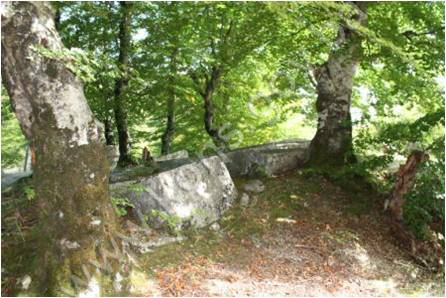
There are six sites of necropolises with stećak tombstones in the village of Čičevo, while 2.5 km to the east of the village, at Ograda or Kula, as it is also known, is another necropolis with 16 stećak tombstones of good workmanship. Two are decorated – a tall gabled tombstone and a tall chest-shaped one – with rope twist, rosette and vine-and-trefoil motifs.
The necropolis is at risk from self-sown vegetation, lichen and moss.
II – PRELIMINARY PROCEDURE
In the procedure preceding the adoption of a final decision to proclaim the property a national monument, the following documentation was inspected:
- Documentation on the location and the current owner and user of the property (copy of cadastral plan and Land Register entry);
- Details of the current condition and use of the property, including a description and photographs, data of war damage, data on restoration or other works on the property, etc.;
- Historical, architectural and other documentary material on the property, as set out in the bibliography forming part of this Decision;
- Copy of cadastral plan, c.p. 155 and 156, c.m. Čičevo, plan no. 4, scale 1:2500, issued on 29 September 2009 by the Department of Geodetics, Proprietary Rights and Cadastral Affairs of Konjic Municipality, Herzegovina-Neretva Canton, Federation of Bosnia and Herzegovina, Bosnia and Herzegovina;
- Copy of Land Register entry for plot nos. 155 and 156, Land Register entry nos. 144 and 97, NAR.and RZ no. 4092/09, issued on 29 September 2009 by the Konjic Land Registry office, Herzegovina-Neretva Canton, Federation of Bosnia and Herzegovina, Bosnia and Herzegovina;
- Letter ref. 05.1-35.2-5/10-2 of 25 January 2010 in which the Commission to Preserve National Monuments sought the opinion of the owner concerning the designation of the necropolis at Ograda (Vlah) in the village of Kula as a national monument of Bosnia and Herzegovina.
The findings based on the review of the above documentation and the condition of the site are as follows:
1. Details of the property
Location
The necropolis with stećci at Ograda or Vlah, as it is now known, is at an altitude of 644 m, latitude 43°31'35.49"N, longitude 18° 2'28.83"E. The site is about 2.5 km to the east of the village of Čičevo.
The National Monument is located on a site designated as cadastral plot no. 155, Land Register entry no. 144, c.p. 156, Land Register entry no. 96, cadastral municipality Čičevo, Municipality Konjic, Federation of Bosnia and Herzegovina, Bosnia and Herzegovina.
Historical information
Since prehistoric times, the roads linking central Bosnia with the Adriatic coast ran along the Neretva valley and its outer margins. With some alterations and adaptations to the route, major roads ran here in antiquity, mediaeval times and the Ottoman period, until the road was laid through the Neretva gorge from Jablanica to the south in the 1880s. The central Bosnian ore-rich mining area, the fertile soils of the Neretva valley, and the rich mountain pastures, all led to the formation of many settlements throughout history, in line with the conditions and demands of their respective times, on the great bend in the Neretva between the mountain massifs of Bitovnja, Bjelašnica and Visočica to the north, and Prenj and Čvrsnica to the south.
In the early mediaeval period, the wider Konjic region consisted of the Neretva župa (county), part of the Zagorja župa (the area around Bjelimići) and part of the Kom župa (the area around Glavatičevo). The earliest reference to the Neretva župa is in the Chronicles of the Doclean priest, written in the mid 12th century. It lay between the župas of Rama and Kom. According to the Chronicles, the Podgorje district also belonged to it. By the mid 11th century the župa had presumably been incorporated into the Bosnian state. From then on until ban (governor) Tvrtko came to power in 1353, it enjoyed special status within the Bosnian state.(1)
2. Description of the property(2)
Description of the stećci
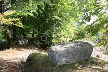
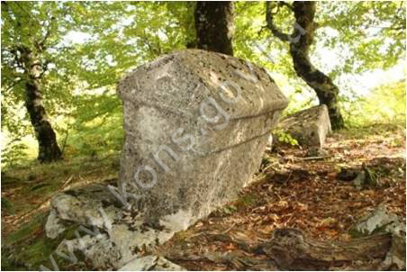
Sixteen graves with stećci have been recorded in the necropolis: 15 chest-shaped and one tall gabled tombstone, of which tombstones no. 16 and 7 are decorated with rope twist, rosette and vine-and-trefoil motifs. They lie east-west, with the exception of nos. 1 and 16.
Stećak no. 1, tall chest, measuring 162 x 77 x 61 cm, lying north-south;
Stećak no. 2, tall chest, measuring 161 x 61 x 82 cm, overturned;
Stećak no. 3, chest, measuring 170 x 63 x 30 cm, partly covered with moss;
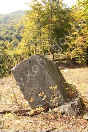
Stećak no. 4, chest, measuring 164 x 67 x 40 cm, partly covered with moss, leaning off true;
Stećak no. 5, measuring 107 x 48 x 10 cm damaged, of indeterminate shape;
Stećak no. 6, measuring 137 x 69 x 27 cm, covered with moss;
Stećak no. 7, gabled with plinth, plinth measuring 174 x 82 x 27, gabled part measuring 160 x 60 x 87 cm, aslant, damaged plinth, partly covered with moss, decorated with rope twist and a rosette;
Stećak no. 8, measuring 157 x 70 x 34 cm, top cracked, partly covered with moss and lichen;
Stećak no. 9, measuring 154 x 73x 39 cm, leaning off true, sinking, partly covered with moss;
Stećak no. 10, measuring 175 x 72 x 56 cm, partly covered with moss;
Stećak no. 11, measuring 175 x 70 x 55 cm, partly covered with moss;
Stećak no. 12, measuring 210 x 125 x 58 cm, split in two places;
Stećak no. 13, measuring 130 x 57 x 23 cm, top cracked, partly covered with moss and lichen;
Stećak no. 14, measuring 149 x 70 x 42 cm, top cracked, partly covered with moss and lichen;
Stećak no. 15, measuring 164 x 90 x 6 cm, almost completely covered with moss;
Stećak no. 16, tall chest with plinth, plinth measuring 250 x 120 x 20, chest measuring 196 x 78 x 116 cm, aslant, sinking, with the plinth completely buried on one side, decorated with a trefoil vine, lying north-south.
3. Legal status to date
The Regional Plan for BiH to 2000 lists 69 sites of necropolises with stećci (3,018 tombstones) as Category III monuments in Konjic Municipality, without precise identification.
4. Research and conservation-restoration works
The National Museum in Sarajevo began a systematic study of the necropolises with stećci in Bosnia and Herzegovina in the 1950s.
Pavao Anđelić records a burial ground with 15 stećci (15 chest-shaped and one gabled) at Ograda, about 2.5 km east of the village of Čičevo. The only decorated tombstone is the gabled one, with a spiral and simple band.(3)
5. Current condition of the property
The findings of an on site visit conducted on 6 October 2009 are as follows:
- 16 stećci were recorded, most of them in a hornbeam wood;
- the stećci are in poor condition, largely covered with plant organisms (moss and lichen) which are breaking up the structure of the stone;
- some of the stećci are leaning off true;
- some of the stećci are sinking into the ground;
- a few of the stećci have been so badly corroded by plant organisms as to be almost amorphous;
- some of the stećci are visibly damaged (split, more or less deeply cracked, or with the top surface damaged).
III – CONCLUSION
Applying the Criteria for the adoption of a decision on proclaiming an item of property a national monument (Official Gazette of BiH nos. 33/02 and 15/03), the Commission has enacted the Decision cited above.
The Decision was based on the following criteria:
A. Time frame
C. Artistic and aesthetic value
C.i. quality of workmanship
C.iii. proportions
C.v. value of details
D. Clarity
D.ii. evidence of historical change
D.iv. evidence of a particular type, style or regional manner
E. Symbolic value
E.i. ontological value
E.ii. religious value
E.v. significance for the identity of a group of people
The following documents form an integral part of this Decision:
- Ownership documentation:
- Copy of cadastral plan, c.p. 155, 156, c.m. Čičevo, plan no. 4, scale 1:2500, issued on 29.9.2009 by the Department of Geodetic, Proprietary Rights and Cadastral Affairs of Konjic Municipality, Herzegovina-Neretva Canton, Federation of Bosnia and Herzegovina, Bosnia and Herzegovina;
- Land Register entries for c.p. 155, Land Register entry no. 144, c.p. 156, Land Register entry no. 96, order no. 4092/09, issued on 29.9.2009 by the Land Registry office, Konjic, Herzegovina-Neretva Canton, Federation of Bosnia and Herzegovina, Bosnia and Herzegovina;
- Photodocumentation:
- Photographs taken on 6.10.2009 by historian Zijad Halilović using Canon 1000D digital camera;
- Technical documentation:
- Technical drawings of the property (drawings of the necropolis and survey of the stećak tombstones), measured and surveyed on 06. 26. 10. 2009 by historian Zijad Halilović and architect Arijana Pašić.
Bibliography
During the procedure to designate the property as a national monument of Bosnia and Herzegovina the following works were consulted:
1975. Anđelić, Pavao. Historijski spomenici Konjica i okoline (Historic Monuments of Konjic and its Environs), I. Konjic, 1975
1980. Redžić, Husref (ed.). Regional Plan for Bosnia and Herzegovina; Stage B - valorization of natural, cultural and historical monuments. Sarajevo: Institute for architecture, town planning and regional planning of the Faculty of Architecture in Sarajevo, 1980
(1) For further historical details, see the Decision by the Commission designating the historic site of the necropolis with stećak tombstones of Česmina glava in Odžaci, Konjic Municipality, as a national monument of BiH, posted on the Commission’s web site: www.kons.gov.ba
(2) For more on a general description of necropolises with stećak tombstones in Konjic Municipality, see the Decision by the Commission designating the historic site of the Ćesmina glava necropolis with stećak tombstones in Odžaci, Municipality Konjic, as a national monument of BiH, on the Commission's web site, www.kons.gov.ba.
(3) Pavao Anđelić, Historijski spomenici Konjica i okoline, I, Konjic:1975, 201
|