Status of monument -> National monument
Published
in the “Official Gazette of BiH”, no. 38/10.
Pursuant
to Article V para. 4 Annex 8 of the General Framework Agreement for Peace in Bosnia and Herzegovina
and Article 39 para. 1 of the Rules of Procedure of the Commission to Preserve
National Monuments, at a session held from 1 to 7 December 2009 the Commission
adopted a
D E C I S
I O N
I
The
sepulchral ensemble of prehistoric tumuli and a necropolis with stećak and
nišan tombstones in the village of Sovići, Municipality Jablanica, is
hereby designated as a National
Monument of Bosnia and Herzegovina
(hereinafter: the National Monument).
The
National Monument consists of the monuments at the following locations in three
mahalas of the village
of Sovići:
1. Gornja
mahala,
-
at Stublenica, a mediaeval
monument – one grave with a stećak,
-
at Zec, a mediaeval
necropolis, five surviving graves with stećak tombstones,
-
at Batuša, a prehistoric
tumulus and an isolated stećak,
2. Srednja
mahala,
-
Srednja mahala 1, at
Hrbine, a prehistoric tumulus and mediaeval graves with two stećak tombstones,
-
Srednja mahala 2, two
surviving graves with stećak tombstones in a Catholic cemetery),
-
Svatovsko groblje
(Ranica), mediaeval necropolis, 18 graves with stećak tombstones,
3. Donja
mahala,
-
Donja mahala 1, a
mediaeval necropolis beside a Muslim burial ground, 21 graves with stećak
tombstones and old nišan tombstones in the Muslim burial ground,
-
Donja mahala 2, by the
Mijić house, eight stećak tombstones,
-
at Vrtla, 17 graves with
stećak tombstones, ,
-
at Plavi Greb, six graves
with stećak tombstones
The
National Monument is located on sites designated as cadastral plot no. 349,
title deed no. 130, Land Register entry no. 130, c.p. 466, 469, title deed no.
405, Land Register entry no. 99, c.p. 467, title deed no. 246, Land Register
entry no. 246, c.p. 468, title deed no. 248, Land Register entry no. 248, c.p.
549, title deed no. 200, Land Register entry no. 200, c.p. 564, 565, title deed
no. 153, Land Register entry no. 153, c.p. 573, title deed no. 22, Land
Register entry no. 22, c.p. 648 (part) and 653, title deed no. 386, Land
Register entry no. 386, c.p. 830, title deed no. 9, Land Register entry no. 9,
c.p. 832, title deed no. 12, Land Register entry no. 12, c.p. 844, title deed
no. 19, Land Register entry no. 19, c.p. 916, 1152, title deed no. 316, Land
Register entry no. 316, c.p. 1158, title deed no. 157, Land Register entry no.
157, c.p. 1509, title deed no. 197, Land Register entry no. 197, c.p. 1619,
title deed no. 60, Land Register entry no. 60, cadastral municipality Sovići,
Municipality Jablanica, Federation of Bosnia and Herzegovina, Bosnia and
Herzegovina.
The
provisions relating to protection measures set forth by the Law on the
Implementation of the Decisions of the Commission to Preserve National
Monuments, established pursuant to Annex 8 of the General Framework Agreement
for Peace in Bosnia and Herzegovina (Official Gazette of the Federation of BiH
nos. 2/02, 27/02, 6/04 and 51/07) shall apply to the National Monument.
II
The
Government of the Federation of Bosnia and Herzegovina (hereinafter: the
Government of the Federation) shall be responsible for providing the legal,
scientific, technical, administrative and financial measures necessary for the
protection, conservation and presentation of the National Monument.
The
Commission to Preserve National Monuments (hereinafter: the Commission) shall
determine the technical requirements and secure the funds for preparing and
erecting signboards with basic details of the monument and the Decision to
proclaim the property a National Monument.
III
To ensure
the on-going protection of the National Monument on the site defined in Clause
1 para. 3 of this Decision, the following protection measures are hereby
stipulated:
-
a regulatory plan and management
plan shall be drawn up to ensure that the integrity and clarity of the National
Monument are preserved, to identify the potential for the modern development of
the village in a manner that will not be detrimental to the National Monument,
and to identify opportunities for linking the sites for the purpose of
presentation of the National Monument;
-
works on the
infrastructure are prohibited except with the approval of the Federal Ministry
responsible for regional planning (hereinafter: the relevant ministry) and
under the expert supervision of the heritage protection authority of the
Federation of Bosnia and
Herzegovina (hereinafter: the heritage
protection authority);
-
all works that could have
the effect of endangering the National Monument are prohibited, as is the
erection of temporary facilities or permanent structures not intended solely
for the protection and presentation of the National Monument;
-
the construction of
buildings the appearance or use of which could be detrimental to the National
Monument is prohibited within a radius of 50 m from the boundaries of the
protected site;
-
the dumping of waste is
prohibited.
Gornja mahala
-
all works are prohibited
other than research and conservation and restoration works, including those
designed to display the monument in situ, with the approval of the
relevant ministry and under the expert supervision of the heritage protection
authority;
-
the site of the monument
shall be open and accessible to the public, and may be used for educational and
cultural purposes;
-
the use of modern
technical solutions is permitted in order to identify the positions of the
stećak tombstones;
-
the relocation or removal
of the stećak tombstones from the graves is prohibited;
-
during restoration,
conservation and routine maintenance of the monument, its original appearance
shall be maintained, and original materials and techniques shall be used;
Srednja mahala
-
all works are prohibited
other than research and conservation and restoration works, including those
designed to display the monument in situ, with the approval of the
relevant ministry and under the expert supervision of the heritage protection
authority;
-
the site of the monument
shall be open and accessible to the public, and may be used for educational and
cultural purposes;
-
the relocation or removal
of the stećak tombstones from the graves is prohibited;
-
during restoration,
conservation and routine maintenance of the monument, its original appearance
shall be maintained, and original materials and techniques shall be used;
-
the course of the River
Doljanka shall be made good.
Donja mahala
-
all works are prohibited
other than research and conservation and restoration works, including those
designed to display the monument in situ, with the approval of the
relevant ministry and under the expert supervision of the heritage protection
authority;
-
the site of the monument
shall be open and accessible to the public, and may be used for educational and
cultural purposes;
-
the relocation or removal
of the stećak tombstones from the graves is prohibited;
-
during restoration,
conservation and routine maintenance of the monument, its original appearance
shall be maintained, and original materials and techniques shall be used;
-
the course of the River
Doljanka shall be made good.
Conservation-restoration
projects should cover:
-
repairing damage to the
stećak and nišan tombstones;
-
conservation-restoration
works based on original documentation and preliminary investigative works;
-
the reconstruction of the
necropolis and its restoration to its orginal condition.
The
following urgent protection measures are hereby prescribed with a view
to protecting the National Monument:
-
conducting a preliminary
survey of its condition to identify the nature and extent of damage;
-
archaeological
investigations, after first drawing up a programme;
-
making good damage to the
most endangered sites;
-
relocating the newly-built
road and restoring the National Monument to its original condition;
-
clearing the National
Monument of litter and waste and tidying the necropolis;
-
clearing lichen and moss
from the stećak and nišan tombstones and making good any damage.
The area
is an archaeological site, and all investigative works must therefore be
carried out in the presence of an archaeologist.
IV
All
movable artefacts found during archaeological investigations shall be housed in
the nearest museum or in the National Museum of Bosnia and Herzegovina in Sarajevo, processed and
suitably presented.
The
removal of the movable artefacts referred to in the previous paragraph (from Bosnia and Herzegovina
is prohibited.
By way of
exception to the provisions of paragraph 2 of this Clause, if the leader of the
investigations determines that a given artefact must be processed abroad, and
provides evidence to that effect to the Commission, the Commission may permit
the temporary removal of the artefact from the country subject to detailed
conditions.
Upon
receipt of a report on the investigations conducted, the Commission shall
identify which movable artefacts shall be subject to protection measures to be
determined by the Commission.
V
All
executive and area development planning acts are hereby revoked to the extent
that they are not in accordance with the provisions of this Decision.
VI
Everyone,
and in particular the competent authorities of the Federation of Bosnia and
Herzegovina, the Canton, and urban and municipal authorities, shall refrain
from any action that might damage the National Monument or jeopardize the
preservation thereof.
VII
The Government
of the Federation, the Federal Ministry responsible for regional planning, the
Federation heritage protection authority, and the Municipal Authorities in
charge of urban planning and land registry affairs, shall be notified of this
Decision in order to carry out the measures stipulated in Articles II to VI of
this Decision, and the Authorized Municipal Court shall be notified for the
purposes of registration in the Land Register.
VIII
The
elucidation and accompanying documentation form an integral part of this
Decision, which may be viewed by interested parties on the premises or by
accessing the website of the Commission (http://www.aneks8komisija.com.ba)
IX
Pursuant
to Art. V para 4 Annex 8 of the General Framework Agreement for Peace in Bosnia and Herzegovina,
decisions of the Commission are final.
X
This
Decision shall enter into force on the day following its publication in the
Official Gazette of BiH.
This
Decision has been adopted by the following members of the Commission: Zeynep Ahunbay,
Martin Cherry, Amra Hadžimuhamedović, Dubravko Lovrenović, and Ljiljana Ševo.
No: 05.2-2.2-40/2009/65
2 December 2009
Sarajevo
Chair of
the Commission
Ljiljana
Ševo
E l u c i
d a t i o n
I – INTRODUCTION
Pursuant
to Article 2, paragraph 1 of the Law on the Implementation of the Decisions of
the Commission to Preserve National Monuments, established pursuant to Annex 8
of the General Framework Agreement for Peace in Bosnia and Herzegovina, a
“National Monument” is an item of public property proclaimed by the Commission
to Preserve National Monuments to be a National Monument pursuant to Articles V
and VI of Annex 8 of the General Framework Agreement for Peace in Bosnia and
Herzegovina and property entered on the Provisional List of National Monuments
of Bosnia and Herzegovina (Official Gazette of BiH no. 33/02) until the
Commission reaches a final decision on its status, as to which there is no time
limit and regardless of whether a petition for the property in question has
been submitted or not.
On 5
August 2009 Jablanica Municipality submitted to the Commission a proposal /petition
to designate the mediaeval necropolises with stećak tombstones at Sovići as a national monument of Bosnia and Herzegovina.
Pursuant
to the provisions of the law, the Commission proceeded to carry out the
procedure for reaching a final decision to designate the Property as a National
Monument, pursuant to Article V para. 4 of Annex 8 and Article 35 of the Rules
of Procedure of the Commission to Preserve National Monuments.
Statement of Significance
The
national monument consists of two prehistoric grave mounds (tumuli), 78 graves
with stećci (pl. of stećak), 27 nišan tombstones and eight stećci no longer in
situ, at a total of nine sites in the village
of Sovići, Jablanica Municipality.
This historic site is of particular significance on account of its mixture, and
in places merger, of burial grounds from different periods: mediaeval graves
with stećci located on prehistoric tumuli, 16th-19th century Muslim burial
grounds mingled with stećci, Catholic graves of recent date in mediaeval burial
grounds with stećci, and so on. The concentration of graves ranging in date
from prehistory to the 19th century reflects the unbroken density of habitation
in the village of
Sovići.
The
stećci at these sites in Sovići are slab-shaped, chest-shaped or gabled
(sarcophagus-like). Five of the 85 stećci are decorated with realistic and
symbolic designs (a scene of a combat between a cavalryman and an infantryman,
figures in a round dance holding birds, a rosette, the figure of a warrior
holding a lance and a sword and with his body stabbed by a sword, a cross, a
female round dance. stars, a crescent moon and a sword).
II – PRELIMINARY PROCEDURE
In the
procedure preceding the adoption of a final decision to proclaim the property a
national monument, the following documentation was inspected:
-
Documentation on the
location and the current owner and user of the property (copy of cadastral plan
and Land Register entry).
-
Details of the current
condition and use of the property, including a description and photographs,
data of war damage, data on restoration or other works on the property, etc.
-
Historical, architectural
and other documentary material on the property, as set out in the bibliography
forming part of this Decision.
-
Pursuant to Article 12 of
the Law on the Implementation of Decisions of the Commission to Preserve
National Monuments Established Pursuant to Annex 8 of the General Framework
Agreement for Peace in Bosnia and Herzegovina,
the following procedures were carried out for the purpose of designating the
property as a national monument
of Bosnia and Herzegovina:
-
A letter ref.
02-02-1133-10/09-VIII of 30 June 2009 supplied the resolution of Jablanica
County Council prohibiting the relocation of stećci beyond the boundaries of
Jablanica Municipality and an article in Dnevni avaz daily newspaper of 13 July
2007 in which local residents both Muslim and Catholic expressed their dismay
at the removal of stećci from the village of Sovići
-
A letter ref.
02-36-9/09-101 of 10 August 2009 to Jablanica
Municipality, notifying
it that members of staff from the Commission would conduct a technical and
photographic survey of the monuments at the various sites in Sovići and
requesting the Municipality to provide experts (surveyors) to assist in
identifying the plots
-
A letter ref.
05.2-26.1-9/09-225 of 17 November 2009 requesting the Land Registry office of
the Municipal Court in Konjic to provide a copy of the Land Register entries
for the identified plots at the sites in the village of Sovići, Jablanica
Municipality
-
A letter ref.
07-40-4-3198-1/09 of 25 August 2009 was received from the Institute for the
Protection of Monuments of the Federal Ministry of Culture and Sport.
The
findings based on the review of the above documentation and the condition of
the site are as follows:
1. Details of the property
Location
The village of Sovići
is in the western part of Jablanica
Municipality on the
Jablanica–Doljani–Blidinje–Duvno road, about 12 km from Duvno as the crow
flies. The village consists of three mahalas: Upper, Middle and Lower.
The
National Monument is located on sites designated as cadastral plot no. 349,
title deed no. 130, Land Register entry no. 130, c.p. 466, 469, title deed no.
405, Land Register entry no. 99, c.p. 467, title deed no. 246, Land Register
entry no. 246, c.p. 468, title deed no. 248, Land Register entry no. 248, c.p.
549, title deed no. 200, Land Register entry no. 200, c.p. 564, 565, title deed
no. 153, Land Register entry no. 153, c.p. 573, title deed no. 22, Land
Register entry no. 22, c.p. 648 (part) and 653, title deed no. 386, Land Register
entry no. 386, c.p. 830, title deed no. 9, Land Register entry no. 9, c.p. 832,
title deed no. 12, Land Register entry no. 12, c.p. 844, title deed no. 19,
Land Register entry no. 19, c.p. 916, 1152, title deed no. 316, Land Register
entry no. 316, c.p. 1158, title deed no. 157, Land Register entry no. 157, c.p.
1509, title deed no. 197, Land Register entry no. 197, c.p. 1619, title deed
no. 60, Land Register entry no. 60, cadastral municipality Sovići, Municipality
Jablanica, Federation of Bosnia and Herzegovina, Bosnia and Herzegovina.
Historical information
There
were already human communities in what is now Jablanica in the 3rd and 2nd
millennia, as evidenced by the remains of hill forts and tumuli discovered in
Djevoro, Glogošnica, Križ hill above the village of Mrakovo, the hill above the
village of Dobrigošće, Gradište near Ostrošac, Orlovac on Slatina, Ružno hill
in Čehari, and above Palića mahala in Baćina. The remains of tumuli have also
been found in the hamlet of Batuša in Gornja (upper) mahala and in Hrbine in
Srednja (middle) mahala in the village of Sovići, and in the Marića burial
ground of Lokve on Risovac(1).
Prehistoric
grave mounds or tumuli are known by a variety of terms, including barrow,
mound, burial mound, tumulus and hill (the terms used in the local language in Bosnia and Herzegovina
are gomila, gromila, kamena gomila, grobna gomila, tumulus, unka, humka,
unjka and zaspa). They are the most numerous prehistoric structures,
mainly concentrated in southern Bosnia,
the Drina valley and Herzegovina,
with scattered instances in central and northern Bosnia. Tumuli are earth mounds,
usually circular in plan, though sometimes elliptical, originally probably
conical in shape, but now mainly reduced to a dome shape, some quite high,
others lower. They consist of a mixture of earth and stone, except in typically
karst areas, where they are of stone alone (except those in the poljes).
With the exception of tumuli serving as fortifications (liminal tumuli as part
of a hill fort system) and those used for cult purposes, known locally as zaspa(2), most tumuli are sepulchral
structures with one or more burials, which may be connected (burials from the
same chronological stage in family or clan tumuli) or even from different
stages of the same period. It is not uncommon to find burials from entirely
different periods (for instance, later burials dating from Roman times, or even
entire mediaeval necropolises on prehistoric tumuli)(3).
Most of
the hill forts in the Jablanica area date from the late Bronze Age (late 2nd
and early 1st century BCE), with a few of later, Iron Age date. Soil erosion
and plant growth have combined to obliterate most of them almost entirely. There
are very few vestiges of the culture of Antiquity (1st to 4th century CE) in
the Jablanica area. Thus far, Roman sites have been discovered in Donji
Paprasak and near Žuglići, and Roman monuments have been found on Falanovo
hill, Hudutski and Ankula in Grac.
Of
particular note from late Antiquity (late 3rd to early 6th century CE) is the
fort known as Grad on a hill between Ostošac and Ribići.
In
mediaeval times much of the area of present-day Jablanica Municipality
consisted of the mediaeval župa (county) of Neretva, the county town of
which was Konjic, with part of the counties of Rama and Planina (the Risovac,
Tovarnica and Čvrsnica area).
The
earliest reference to the Neretva župa is in the Chronicles of the Doclean
priest, written in the mid 12th century. It lay between the župas of Rama
and Kom. According to the Chronicles, the Podgorje district also belonged to
it. By the mid 11th century the župa had presumably been incorporated into the
Bosnian state. From then on until ban (governor) Tvrtko came to power in
1353, it enjoyed special status within the Bosnian state(4). The economic and political
activities of the Bosnian rulers in Neretva county can be traced from the mid
14th century. In the early 15th century the boundaries were drawn between the
later Crown lands and the feudal holdings of the Kosača family. Between 1404
and 1463, the Bosnian part of Neretva county belongs to the Crown lands, while
the Hum part of the Neretva and Kom belonged to the Kosača feudal lands, later
known as Herzegovina.
The River Neretva formed the boundary between these two districts, from the
boundaries of Kom county to those of Rama county. The area on the left bank of
the Neretva belonged to the Kosačas and that on the right bank to the Crown
lands. In the summer of 1463, an auxiliary Ottoman army led by Mahmut pasha
Anđelović conquered both Neretva and Kom. Hum Neretva, the fort of Borovac and
the western part of Bosnian Neretva were liberated in a counter-action by
herceg Stjepan between July and September that year, but the region was finally
conquered in mid 1465 during a campaign by Isa-bey Ishaković, sanjak-bey of
Bosnia, into the herceg’s lands(5).
The
earliest official record of the name and toponym Jablanica in Ottoman sources
is in the summary defter or tax census of the Bosnian sanjak for 1458, which
lists Jablanica as belonging to the Neretva nahija [minor administrative
entity] and as a timar [feudal holding with military obligations] of ćehaja
[deputy] Musa. In 1488/89, Jablanica was registered as a timar of Sinan bey, son
of Islam Kovač.
The village of Sovići
is in the western part of Jablanica
Municipality on the
Jablanica–Doljani–Blidinje–Duvno road. In the mid 19th century it became part
of the Prozor kadiluk [area under the administration of a kadi or
judge]; at that time it was second only to Rumbok as the wealthiest village
with the largest population in the entire kadiluk(6).
2. Description of the property
Jablanica Municipality is
mainly mountainous, but also includes part of the river Neretva valley and its
tributaries and the Jablanica lake. The south-eastern boundary of the
municipality consists of the mountain peaks of Veliki Prenj, Stajski gvod and
Aleksin han in the Neretva valley, from where it rises to the south and west to
Mts Plasa and Čvrsnica and the Blidinje high plateau and on via Mt Vran and
Keđara to Snježnica. The northern boundary consists of the slopes of Baćina and
Oklanica towards Slatina and Bokševica, descending from above Mrakovi down to
the Jablanica lake. The eastern boundary starts at Ribički bridge and rises to
Štrbini, Rečici and Borje as far as Crnoglav on Mt Prenj. Thus far a few
prehistoric grave mounds, a number of Roman sites and the old Roman road from
the Duvno plain via Blidinje to Rama have been identified, along with two
mediaeval forts(7).
Thus far
42 sites in Jablanica have been recorded, with 683 stećci, not one of which,
uniquely, bears an epitaph. The necropolises at Dugo polje and Risovac have the
most stećci and are richest in decoration. Stećci have also been recorded in
Sovići, Doljani, Žuglići, Šabančići, Mrakovo, Rodići, Donja Slatina,
Dobrigošće, Krstac, Čehari, Donja Jablanica, Djevoro, Glogošnica and Ravna. When
considered in the light of living conditions and climate, the number and
diversity of these monuments provide clear evidence of the area’s population
density(8). The
stećci in this area date from the 14th to the 16th century(9).
Ten sites
have been identified in the village
of Sovići with two
prehistoric grave mounds and a total of 85 stećci, in the Upper, Middle and
Lower mahalas.
Gornja mahala
Three
sites in Upper mahala have been recorded, with one prehistoric tumulus and
seven stećci.
Stublenica
158 x 70
cm, h = 110 cm, gabled with plinth, damaged, undecorated, lying west – east,
located on a plot designated as c.p. no.844.
Zec
Five
graves with stećci have been recorded here, partly buried, covered with lichen
and overgrown with grass, undecorated. They are located on a plot designated as
c.p. no. 830.
1. 165 x
110 cm, h = 54 cm, chest,
2. 174 x
120 cm, h = 37 cm, slab,
3. 164 x
110 cm, h = 45 cm, slab,
4. 120 x 87
cm, h = 110 cm, gabled,
5. 187 x
117 cm, h = 28 cm, slab.
Batuša
138 x 100
cm, h = 75 cm, isolated chest-shaped stećak, undecorated, on a small
prehistoric tumulus, has been moved from its original position, located on a
plot designated as c.p. no.832.
Srednja mahala
Another
three sites have been recorded in Middle mahala, with one prehistoric tumulus
and 21 stećci.
Hrbine,
also known as Srednja mahala 1
This
site, on part of plot c.p. 349, consists of a prehistoric tumulus on which are
two graves with chest-shaped stećci.
1. 160 x 80
cm, h = 65 cm, chest,
2. 150 x 95
cm, h = 97 cm, chest.
Srednja
mahala 2
Two
graves with stećci have been recorded in a Catholic cemetery still in active
use on plot c.p. 916. These could not be examined since they are completely
buried.
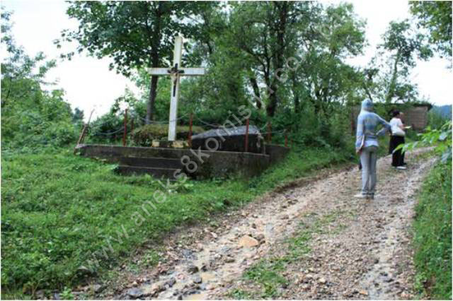
Ranica
necropolis – Svatovsko groblje
The
necropolis is on the right bank of the river Doljanka, and is one of the most
endangered necropolises in Jablanica
Municipality. It is
located on a small elevation above the river, into which about half of the
stećci have already fallen. At the entrance to the necropolis there are now two
stećci set in concrete and a large cross where the local Catholics perform
religious worship. A striking feature of this necropolis is stećak no. 12, with
a scene of a women’s round dance, a star, a crescent moon and a sword. Almost
all the stećci are covered with moss and lichens. In the 1970s there were 35
stećci in this necropolis, only 18 of which can now be identified, and not all
of these could be examined since they are completely buried, with only their
outlines visible. They are on plots designated as c.p. nos. 466, 467, 468, 469.
1. 145 x 72
cm, h = 38 cm, slab,
2. 15 x 15 cm,
h = 38 cm, slab,
3. 137 x 60
cm, h = 35 cm, slab,
12. 180 x 93
cm, h = 100 cm, tall decorated chest,
13. 155 x 58
cm, h = 66 cm, gabled,
14. 168 x 73
cm, h = 65, chest,
15. 230 x
130 cm, h = 60 cm, broken into two pieces,
16. 176 x
148 cm, h = 44 cm, chest,
17. 160 x 73
cm, h = 66 cm, chest,
18. 230 x
148 cm, h = 64 cm, chest.
Donja mahala
Four
sites have been recorded in Lower mahala, with 57 stećci.
Donja
mahala 1
This site
contains 21 graves with stećci (20 chest-shaped and one gabled), and graves
with old nišan tombstones. The stećci are on plot c.p. 1158, with the exception
of stećak no. 21, which is on plot 1152, where the old nišan tombstones are
also located. The stećci are partly or wholly buried, and covered with lichens,
moss and vegetation. There is also a field latrine in the necropolis, and the
concrete foundations of a small building.
The
measurements of the stećci are:
1. 155 x 113
cm, h = 71 cm chest,
2. 190 x
105 cm, h = 30 cm chest,
3. 150 x 95
cm, h = 50 cm chest,
4. 154 x
100 cm, h = 40 cm chest
5. 195 x
100 cm, h = 40 cm chest,
6. 120 x 70
cm, h = 65 cm chest,
7. 175 x
114 cm, h = 50 cm chest,
8. 198 x 70
cm, h = 65 cm chest,
9. 185 x 90
cm, h = 57 cm gabled,
10. 200 x 92
cm, h = 30 cm chest,
11. 140 x 62
cm, h = 36 cm chest,
12. 160 cm
buried h = 52 cm chest,
13. 66 cm
buried h = 52 cm broken chest,
14. 130 x 80
cm, h = 46 cm indeterminate shape,
15. 137 x 66
cm, h = 70 cm chest,
16. 160 x 76
cm, h = 40 cm chest,
17. 113 x 75
cm, h = 82 cm chest,
18. 160 x
100 cm, h = 40 cm chest,
19. 158 x 86
cm, h = 47 cm chest,
20. 170 x 66
cm, h = 82 cm chest,
21. 168 x 80
cm, h = 45cm, chest.
Necropolis
with nišan tombstones
The
burial ground in the village of Sovići, which is still in active use, contains
not only tombstones of recent date but also about thirty old nišan tombstones,
all visibly damaged by exposure to the elements and as a result of the type of
stone used. They have no epitaphs, but judging from their appearance and the
extent of damage they date from the 18th or 19th century.
Description
of the nišan tombstones:
1. Woman’s
nišan, covered in moss, rectangular in section 22 x 10 cm with a height of 55
cm.
2. Man’s
nišan with pleated turban, partly buried, octagonal in section with sides of 14
and 8 cm. The height of the nišan visible above ground is 53 cm.
3. Nišan
with woman’s cap, octagonal in section with sides of 10 and 12 cm and a height
of 52 cm.
4. Man’s
nišan with aga’s turban, square in section 17 x 17 cm with a height of 45 cm.
5. Man’s
nišan with pleated turban, octagonal in section with sides of 7 and 13 cm and a
height of 40 cm.
6. Man’s
nišan with pleated turban, measuring 17 x 14 x 45 cm, partly buried, without
epitaph.
7. Man’s
nišan with aga’s turban, octagonal in section, circumference 80 cm with a
height of 60 cm.
8. Man’s
nišan with turban, rectangular in section 20 x 17 cm with a height of 74 cm. A
four-fingered hand is carved on the nišan, extending down from the top, a motif
found on stećci and seen here on a nišan for the first time.
9. Nišan in
the form of a stele measuring 27 x 16 x 60 cm, without epitaph.
10. Nišan
with pleated turban rectangular in section 35 x 29 cm with a height of 102 cm.
11. Man’s
nišan with pleated turban, covered in moss, octagonal in section with sides of
23 and 10 cm and a height of 70 cm.
12.
Small-sized man’s nišan with turban, buried with only the top of the turban
visible above ground.
13. Woman’s
nišan on its side, rectangular in section 17 x 9 cm with a height of 48 cm.
14. Man’s
nišan on its side, with turban, square in section 12 x 12 cm with a height of
65 cm.
15. Man’s
nišan with pleated turban, octagonal in section, circumference 70 cm with a
height of 45 cm,
16. Man’s
nišan with aga’s turban, measuring 20 x 20 x 53 cm.
17. Man’s
nišan, fallen, with čatal (bifurcate) turban measuring 10.5 x 10.5 x 70 cm.
18. Man’s
nišan with pleated turban rectangular in section 16 x 14 cm with a height of 33
cm.
19. Nišan on
its side, with turban, octagonal in section with sides of 14 and 12 cm and a
height of 80 cm.
20. Nišan
with pleated turban measuring 12 x 7 x 52 cm.
21. Man’s
nišan, damaged, with pleated turban, octagonal in section with sides of 13 and
10 cm and a height of 53 cm.
22. Man’s
nišan with pleated turban circular in section, diameter 83 cm with a height of
60 cm.
23. Woman’s
nišan rectangular in section 33 x 13 cm with a height of 58 cm.
24. Woman’s
nišan rectangular in section 28 x 15 cm with a height of 48 cm.
25. Woman’s
nišan rectangular in section 29 x 16 cm with a height of 64 cm.
26. Woman’s
nišan rectangular in section 23 x 13 cm with a height of 42 cm.
27. Woman’s
nišan rectangular in section 26 x 14 cm with a height of 48 cm.
Donja
mahala 2 – Mijić house
Two
groups of stećci have been recorded here. One is by the road, where the stećci
were moved about 10 m to the west when the road through the village of Sovići
was laid. Originally they lay west-east.
The
necropolis contains 8 stećci (three tall chests, two chests and three slabs). While
logging the tombstones here, five were found (three chests and two slabs),
along with one cruciform tombstone of more recent date. The stećci are located
on a plot designated as c.p. no. 1509. One stećak is decorated with a large
Greek cross.
1. 110 x
108 cm, h = 30 cm, slab,
2. 178 x
128 cm, h = 77, chest,
3. 162 x 91
cm, h = 98 cm, decorated chest,
4. 180 x
150 cm, h = 30 cm, slab,
5. 153 x 80
cm, h = 58 cm, chest,
6. 97 x 67 cm,
cruciform.
The other
group of stećci is between the houses in the village. They are of indeterminate
shape, and undecorated. Local residents have laid concrete beneath some of the
stećci to prevent the bones from coming away from the graves. The stećci are on
plot c.p. 549.
The
stećci measure:
1. 166 x 65
x 110 cm,
2. 220 x 90
x 64 cm,
3. 115 x 65
x 35 cm,
4. 165 x 92
x 64 cm,
5. 132 x 120
x 68 cm,
6. 110 x 65
cm, stećak completely buried.
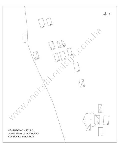
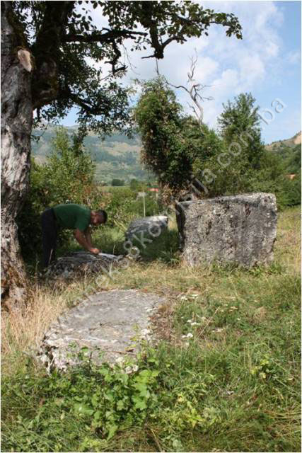
Vrtla
(Gunjača)
Here A.
Zelenika recorded 23 stećci (5 chests, one tall chest and 17 slabs). While
cataloguing here, 17 graves with stećci were identified (6 chests, 5 slabs and
a number that are buried so that their shape could not be determined), lying
west – east. Three (nos. 2, 3 and 4) are decorated. The north side of stećak
no. 2 is decorated with a combat scene between a cavalryman and an infantryman,
and the south side with three figures in a circle holding birds. At the west
end is a crescent moon and a damaged rosette.
Stećak
no. 3 is decorated with the standing figure of a warrior holding a
lance and a sword, his body stabbed by a sword, and with two small crosses
beside him.
Stećak
no. 4 has a relief circle at the west end.
The
stećci are located on a plot designated as c.p. no. 564, 565 and 573. The other
stećci are almost entirely buried, covered with lichen and overgrown with
grass.
1. 176 x 90
cm, h = 26 cm, slab,
2. 178 x
105 cm, h = 78 cm, tall decorated chest,
3. 175 x
102 cm, h = 47 cm, decorated slab,
4. 157 x 76
cm, h = 54 cm, chest,
5. 138 x 86
cm, h = 64 cm, chest,
6. 146 x 86
cm, h = 44 cm, chest,
7. 180 x 90
cm, h = 26 cm, slab,
8. 160 x 76
cm, buried, slab,
9. 170 x 95
cm, h = 30, slab,
10. 165 x 76
cm, buried,
11. 135 cm, completely
buried,
12. 150 x 93
cm, h = 40 cm, chest,
13. Completely
buried,
14. 164 x 84
cm, h = 48, chest,
15. 190 x 64
cm, h = 21 cm, half buried, slab,
16. 150 x 80
cm, buried,
17. 178 x 94
cm, h = 48, half buried.
Plavi
Greb
Six
graves with stećci were recorded on the left bank of the river Doljanka, at
Plavi Greb. The stećci, which are slab shaped and chest shaped, have not
previously been recorded. They are of crude workmanship, damaged and
overturned, and are at risk of falling into the river. They are located on plot
c.p. 1619.
1. 223 x
216 cm, h = 33 cm, slab,
2. 170 x 63
cm, h = 96 cm, chest,
3. 180 x
103 cm, h = 35 cm, slab,
4. 210 x
140 cm, buried slab,
5. 208 x 96
cm, h = 56 cm, chest,
6. 175 x
132 cm, h = 86, chest.
3. Legal status to date
The
Regional Plan for BiH to 2000 lists 13 sites of necropolises with stećci (216
stećci) as category II monuments, without specific identification(10).
A letter
from the Institute for the Protection of Monuments of the Federal Ministry of
Culture and Sport dated 25 August 2008 lists the properties as follows:
1. Upper
mahala, Sovići, Municipality Jablanica,
-
Baruša, prehistoric
tumulus and mediaeval stećak, Bronze or Iron Age and late mediaeval period.
-
Stublenica, mediaeval
monuments – one stećak, late mediaeval period
-
Zec, mediaeval necropolis,
5 surviving stećci, late mediaeval period
2. Middle
mahala, Sovići , Municipality Jablanica
-
Middle mahala 1,
prehistoric tumulus and mediaeval monuments (2 stećci), Bronze or Iron Age and
late mediaeval period
-
Middle mahala 2, mediaeval
monuments (2 surviving stećci in a Catholic cemetery), late mediaeval period,
-
Svatovsko groblje (Ranica),
mediaeval necropolis, 35 surviving stećci, late mediaeval period.
3. Lower
mahala, Sovići, Municipality Jablanica
-
Lower mahala 1, mediaeval
necropolis by Muslim burial ground, 23 surviving stećci, late mediaeval period,
-
Lower mahala 2, mediaeval
necropolis, 8 surviving stećci, late mediaeval period,
-
Vrtla, Sovići – Donja
mahala, mediaeval necropolis, 23 surviving stećci, late mediaeval period.
These
properties were not on the Register of Cultural Monuments of the Socialist
Republic of Bosnia and Herzegovina.
4. Research and
conservation-restoration works
Research
works, consisting of recording and gathering information on the stećci, were
carried out by Anđelko Zelenika and published in 1985 in Hercegovina,
periodical for the cultural and historical heritage, issue IV.
No
conservation or restoration works have been carried out.
5. Current condition of the
property
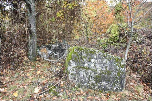
The
findings of on-site inspections conducted on 16 May and 18 August
2008 were as follows:
-
the tombstones are at risk
of rapid deterioration as a result of neglect
-
some of the stećci are
chipped, damaged, overturned, partly or wholly buried, or have fallen into the
river Doljanka
-
the tombstones are covered
to a greater or lesser extent by plant organisms (lichens and moss), which are
breaking down the structure of the stone.
6. Specific risks
-
deterioration of the
necropolis as a result of long-term neglect,
-
adverse weather
conditions,
-
self-sown vegetation,
-
displacement of the stećci
from the graves by natural slippage or by building and infrastructure works,
-
removal of the stećci from
the graves without investigative works and documentation
III – CONCLUSION
Applying
the Criteria for the adoption of a decision on proclaiming an item of property
a national monument (Official Gazette of BiH nos. 33/02 and 15/03), the
Commission has enacted the Decision cited above.
The
Decision was based on the following criteria:
A. Time frame
B. Historical value
C. Artistic and aesthetic value
C.i. quality of workmanship
C.iii. proportions
C.v. value of details
D. Clarity
D.i. material evidence of a lesser known
historical era
E. Symbolic value
E.ii. religious value
E.v. significance for the identity of a group of
people
G. Authenticity
G.i. form and design
G.ii. material and content
G.iii. use and function
The
following documents form an integral part of this Decision:
-
Ownership documentation
-
Copy of cadastral plans
for c.p. 466 and 469, title deed no. 405, c.p. 467, title deed no. 246, c.p.
468, title deed no. 248, c.m. Sovići, Municipality Jablanica (letter from
Jablanica Municipality: petition submitted on 5 August 2009),
-
Copy of cadastral plans
for c.p. 349, title deed no. 130, c.p. 549, title deed no. 200, c.p. 564, 565,
title deed no. 153, c.p. 573, title deed no. 22, title deed no. 12, c.p. 844,
title deed no. 19, c.p. 916, 1152, title deed no. 316, c.p. 1158, title deed
no. 157, c.p. 1509, title deed no. 197, c.p. 1619, title deed no. 60, c.m.
Sovići, Municipality Jablanica (obtained in person on 18 August 2009 from
Jablanica Municipality),
-
Letter from the Municipal
Court in Konjic, Land Registry office, NAR and RZ ref. 4921/09 of 18 November
2009 enclosing Land Register entries no. 9, 12, 19, 22, 60, 99, 130, 153, 157,
197, 200, 246, 248, 316, 386, c.m. Sovići, Municipality Jablanica.
-
Documentation on previous
protection of the property
-
Letter from Jablanica Municipality: petition submitted on 5
August 2009, enclosing Programme for the protection and survey of stećci in the
Jablanica area, drawn up by the Regional Institute for the Protection of
Cultural Monuments and nature, Mostar, 1984,
-
Letter from the Institute
for the Protection of Monuments of the Federal Ministry of Culture and Sport
ref. 07-40-4-3198-1/09 of 25 August 2009.
-
Photodocumentation
-
Photographs of the
property taken on 16 May and 18 August 2009 by historian Zijad Halilović using
Canon EOS 450D digital camera.
-
Technical documentation
-
Technical drawings of the
property (plan of the necropolis, drawings of the stećak and nišan tombstones),
measured and surveyed on 16 May and 18 August 2009 by historian Zijad
Halilović, architect and trainee Arijana Pašić, and calligrapher Hazim
Numanagić (freelance associate).
Bibliography
During
the procedure to designate the property as a national monument of Bosnia
and Herzegovina the following works were
consulted:
1980. Various authors. Regional Plan for Bosnia and Herzegovina; Stage B –
valorization of natural, cultural and historical monuments. Sarajevo: Institute for architecture, urbanism and spatial
planning of the Faculty of Architecture in Sarajevo
and Sarajevo Planning Institute for Bosnia and Herzegovina, 1980, 52.
1982. Anđelić, Pavao. “Teritorijalnopolitička organizacija
srednjovjekovne župe Neretve i njezino mjesto u širim političkom okvirima”
(Territorial political organization of the mediaeval Neretva county and its
place in the wider political context) in Studije o teritorijalnopolitičkoj
organizaciji srednjovjekovne Bosne (Studies on the territorial political
organization of mediaeval Bosnia).
Sarajevo: 1982,
108-110.
1985. Zelenika, Anđelko. “Stećci jablaničkog područja” (Stećci of the
Jablanica Region), Hercegovina IV, 1985, 51-71.
1988. Arheološki leksikon Bosne i Hercegovine (Archaeological
Lexicon of BiH), Vol. I. Sarajevo: 1988, 190.
2003. Karić, Omer. “Jablanica kroz stoljeća,” in Jablanica 100
godina školstva (1903-2003) (Jablanica through the centuries: 100 years of
education in Jablanica [1903-2003]). Jablanica: 2003, 13-36.
(1) Omer Karić,
“Jablanica kroz stoljeća” in Jablanica 100 godina školstva (1903-2003),
Jablanica 2003, 14.
(2) Zaspa
is a local term for a particular form of prehistoric tumulus in western Bosnia,
increasingly now being replaced by words such as humka, unjka, crkvina,
glavica etc., but preserving the tradition that they are buried churches.
They are ordinary tumuli covered with earth or a mixture of earth and sand,
sometimes with stone too, and are large in size, even as much as 10 m in height.
They were first recorded by F. Fiala in 1896. The best known are the zaspa in
Benkovac near Bosanska Krupa, Crkvina in Johovica near Bosanski Novi, Glavica
(Hunjka) in Rejzović near Ključ, and Hunka in Kljevi near Sanski Most. They
date roughly to the Bronze and Iron Ages (18th-3rd centuries BCE) (Arheološki
leksikon Bosne i Hercegovine, Vol. I, Sarajevo
1988, 190).
(3) For more on
prehistoric tumuli, see the decision of the Commission designating the group
of monuments of six prehistoric grave mounds (tumuli) in Gomiljani, Trebinje Municipality,
as a National Monument
of Bosnia and Herzegovina;
Decision no. 02-2-38/2008-7, 29 March 2008, and the Commission’s web site,
www.aneks8komisija.com.ba
(4) Anđelić,
Dr. Pavao, „Teritorijalnopolitička organizacija srednjovjekovne župe Neretve i
njezino mjesto u širim političkim okvirima“ in Studije o teritorijalnopolitičkoj
organizaciji srednjovjekovne Bosne, Sarajevo
1982, 108-110
(5) Anđelić,
Dr. Pavao, op.cit., 110, 115-156
(6) Omer Karić, op.cit.,
Jablanica, 2003, 13-36
(7) Zelenika, Anđelko,
“Stećci jablaničkog područja,” Herzegovina IV, Mostar 1985, 52
(8) Omer Karić, op.cit.,
Jablanica, 2003, 15
(9) Zelenika,
Anđelko, Hercegovina IV, Mostar, 1985, 63
(10) Various
authors, Regional Plan for Bosnia and
Herzegovina, Phase b – valorization of natural, cultural
and historical monuments, Sarajevo: Institute
for Architecture, Urbanism and Spatial Planning of the Faculty of Architecture
in Sarajevo and the Sarajevo Planning Institute
for Bosnia and Herzegovina,
1980, 52.
|