Pursuant
to Article V para. 4 Annex 8 of the General Framework Agreement for Peace in Bosnia and Herzegovina
and Article 39 para. 1 of the Rules of Procedure of the Commission to Preserve
National Monuments, at a session held from 10 to 16 March 2009 the Commission
adopted a
D E C I S
I O N
I
The
historic site of the prehistoric tumulus and necropolis with stećak tombstones
at Dabića (Velika) poljana, on the slopes of Mt. Bahtijevica, Municipality
Konjic, is hereby designated as a National Monument of Bosnia and
Herzegovina (hereinafter: the National Monument).
The
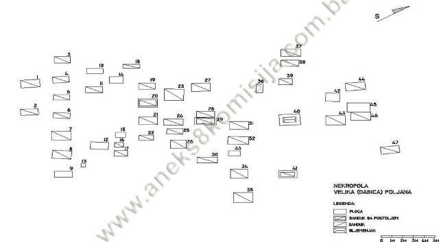
National Monument consists of a prehistoric tumulus and a necropolis with 47
stećak tombstones.
The
National Monument is located on a site designated as cadastral plot no. 1621,
Land Register entry no. 304, and part of c.p. no. 1622, Land Register entry no.
34, cadastral municipality Čičevo, Municipality Konjic, Federation of Bosnia
and Herzegovina, Bosnia and Herzegovina.
The
provisions relating to protection measures set forth by the Law on the
Implementation of the Decisions of the Commission to Preserve National
Monuments, established pursuant to Annex 8 of the General Framework Agreement
for Peace in Bosnia and Herzegovina (Official Gazette of the Federation of BiH
nos. 2/02, 27/02, 6/04 and 51/07) shall apply to the National Monument.
II
The
Government of the Federation of Bosnia and Herzegovina (hereinafter: the
Government of the Federation) shall be responsible for providing the legal,
scientific, technical, administrative and financial measures necessary for the
protection, conservation and presentation of the National Monument.
The
Commission to Preserve National Monuments (hereinafter: the Commission) shall
determine the technical requirements and secure the funds for preparing and
erecting signboards with basic details of the monument and the Decision to
proclaim the property a National Monument.
III
To ensure
the on-going protection of the National Monument, the following protection
measures are hereby stipulated, to apply to the site defined in Clause 1 para.
3 of this Decision, i.e. c.p. 1621 and part of c.p. 1622, an area defined by a
point at the centre of the tumulus X=4817649 Y=6502774 and a diameter of 20 m. The
following protection measures shall apply to this site:
-
all works are prohibited
other than conservation and restoration works, including those designed to
display the monument, with the approval of the Federal Ministry responsible for
regional planning (hereinafter: the relevant ministry) and under the expert
supervision of the heritage protection authority of the Federation of Bosnia and Herzegovina
(hereinafter: the heritage protection authority);
-
the site of the monument
shall be open and accessible to the public, and may be used for educational and
cultural purposes;
-
works on the
infrastructure are permitted with the approval of the relevant ministry and
subject to the expert opinion of the heritage protection authority;
-
the refurbishment of the
necropolis and repairs to any damage are permitted solely subject to first
drawing up a plan for repairs, restoration and conservation and to the approval
of the relevant ministry, and under the expert supervision of the heritage
protection authority;
-
the removal of lichen and
moss from the stećaks is prohibited;
-
by way of exception to the
above provision, the stećaks may be cleaned if required to examine the
epigraphic or decorative features of a stećak, subject to first compiling a
report and obtaining the approval of the entity ministry responsible for
regional planning. The report should be based on such biological, chemical,
physical and other analyses as a conservator considers necessary, and should
include appropriate conservation measures and an assessment of the impact of
cleaning methods on the stone;
-
the area is an
archaeological site, and investigative works must therefore be carried out in
the presence of an archaeologist;
-
a wooden fence up to 1.30
m in height shall be erected to the south-east of the necropolis as far as the
road and at a distance of 15 m from the stećaks;
-
a wooden fence up to 1.30
m in height shall be erected around the tumulus at a distance of 20 m;
-
the dumping of waste is
prohibited.
The
Government of the Federation shall be responsible in particular for ensuring
that the following measures are carried out:
-
conducting a geodetic
survey of the site;
-
drawing up a plan for
the repair, restoration, conservation and presentation of the National
Monument, which shall include:
-
archaeological
investigations of the site of the National Monument,
-
tidying the necropolis and
removing self-sown vegetation,
-
the routine maintenance of
the monument.
IV
All
movable artefacts found during the course of the archaeological survey shall be
deposited in the nearest museum able to provide the necessary personnel,
material and technical conditions or in the National Museum of Bosnia and
Herzegovina in Sarajevo,
processed, and suitably presented.
All
movable and immovable archaeological material found during the course of the
archaeological investigations shall be professionally processed.
Upon
completion of the archaeological works the archaeologist leading the
investigations shall submit a report to the Commission and to the institution
that conducted the investigations.
The
archaeologist leading the investigations must have access to all the movable
and immovable archaeological material found during the course of the
investigations and until his/her report is completed, for a period not
exceeding three years.
All
immovable finds shall be conserved in situ as the archaeological
investigations proceed, and the movable archaeological material shall be
conserved and placed for safe keeping in a suitable storage facility.
Upon
receipt of a report on the investigations conducted, the Commission shall
identify which movable artefacts shall be subject to protection measures to be
determined by the Commission.
The
removal of the movable artefacts referred to in para. 1 above from Bosnia and Herzegovina
is prohibited.
V
All
executive and area development planning acts are hereby revoked to the extent
that they are not in accordance with the provisions of this Decision.
VI
Everyone,
and in particular the competent authorities of the Federation of Bosnia and
Herzegovina, the Canton, and urban and municipal authorities, shall refrain
from any action that might damage the National Monument or jeopardize the
preservation thereof.
VII
The
Government of the Federation, the Federal Ministry responsible for regional
planning, the Federation heritage protection authority, and the Municipal
Authorities in charge of urban planning and land registry affairs, shall be
notified of this Decision in order to carry out the measures stipulated in
Articles II to V of this Decision, and the Authorized Municipal Court shall be
notified for the purposes of registration in the Land Register.
VIII
The
elucidation and accompanying documentation form an integral part of this
Decision, which may be viewed by interested parties on the premises or by
accessing the website of the Commission (http://www.kons.gov.ba)
IX
Pursuant
to Art. V para 4 Annex 8 of the General Framework Agreement for Peace in Bosnia and Herzegovina,
decisions of the Commission are final.
X
This
Decision shall enter into force on the day following its publication in the
Official Gazette of BiH.
This
Decision has been adopted by the following members of the Commission: Zeynep
Ahunbay, Martin Cherry, Amra Hadžimuhamedović, Dubravko Lovrenović and Ljiljana
Ševo.
No: 02-2-40/2009-11
11 March 2009
Sarajevo
Chair of
the Commission
Dubravko
Lovrenović
E l u c i
d a t i o n
I – INTRODUCTION
Pursuant
to Article 2, paragraph 1 of the Law on the Implementation of the Decisions of
the Commission to Preserve National Monuments, established pursuant to Annex 8
of the General Framework Agreement for Peace in Bosnia and Herzegovina, a
“National Monument” is an item of public property proclaimed by the Commission
to Preserve National Monuments to be a National Monument pursuant to Articles V
and VI of Annex 8 of the General Framework Agreement for Peace in Bosnia and
Herzegovina and property entered on the Provisional List of National Monuments
of Bosnia and Herzegovina (Official Gazette of BiH no. 33/02) until the
Commission reaches a final decision on its status, as to which there is no time
limit and regardless of whether a petition for the property in question has
been submitted or not.
On 6
March 2007 the Department of Administrative and Social Affairs and Inspection
of Konjic Municipality submitted a proposal/petition to designate the
necropolis of stećak tombstones at Dabića poljana, on the slopes of Mt. Bahtijevica,
as a national monument
of Bosnia and Herzegovina.
Pursuant
to the provisions of the law, the Commission proceeded to carry out the
procedure for reaching a final decision to designate the Property as a National
Monument, pursuant to Article V para. 4 of Annex 8 and Article 35 of the Rules
of Procedure of the Commission to Preserve National Monuments.
Statement of Significance
The
National Monument consists of 47 stećaks in a necropolis on the slopes of Mt. Bahtijevica,
close to the old road linking Bosnia
with the Adriatic coast, in an area rich in natural resources, particularly
mineral ores, upland pastures, forest and water. The mediaeval tombstones known
as stećaks are unique to Bosnia
and Herzegovina and its neighbours. They
provide impressive evidence of the growing economic power of Bosnian feudal
society in the 14th century, the opening of mines, increasing urbanization, and
the wish of individuals to display their status and power through the
appearance of their tombstones. They are thus of outstanding historical and
considerable cultural value.
The
stećaks at Velika poljana illustrate the three basic shapes of stećaks – slabs,
chests and gabled or sarcophagus-like – and demonstrate the quality of
workmanship and type of decorations typical of the stonemasons' workshops of Herzegovina. Nearby,
to the morth-east, is a stone tumulus, indicating continuity of habitation of
this site since prehistoric times.
II – PRELIMINARY PROCEDURE
-
details of the current
condition and use of the property, including a description, architectural
survey and photographs
-
an inspection of the
current state of the property
-
a copy of the cadastral
plan
-
a copy of the Land
Register entry
-
historical, architectural
and other documentary material on the property, as set out in the bibliography
forming part of this Decision
Pursuant
to Article V para. 2 of Annex 8 of the General Framework Agreement for Peace in
Bosnia and Herzegovina and Article 37 of the Rules of Procedure of the
Commission, before rendering a final decision designating a property as a
national monument, the Commission is required to provide the owner of the
proposed monument, the person submitting the petition, the institutions
responsible for heritage, professional and academic institutions, experts and
scholars, as well as other interested parties, to express their views. The
Commission received a petition, copy of cadastral plan, copy of Land Register
entry and 11 photographs under cover of letter ref. 09-42-3-411/07 of 2 March
2007 from the Department of Administrative and Social Affairs and Inspection of
Konjic Municipality.
Accordingly,
the Commission sent a letter ref. 02-32-53/07-4 of 14 November 2008 to the
Institute for the Protection of Monuments under the Federal Ministry of Culture
and Sport and the Federal Ministry of Regional Planning, requesting documentation
and views on the designation of the necropolis with stećak tombstones at Dabića
(Velika) poljana, on the slopes of Mt. Bahtijevica as a national monument of
Bosnia and Herzegovina.
In
response, the Commission has received the following documentation:
-
letters ref.
09-42-3-2451/08 and 09-42-3-2452/08 of 21 October 2008 supplying the cadastral
plan in digital form and a copy of the cadastral plan and Land Register entry
in print form;
-
letter ref.
03-23-2-1520/08 of 18 November 2008 from the Federal Ministry of Regional
Planning, notifying the Commission that it has no details or documentation
relating to the necropolis with stećak tombstones at Dabića (Velika) poljana,
on the slopes of Mt. Bahtijevica;
-
letter ref.
07-40-4-4434-1/08 of 26 November 2008 supplying the available information
previous listing and statutory protection of the necropolis with stećak tombstones
at Dabića (Velika) poljana, on the slopes of Mt. Bahtijevica;
-
letter ref. 09-42-3-411/08
of 24 November 2008 from the Department of Administrative and Social Affairs
and Inspection of Konjic Municipality supplying the Land Register entry for
c.p. no. 1621, c.m. Čičevo;
-
letter ref. 09-42-3-411/09
of 6 February 2009 from the Department of Administrative and Social Affairs and
Inspection of Konjic Municipality supplying a copy of the cadastral plan and
Land Register entry for c.p. no. 1622, c.m.
The findings
based on the review of the above documentation and the condition of the site
are as follows:
1. Details of the property
Location
The
plateau known as Velika (Dabića) poljana (velika poljana means a large field or
plot) is on the slopes of Mt Bahtijevica (alt. 1163 m, a spur of Mt. Prenj),
alongside the old or “Turkish” road leading from Ivan-planina (Mt. Ivan)
to Porim, between Lipeti and Zijemlje. Here, on a plot of land with an area of
1170 m², is a necropolis with 47 stećaks (eight slab-shaped, 30 chest-shaped,
eight tall chests, and one gabled). About 100 north of the necropolis with
stećaks, on c.p. no. 1622, is a prehistoric tumulus.
The
National Monument is located on a site designated as cadastral plot no. 1621,
Land Register entry no. 304, and part of c.p. no. 1622, Land Register entry no.
34, cadastral municipality Čičevo, Municipality Konjic, Federation of Bosnia
and Herzegovina, Bosnia and Herzegovina.
The plot
c.p. 1621 is in the sole ownership of the Glavatičevo local ward, and according
to the cadastral records Dabić Ilije Pero owns the right of disposal of plot
c.p. 1622.
Historical information(1)
The area
around the upper Neretva straddles two regions. Since prehistoric times, the
roads linking central Bosnia
with the Adriatic coast ran along the Neretva valley and its outer margins. With
some alterations and adaptations to the route, major roads ran here in
antiquity, mediaeval times and the Ottoman period, until the road was laid
through the Neretva gorge from Jablanica to the south in the 1880s. The central
Bosnian ore-rich mining area, the fertile soils of the Neretva valley, and the
rich mountain pastures, all led to the formation of many settlements throughout
history, in line with the conditions and demands of their respective times, on
the great bend in the Neretva between the mountain massifs of Bitovnja,
Bjelašnica and Visočica to the north, and Prenj and Čvrsnica to the south(2).
Roads
have always been an indicator of the way of life in a given area. For Konjic,
the natural route linking Hum land, its coastal regions and Dubrovnik
with central and northern Bosnia
and part of Pannonia
– a route where a road was laid in Roman times – was an important feature. Certain
documentation concerning major routes in mediaeval times preserves the name
''Vlaški put'' (Vlach road), relating for instances to part of the old road
from Zaborani to Glavatičevo. These Vlach roads, so called, in Herzegovina are
known to have been the routes taken by semi-nomadic herders, most of them of
Vlach origin(3) (P.
Anđelić, 1982, 90, 91).
The “Turkish
road” from Ivan-planina to Porim is one of the most difficult roads in Bosnia and Herzegovina,
on account of its steepness and the severe climate, with blizzards on Mts Ivan,
Lipeti and Bahtijevica often making the road completely impassable. It is part
of the old road linking southern Dalmatia and Herzegovina
with central Bosnia and,
beyond, with the Danube basin.
Archaeological
remains (hill forts and tumuli) show that there was a road here in prehistoric
times, by the 9th century BCE. The Romans laid a metalled road over much of the
route, which can still be followed from Vrabač to Lipeti. Milestones found in
Podorašac, Konjic, Perića Polje, Borci, Kula, and Mala poljana near Lipeti bear
the names of the Roman emperors Augustus, Decius, Tacitus and Phillipus
Augustus (Philip the Arab), indicating that work began on the road as soon as
Illyricum had been conquered in the 1st century, and that major reconstruction
works were carried out in the mid 3rd century CE. The Roman road that ran from Narona
(modern Vid near Metković) went through Dubrave and crossed the Nevesinje
plain, meeting the Turkish road from Ivan-planina to Porim at Velika poljana
near Lipeti. From Lipeti to Podorašac the Roman road and, later, the Turkish
road, largely followed the same route(4).
During
the Ottoman period in Bosnia and Herzegovina, the main road between the trading
centres of Sarajevo and Mostar branched off from the old Roman road
south-westwards from Lipeti (or, more exactly, Velika poljana) to run through
Gornje Zijemlje, Porim and Bijelo polje to Mostar. Watchtowers built to
safeguard the road have been found along the entire route. At Lipeti, the
remains of building materials from Roman fortifications have been found, as has
an Ottoman watchtower, where there was a well with drinking water and near
which were the huts of the people of Čičevo; this watchtower was at the highest
altitude (1143 m) and was the most remote from permanent habitations along the
entire route(5).
The
mediaeval tombstones of Bosnia
and Hum known as stećaks became the subject of scholarly interest in not
entirely favourable circumstances, hundreds of years after they had become a
relic of a historic age. At the turn of the 18th-19th century, the western
world began to hear of the unusual art to be found on tombstones in Bosnia and
Herzegovina and Dalmatia, initially from the accounts of travellers that were
not well documented enough to give rise to any significant interest in the
west, particularly since western scholarship was then occupied with the
analysis of entirely different works of art; as a result, the realistic, and
indeed clumsy scenes on the stećaks neither appealed to scholars nor aroused
their interest. In Ottoman Bosnia itself, there were no forces capable
independently of studying and presenting these treasures of mediaeval art(6). In these circumstances, by the
mid 19th century – when the process of modern national coalescence was in full
swing and the question of whom Bosnia belonged to increasingly took on
political and even apocalyptic significance – scholars were inclined to see the
art of the stećaks as having arisen from Bogomil teachings(7). Nor was there any lack of
efforts to give the stećaks a purely Serbian or Croatian national stamp(8).
From the
mid 20th century, the prevailing scholarly opinion was that the stećaks could
not be explained by either “bogomilization” or any exclusively national theory,
but rather than they should be situated in their own authentic world, the world
in which they came into being, evolved and then died out in the late 15th
century, after the mediaeval Bosnian state had itself come to an end(9).
2. Description of the property
According
to Š. Bešlagić’s statistics, Konjic municipality – with 3,018 recorded stećaks
– is one of those with the greatest number of stećaks in Bosnia and Herzegovina. In terms of
shape, chest-shaped stećaks are the most numerous, with gabled and slab-shaped
tombstones represented in almost equal numbers. The way in which the stećaks
are grouped makes it possible to trace and to document on the ground important
historical features, processes and relations. The siting of large necropolises
is a reliable indication of the centres of former religious and political
communities. That of medium-sized necropolises enables one to follow the
process of development of clan-based villages, while smaller groups reflect
intensive feudalization and social differentiation, when individual clans no
longer bury their dead alongside their neighbours, but form their own family
necropolises. The stećaks in the Konjic region can provide an important
contribution to resolving the question of the origin of stećaks, both in terms
of ethnicity and as regards the origins of their basic form. The Sanković
necropolis in Biskup is a striking example of the way in which, throughout the
14th century, stećaks were used as tombstones by the most powerful landowning
clan in the whole of Hum land, while the Bogopanci – Draživojevići – Sankovići
are indubitably of Slav origin and culture, not Vlach. It should be borne in
mind that by the 14th century the Vlachs already belonged to lower-class social
structures and were certainly not in a position to impose their customs, and in
particular the way in which graves were marked, on their overlords. The theory
of the Vlach origin of stećaks cannot be justified, even though there are
several necropolises in the Konjic area, and perhaps the finest at that, which
could be attributed to Vlachs.
The
decoration of stećaks began in the mid 14th century, continued throughout the
15th, and came to an end in the early 16th century. Circumstances such as the
geological composition of the rock from which stone was taken to make stećaks
no doubt influenced the finer shaping of the tombstones. The considerable
difference in the quality of workmanship of the stećaks in the Neretvica
valley, where there was no suitable stone, and that of the karst regions around
Glavatičevo and Bjelimići, is striking. It would seem, however, that this was
not the only reason for the differences, for the Jablanica area has good
material, and yet does not have any particularly evolved forms and decorations.
Among the influences from neighbouring districts that of southern Herzegovina
(old Hum) is particularly noticeable, as can be seen throughout the area to the
east of Konjic. In Bradina are low gabled stećaks clearly modelled on those of
neighbouring regions of central Bosnia.
The epitaphs on the stećaks are of particular value. They are written in
Bosnian Cyrillic script, and date from the late 14th and the early or the
second half of the 15th century(10).
P.
Anđelić found evidence of Vlach communities having lived on all the mountain
slopes where there was pasturage suitable for their livestock. One of these
communities in what is now Konjic municipality lived on the slopes of Mts
Bahtijevica and Crna Gora, ranging from the Boračko lake, Kula and Čičevo all
the way to the Nevesinje Plain, Zijemlje and Porim, as indicated by six
toponyms of uplands with the name Vlahinje (Mala Vlahinja, Velika Vlahinja).
The geographical location of the area where traces of Vlachs have been found in
Konjic municipality provides clear evidence that their basic occupation was
herding. The area with Vlach toponomastics reveals few traces of organized
townships, and evidence of feudal agrarian relations are also sparse in the
extreme: what is more, where there are signs of a township, Vlach place-names
are rare. The very fact that the Vlach toponomastics are associated with
specific areas suggests that these names could date from a time when Vlach
settlements had begun to become relatively permanent(11).
The
plateau known as Velika (Dabića) poljana is on the slopes of Mt Bahtijevica
(alt. 1163 m, a spur of Mt. Prenj), alongside the old or “Turkish” road leading
from Ivan-planina (Mt. Ivan) to Porim, between Lipeti and Zijemlje. Here, on a
plot of land with an area of 1170 m², is a necropolis with 47 stećaks (eight
slab-shaped, 30 chest-shaped, eight tall chests, and one gabled). The
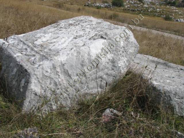
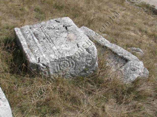
tombstones are of good workmanship, but not all that well preserved. Thirteen
are decorated with relief motifs: floral stylizations in the form of
symmetrical spirals, borders and friezes of scrolling vines, rope-twists,
“oyster-shell” concavities, crescent moons and circular garlands. There are
also figural scenes of deer and a foot combat scene.
About
1,000 to 1,500 m south of Velika poljana, close to Glogovčeve kolibe (huts),
Pavao Anđelić found a group of seven stećaks (four chests and three slabs),
lying west-east, and of good workmanship. One slab was decorated with a cross(12). Šefik Bešlagić also noted a
number of small stone tumuli near the necropolis(13).
This
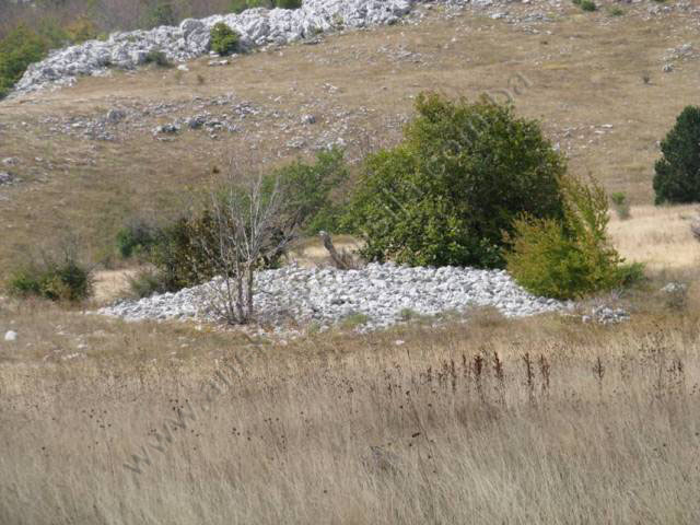
Decision also pertains to a prehistoric grave mound or tumulus. This is located
on the plot designated as c.p. 1622, 100 m north of the necropolis with
stećaks. It occupies an area with a diameter of 29.58 m, is about 1.10 m in height,
and has a circumference of 92.91 m and an area of 687.31 sq.m. The lower parts
of the tumulus, nearer the ground, are covered with grass, and the mound is
surrounded by brambles, various plants and even sizeable trees. Apart from the
stones laid in a circle at the top of the mound, there are no visible remains
of a the grave.
Condition of the stećaks
Stećak
no. 1. – chest with decoration, covered with lichens and overgrown with
grass, damaged at the north-east end, lying south-west/north-east; the stećak
measures 177x86x48 cm.
There is
a round, concave “oyster-shell” in the middle of the top of the stećak.
Stećak
no. 2. – chest without decoration, covered with lichens and moss and
overgrown with grass, lying south-west/north-east; the stećak measures
163x70x61 cm.
Stećak
no. 3. – chest without decoration, covered with lichens and moss and
overgrown with grass and thorny scrub, lying south-west/north-east; the stećak
measures 151x73x28 cm.
Stećak
no. 4. – chest with decoration, covered with lichens and moss and
overgrown with grass, lying south-west/north-east; the stećak measures
157x68x35 cm.
There is
a round, concave “oyster-shell” at the south-west end of the top of the stećak.
Stećak
no. 5. – chest without decoration, covered with lichens and moss and
overgrown with grass, lying south-west/north-east; the stećak measures 151x62x35
cm.
Stećak
no. 6. – chest without decoration, covered with lichens and moss and
overgrown with grass, partly buried on the south-east side, lying
south-west/north-east; the stećak measures 158x125x62 cm.
Stećak
no. 7. – chest with decoration, covered with lichens and moss and
overgrown with grass, partly buried, lying south-west/north-east; the stećak
measures 184x99x27 cm.
A
recessed line runs the full length of the stećak, dividing it into two.
Stećak
no. 8. – tall chest without decoration, covered with lichens and moss
and overgrown with grass, lying south-west/north-east; the stećak measures
178x89x96 cm.
Stećak
no. 9. – slab without decoration, covered with lichens and moss and
overgrown with grass, partly buried, lying south-west/north-east; the stećak
measures 128x37x10 cm.
Stećak
no. 10. – slab without decoration, covered with lichens and moss and
overgrown with grass, partly buried, lying south-west/north-east; the stećak
measures 154x57x12 cm.
Stećak
no. 11. – chest without decoration, covered with lichens and moss and
overgrown with grass, lying south-west/north-east; the stećak measures
162x70x44 cm.
Stećak
no. 12. – slab without decoration, covered with lichens and moss and
overgrown with grass and low-growing plants, lying south-west/north-east; the
stećak measures 168x78x20 cm.
Stećak
no. 13. – part of a stećak that is almost completely buried, covered with
lichens and moss and overgrown with grass; the stećak measures 42 cm long x 50
cm wide.
Stećak
no. 14. – slab without decoration, covered with lichens and moss and
overgrown with grass, partly buried, lying south-west/north-east; the stećak
measures 128x70x24 cm.
Stećak
no. 15. – slab without decoration, partly buried, covered with lichens
and moss and overgrown with grass, lying south-west/north-east; the stećak
measures 93x57x12 cm.
Stećak
no. 16. – chest without decoration, covered with lichens and moss and
overgrown with grass, damage to the north-west side of the top, lying
south-west/north-east; the stećak measures 86x56x10 cm.
Stećak
no. 17. – chest with decoration, covered with lichens and moss and
overgrown with grass, lying south-west/north-east; the stećak measures
125x64x33 cm.
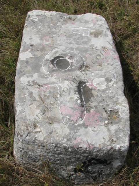
The
north-eastern end of the top surface bears a rare decoration in the form of a
cross with, instead of the top upright, has a circle, which Š. Bešlagić saw as
“reminiscent of the ancient Egyptian hieroglyph of the ankh (crux ansata), or
the Coptic ideogram for Christ” (Š. Bešlagić, 1982, 186). The decoration is in
relief, with the middle of the circle in reverse relief forming a concavity.
Stećak
no. 18. – chest with decoration, with a crudely worked top surface,
covered with lichens and moss and overgrown with grass, partly buried, lying
south-west/north-east; the stećak measures 157x44x74 cm.
The south-west
end bears a decoration which, though hard to make out because the stećak is
partly buried, appears to be a floral stylization in the form of symmetrical
spirals.
Stećak
no. 19. – chest without decoration, with visible cracks at the north-east
end, covered with lichens and moss and overgrown with grass, lying
south-west/north-east; the stećak measures 152x70x20 cm.
Stećak
no. 20. – tall chest with plinth, without decoration, visible damage to
the south-west end, partly buried and leaning up against stećak no. 21 to the
south-east, covered with lichens and moss and overgrown with grass, lying
south-west/north-east; the stećak measures 154x66x102 cm; the plinth measures
180x93x20 cm.
Stećak
no. 21. – tall chest without decoration, covered with lichens and moss
and overgrown with grass, partly buried to the north-west and leaning up
against stećak no. 20, lying south-west/north-east; the stećak measures 172 x
88 (width at the base 79) x 80 cm.
Stećak
no. 22. – chest without decoration, covered with lichens and moss and
overgrown with grass, partly buried, lying south-west/north-east; the stećak
measures 137x57x34 cm.
Stećak
no. 23. – chest with decoration, covered with lichens and moss and
overgrown with grass and thorny scrub, lying south-west/north-east; the stećak
measures 180x130x30 cm.
A
recessed line runs the full length of the stećak, dividing it into two.
Stećak
no. 24. – chest without decoration, covered with lichens and moss and
overgrown with grass, partly buried, lying south-west/north-east; the stećak
measures 176x74x60 cm.
Stećak
no. 25. – slab without decoration, covered with lichens and moss and
overgrown with grass, partly buried, lying south-west/north-east; the stećak
measures 150x60x12 cm.
Stećak
no. 26. – chest without decoration, of crude workmanship, covered with
lichens and moss and overgrown with grass, lying south-west/north-east; the
stećak measures 146x93x46 cm.
Stećak
no. 27. – tall chest without decoration, partly buried, covered with
lichens and moss and overgrown with grass, lying south-west/north-east; the
stećak measures 176x90x60 cm.
Stećak
no. 28. – chest without decoration, partly buried, covered with lichens
and moss and overgrown with grass, leaning up against stećak no. 29 to the
south-east, lying south-west/north-east; the stećak measures 166x69x90 cm.
Stećak
no. 29. – tall chest with plinth and decoration, covered with lichens and
moss and overgrown with grass, partly buried to plinth height and leaning up
against stećak no. 28 to the north-west, lying south-west/north-east; the
stećak measures 167x62x102 cm; the plinth is 205 cm in length.
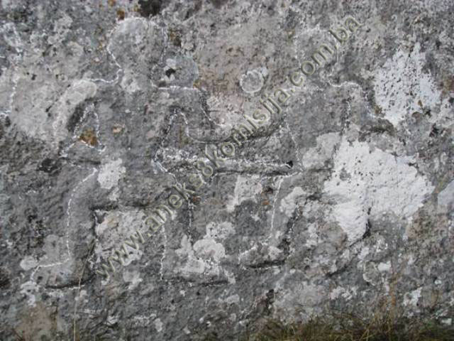
The
south-east end bears a figural scene of two swordsmen engaged in foot combat. Similar
scenes were recorded by Šefik Bešlagić on another eight stećaks in Bosnia and Herzegovina(14).
Stećak
no. 30. – chest without decoration, partly buried, covered with lichens
and moss and overgrown with grass, lying south-west/north-east; the stećak
measures 180x50x55 cm.
Stećak
no. 31. – chest with decoration, partly buried, covered with lichens and
moss and overgrown with grass, lying south-west/north-east; the stećak measures
175x89x40 cm.
There is
a round, concave “oyster-shell” in the middle of the top of the stećak. Unlike
the previous two instances of this decoration, this one is of good workmanship
and surrounded by a rope-twist border.
Stećak
no. 32. – tall chest with decoration, covered with lichens and moss and
overgrown with grass, damaged and cracked, lying south-west/north-east; the
stećak measures 190x89x105 cm.
The
south-west end bears a decoration of a double spiral, of which the stem ends at
the top in a rosette. The north-west corner of the end of the tombstone bears a
crescent moon, and the south-east corner a circular garland.
Stećak
no. 33. – slab without decoration, of crude workmanship and with visible
cracks, covered with lichens and moss and overgrown with grass, lying
south-west/north-east; the stećak measures 110x60x10 cm.
Stećak
no. 34. – chest without decoration, with visible cracks, covered with
lichens and moss and overgrown with grass, partly buried, lying
south-west/north-east; the stećak measures 160x100x40 cm.
Stećak
no. 35. – chest without decoration, covered with lichens and moss and
overgrown with grass, lying south-west/north-east; the stećak measures 180x112x56
cm.
Stećak
no. 36. – chest without decoration, partly buried, covered with lichens
and moss and overgrown with grass, lying north-south; the stećak measures
100x64x30 cm.
Stećak
no. 37. – chest without decoration, covered with lichens and moss and
overgrown with grass, partly buried on the north-west side, lying
south-west/north-east; the stećak measures 186x80x68 cm.
Stećak
no. 38. – chest without decoration, covered with lichens and moss and
overgrown with grass, partly buried, lying south-west/north-east; the stećak
measures 167x67x35 cm.
Stećak
no. 39. – chest without decoration, covered with lichens and moss and
overgrown with grass, lying south-west/north-east; the stećak measures
126x70x34 cm.
Stećak
no. 40. – gabled with plinth and decoration, covered with lichens and
moss and overgrown with grass, overturned onto its north-west side and partly
buried, the plinth is distinctive in that it was slightly hollowed out to take
the stećak, lying south-west/north-east; the stećak measures 120x120x56 cm; the
plinth measures 195x124x30 cm.
A frieze
of scrolling vines runs along the sides and ends below the roof panes, and the
edges are finished in the form of a border. Both ends bear the same decoration
– motifs of a stylized tree with rosettes in the gable. The south-east side
bears the isolated figure of a deer(15).
Stećak
no. 41. – tall chest with plinth and decoration, covered with lichens and
moss and overgrown with grass, overturned onto its north-west side and partly
buried, the plinth is distinctive in that, by comparison with the previous
plinth, it had a more pronounced, more even concavity to take the stećak, lying
south-west/north-east; the stećak measures 130 cm in length; the plinth
measures 170x80x43 cm.
A frieze
of scrolling vines runs along the sides and ends below prominent top edges,
which are finished in the form of a border. A decoration consisting of a border
of diagonal lines runs the length of the tombstone below the frieze. Both ends
bear a decoration of floral stylization in the form of symmetrical spirals.
Stećak
no. 42. – slab without decoration, of crude workmanship and partly
buried, covered with lichens and moss and overgrown with grass, lying
south-west/north-east; the stećak measures 130 cm long x 95 cm wide.
Stećak
no. 43. – chest without decoration, partly buried, covered with lichens
and moss and overgrown with grass, lying south-west/north-east; the stećak
measures 182x106x37 cm.
Stećak
no. 44. – chest with decoration and visible cracks, partly buried,
covered with lichens and moss and overgrown with grass, lying
south-west/north-east; the stećak measures 183x89x36 cm.
A frieze
of scrolling vines runs along the sides and ends below the top.
Stećak
no. 45. – tall chest without decoration, covered with lichens and moss
and overgrown with grass, leaning up against stećak no. 46 to the south-east,
lying south-west/north-east; the stećak measures 212x105x152 cm.
Stećak
no. 46. – chest without decoration, partly buried, covered with lichens
and moss and overgrown with grass, lying south-west/north-east; the stećak
measures 183x93x98 cm.
Stećak
no. 47. – chest with decoration, partly buried, covered with lichens and
moss and overgrown with grass, lying south-west/north-east; the stećak measures
173x81x68 cm.
The top
bears a frieze of scrolling vines along the edges of the stećak.
3. Legal status to date
The
Regional Plan for BiH to 2000 lists 69 sites of necropolises with stećaks
(3,018 tombstones) in Konjic
Municipality, without
precise identification(16).
The
letter from the Institute for the Protection of Monuments of the Federal
Ministry of Culture and Sport dated 26 November 2008, states that the property
is listed as “Necropolis with stećaks, Bahtijevica I, at Velika poljana, Konjic
Municipality, mediaeval necropolis (about 55 stećaks)” but was not on the
Register of cultural monuments of the Socialist Republic of Bosnia and
Herzegovina.
4. Research and conservation and
restoration works
Research
works, in the form of recording and gathering information on the stećaks, were
carried out by Pavao Anđelić and published in 1975.
No
conservation or restoration works have been carried out.
5. Current condition of the
property
The
findings of on-site inspections conducted on 24 September 2008, 3
February 2009 and 30 November 2012 are as follows:
-
the lower parts of the
tumulus, nearer the ground, are covered with grass, and the mound is surrounded
by brambles, various plants and even sizeable trees. The tumulus is 100 m north
of the necropolis,
-
the tumulus and stećaks
are at risk of rapid deterioration from lack of maintenance,
-
some of the stećaks are
chipped, damaged, overturned or partly buried,
-
the site where the stećaks
are located is on a plot that is not fenced off, which enables the local
residents to use the plot to as grazing for their livestock,
-
lichens and moss are
present on the stećaks to a greater or lesser extent,
-
for the most part the tops
of the stećaks (chests and slabs) are damaged to a greater or lesser extent
(cracks, splits),
-
during the second visit to
the site, graffiti (spray-painted names) were found on two of the stećaks;
these were not present during the first on-site visit,
-
during the third site
visit, the protection zone for the prehistoric tumulus was defined.
6. Specific risks
-
vandalism (overturning the
stećaks and graffiti),
-
deterioration of the
necropolis and tumulus as a result of long-term neglect,
-
adverse weather
conditions,
-
self-sown vegetation.
III – CONCLUSION
Applying
the Criteria for the adoption of a decision on proclaiming an item of property
a national monument (Official Gazette of BiH nos. 33/02 and 15/03), the
Commission has enacted the Decision cited above.
The
Decision was based on the following criteria:
A. Time frame
B. Historical value
C. Artistic and aesthetic value
C.i. quality of workmanship
C.ii. quality of materials
C.iii. proportions
C.v. value of details
D. Clarity
D.i. material evidence of a lesser known
historical era
G. Authenticity
G.i. form and design
G.ii. material and content
G.iv. traditions and techniques
The following
documents form an integral part of this Decision:
-
Ownership documentation
-
copy of cadastral plan,
plan no. Čičevo 19, scale 1:2500, for c.p. nos. 1621 and 1622, c.m. Čičevo, Konjic Municipality,
dated 21 July 2007 and 5 February 2009;
-
Land Register entry no.
34, c.m. Čičevo, Konjic, NAR and Rz no. 377/09, dated 5 February 2009
-
Documentation on previous
protection of the property
-
letter ref.
03-23-2-1520/08 of 18 November 2008 from the Federal Ministry of Regional
Planning, notifying the Commission that it has no details or documentation
relating to the necropolis with stećak tombstones at Dabića (Velika) poljana, on
the slopes of Mt.
Bahtijevica
-
letter ref.
07-40-4-4434-1/08 of 26 November 2008 supplying the available information
previous listing and statutory protection of the necropolis with stećak
tombstones at Dabića (Velika) poljana, on the slopes of Mt. Bahtijevica
-
Photodocumentation
-
photographs of the
property taken on 24 September 2008, 3 February 2009 and 30 November 2012 by
historian Zijad Halilović and historian Eldin Hodžić using Canon EOS 450D
digital camera
-
Technical documentation
-
technical survey of the
state of the property (survey of the monuments) conducted on 22 October 2011;
stećaks measured and recorded by Zijad Halilović, historian, and Nermina
Katkić, BSc.Arch. Ešref Salihagić, surveyor and freelance associate of the
Commission, submitted the defined protection zone on 4 December 2012.
Bibliography
During
the procedure to designate the property as a national monument of Bosnia
and Herzegovina the following works were
consulted:
1924. Glušac, Vaso. “Srednjovekovna ‘bosanska crkva’,” in: Prilozi
za književnost, jezik, istoriju i folklor, IV (The mediaeval “Bosnian Church”, in Contributions to Literature,
Language, History and Folklore, IV. Belgrade:
1924.
1963. Benac, Alojz. Stećaks. Belgrade: Prosveta, 1963.
1975. Anđelić, Pavao. Historijski spomenici Konjica i okoline
(Historic monuments of Konjic and its environs), I. Konjic: 1975.
1980. Various authors. Regional Plan for Bosnia and Herzegovina; Stage B -
valorization of natural, cultural and historical monuments. Sarajevo: Institute for architecture, town planning and
regional planning of the Faculty of Architecture in Sarajevo, 1980, 51.
1982. Bešlagić, Šefik. Stećaks. Kultura i umjetnost (Stećak
tombstones – culture and art). Sarajevo:
Veselin Masleša, 1982.
1990. Südland, L. V. (Ivo Pilar). Južnoslavensko pitanje. Prikaz
cjelokupnog pitanja. Varaždin (The Yugoslav Question. Full account of the
issue, Varaždin). Title of original: L. v. SÜDLAND, Die Südslawische Frage und der Weltkrieg. Übersichtliche Darstellung des
Gesamt-Problems. Wien: 1990.
(1) For more see
the Commission’s Decision designating the historic site of the necropolis
with stećaks at Gajine in Glavatičevo, Konjic
Municipality, as a national monument of Bosnia
and Herzegovina, no. 02-02-264/08-5 of 5
November 2008 (Official Gazette of BiH no. 12/09)
(2) The historical
information section has been taken from the Decision designating the
Archaeological Monuments in the Park at Varda below the Social Centre in Konjic
as a National Monument
(3) Anđelić, Dr.
Pavao, "Teritorijalnopolitička organizacija srednjovjekovne župe Neretve i
njezino mjesto u širim političkim okvirima" in Studije o
teritorijalnopolitičkoj organizaciji srednjovjekovne Bosne, Sarajevo: 1982, 90, 91
(4) Anđelić, Dr.
Pavao, Historijski spomenici Konjica i okoline, I, Konjic: Skupština
opštine Konjic, 1975, 169.
(5) Anđelić, Dr.
Pavao, Ibidem, Konjic: Skupština opštine Konjic, 1975, 171, 172 and 174.
(6) Benac,
Alojz, Stećaks, Beograd: Prosveta,
1963, 5
(7) Benac,
Alojz, Stećaks, Beograd: Prosveta,
1963, 19
(8) Glušac,
Vaso, “Srednjovekovna ‘bosanska crkva’,” in Prilozi za književnost, jezik,
istoriju i folklor, IV., Beograd: 1924, 31.-35.,
36.-37., 50; Südland, L. V. (Ivo Pilar), Južnoslavensko pitanje. Prikaz
cjelokupnog pitanja, Varaždin. Original title: L. v. SÜDLAND, Die
Südslawische Frage und der Weltkrieg. Übersichtliche Darstellung des Gesamt-Problems, Wien: 1990, 95, 96.
(9) The world
of Bosnia's and Hum's stećaks abounds in symbolism, full of crosses, crescent
moons, solar discs, swastikas and stars, scenes of the round dance,
tournaments, cavalry processions, military weapons, shields and arcades, vines
and bunches of grapes, stylized fleur de lis and rosettes, deer and wild
boar, coats of arms, swords and spears, portraits of the deceased with a
disproportionately large raised hand, books, roofs and representations of
houses.
(10) Anđelić,
Dr. Pavao, Ibidem, Konjic: Skupština opštine Konjic, 1975, 223-225.
(11) P. Anđelić
and Š. Bešlagić recorded 55 stećaks at this site (47 chests, 7 slabs and one
gabled), of which 10 chests and the one gabled stećaks were decorated. (P.
Anđelić, 1975, 197; Š. Bešlagić, 1971, 335).
(12) Anđelić, Dr.
Pavao, Ibidem, Konjic: Skupština opštine Konjic, 1975, 185
(13) Bešlagić,
Šefik, Stećci, kataloško-topografski pregled, Sarajevo, 1971, 335.
(14) Bešlagić,
Šefik, Stećci – kultura i umjetnost, Sarajevo, 1982, 341-343
(15) Since the
stećak was overturned and lying on the other (north-west) side, it was
impossible to see if that side was decorated.
(16) Various
authors, Prostorni plan Bosne i Hercegovine, faza b – valorizacija, prirodne
i kulturno-historijske vrijednosti, Sarajevo:
Institut za arhitekturu, urbanizam i prostorno planiranje Arhitektonskog
fakultet u Sarajevu i Urbanistički zavod za Bosnu i Hercegovinu Sarajevo, 1980,
51.