Status of monument -> National monument
Published in the “Official Gazette of BiH” no. 36/09.
Pursuant to Article V para. 4 Annex 8 of the General Framework Agreement for Peace in Bosnia and Herzegovina and Article 39 para. 1 of the Rules of Procecure of the Commission to Preserve National Monuments, at a session held from 10 to 16 March 2009 the Commission adopted a
D E C I S I O N
I
The historic site of the necropolis with stećak tombstones at Omeđak in the village of Sudići, Municipality Čajniče, is hereby designated as a National Monument of Bosnia and Herzegovina (hereinafter: the National Monument).
The National Monument consists of a necropolis with six stećak tombstones.
The National Monument is located on a site designated as cadastral plot nos. 13/133 and 13/134, title deed no. 24, cadastral municipality Batovo, Municipality Čajniče, Republika Srpska, Bosnia and Herzegovina.
The provisions relating to protection measures set forth by the Law on the Implementation of the Decisions of the Commission to Preserve National Monuments, established pursuant to Annex 8 of the General Framework Agreement for Peace in Bosnia and Herzegovina (Official Gazette of Republika Srpska no. 9/02, 70/06 and 64/08) shall apply to the National Monument.
II
The Government of Republika Srpska shall be responsible for providing the legal, scientific, technical, administrative and financial measures necessary for the protection, conservation and presentation of the National Monument.
The Commission to Preserve National Monuments (hereinafter: the Commission) shall determine the technical requirements and secure the funds for preparing and setting up signboards with basic details of the monument and the Decision to proclaim the property a National Monument.
III
To ensure the on-going protection of the National Monument on the site defined in Clause 1 para. 3 of this Decision, the following protection measures shall apply:
- all works are prohibited other than conservation and restoration works and routine maintenance works, including works designed to display the monument, with the approval of the ministry responsible for regional planning in Republika Srpska (hereinafter: the relevant ministry) and under the expert supervision of the heritage protection authority of Republika Srpska (hereinafter: the heritage protection authority);
- the site of the monument shall be open and accessible to the public, and may be used for educational and cultural purposes;
- infrastructure works shall be permitted only with the approval of the relevant ministry and subject to the expert opinion of the heritage protection authority;
- the dumping of waste is prohibited.
The Government of Republika Srpska shall be responsible in particular for implementing the following measures:
- conducting a geodetic survey of the condition of the National Monument;
- drawing up a project for the repair, restoration and conservation of the necropolis.
The repair, restoration and conservation project shall cover:
- archaeological investigations;
- clearing the monuments of lichen and moss and making good any damage;
- tidying the necropolis and removing self-sown vegetation;
- erecting a fence around the site and installing benches, litter bins, signposts, directional arrows etc;
- drawing up and implementing a programme for the conservation and presentation of the National Monument.
IV
All executive and area development planning acts not in accordance with the provisions of this Decision are hereby revoked.
V
Everyone, and in particular the competent authorities of Republika Srpska and urban and municipal authorities, shall refrain from any action that might damage the National Monument or jeopardize the preservation thereof.
VI
The Government of Republika Srpska, the Ministry responsible for regional planning in Republika Srpska and the heritage protection authority of Republika Srpska, and the Municipal Authorities in charge of urban planning and land registry affairs, shall be notified of this Decision in order to carry out the measures stipulated in Articles II – V of this Decision, and the Authorized Municipal Court shall be notified for the purposes of registration in the Land Register.
VII
The elucidation and accompanying documentation form an integral part of this Decision, which may be viewed by interested parties on the premises or by accessing the website of the Commission (http://www.aneks8komisija.com.ba)
VIII
Pursuant to Art. V para 4 Annex 8 of the General Framework Agreement for Peace in Bosnia and Herzegovina, decisions of the Commission are final.
IX
This Decision shall enter into force on the day following its publication in the Official Gazette of BiH.
This Decision has been adopted by the following members of the Commission: Zeynep Ahunbay, Martin Cherry, Amra Hadžimuhamedović, Dubravko Lovrenović, and Ljiljana Ševo.
No: 02-2-40/09-13
11 March 2009
Sarajevo
Chair of the Commission
Dubravko Lovrenović
E l u c i d a t i o n
I – INTRODUCTION
Pursuant to Article 2, paragraph 1 of the Law on the Implementation of the Decisions of the Commission to Preserve National Monuments, established pursuant to Annex 8 of the General Framework Agreement for Peace in Bosnia and Herzegovina, a “National Monument” is an item of public property proclaimed by the Commission to Preserve National Monuments to be a National Monument pursuant to Articles V and VI of Annex 8 of the General Framework Agreement for Peace in Bosnia and Herzegovina and property entered on the Provisional List of National Monuments of Bosnia and Herzegovina (Official Gazette of BiH no. 33/02) until the Commission reaches a final decision on its status, as to which there is no time limit and regardless of whether a petition for the property in question has been submitted or not.
On 26 November 2007, Samija Šabanović, a member of the Sinan Pasha Sijerčić Society for the preservation of nature and the civilizational heritage of Goražde, submitted a proposal/petition to designate the Omeđak necropolis of stećak tombstones in Sudići, Municipality Čajniče, as a national monument of Bosnia and Herzegovina.
Pursuant to the provisions of the law, the Commission proceeded to carry out the procedure for reaching a final decision to designate the Property as a National Monument, pursuant to Article V of Annex 8 and Article 35 of the Rules of Procedure of the Commission to Preserve National Monuments.
Statement of Significance
Stećci (pl. of stećak) are a distinct phenomenon and a highly specific synthesis of language and script, religion and customs, history and chronology, culture, art and aesthetics. They are mainly associated with the mediaeval regions of Bosnia and Hum, and it is hard, or indeed impossible, to find any similar feature that has so strikingly marked the cultural landscape of any mediaeval European country. In Europe as a whole, they are distinctive on account of their numbers and the fact that they were common to all the faiths of the region where they are found, a genuine multicultural phenomenon in the history of Bosnia and Herzegovina. Their origins and evolution may be traced from the mid 12th to the early 16th century.
The necropolis at Omeđak in the village of Sudići, Municipality Čajniče, consists of six chest-shaped stećci, the top of one of which is decorated with a swastika.
II – PROCEDURE PRIOR TO DECISION
In the procedure preceding the adoption of a final decision to proclaim the property a national monument, the following documentation was inspected:
- Documentation on the location and current owner and user of the property (copy of cadastral plan and copy of land registry entry);
- Data on the current condition and use of the property, including a description and photographs, data of war damage, data on restoration or other works on the property, etc;
- Historical, architectural and other documentary material on the property, as set out in the bibliography forming part of this Decision.
The findings based on the review of the above documentation and the condition of the site are as follows:
1. Details of the property
Location
Sudići is a village about 15 km to the north of Čajniče. The necropolis, consisting of six stećci, is below the village, on a hillock known as Omeđak. The local people call the area where the necropolis is located Tinjak.
The National Monument is located on a site designated as cadastral plot nos. 13/133 and 13/134, title deed no. 24, cadastral municipality Batovo, Municipality Čajniče, Republika Srpska, Bosnia and Herzegovina. These plots appear to be equivalent to c.p. no. 3173 or to the adjoining unnumbered plot on an Austro-Hungarian topographical map.
Historical information
Nothing is known of Čajniče at the time of the mediaeval Bosnian state. The entire area was in the upper Drina valley, which was within the borders of the Serbian state until 1377, when it became part of Bosnia after King Tvrtko I Kotromanić of Bosnia and Prince Lazar of Serbia defeated Nikola Altomanović in battle and divided up his lands. From the end of the 14th century, the area was ruled by Bosnia's Sandalj Hranić (1396-1343) and herceg (duke) Stjepan Vukčić Kosača (1434-1466). Various documents in the archives of Dubrovnik dating from this time contain records of trade, artisanal and transit activities in Foča, Goražde and Ustikolina. Richly forested and with fertile valleys, the area was well suited to the development of animal husbandry, bee-keeping, the cultivation of grain crops and other agricultural produce. Though there are no references to Čajniče itself in mediaeval historical records, the wealth of archive material from that period relating to the upper Drina valley, the many necropolises with stećci, local traditions and the earliest Ottoman sources all attest to this being a quite densely inhabited area (Đ. Petrović, 1973, 38-42). Though Čajniče is not named in mediaeval sources, it was already a market town when the Ottomans came to the region (D. Kovačević-Kojić, 1978, 87).
Čajniče was taken during the Ottoman offensive that began in the summer of 1465 in the Herceg's lands. First to fall were the eastern parts of his lands, including the forts of Mileševac and Samobor (Vego, 1957, 28, 97; Šabanović, 1982, 44). Čajniče and Samobor were recorded along with other nahijas (minor administrative entities) and places in the area: Pljevlja, Foča, Goražde, Bistrica with Ustikolina, Osanica and so on, in the defter [official records] of 1468/69 in the nahija of Samobor, in the Hercek Vilajet in the Bosnian sandžak. The nahija of Samobor or Pribud is referred to by its double name until the 18th century. This same defter refers to Čajniče as “in the nahija of Samobor, the Čajniče market,” listed as an imperial khas with an iron mine, six forges and 415 smelting furnaces. The 1477 defter lists Čajniče as an imperial khas with 190 households and five bachelor households. The nahija belonged to the Drina kadiluk [area under the jurisdiction of a qadi, an Islamic judge and administrative officer], but in 1572 Čajniče was referred to as a kasaba [small town] in the Foča kadiluk. In 1582 it became an independent kadiluk in its own right, to which the nahijas of Pribud and Samobor (previously a single nahija) belonged, along with Dubštica (with its centre in Rudo) and Međurječje (Šabanović, 117, 136, 139, 195).
In mediaeval times, the main road through this region was the Via Drinae, and Foča and Goražde were its principal towns. In the Ottoman period, the road from Bosnia to Istanbul ran through Čajniče. Judging from the 1573 account by the French traveller Philippe Dufresne Canaye and Evliya Çelebi's 1664 account, Čajniče was a wealthy town (Dinić, 1940, 99; Čelebija, 1979, 399-403).
The mediaeval tombstones of Bosnia and Hum known as stećci became the subject of scholarly interest in not entirely favourable circumstances, hundreds of years after they had become a relic of a historic age. At the turn of the 18th-19th century, the western world began to hear of the unusual art to be found on tombstones in Bosnia and Herzegovina and Dalmatia, initially from the accounts of travellers that were not well documented enough to give rise to any significant interest in the west, particularly since western scholarship was then occupied with the analysis of entirely different works of art; as a result, the realistic, and indeed clumsy scenes on the stećci neither appealed to scholars nor aroused their interest. In Ottoman Bosnia itself, there were no forces capable independently of studying and presenting these treasures of mediaeval art (A. Benac, 1963, XVII, XXIX). In these circumstances, by the mid 19th century – when the process of modern national coalescence was in full swing and the question of whom Bosnia belonged to increasingly took on political and even apocalyptic significance – scholars were inclined to see the art of the stećci as having arisen from Bogomil teachings (A. Benac, 1963, XXIX). Nor was there any lack of efforts to give the stećci a purely Serbian or Croatian national stamp (V. Glušac, 1924, 31-35, 36-37, 50; Südland, 1990, 95, 96). From the mid 20th century, the prevailing scholarly opinion was that the stećci could not be explained by either “bogomilization” or any exclusively national theory, but rather than they should be situated in their own authentic world, the world in which they came into being, evolved and then died out in the late 15th century, after the mediaeval Bosnian state had itself come to an end(1).
2. Description of the property
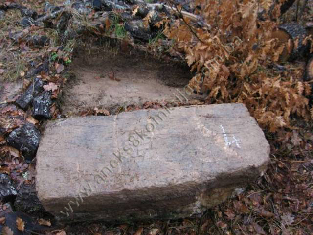
The steep road to Sudići, which is passable only with a four-wheel-drive vehicle, forks off to the right from the main Čajniče to Ustiprača road along the Janjina river valley at Kapov han, about 100 m after the school. The necropolis with stećci is at Omeđak, belopw the village of Sudići(2). Though the petition to designate the stećci as a national monument refers to 15 to 20 tombstones, only six were found during the on site visit.
The stećci lie west-east and north-south. The top of stećak no. 4, which was moved from its original position when the local road was built, is decorated with a swastika(3). Stećak no. 3 is fully sunken into the driveway leading to one of the houses, and the other stećci lie on both sides of the road, partly buried and half-hidden by shrubs.
Condition of the stećci:
Stećak no.1 – chest-shaped, undecorated, lying west-east, covered with moss and overgrown with weeds, measuring 205 x 74 x 12 cm;
Stećak no. 2 – chest-shaped, undecorated, lying west-east, covered with moss and overgrown with weeds, measuring 210 x 77 c 30 cm;
Stećak no. 3 – chest-shaped, undecorated, lying west-east, fully sunken into the road, measuring 200 cm long x 67 cm wide;
Stećak no. 4 – chest-shaped, without plinth, decorated, lying north-south, originally upside down, but during the survey of the site we set it upright to identify the decoration. The stećak measures 96 x 44 x 44 cm. The decoration, a swastika in reverse relief, is in the middle of the top surface.
Stećak no. 5 – chest-shaped, without plinth, undecorated, lying north-south, almost completely buried, making it impossible to study it fully. The visible width is 65 cm and height 15 cm;
Stećak no. 6 – chest-shaped, without plinth, undecorated, lying west-east, covered with moss and overgrown with weeds. Its position suggests that it has been moved from its original location. The stećak measures 72 x 35 x 20 cm.
3. Legal status to date
During the procedure prior to the adoption of a final decision on designation, the records of protection of the property were inspected, and the findings are as follows:
The Regional Plan for BiH to 2000 lists eight sites of necropolises with stećci (a total of 518 stećci) in Čajniče Municipality, without identifying them in detail (Various authors, 1980, p. 51).
4. Research and conservation and restoration works
No research or conservation and restoration works have been carried out.
5. Current condition of the property
The findings of an on-site inspection conducted on 11 February 2009 are as follows:
- almost all the stećci are in a state of neglect, overgrown with grass, brambles and weeds and covered with moss;
- the stećci are chipped, damaged, overturned or partly buried; most are of good workmanship but in a poor state of preservation;
- plant organisms are to be seen on most of the stećci, mainly lichen and moss, which are damaging the structure of the stone;
- six stećci, all chest-shaped, were found on the site;
- one stećak (no. 4) is decorated;
- when plant growth resumes in spring the necropolis becomes still more overgrown with grass, shrubs and brambles, further damaging the tombstones;
- the stećci are at risk of rapid deterioration as a result of neglect, and all are at risk of further damage.
6. Specific risks
- vandalism – displacement of stećak no. 4,
- threat to stećak no. 3, which is buried in a road that is used daily,
- long-term neglect,
- adverse weather conditions,
- self-sown vegetation.
III – CONCLUSION
Applying the Criteria for the adoption of a decision on proclaiming an item of property a national monument (Official Gazette of BiH nos. 33/02 and 15/03), the Commission has enacted the Decision cited above.
The Decision was based on the following criteria:
A. Time frame
B. Historical value
C. Artistic and aesthetic value
C.i. quality of workmanship
C.v. value of details
D. Clarity (documentary, scientific and educational value)
D.i. material evidence of a lesser known historical era
G. Authenticity
G.i. form and design
The following documents form an integral part of this Decision:
- Copy of cadastral plan;
- Copy of land register entry;
- Photographs taken on site.
Bibliography
1924. Glušac, Vaso, Srednjovekovna "bosanska crkva", in: Prilozi za književnost, jezik, istoriju i folklor, IV (The Mediaeval “Bosnian Church”, in Contributions to Literature, Language, History and Folklore, IV, Belgrade 1924.
1940. Dinić, Mihailo, Tri francuska putopisca XVI veka u našim zemljama (Three 16th Century French Travellers in Our Lands), Godišnjica Nikole Čupića, vol. XLIX, Belgrade, 1940.
1957. Vego, Marko, Naselja bosanske srednjovjekovne države (Settlements of the Mediaeval Bosnian State), Sarajevo 1957.
1963. Benac, Alojz, Stećci, Prosveta, Belgrade 1963
1971. Bešlagić, Šefik, Stećci, kataloško-topografski pregled (Stećak tombstones, a catalogue and topographical survey), Veselin Masleša, Sarajevo, 1971
1973. Petrović, Đurđica, “Arhivsko-istorijska istraživanja” (Archival and Historical Studies), in Various authors: Gornje Podrinje u doba Kosača (The Upper Drina Valley at the time of the Kosača), research programme no. III/1973. Institute for the Protection of Cultural Monuments of Bosnia and Herzegovina, Sarajevo, Sarajevo, 1973.
1978. Kovačević-Kojić, Desanka, Gradska naselja srednjovjekovne bosanske države (Urban Settlements of the Mediaeval Bosnian State), Sarajevo, 1978.
1979. Çelebi, Evliya, Putopis – odlomci o jugoslovenskim zemljama (Travelogue – Excerpts on Yugoslav countries), Sarajevo Publishing, Sarajevo, 1979
1980. Various authors, Institute for architecture, town planning and regional planning of the Faculty of Architecture in Sarajevo, Regional Plan for Bosnia and Herzegovina; Stage B - valorization of natural, cultural and historical monuments, Sarajevo, 1980, p. 51.
1982. Šabanović, Hazim, Bosanski pašaluk, postanak i upravna podjela (Bosnian Pashaluk, origins and administrative division), Svjetlost, Sarajevo, 1982
1988. Arheološki leksikon Bosne i Hercegovine (Archaeological Lexicon of Bosnia and Herzegovina), Sarajevo 1988
1990. Südland, L. V. (Ivo Pilar), Južnoslavensko pitanje. Prikaz cjelokupnog pitanja, Varaždin (The Yugoslav Question. Full account of the issue, Varaždin). Title of original: L. v. SÜDLAND, Die Südslawische Frage und der Weltkrieg. Übersichtliche Darstellung des Gesamt-Problems, Wien 1990.
(1) For more on stećci, see decision of the Commission designating the historic site of the Mramorje necropolis with stećci and old nišan tombstones in Lavšići, Municipality Olovo, as a national monument of Bosnia and Herzegovina, no: 02-02-228/07-95, November 2008, and the Commission's web site: www.aneks8komisija.com.ba
(2) This necropolis is not recorded in the reference works (e.g. Arheološki leksikon Bosne i Hercegovine, 1988, Sarajevo; Š. Bešlagić, Stećci, kataloško-topografski pregled, 1971, Sarajevo) and this is the first time it has been identified and surveyed.
(3) According to Aziz Šabanović, a resident of the village of Sudići, stećak no. 4 was in an entirely different position, but was moved when the local road was built, and is now on the left of the road leading from Kapov han to his house.
|