Status of monument -> National monument
Published in the “Official Gazette of BiH” no. 12/09.
Pursuant to Article V para. 4 Annex 8 of the General Framework Agreement for Peace in Bosnia and Herzegovina and Article 39 para. 1 of the Rules of Procedure of the Commission to Preserve National Monuments, at a session held from 4 to 10 November 2008 the Commission adopted a
D E C I S I O N
I.
The historic site of the necropolis with stećak tombstones in Glavatičevo at Gajine, Konjic Municipality, is hereby designated as a National Monument of Bosnia and Herzegovina (hereinafter: the National Monument).
The National Monument consists of a necropolis with 15 stećak tombstones.
The National Monument is located on a site designated as cadastral plot no. 166/1, Land Register entry no. 89, cadastral municipality Glavatičevo, Konjic Municipality, Federation of Bosnia and Herzegovina, Bosnia and Herzegovina.
The provisions relating to protection measures set forth by the Law on the Implementation of the Decisions of the Commission to Preserve National Monuments, established pursuant to Annex 8 of the General Framework Agreement for Peace in Bosnia and Herzegovina (Official Gazette of the Federation of BiH nos. 2/02, 27/02, 6/04 and 51/07) shall apply to the National Monument.
II.
The Government of the Federation of Bosnia and Herzegovina (hereinafter: the Government of the Federation) shall be responsible for providing the legal, scientific, technical, administrative and financial measures necessary for the protection, conservation and presentation of the National Monument.
The Commission to Preserve National Monuments (hereinafter: the Commission) shall determine the technical requirements and secure the funds for preparing and erecting signboards with basic details of the monument and the Decision to proclaim the property a National Monument.
III.
To ensure the on-going protection of the National Monument on the site defined in Clause 1 para. 3 of this Decision, the following protection measures are hereby stipulated:
- all works are prohibited other than conservation and restoration works, including those designed to display the monument, with the approval of the Federal Ministry responsible for regional planning (hereinafter: the relevant ministry) and under the expert supervision of the heritage protection authority of the Federation of Bosnia and Herzegovina (hereinafter: the heritage protection authority),
- the site shall be open and accessible to the public, and may be used for educational and cultural purposes,
- works on the infrastructure shall be permitted only with the approval of the relevant ministry and subject to the expert opinion of the heritage protection authority,
- the dumping of all kinds of waste is prohibited.
The Government of the Federation shall be responsible in particular for drawing up a project for the repair, restoration and conservation of the National Monument, which shall include:
- archaeological investigations,
- clearing the stećak tombstones of lichen and moss and making good any damage,
- tidying the necropolis and removing self-sown vegetation,
- drawing up and implementing a programme for the presentation of the National Monument.
IV.
All executive and area development planning acts not in accordance with the provisions of this Decision are hereby revoked.
V.
Everyone, and in particular the competent authorities of the Federation of Bosnia and Herzegovina, the Canton, and urban and municipal authorities, shall refrain from any action that might damage the National Monument or jeopardize the preservation thereof.
VI.
The Government of the Federation, the Federal Ministry responsible for regional planning, the Federation heritage protection authority, and the Municipal Authorities in charge of urban planning and land registry affairs, shall be notified of this Decision in order to carry out the measures stipulated in Articles II to V of this Decision, and the Authorized Municipal Court shall be notified for the purposes of registration in the Land Register.
VII.
The elucidation and accompanying documentation form an integral part of this Decision, which may be viewed by interested parties on the premises or by accessing the website of the Commission (http://www.aneks8komisija.com.ba)
VIII.
Pursuant to Art. V para 4 Annex 8 of the General Framework Agreement for Peace in Bosnia and Herzegovina, decisions of the Commission are final.
IX
This Decision shall enter into force on the date of its adoption and shall be published in the Official Gazette of BiH.
This Decision has been adopted by the following members of the Commission: Zeynep Ahunbay, Amra Hadžimuhamedović, Dubravko Lovrenović, Ljiljana Ševo and Martin Cherry.
No: 02-02-264/08-5
5 November 2008
Sarajevo
Chair of the Commission
Dubravko Lovrenović
E l u c i d a t i o n
I – INTRODUCTION
Pursuant to Article 2, paragraph 1 of the Law on the Implementation of the Decisions of the Commission to Preserve National Monuments, established pursuant to Annex 8 of the General Framework Agreement for Peace in Bosnia and Herzegovina, a “National Monument” is an item of public property proclaimed by the Commission to Preserve National Monuments to be a National Monument pursuant to Articles V and VI of Annex 8 of the General Framework Agreement for Peace in Bosnia and Herzegovina and property entered on the Provisional List of National Monuments of Bosnia and Herzegovina (Official Gazette of BiH no. 33/02) until the Commission reaches a final decision on its status, as to which there is no time limit and regardless of whether a petition for the property in question has been submitted or not.
On 27 October 2008 Konjic Municipality submitted a proposal/petition to designate the necropolis of stećak tombstones on the site known as Gajine in the village of Glavatičevo as a national monument of Bosnia and Herzegovina.
Pursuant to the provisions of the law, the Commission proceeded to carry out the procedure for reaching a final decision to designate the Property as a National Monument, pursuant to Article V para. 4 of Annex 8 and Article 35 of the Rules of Procedure of the Commission to Preserve National Monuments.
II – PROCEDURE PRIOR TO DECISION
In the procedure preceding the adoption of a final decision to proclaim the property a national monument, the following documentation was inspected:
- Documentation on the location and the current owner and user of the property (copy of cadastral plan and Land Register entry);
- The current condition and use of the property, including a description and photographs, data of war damage, data on restoration or other works on the property, etc.;
- Historical, architectural and other documentary material on the property, as set out in the bibliography forming part of this Decision.
The findings based on the review of the above documentation and the condition of the site are as follows:
1. Details of the property
Location
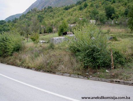
The village of Glavatičevo is in the upper Neretva river valley, on the left bank, about 20 km as the crow flies to the south-east of Konjic. The necropolis with 15 stećci (11 chest-shaped and four gabled) is in the hamlet of Karlušići, about 1 km to the north-west of Glavatičevo, on a site known as Gajine.
The National Monument is located on a site designated as cadastral plot no. 166/1, Land Register entry no. 89, cadastral municipality Glavatičevo, Konjic Municipality, Federation of Bosnia and Herzegovina, Bosnia and Herzegovina.
The plot is in the sole ownership of Didik (Bećir) Huso.
Historical information
The area around the upper Neretva straddles two regions. Since prehistoric times, the roads linking central Bosnia with the Adriatic coast ran along the Neretva valley and its outer margins. With some alterations and adaptations to the route, major roads ran here in antiquity, mediaeval times and the Ottoman period, until the road was laid through the Neretva gorge from Jablanaca to the south in the 1880s. The central Bosnian ore-rich mining area, the fertile soils of the Neretva valley, and the rich mountain pastures, all led to the formation of many settlements throughout history, in line with the conditions and demands of their respective times, on the great bend in the Neretva between the mountain massifs of Bitovnja, Bjelašnica and Visočica to the north, and Prenj and Čvrsnica to the south(1).
Roads have always been an indicator of the way of life in a given area. For Konjic, the natural route linking Hum land, its coastal regions and Dubrovnik with central and northern Bosnia and part of Pannonia – a route where a road was laid in Roman times – was an important feature. Certain documentation concerning major routes in mediaeval times preserves the name Vlaški put (Vlach road), relating for instances to part of the old road from Zaborani to Glavatičevo. These Vlach roads, so called, in Herzegovina are known to have been the routes taken by semi-nomadic herders, most of them of Vlach origin (P. Anđelić, 1982, 90, 91).
In the early mediaeval period, the wider Konjic region consisted of only one political territory, a typical župa (county), the Neretva county. What is now Konjic Municipality also includes part of the Zagorja župa (the area around Bjelimići) and part of the Kom župa (the area around Glavatičevo).
Historical sources often link Kom county with Nevesinje. From the earliest references to them, the actions of the Sanković family were often associated with Nevesinje, and it is telling that Duke Radič Sanković held court at Zaborani, which certainly belonged to the wider Nevesinje area. It may reasonably be deduced, therefore, that in early feudal times, when the župa-based system was working as a whole, Kom county belonged to Nevesinje, just as Viševa belonged to Zagorje. It should be noted that Kom county broke away from Nevesinje at a very early date to become an administrative entity in its own right, known at least nominally as a župa or county. Kom county is known to have belonged to the Sanković feudal holdings throughout the 14th century. From the early 15th century it and the Hum part of the Neretva belonged to the Kosača feudal lands (P. Anđelić, 1982, 111, 112).
To the west, the limits of Neretva county consisted of the Neretva gorge from Prenj to the mouth of the Rama, Mt Bokševica and the gorge of the little river Banja Lučica. To the west of this boundary was Rama county.
On Mt Zec, Neretva county marched with the territory of the mediaeval county of Uskoplje. From Zec, via Pogorelica and Bitovnja, to Mt Ivan, Neretva county marched with the former county of Lepenica; on the slopes of Mt Bjelašnica, Neretva county bordered the county of Vrhbosna. To the east, the boundary between Kom and Neretva counties was formed by the Boračko lake and the river Šištica and Rakitnica gorges. To the south, the limits of Neretva county were formed by the highest peaks in the Prenj mountain chain: Otiš, Zelena glava, Kantar and Cetina. The earliest reference to Neretva county is in the Chronicles of the Doclean priest, written in the mid 12th century, where it is said to have been part of the Podgorje district which, along with Hum land, Trebinje and Zeta, formed a tetrarchy or federation of four districts each of which was a semi-independent country or state. The Podgorje district included not only Neretva county but also the counties Onogošt, Morača, Komarnica, Piva, Gacko, Nevesinje, Viševa, Kom and Rama. By the mid 11th century the county had presumably been incorporated, by political agreement, into the Bosnian state. From then on until ban (governor) Tvrtko came to power in 1353, it enjoyed special status within the Bosnian state (Anđelić, 1982, 108-110).
The earliest written evidence of the ruling domain in the Bosnian Neretva is in a letter from ban Tvrtko of 1356 in curia nostra in Nerethva. The expression curia refers to the court built for the ruler (P. Anđelić, 1983, 103).
Around the mid 14th century, heightened economic and political activities on the part of Bosnia's rulers can be traced in the Neretva župa. In the early 15th century the borders were redrawn between the later “Crown lands” and the feudal lands of the Kosača family. From 1404 to 1463, the Bosnian part of the Neretva župa belonged to the Crown lands and the Hum Neretva and Kom belonged to the feudal lands of the Kosača – later Herzegovina. The border between these two districts was the river Neretva, from the boundary of the Kom župa to that of the Rama župa. The area along the left bank of the Neretva belonged to the Kosačas, and that on the right bank to the Crown lands.
Three feudal clans were active in the Konjic area in addition to the ruling Kotromanić and Kosača dynasties: the Purčić, Sanković and Obrinović families, hereditary members of the assembly of feudal lords, the national assembly of mediaeval Bosnia. They were both overlords of feudal districts and vassals of the king. The Čemerović and Paštrović families were also mediaeval landholders who made their mark in Donje Selo, Lisičići, Bukovica (Gorani) and Glavatičevo (P. Anđelić, 1982, 94).
In the summer of 1463 an auxiliary Ottoman army commanded by Mahmut pasha Anđelović conquered both the Neretva districts and Kom. The area known as Hum Neretva, apart from the Borovac fort, and the western part of the Bosnian Neretva, were liberated in a counter-action between July and September that same year by Herceg (Duke) Stjepan. The region was finally conquered in mid 1465 in a campaign by the Bosnian sandžakbeg Isa-beg Ishaković in the Herceg's lands (Anđelić, 1982, 116).
The mediaeval tombstones of Bosnia and Hum known as stećci became the subject of scholarly interest in not entirely favorable circumstances, hundreds of years after they had become a relic of a historic age. At the turn of the 18th-19th century, the western world began to hear of the unusual art to be found on tombstones in Bosnia and Herzegovina and Dalmatia, initially from the accounts of travelers that were not well documented enough to give rise to any significant interest in the west, particularly since western scholarship was then occupied with the analysis of entirely different works of art; as a result, the realistic, and indeed clumsy scenes on the stećci neither appealed to scholars nor aroused their interest. In Ottoman Bosnia itself, there were no forces capable independently of studying and presenting these treasures of mediaeval art (A. Benac, 1963, XVII, XXIX). In these circumstances, by the mid 19th century – when the process of modern national coalescence was in full swing and the question of whom Bosnia belonged to increasingly took on political and even apocalyptic significance – scholars were inclined to see the art of the stećci as having arisen from Bogomil teachings (A. Benac, 1963, XXIX). Nor was there any lack of efforts to give the stećci a purely Serbian or Croatian national stamp (V. Glušac, 1924, 31-35, 36-37, 50; Südland, 1990, 95, 96). From the mid 20th century, the prevailing scholarly opinion was that the stećci could not be explained by either “bogomilization” or any exclusively national theory, but rather than they should be situated in their own authentic world, the world in which they came into being, evolved and then died out in the late 15th century, after the mediaeval Bosnian state had itself come to an end.
The Bosnian context for the emergence of the stećci was dictated by the growing economic power of 14th century Bosnian feudal society, the opening of mines, and urbanization, along with the desire of individuals to mark their standing and power by the outward image of a tombstone. The large number of graves and burial grounds without stećci attest to the deep class differences of feudal society, which means that, chronologically speaking, the stećci echoed both the advance and the decline of feudalism and the development of towns and the bourgeoisie.
The birthplace of the stećak is Herzegovina (Đ. Basler, 1990, 130), and it was there, too, that the art of the stećak reached its peak. The slab tombstones of župans (lords of the county) of Trebinje, Grd (1151-1178) and Pribilša (1241), which may be regarded as the earliest known stećci, do not suggest a Bogomil origin. Both these župans lived at a time when Hum and Travunija were under Serbian Orthodox rule; nor could the Bosnian Church possibly have been present here (M. Vego, 1963, 196). It was the opening of mines and the urbanization of mediaeval Bosnia that form the context for the emergence of the stećak as a new way of marking graves, which began in Europe in the 12th and 13th centuries with the development of towns and the bourgeoisie. These tombstones are typical of the mediaeval Bosnian state (Š. Bešlagić, 1982, 32).
Stećci form part of an unbroken sepulchral continuity in Bosnia that reaches far back into prehistoric times, and are clearly associated with the older sites of prehistoric settlements and places of worship, agglomerations and burial grounds dating from antiquity, late antique and early mediaeval churches and fortified towns. They are widespread throughout Bosnia and Herzegovina, with the exception of the Posavina (Sava valley area) and the western part of Bosanska Krajina (the frontier region), with a few in western Serbia and Montenegro, Dalmatia and, here and there, in Lika.
Their epitaphs attest to various other names used in tandem to denote the stećci: bilig, kâm (stone), zlamen, kuća (house) and eternal abode. Popular names long in use include mramorje (marbles), mašeti, Greek tombs, old tombs, kaursko groblje (giaours' or infidels' burial grounds), and giants' stones.
The name most commonly used in reference works is stećak, deriving from the fact that they were designed to stand over graves as a monument. The word comes from the present participle of the verb stajati, to stand – stojeći or, as it used to be pronounced, steći.
Perhaps the primary significance of the stećak is its appearance, evolution and metamorphosis from smaller, simpler forms to larger and more complex ones. Though there is as yet no full analysis of the types of stećci, the nine different shapes represented at Radimlja near Stolac may be taken as a starting-point: from the plain slab to the slab with a plinth, the chest-shaped tombstone, the chest-shaped tombstone with plinth and tall chest-shaped tombstone, plain or with plinth, to the sarcophagus (gabled tombstone), sarcophagus with plinth and, finally, cruciform tombstone.
The basic shape of the stećak is a recumbent or erect stone monolith. Erect stone monoliths may be in the form of a stela, obelisk or nišan. Tombstones of this type are found in greater numbers in north-eastern Bosnia (in the Srebrenica and Zvornik area), featuring only singly in other parts of Bosnia and Herzegovina. Most stećci are recumbent monoliths, which take three shapes: slabs, chests and sarcophagi (gabled tombstones). Slabs are the most common, followed by chest-shaped stećci; gabled stećci are the least common. These recumbent tombstones are the primary and principal form of the stećak, and are found throughout the area of their distribution.
The artistic treatment of the stećci is to be seen in their form and decoration. As well as their pure function as lasting grave markers, stećci are designed to arouse in the observe a feeling of beauty, the aesthetic tendency of which is reflected in the forms of the gabled tombstones (sarcophagi) and the so-called tall chests.
The basic artistic quality of the stećci is their decoration, executed using two different techniques – usually in bas relief, though incised lines are not uncommon. The decorative motifs on the stećci possess the marked symbolism characteristic of mediaeval art, and fall into five groups that overlap and complement each other: social and religious symbols, representations of the posthumous round dance, figural scenes and pure ornament. There is also a sixth group of unclassified motifs: those of symbolic function, geometric forms, representations of certain unusual articles, and damaged motifs of which the meaning cannot be deciphered.(2)
Taken as a whole, the ornamentation on the stećci reveals the mindset and sensibility of an entire era, both of the people who were involved in making them and of the deceased whose final resting place is beneath these great tombstones, in honour of whose wishes – as some of the epitaphs reveal – the stećci were carved.(3)
With 3,000 to 4,000 specimens, the Herzegovina municipalities of Nevesinje and Konjic take first place in numbers of stećci, while among the municipalities of Bosnia, Rogatica stands out with 2,628. The number of stećci in a given necropolis is also an important indicator of social movements in mediaeval Bosnia in the 14th and 15th centuries.
Since most necropolises contain fewer than ten stećci, and those with 300 or more, belonging to larger communities, are the exception, small burial grounds may be regarded as family graveyards, indicating that the breakup of the old clan-based society and the emergence of small family communities organizing their own burial grounds as a sign of their “new” identity was already well advanced (P. Anđelić, 1966, 455-495).
The mediaeval conception of death changed in western Europe with the Protestant reformers, who “based their ideas and beliefs solely on the Bible, rather than on a combination of the Bible and `tradition' which had built up over the centuries” (Daniell, 1997, 196-199). Following a brief transitional period marked by the emergence of a hybrid stećak-nišan tombstone, the burial practices embodied in the stećci died out in the decades following the establishment of Ottoman rule in Bosnia and Hum, when gravestones began to differ by confession.
2. Description of the property
According to Š. Bešlagić’s statistics, Konjic municipality – with 3,018 recorded stećci – is one of those with the greatest number of stećci in Bosnia and Herzegovina. In terms of shape, chest-shaped stećci are the most numerous, with gabled and slab-shaped tombstones represented in almost equal numbers. The way in which the stećci are grouped makes it possible to trace and to document on the ground important historical features, processes and relations. The siting of large necropolises is a reliable indication of the centres of former religious and political communities. That of medium-sized necropolises enables one to follow the process of development of clan-based villages, while smaller groups reflect intensive feudalization and social differentiation, when individual clans no longer bury their dead alongside their neighbours, but form their own family necropolises. The stećci in the Konjic region can provide an important contribution to resolving the question of the origin of stećci, both in terms of ethnicity and as regards the origins of their basic form. The Sanković necropolis in Biskup is a striking example of the way in which, throughout the 14th century, stećci were used as tombstones by the most powerful landowning clan in the whole of Hum land, while the Bogopanci – Draživojevići – Sankovići are indubitably of Slav origin and culture, not Vlach. It should be borne in mind that by the 14th century the Vlachs already belonged to lower-class social structures and were certainly not in a position to impose their customs, and in particular the way in which graves were marked, on their overlords. The theory of the Vlach origin of stećci cannot be justified, even though there are several necropolises in the Konjic area, and perhaps the finest at that, which could be attributed to Vlachs.
Decorations on stećci increased in frequency only in the early 14th or late 15th [sic] century). Circumstances such as the geological composition of the rock from which stone was taken to make stećci no doubt influenced the finer shaping of the tombstones. The considerable difference in the quality of workmanship of the stećci in the Neretvica valley, where there was no suitable stone, and that of the karst regions around Glavatičevo and Bjelimići, is striking. It would seem, however, that this was not the only reason for the differences, for the Jablanica area has good material, and yet does not have any particularly evolved forms and decorations. Among the influences from neighboring districts that of southern Herzegovina (old Hum) is particularly noticeable, as can be seen throughout the area to the east of Konjic. In Bradina are low gabled stećci clearly modeled on those of neighboring regions of central Bosnia. The epitaphs on the stećci are of particular value. They are written in Bosnian Cyrillic script, and date from the end of the 14th and the beginning or second half of the 15th century (P. Anđelić, 1975, 223-225).
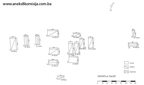
The necropolis with 15 stećci(4) (11 chest-shaped and four gabled) is in the hamlet of Karlušići, about 1 km to the north-west of Glavatičevo, on a site known as Gajine, on a site designated as cadastral plot no. 166/1, cadastral municipality Glavatičevo. The stećci are of good workmanship, but some are chipped or partly buried. Following a survey of the necropolis and locating the stećci, it was found that two are missing. The stećci lie north-west/south-east, and south-west/north-east. Seven of them are decorated (three chest-shaped, nos. 1, 4 and 7, and four gabled, nos. 2, 3, 6 and 14). The decorative motifs are rope twist, a frieze of twining vines with trefoils, a twisted garland, arcades, a double spiral, an elder's staff, and parallel ribbing.
The name of the site, Gajine, is indicative in itself. According to Vl. Mažuranić, gaj means “lucus [a sacred grove], a cultivated grove, protected from harm, and grown by human hand.” Two aspects of the term gaj are significant:
a) it indicates a wooded site,
b) the site is subject to specific conditions of cultivation and use.
P. Anđelić identified more than fifty toponyms based on the term gaj in the Neretva area (Gaj, Gajevi, Gajine, Gajić etc.). There is no direct evidence of such groves in mediaeval Bosnia and Hum, but sites with such names are owned exclusively by groups of a few or several private individuals. The land is second-grade in quality, and consists of meadowland, pastures and arable land. In some cases, there are settlements in such groves, ranging in size from one to ten hectares, usually with precisely defined boundaries. The toponomastics thus preserves the memory of a kind of collective property ownership. The erosion of this collective ownership of groves was probably complete even before the coming of the Ottomans. This would explain why none of the groves recorded by P. Anđelić was in collective ownership: on the contrary, all were in private hands (P. Anđelić, 1975, 270, 271).
Another feature of this necropolis, in addition to its elaborately decorated stećci, is that one bears on its north-west side ''symbols suggesting an unknown script,'' while the south-west end is decorated with a T-shaped ''djed's'' (elder's) staff, and the top with relief parallel ribbing (P. Anđelić, 1975, 265).
Condition of the stećci
Stećak no. 1 – chest with decoration, covered with lichens and moss and overgrown with grass, lying north-west – south-east, measuring 216 x 120 x 59 cm. The sides are decorated with rope twist and a frieze of twining vines with trefoils.
Stećak no. 2 – gabled with decoration, covered with lichens and moss and overgrown with grass, lying north-west – south-east, measuring 181 x 70 x 58 cm. The south-east end is decorated with a double (spectacle-like) spiral the top of which is shaped into a circle.
Stećak no. 3 – gabled with decoration, covered with lichens and moss and overgrown with grass, lying north-west – south-east, measuring 165 x 62 x 70 cm. The south-east end is decorated with a double (spectacle-like) spiral the top of which is shaped into a circle, with above it a transverse rope twist.
Stećak no. 4 – chest with decoration, covered with lichens and moss and overgrown with grass, lying south-west – north-east, measuring 218 x 100 x 101 cm. All four sides bear the identical decorative motifs – round-arched arcades touching a horizontal line separating them from the top of the stećak, with the edges of the niches simply marked by a double line.
Stećak no. 5 – chest, undecorated, covered with lichens and moss and overgrown with grass, lying south-west – north-east, measuring 183 x 100 x 60 cm.
Stećak no. 6 – gabled with decoration, covered with lichens and moss and overgrown with grass, lying south-west – north-east, measuring 190 x 69 x 122 cm. The stećak is decorated on all four sides. The two ends bear different decorations. The south-west end is decorated with a stylized tree and two pairs of spiral bands above which is a transverse rope twist; two vertical ''staffs'' on either side of the tree run the length of the stećak. The north-east end merely has two vertical staffs with a relief line above. The sides are decorated in the same way with round-arched arcades. Between the top of the roof pane and the arcades is a band of vines and trefoils. The motifs are in a combination of relief and reverse relief.
Stećak no. 7 – chest with decoration, covered with lichens and moss and overgrown with grass, partly buried, lying south-west – north-east, measuring 140 cm long x 40 cm high. The south-west end is decorated with a T-shaped staff, which P. Anđelić believes to be an elder's staff (P. Anđelić, 1975, 204). The north-west side is marked with mysterious symbols that reminded Anđelić of some unknown script (P. Anđelić, 1974, 265), and the top is decorated with relief parallel ribbing.
Stećak no. 8 – chest, undecorated, covered with lichens and moss and overgrown with grass and low-growing plants, lying north-west – south-east, measuring 187 x 80 x 72 cm
Stećak no. 9 – slab, undecorated, covered with lichens and moss and overgrown with grass and low-growing plants, lying south-west – north-east, measuring 180 x 105 x 25 cm
Stećak no. 10 – chest, undecorated, covered with lichens and moss and overgrown with grass and low-growing plants, sunken to the south-east, lying south-west – north-east, measuring 130 x 55 x 53 cm
Stećak no. 11 – chest, undecorated, covered with lichens and moss and overgrown with grass and low-growing plants, lying north-west – south-east, measuring 180 x 82 x 42 cm
Stećak no. 12 – chest, undecorated, covered with lichens and moss and overgrown with grass and low-growing plants, lying north-west – south-east, measuring 164 x 77 x 56 cm
Stećak no. 13 – chest, undecorated, partly buried, covered with lichens and moss and overgrown with grass and low-growing plants, lying north-west – south-east, measuring 183 x 89 x 28 cm
Stećak no. 14 – gabled with decoration, covered with lichens and moss and overgrown with grass and low-growing plants, sunken to the south-east, lying north-west – south-east, measuring 188 x 55 x 100 cm. The sides and ends are decorated with a frieze of twining vines with trefoils.
Stećak no. 15 –chest, undecorated, partly buried, covered with lichens and moss and overgrown with grass and low-growing plants, lying north-west – south-east, measuring 126 x 40 x 30 cm.
3. Legal status to date
The Regional Plan for BiH to 2000 lists 69 sites of necropolises with stećci (3,018 tombstones) in Konjic Municipality, without precise identification, treating them as Category III monuments.
4. Research and conservation and restoration works
Research works, in the form of recording and gathering information on the stećci, were carried out by Pavao Anđelić and published in 1975.
No conservation or restoration works have been carried out.
5. Current condition of the property
The findings of an on-site inspection conducted on 23 September 2008 are as follows:
- the stećci are at risk of rapid deterioration from lack of maintenance,
- some of the stećci are chipped, damaged, overturned, or partly or wholly buried,
- the site with the stećci is on a plot that is not fenced off, which enables the local people to use the plot as arable land,
- the stećci are covered to a greater or lesser extent with plant organisms (lichens and moss),
- most of the upper surfaces of the chests and slabs are more or less damaged (cracks, splits, shallow cracks),
- of the four gabled stećci recorded, two are partly buried (nos. 2 and 3), no. 6 has damage to the north-east side, and no. 14 is leaning to the south-east.
6. Specific risks
- disintegration of the necropolis as a result of long-term neglect,
- adverse weather conditions,
- self-sown vegetation.
III – CONCLUSION
Applying the Criteria for the adoption of a decision on proclaiming an item of property a national monument (Official Gazette of BiH nos. 33/02 and 15/03), the Commission has enacted the Decision cited above.
The Decision was based on the following criteria:
A. Time frame
B. Historical value
C. Artistic and aesthetic value
C.i. quality of workmanship
C.iii. proportions
C.v. value of details
D. Clarity
D.i. material evidence of a lesser known historical era
E. Symbolic value
E.v. significance for the identity of a group of people
G. Authenticity
G.i. form and design
G.ii. material and content
G.iv. traditions and techniques
The following documents form an integral part of this Decision:
- Copy of cadastral plan,
- Copy of land register entry,
- Photodocumentation, photographs taken on site.
Bibliography
During the procedure to designate the monument as a national monument of Bosnia and Herzegovina the following works were consulted:
1924. Glušac, Vaso, “Srednjovekovna ‘bosanska crkva’", in: Prilozi za književnost, jezik, istoriju i folklor, IV (The Mediaeval “Bosnian Church”, in Contributions to Literature, Language, History and Folklore, IV, Belgrade, 1924.
1963. Benac, Alojz, Stećci, Prosveta, Belgrade, 1963.
1963. Vego, Marko, “Patarenstvo u Hercegovini u svjetlu arheoloških spomenika”, Jnl of the National Museum, n.s. (A), XVIII, Sarajevo, 1963.
1966. Anđelić, Pavao, “Doba srednjovjekovne bosanske države” (The Age of the Mediaeval Bosnian State), in: Kulturna istorija Bosne i Hercegovine od najstarijih vremena do početka turske vladavine (Cultural History of Bosnia and Herzegovina from Earliest Times to the Start of Turkish Rule), Sarajevo, 1966.
1975. Anđelić, Dr. Pavao, Historijski spomenici Konjica i okoline (Historic Monuments of Konjic and its Environs) I, Konjic Municipal Council, 1975.
1980. Various authors, Regional Plan for Bosnia and Herzegovina; Stage B - valorization of natural, cultural and historical monuments, Institute for architecture, town planning and regional planning of the Faculty of Architecture in Sarajevo, Sarajevo, 1980, 51.
1982. Anđelić, Pavao, “Teritorijalno politička organizacija župe Neretve i njezino mjesto u širim političkim okvirima” (Territorial and political organization of the Neretva County and its place in the broader political context) In: Studije o teritorijalnopolitičkoj organizaciji srednjovjekovne Bosne (Studies on the territorial and political organization of mediaeval Bosnia), Sarajevo, 1982.
1982. Bešlagić, Šefik, Stećci. Kultura i umjetnost (Stećak tombstones – culture and art), Veselin Masleša, Sarajevo, 1982.
1990. Basler, Đuro, Kršćanska arheologija, II. izdanje, Crkva na kamenu (Christian Archaeology, 2nd ed, Churches in Stone), Mostar, 1990.
1990. Südland, L. V. (Ivo Pilar), Južnoslavensko pitanje. Prikaz cjelokupnog pitanja, Varaždin (The Yugoslav Question. Full account of the issue, Varaždin). Title of original: L. v. SÜDLAND, Die Südslawische Frage und der Weltkrieg. Übersichtliche Darstellung des Gesamt-Problems, Wien, 1990.
1997. Daniell, Christopher, Death and Burial in Medieval England, 1066-1550, Routledge, London and New York, 1997.
(1) The historical information section has been taken from the Decision designating the Archaeological Monuments in the Park at Varda below the Social Centre in Konjic as a National Monument
(2) The world of Bosnia's and Hum's stećci abounds in symbolism, full of crosses, crescent moons, solar discs, swastikas and stars, scenes of the round dance, tournaments, cavalry processions, military weapons, shields and arcades, vines and bunches of grapes, stylized fleur de lis and rosettes, deer and wild boar, coats of arms, swords and spears, portraits of the deceased with a disproportionately large raised hand, books, roofs and representations of houses.
(3) In line with the specific political, economic and cultural situation of various regions, the art of the stećak led to the formation of distinctive local styles. The leading role is that of the stonemasons' yard in Herzegovina, based in the Stolac region, in Trebinje and Bileća, and in Gacko and Nevesinje. A fourth stonemasons' yard was active in the wider Konjic area, and a fifth in the Lištica region. The principal stonemasons' centres in western Bosnia covered the area between Kupres and Duvno, and those of central Bosnia provided for the area around Travnik. In eastern Bosnia, the work of four stonemasons' yards can be identified: one between Kladanj, Olovo and Ilijaš, another around Zvornik, a third in Ludmer and a fourth around Rogatica. There were also centres of scribes, with the Herzegovina school – probably with several centres or workshops – again in first place. A significant centre of epigraphic literacy was to be found in the Stolac area, with Semorad as its most prominent figure (Š. Bešlagić, 1982, 479-482).
(4) P. Anđelić recorded 17 stećci (1 slab, 12 chests and 4 gabled) on the site (P. Anđelić, 1975, 204), and Š. Bešlagić recordced 15 (11 chests and 4 gabled) (Š. Bešlagić, 1971, 332).
|