Status of monument -> National monument
Published in the “Official Gazette of BiH” no. 53/08.
Pursuant to Article V para. 4 Annex 8 of the General Framework Agreement for Peace in Bosnia and Herzegovina and Article 39 para. 1 of the Rules of Procedure of the Commission to Preserve National Monuments, at a session held from 28 March to 1 April 2008 the Commission adopted a
D E C I S I O N
I.
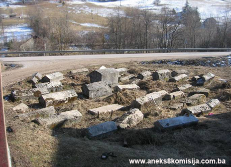
The historic monument known as "Mramorje", a group of 39 stećak tombstones in Donji Čevljanovići, municipality Ilijaš, is hereby designated as a National Monument of Bosnia and Herzegovina (hereinafter: the National Monument).
The National Monument consists of a group of 39 stećak tombstones, 32 gabled and seven chest-shaped.
The National Monument is located on a site designated as cadastral plot no. 427/1, title deed no. 14, Land Register entry no. 81, cadastral municipality Hadžići – Crna Rijeka, Municipality Ilijaš, Federation of Bosnia and Herzegovina, Bosnia and Herzegovina.
The provisions relating to protection measures set forth by the Law on the Implementation of the Decisions of the Commission to Preserve National Monuments, established pursuant to Annex 8 of the General Framework Agreement for Peace in Bosnia and Herzegovina (Official Gazette of the Federation of BiH nos. 2/02, 27/02, 6/04 and 51/07) shall apply to the National Monument.
II.
The Government of the Federation of Bosnia and Herzegovina (hereinafter: the Government of the Federation) shall be responsible for providing the legal, scientific, technical, administrative and financial measures necessary to protect, conserve, and display the National Monument.
The Commission to Preserve National Monuments (hereinafter: the Commission) shall determine the technical requirements and secure the funds for preparing and erecting signboards with basic details of the monument and the Decision to proclaim the property a National Monument.
III.
To ensure the on-going protection of the National Monument on the site defined in Clause 1 para. 3 of this Decision, the following protection measures are hereby stipulated:
- all works are prohibited other than conservation and restoration works, including those designed to display the monument, with the approval of the Federal Ministry responsible for regional planning (hereinafter: the relevant ministry) and under the expert supervision of the heritage protection authority of the Federation of Bosnia and Herzegovina (hereinafter: the heritage protection authority),
- the site shall be open and accessible to the public, and may be used for educational and cultural purposes,
- works on the infrastructure are prohibited unless with the approval of the relevant ministry and subject to the expert opinion of the heritage protection authority,
- all building and works of any kind that could have the effect of altering the site or the area are prohibited, as is the erection of temporary or permanent structures not designed solely to protect and present the National Monument,
- the dumping of all kinds of waste is prohibited,
- erect a suitable barrier to prevent protect the tombstones.
The Government of the Federation shall be responsible in particular for ensuring that a programme is drawn up for the systematic investigation and conservation of the stećak tombstones, to include a geodetic survey of the current condition of the property, and for drawing up and implementing a programme for the presentation of the National Monument
IV.
All executive and area development planning acts not in accordance with the provisions of this Decision are hereby revoked.
V.
Everyone, and in particular the competent authorities of the Federation of Bosnia and Herzegovina, the Canton, and urban and municipal authorities, shall refrain from any action that might damage the National Monument or jeopardize the preservation thereof.
VI.
The Government of the Federation, the Federal Ministry responsible for regional planning, the Federation heritage protection authority, and the Municipal Authorities in charge of urban planning and land registry affairs, shall be notified of this Decision in order to carry out the measures stipulated in Articles II to V of this Decision, and the Authorized Municipal Court shall be notified for the purposes of registration in the Land Register.
VII.
The elucidation and accompanying documentation form an integral part of this Decision, which may be viewed by interested parties on the premises or by accessing the website of the Commission (http://www.aneks8komisija.com.ba)
VIII.
Pursuant to Art. V para 4 Annex 8 of the General Framework Agreement for Peace in Bosnia and Herzegovina, decisions of the Commission are final.
IX
This Decision shall enter into force on the date of its adoption and shall be published in the Official Gazette of BiH.
This Decision has been adopted by the following members of the Commission: Zeynep Ahunbay, Amra Hadžimuhamedović, Dubravko Lovrenović, Ljiljana Ševo and Tina Wik.
No: 02-2-23/2008-5
29 March 2008
Sarajevo
Chair of the Commission
Amra Hadžimuhamedović
E l u c i d a t i o n
I – INTRODUCTION
Pursuant to Article 2, paragraph 1 of the Law on the Implementation of the Decisions of the Commission to Preserve National Monuments, established pursuant to Annex 8 of the General Framework Agreement for Peace in Bosnia and Herzegovina, a “National Monument” is an item of public property proclaimed by the Commission to Preserve National Monuments to be a National Monument pursuant to Articles V and VI of Annex 8 of the General Framework Agreement for Peace in Bosnia and Herzegovina and property entered on the Provisional List of National Monuments of Bosnia and Herzegovina (Official Gazette of BiH no. 33/02) until the Commission reaches a final decision on its status, as to which there is no time limit and regardless of whether a petition for the property in question has been submitted or not.
On 25 December 2002 Ilijaš Municipality submitted a petition/proposal to designate the historic site of the necropolis with stećak tombstones in Čevljanovići as a national monument of Bosnia and Herzegovina.
Pursuant to the provisions of the law, the Commission proceeded to carry out the procedure for reaching a final decision to designate the Property as a National Monument, pursuant to Article V para. 4 of Annex 8 and Article 35 of the Rules of Procedure of the Commission to Preserve National Monuments.
II – PROCEDURE PRIOR TO DECISION
In the procedure preceding the adoption of a final decision to proclaim the property a national monument, the following documentation was inspected:
- Documentation on the location and the current owner and user of the property (copy of cadastral plan and Land Register entry),
- The current condition and use of the property, including a description and photographs, data of war damage, data on restoration or other works on the property, etc.
- Historical, architectural and other documentary material on the property, as set out in the bibliography forming part of this Decision.
The findings based on the review of the above documentation and the condition of the site are as follows:
1. Details of the property
Location
The village of Donji Čevljanovići is about 20 km as the crow flies to the north-east of Ilijaš, on the M-18 Sarajevo to Tuzla road. The stećak tombstones are to the north of the village, on the left-hand side of the road. The site has 39 tombstones, 32 gabled and seven chest-shaped.
The tombstones are of good workmanship, but are damaged. They stand in rows running east-west, with the tombstones lying north-south.
The National Monument is located on a site designated as cadastral plot no. 427/1, title deed no. 14, Land Register entry no. 81, cadastral municipality Hadžići – Crna Rijeka, Municipality Ilijaš, Federation of Bosnia and Herzegovina, Bosnia and Herzegovina.
Historical information
The earliest traces of life in the area of present-day Ilijaš Municipality are associated with the Palaeolithic, as evidenced by the complex of the Bijambara caves on the Crna Rijeka plateau. This is in an area that formerly belonged administratively to the village of Nišići in Srednje Municipality, and is still known to the local people as the Krivajevička cave. The cave complex was first investigated in September 1967 by Mirko Malez, who determined on the basis of the artifacts he found that it belonged to the Epigravettian culture, i.e. the most recent period of the Upper Palaeolithic. These were also the first finds of this Palaeolithic culture in accurately fixed deposits in Bosnia. In addition, pottery shards from the late Bronze Age and the Hallstadt periods were found in the complex (M. Malez, 1968, 159-178).
Further evidence for the presence of prehistoric sites in this area is to be found in the places known locally as Gradina, Gradac, Grad etc. (trans.: all names suggesting a hillfort or fortifications of some kind) (M. Kadrić, 1995, 23).
During the Illyrian period, from the 9th century BCE to the coming of the Romans in 9 CE, the area was inhabited by the Daesitiates tribe, with its stronghold in Breza (Hedum castellum Daeisitiatum) (I. Bojanovski, 1984, 49). An inscription from Breza dating from 2 BCE, princeps Daesitiatum, indicating that the rank of prince existed in this tribe, suggests that it was well organized (B. Čović, 1976, 198).
In Roman times, too, the area around present-day Breza in the river Stavnja valley remained one of inner Bosnia's major political centers. There are also traces of settlements of this period around the confluence of the river Misoča and the Bosna, in present-day Ilijaš (P. Anđelić, 1971, 343).
Fortifications dating from the Roman or mediaeval period include Gradina – hillforts – in Balibegovići and Crna Rijeka. The ancient settlement of Kamenica lies on the broad Crna Rijeka plateau between Olovo and Vareš, Srednje and Čevljanovići. There are rich deposits of iron, lead, manganese and mercury ores in this area. It was natural, therefore, for the settlement to develop initially as a marketplace, and later as a customs post where duties were levied on ores taken to Dubrovnik (in Dalmatia). Customs duties were charged there as long ago as 1384 – Portorium in Kamenica. King Tvrtko I farmed out the customs to Dubrovnik traders Dragoje Gučetić and his band of men. A charter of King Dabiša of 6 March 1392 records that people from Dubrovnik had held the customs post eight years previously. There is reference to a mine shaft near Kamenica in 1387 (M. Kadrić, 1995, 23).
Later, in addition to lead mining, the extraction of iron and manganese ores began in this area. The extraction of the ore, the levying of customs duties and the export or the ore led to the formation in the Kamenica area of Gradina, a market and customs post, whence the ore was transported by horse caravans via Sutjeska, Visoko, Lepenica, Bradina, Konjic and Gabela to Dubrovnik.
Lead ore was in the hands of the bans (governors) and then of the kings of Bosnia. By the end of the 15th century, it belonged to the feudal landowning Radenović family, though some documents from 1398 note that the lead duties in Kamenica were royal. In the 15th century the customs duties on lead ore were shared by the Radenović-Pavlović and Hranić families; by 1418 they were held by Duke Sandalj Hranić (M. Vego, 1957, 84).
The fortified town of Dubrovnik is referred to as the residence of an overlord in this part of the country, with the earliest written reference dating from 11 June 1404. The actual name of the fort is Dabrovnik (Ibidem, 37).
In early mediaeval times, the area of the river Bosna valley between the Sarajevo and Visoko plains was a župa (county) known as Vidogošća or Vogošća. Župas were the basic administrative and political entities in the territorial organization of all south Slav lands in early mediaeval times.
The earliest reference to Vidogošća (Vogošća) is in a deed of gift of the Hungaro-Croatian king Bela IV of 1244, confirming the old holdings of the Bosnian bishopric. Part of the bishopric's territory still preserves the old name. The county-based organization was certainly in existence by the first half of the 13th century, and probably even earlier. The political centre of the county was probably in the river Stavnja valley.
In the 14th century the political centre shifted to the Misoča river valley, to the fortified town of Dubrovnik(1). The old župa became a comitatus, but apparently with its territory unaltered. This is suggested by the better-known situation in the Ottoman period. In 1469 and 1485 there are already references to the fortified town and a nahija (smaller administrative unit) of that name. From then on until the early 18th century there are occasional reference to the town of Dubrovnik and its nahija, and also to its dizdars (fortress commanders) or spahis whose holdings were in the nahija (P. Anđelić, 1971, 337-346).
2. Description of the property
According to the studies conducted by Šefik Bešlagić from 1964 to 1966 in Ilijaš Municipality, 32 sites of mediaeval necropolises were recorded in twenty villages, with a total of 518 stećak tombstones, putting this municipality in first place in Central Bosnia in the number of tombstones. Most of the tombstones are chest-shaped (240) or gabled (236), with the remainder consisting of slabs (41) and one vertical stećak (Š. Bešlagić, 1967, 87).(2)
In 1967 Šefik Bešlagić found two necropolises in Donji Čevljanovići: the first in Donji Čevljanovići itself and the other at Drina, on the left bank of the river Ljubina, where there were six stećak tombstones, all gabled and of excellent workmanship, but without decoration.(3)
The stećak tombstones at Mramorje in Donji Čevljanovići
The site has 39 tombstones, 32 gabled and seven chest-shaped. The necropolis is on a plot with an area of about 240 sq.m.
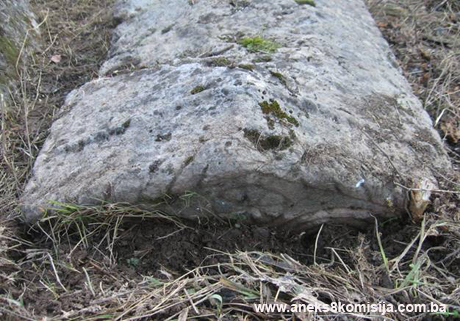
The tombstones are of good workmanship, but are overgrown with moss; some are overturned, and some are damaged. They stand in rows running east-west, with the tombstones themselves lying north-south. Decorative ornament can be seen on five of them (four gabled and one chest-shaped).
The graves on which the tombstones stood were destroyed in 1959 when the main road was built. All but one of the gabled tombstones have plinths, and most have been shaped to be rather narrower at the base.
To conduct a systematic study of the necropolis, determining the exact number of stećak tombstones and taking their precise measurements, classifying and cataloguing them, the site needed to be cleared first. To this end the vegetation and weeds have been physically removed and the stećak tombstones have been cleaned.
Condition of the stećak tombstones
Stećak no. 1 – gabled, covered with moss, damaged, missing the north end. The stećak measures 230 x 80 x 65 cm, the plinth is 246 cm long with a visible height of 12 cm, ends 18 cm deep and sides 15 cm deep.
Stećak no. 2 – gabled, of good workmanship and well preserved. The stećak measures 97 x 44 x 35 cm, the plinth is 111 cm long with ends 13 cm deep and sides 11 cm deep.
Stećak no. 3 – gabled, covered with moss, damaged on the ridge and south side of the plinth. The stećak measures 166 x 74 x 64 cm, the length of the plinth could not be accurately measured since part of it is missing, and the ends are 18 cm deep and sides 19 cm deep.
Stećak no. 4 – overturned, damaged and not in its original position; probably gabled without plinth, since it is rather narrower at the base. It measures 140 x 56 x 44 cm.
Stećak no. 5 – gabled, covered with moss, damaged on the gable and north side of the plinth. The stećak measures 180 x 68 x 40 cm; the plinth is 12 cm deep at the south end and 12 cm deep on the east side.
Stećak no. 6 – gabled, covered with moss, of good workmanship, but broken along its entire length and missing its west side. The stećak measures 170 x 80 x 84 cm, the south end of the plinth 12 cm, the north end of the plinth 32 cm, the east side of the plinth 15 cm.
Stećak no. 7 – gabled, covered with moss, damaged on the north side of the ridge and missing part of its plinth, missing part of the east roof pane at the south end. The stećak measures 174 x 62 x 60 cm, and the plinth is 17 cm high, with the south end 8 cm deep and the east side 8 cm deep.
Stećak no. 8 – gabled, the northern part sunken and damaged on the ridge, and part of the east roof pane damaged at the south end. The stećak measures 94 x 48 x 30 cm; the plinth is 12 cm high, with the south end 6 cm deep and the west side 10 cm deep.
Stećak no. 9 – gabled, of good workmanship and finish, damaged south end. The stećak measures 175 x 60 x 55 cm; the plinth is 15 cm high, with the south end 19 cm deep, the north end 16 cm deep, and the east side 14 cm deep.
Stećak no. 10 – chest-shaped, obvious weathering damage to the surface, and damage to the southern part of the stećak, which measures 155 x 66 x 25 cm.
Stećak no. 11 – gabled, with decoration, damaged eastern part where the roof pane meets the sides of the stećak and damage to the eastern corner of the north end of the plinth. The ends have a double spiral combined with a cross and fleur-de-lis; one of the gables also has a triangular frame. There is a small rosette above this, with another on either side. A rope-twist runs along the ridge and horizontal edges of the roof. Two such rope-twists also cross the roof panes. The stećak measures 184 x 73 x 62 cm; the plinth is 17 cm high, with the south end 15 cm deep, the north end 16 cm deep, and the east side 15 cm deep.
Stećak no. 12 – gabled, damage to the ridge at the south end, sunken at the north end and at risk from the village road. The stećak measures 165 x 56 x 47 cm; the plinth is 16 cm deep at the south end and 5 cm deep on the west side.
Stećak no. 13 – chest-shaped, covered with moss, part of the south end missing. The stećak measures 30 x 80 x 33 cm.
Stećak no. 14 – gabled, of good workmanship, sunken, covered with moss, damage to the middle of the ridge, damage to the edges of the roof pane at the north end. The stećak measures 165 x60 x 35 cm; the plinth is 13 cm deep at the south end and 12 cm deep on the west side.
Stećak no. 15 – chest-shaped, of coarse workmanship, covered with moss, the north end sunken. The stećak measures 170 x 75 x 36 cm.
Stećak no. 16 – gabled, of good workmanship and finish, plinth sunken. The stećak measures 90 x 40 x 27 cm.
Stećak no. 17 – chest-shaped, of coarse workmanship, covered with moss. The stećak measures 155 x 70 x 40 cm.
Stećak no. 18 – gabled, with decorative ornaments, covered with moss, plinth sunken, the stećak damaged at the south end and missing part of the ridge, and with a diagonal crack across the middle of the gable end and roof pane. The stećak measures 145 x 48 x 39 cm. On the north end is a cross with the three upper arms ending in circles and the bottom arm widening. A rope-twist frieze runs around the sides and onto the end, where it follows the sloping edges of the roof. No decoration on the south end.
Stećak no. 19 – chest-shaped, of coarse workmanship, covered with moss, the north end sunken into the ground. The stećak measures 183 x 70 cm, with a maximum visible height of 32 cm.
Stećak no. 20 – gabled, covered with moss, sunken along its entire length (it is recorded as having a plinth); damaged ridge and plinth at the north end, where part of the west side of the stećak is missing, and damage to the ridge of the stećak at the south end. The stećak measures 133 x 58 cm, with a maximum visible height of 37 cm.
Stećak no. 21 – gabled, plinth sunken, damage to the ends and the western part of the side edges of the roof pane. The stećak measures 159 x 60 x 35 cm.
Stećak no. 22 – gabled, of good workmanship, covered with moss. The stećak measures 178 x 68 x46 cm; the visible height of the plinth is 8 cm, with the south end 18 cm deep, the east side 14 cm deep, the north end 14 cm deep and the west side 16 cm deep.
Stećak no. 23 – gabled, of good workmanship and finish. It stands out on account of its grandiosity and beauty, though covered with moss and lichens and damaged on the eastern edge of the south end of the stećak and the western part of the plinth, which also has damage to part of the north end. The stećak measures 202 x 115 x 112 cm; the plinth is 25 cm high, with the south end 20 cm deep and the west side 20 cm deep.
Stećak no. 24 – gabled, covered with moss, plinth sunken, damage to the edges of the south end of the stećak, cracks on the western part of the side and the roof pane, damage to the eastern part of the north end where the sides meet the roof pane and to the sides of the western roof pane. The stećak measures 48 x 63 cm, with a visible height of 52 cm.
Stećak no. 25 – chest-shaped, of poor workmanship, sunken, visible weathering damage to the surface of the stećak, which also has damage to the northern part; weeds to east and west. The stećak measure 140 x 55 cm with a visible height of 25 cm.
Stećak no. 26 – gabled, covered with moss, the northern part sunken, damage to the south end. The stećak measures 168 x 70 x 70 cm; the plinth is 10 cm high, with the south end 10 cm deep and the east side 15 cm deep.
Stećak no. 27 – gabled, covered with moss and lichens, of good workmanship and finish, damage to the west side at the southern end (part of the stećak missing). The stećak measures 192 x 83 x 77 cm; the visible height of the plinth is 8 cm, and the south end is 20 cm deep, the north end 22 cm deep, and the east side 22 cm deep.
Stećak no. 28 – gabled, in good condition, of good workmanship, with the east side buried under piled-up earth. The stećak measures 180 x 66 x 48 cm; the visible height of the plinth is 12 cm, with the south end 13 cm deep, the north end 13 cm deep, and the west side 13 cm deep.
Stećak no. 29 – gabled, of good workmanship, the northern part of the plinth sunken and the southern part of the plinth damaged. The stećak measures 173 x 68 x42 cm; the south end of the plinth is 17 cm deep, the east side 17 cm deep and the west side 17 cm deep.
Stećak no. 30 – gabled, the northern part sunken into the ground and the western part damaged, the southern part damaged at the end, damage also to the east side with the stećak cracked diagonally more than half way through. The stećak measures 150 x 70 x 52 cm; the plinth is 17 cm deep at the south end and 14 cm deep on the east side.
Stećak no. 31 – chest-shaped, with decorative ornaments, of fine workmanship, sunken. The stećak measures 174 x 72 cm, with a visible height of 15 cm. The horizontal surface is incised with a rectangular border of parallel diagonal lines.
Stećak no. 32 – gabled, of good workmanship, northern part of the plinth sunken, covered with moss and lichens. The stećak measures 199x 7 x 64 cm; the visible height of the plinth is 8 cm, with the south end 17 cm deep and the west side 16 cm deep.
Stećak no. 33 – gabled, of good workmanship, covered with moss, sunken into the ground to the north and east, damage to the ridge at the north end. The stećak measures 200 x 66 x 56 cm; the plinth is 18 cm deep at the south end and 18 cm deep on the west side.
Stećak no. 34 – gabled, of good workmanship and finish, covered with moss, plinth sunken, cracked more than half way through. The stećak measures 173 x 84 x 59 cm.
Stećak no. 35 – gabled, of good workmanship and finish, covered with moss, sunken and leaning to the west, cracked more than half way through, covered with piled up earth on the east side, and in a position that puts it at risk from the village road, damage to the northern part of the ridge. The stećak measures 160 x 64 x 42 cm.
Stećak no. 36 – gabled, with decorative ornaments, plinth sunken, visible cracks to the east side of the stećak and to the northern part of the roof pane, damage to the roof panes at the southern end. The stećak measures 135 x 56 cm, with a visible height of 38 cm. The south end has two symmetrical spirals with the ends turned upwards and three small rosettes above. The north end has two symmetrical spirals below and another two small spiral additions to the right and left; above are three pairs of ribs meeting and running parallel to the roof edges. The sides have three pairs of symmetrical spirals with two rosettes between them. The middle pair of spirals are turned upwards, with two diagonal lines at the ends.
Stećak no. 37 – gabled, with decorative ornaments, of good workmanship, sunken to plinth height, cracked at the north end where there is also damage to the roof panes, north end sunken into the ground. The stećak measures 200 x 78 x 50 cm. A rope twist runs along the base of the roof, over the ridge and across the roof panes, parallel with the sloping edges. The ends have a motif of two symmetrically-placed spirals with handles and a rosette above (though the north end is buried in soil, it has been checked that the decoration is the same as on the south end). All this is surrounded by a rope twist that also runs along the roof and vertical edges. The motif on the west side also has a cluster of grapes between the handles of the spirals. The west side bears a banner motif and an S-spiral at each end. The other side has an arm to the shoulder, bent at the elbow, and also has two S-spirals.
Stećak no. 38 – gabled, overturned to the east, covered with moss and vegetation, sunken at the north end. The stećak measures 44 cm high, the plinth is 184 cm long and 19 cm high; the other measurements could not be taken because of the position of the stećak.
Stećak no. 39 – gabled, sunken at the north end, overgrown with vegetation and covered with weeds, damage to the south end. The stećak measures 138 x 60 x 40 cm.
3. Legal status to date
During the procedure prior to the adoption of a final decision on designation, the records on the protection of the property were inspected, and the findings are as follows:
The Regional Plan for BiH to 2000 lists 22 sites of necropolises with stećak tombstones (505 in all) as Category III monuments, without identifying them more accurately (various authors, 1980, 50).
A letter from the Institute for the Protection of Monuments of the Federal Ministry of Culture and Sport dated 21 January 2008 States that there are two necropolises with stećak tombstones in Donji Čevljanovići: Drina (with six stećak tombstones) and Mramorje (relocated). These properties were not on the Register of Cultural Monuments of the Socialist Republic of Bosnia and Herzegovina.
4. Research and conservation and restoration works
Research works, consisting of recording and visiting sites and describing their existing condition in the Ilijaš area, were conducted by Šefik Bešlagić in 1967. His findings were as follows:
„Village on the main Sarajevo-Olovo road, about 20 km as the crow flies north-east of Ilijaš. There are two necropolises of stećak tombstones in the village: to the north of the village, right beside the main road, is a necropolis with 41 stećak tombstones, 32 gabled and nine chest-shaped. The necropolis is not in its original location. Part of the main road was planned to run right through the necropolis, and the entire necropolis was therefore moved about 30 m to the west-south-west in 1959. Care was taken to disrupt the arrangement of the tombstones as little as possible. The graves beneath the stećak tombstones were destroyed by bulldozers without having first been excavated. There are thus no graves beneath the stećak tombstones in the necropolis today“ (S. Bešlagić, 1967, 18).
No conservation or restoration works have been carried out.
5. Current condition of the property
The findings of an on-site visit conducted on 13 February 2008 are as follows:
- almost all the stećak tombstones are overgrown with low-growing grass, brambles, weeds and moss, as a result of lack of maintenance; some cannot be seen at all, being completely overgrown with grass, so that only their outlines can be made out,
- in order to conduct a systematic study of the stećak tombstones, the necropolis was temporarily cleared, entailing the physical removal of vegetation and weeds,
- some of the stećak tombstones are chipped, damaged, overturned or partly sunken into the ground, and are at risk in their new location from the village road,
- there are plant organisms on most of the stećak tombstones, mainly lichens and mosses, which are damaging the structure of the stone,
- the site contains 39 stećak tombstones, 32 gabled and seven chest-shaped,
- the stećak tombstones were moved from their original positions when the main road was built in 1959; when S. Bešlagić conducted his study of stećak tombstones (1964-1966). He stated that they lie west-east in north-south rows, but they now lie north-south,
- there are no graves beneath the stećak tombstones in the necropolis,
- the majority of the stećak tombstones are of good workmanship and well preserved,
- the area of the necropolis becomes still more overgrown with grass, weeds and brambles as plant growth begins again in spring, causing still further damage,
- the stećak tombstones are at risk of rapid deterioration as a result of the lack of routine maintenance, and all are at risk of destruction.
6. Specific risks
- long-term lack of maintenance of the site,
- adverse weather conditions,
- self-sown vegetation.
III – CONCLUSION
Applying the Criteria for the adoption of a decision on proclaiming an item of property a national monument (Official Gazette of BiH nos. 33/02 and 15/03), the Commission has enacted the Decision cited above.
The Decision was based on the following criteria:
A. Time frame
B. Historical value
C. Artistic and aesthetic value
C.i. quality of workmanship
C.v. value of details
D. Clarity
D.i. material evidence of a lesser known historical era
D.iv. evidence of a particular type, style or regional manner
E. Symbolic value
E.i. ontological value
E.v. significance for the identity of a group of people
G. Authenticity
G.i. form and design
The following documents form an integral part of this Decision:
- Copy of cadastral plan,
- Copy of land register entry,
- Photo documentation, photographs taken on site.
Bibliography
During the procedure to designate the monument as a national monument of Bosnia and Herzegovina the following works were consulted:
1967. Bešlagić, Šefik, Stećci centralne Bosne (Stećak tombstones of central Bosnia), Sarajevo, 1967.
1968. Malez, Mirko, “Bijambarske pećine kod Olova u središnjoj Bosni” (The Bijambara Caves near Olovo in Central Bosnia), Jnl of the National Museum, natural history, vol. VII, Sarajevo, 1968
1971. Anđelić, Pavao, “Stara bosanska župa Vidogošća ili Vogošća” (The Old Bosnian County of Vidogošća or Vogošća), Jnl of the National Museum, Archaeology. n.s. vol. XXVI, Sarajevo, 1971
1976. Čović, Borivoj, Od Butmira do Ilira (From Butmir to the Illyrians), Sarajevo, 1976
1980. Various authors, Regional Plan for Bosnia and Herzegovina; Stage B - valorization of natural, cultural and historical monuments, Institute for architecture, town planning and regional planning of the Faculty of Architecture in Sarajevo and Town Planning Institute for BiH, Sarajevo, Sarajevo, 1980
1984. Bojanovski, Ivo, Razdoblje rimske uprave u Visoko i okolina kroz historiju I, (predhistorija, antika i srednji vijek) (The Roman Era, in Visoko and Environs Through History I [Prehistory, Antiquity, Mediaeval]), Visoko, 1984
1995. Kadrić, Merima, Monografija općine Ilijaš (Monograph of Ilijaš Municipality), Breza, 1995
(1) See the Decision of the Commission designating the archaeological site of the old Dubrovnik fort in Višnjica, Municipality Ilijaš, as a national monument of Bosnia and Herzegovina, no. 06-6014/03-3 of 3 November 2003
(2) For more information on the stećak tombstones of central Bosnia, see the Decision designating the historic site of the necropolis with stećak tombstones at Srednje, Municipality Ilijaš as a national monument of Bosnia and Herzegovina.
(3) Only three were found during an on-site inspection – two gabled and one almost completely buried, probably also gabled. These two stećak tombstones are in the river Ljubina and are at constant risk of flash floods and other natural factors.
|