Published
in the “Official Gazette of BiH”, no. 53/08.
Pursuant
to Article V para. 4 Annex 8 of the General Framework Agreement for Peace in Bosnia and Herzegovina
and Article 39 para. 1 of the Rules of Procedure of the Commission to Preserve
National Monuments, at a session held from 29 January to 4 February 2008 the
Commission adopted a
D E C I S
I O N
I
The
historic site of the church of St Elijah with a prehistoric grave mound
(tumulus) and necropolis with stećak tombstones in Mesari, Municipality
Trebinje, is hereby designated as a National Monument of Bosnia and
Herzegovina (hereinafter: the National Monument).
The
National Monument consists of the church
of St Elijah, a
prehistoric grave mound (tumulus), and a necropolis with 8 stećak tombstones
and 31 crosses.
The
National Monument is located on a site designated as cadastral plot no. 456/1
and 446/2 (old survey), title deed no. 93, Land Register entry no. 25,
cadastral municipality Mesari, Municipality Trebinje, Republika Srpska, Bosnia
and Herzegovina.
The
provisions relating to protection measures set forth by the Law on the
Implementation of the Decisions of the Commission to Preserve National
Monuments, established pursuant to Annex 8 of the General Framework Agreement
for Peace in Bosnia and
Herzegovina (Official Gazette of Republika
Srpska no. 9/02) shall apply to the National Monument.
II
The
Government of Republika Srpska shall be responsible for providing the legal,
scientific, technical, administrative and financial measures necessary for the
protection, conservation and presentation of the National Monument.
The
Commission to Preserve National Monuments (hereinafter: the Commission) shall
determine the technical requirements and secure the funds for preparing and
setting up signboards with basic details of the monument and the Decision to
proclaim the property a National Monument.
III
To ensure
the on-going protection of the National Monument on the site defined in Clause
1 para. 3 of this Decision, the following protection measures are hereby
stipulated:
-
all works are prohibited
other than conservation and restoration works, including works designed to
display the monument, with the approval of the ministry responsible for
regional planning in Republika Srpska (hereinafter: the relevant ministry) and
under the expert supervision of the heritage protection authority of Republika
Srpska (hereinafter: the heritage protection authority),
-
works of any kind to the
infrastructure are prohibited unless with the approval of the relevant ministry
and subject to the expert opinion of the heritage protection authority,
-
all building and works of
any kind that could have the effect of altering the site or the area are
prohibited, as is the erection of temporary or permanent structures not
designed solely to protect and present the National Monument,
-
digging on the area of the
grave mound is prohibited,
-
the removal or relocation
of the stećak tombstones is prohibited,
-
no burials closer than
five metres from the prehistoric grave mound and stećak tombstones are
permitted.
The
Government of Republika Srpska shall be responsible for ensuring that a
programme is drawn up for systematic archaeological investigations of the
National Monument, and that a project for the repair, restoration and
conservation of the National Monument and a programme for its presentation are
drawn up.
IV
All
executive and area development planning acts not in accordance with the
provisions of this Decision are hereby revoked.
V
Everyone,
and in particular the competent authorities of Republika Srpska and urban and
municipal authorities, shall refrain from any action that might damage the
National Monument or jeopardize the preservation thereof.
VI
The
Government of Republika Srpska, the relevant ministry, the heritage protection
authority, and the Municipal Authorities in charge of urban planning and land
registry affairs, shall be notified of this Decision in order to carry out the
measures stipulated in Articles II – V of this Decision, and the Authorized
Municipal Court shall be notified for the purposes of registration in the Land
Register.
VII
The
elucidation and accompanying documentation form an integral part of this
Decision, which may be viewed by interested parties on the premises or by
accessing the website of the Commission (http://www.aneks8komisija.com.ba)
VIII
Pursuant
to Art. V para 4 Annex 8 of the General Framework Agreement for Peace in Bosnia and Herzegovina,
decisions of the Commission are final.
IX
On the
date of adoption of this Decision, the National Monument shall be deleted from
the Provisional List of National Monuments of Bosnia and Herzegovina (Official
Gazette of BiH no. 33/02, Official Gazette of Republika Srpska no. 79/02,
Official Gazette of the Federation of BiH no. 59/02, and Official Gazette of
Brčko District BiH no. 4/03), where it featured under serial nos. 707 and 708.
X
This
Decision shall enter into force on the date of its adoption and shall be
published in the Official Gazette of BiH.
This
Decision has been adopted by the following members of the Commission: Zeynep
Ahunbay, Amra Hadžimuhamedović, Dubravko Lovrenović, Ljiljana Ševo and Tina
Wik.
No: 02-2-221/07-3
29 January 2008
Sarajevo
Chair of
the Commission
Amra
Hadžimuhamedović
E l u c i
d a t i o n
I – INTRODUCTION
Pursuant
to Article 2, paragraph 1 of the Law on the Implementation of the Decisions of
the Commission to Preserve National Monuments, established pursuant to Annex 8
of the General Framework Agreement for Peace in Bosnia and Herzegovina, a
“National Monument” is an item of public property proclaimed by the Commission
to Preserve National Monuments to be a National Monument pursuant to Articles V
and VI of Annex 8 of the General Framework Agreement for Peace in Bosnia and
Herzegovina and property entered on the Provisional List of National Monuments
of Bosnia and Herzegovina (Official Gazette of BiH no. 33/02) until the
Commission reaches a final decision on its status, as to which there is no time
limit and regardless of whether a petition for the property in question has
been submitted or not.
The
Commission to Preserve National Monuments issued a decision to add the prehistoric
hill fort with tumulus and the fortifications on Ilijino hill and the church of St Elijah
and mediaeval burial ground in the village
of Mesari, Municipality
Trebinje to the Provisional List of National Monuments under serial nos.
707 and 708
Pursuant
to the provisions of the law, the Commission proceeded to carry out the
procedure for reaching a final decision to designate the Property as a National
Monument, pursuant to Article V para. 4 of Annex 8 and Article 35 of the Rules
of Procedure of the Commission to Preserve National Monuments.
II – PROCEDURE PRIOR TO DECISION
In the
procedure preceding the adoption of a final decision to proclaim the property a
national monument, the following documentation was inspected:
-
Documentation on the location
and current owner and user of the property (copy of cadastral plan and copy of
land registry entry).
-
Data on the current
condition and use of the property, including a description and photographs,
data of war damage, data on restoration or other works on the property, etc.
-
Historical, architectural
and other documentary material on the property, as set out in the bibliography
forming part of this Decision.
The
findings based on the review of the above documentation and the condition of
the site are as follows:
1. Details of the property
Location
The village of Mesari is to the north of the
Mostar-Trebinje road, 17 km from Trebinje as the crow flies. Some 1.5 km to the
south of the village is a small hill with an altitude of 351 m, latitude 42º
46' 47" and longitude 18º 11' 198", known as Ilijino brdo or Ilijina
glavica (Elijah's hill).
On the
summit of the hill are a prehistoric grave mound (tumulus), a mediaeval
necropolis with stećak tombstones, the Orthodox church of St Elijah, and a
modern cemetery for the villages of Mesari, Kovačin and Žulje.
The
National Monument is located on a site designated as cadastral plot no. 456/1
and 446/2 (old survey), title deed no. 93, Land Register entry no. 25,
cadastral municipality Mesari, Municipality Trebinje, Republika Srpska, Bosnia
and Herzegovina.
Historical information
Trebinje
and its environs abound in archaeological sites from various periods of
history. Many of these date from prehistoric times, but have not been
sufficiently studied.
Tumuli
(mounds), hill forts and caves are typical prehistoric remains, of which Đorđo
Odavić drew up a topographical overview for the area of Trebinje Municipality
(Tribunia no. 4 1978, 149-154). The earliest historical data reveal the
presence of the Illyrians here from the 10th century BCE (Š. Bešlagić, 1966,
9).
In
eastern Herzegovina,
within the natural boundaries of the watershed to the north to the Neretva and
Trebišnjica rivers, along with the Daorsi and Plearaei there lived a number of
minor tribes: the Ozuaei (Oxyaioi) in the eastern part of Popovo polje, the
Parthini (Parthaenatai) around Ljubinje, and the Hemasini, Arthitae and
Arinistae, whose territory is hard to determine. In south-eastern Herzegovina
the Daorsi, Plearaei and to some extent the Ardiaei lived in their own
autonomous peregrinatory counties, along with another three tribes: the
Deraemistae of the XXX decurion, the Glinditiones (XLIII) and the Melcumani
(XXIIII). Their territorial boundaries were located to the north of the
Trebišnjica river, in the Nevesinje and Gacko poljes with their many small karst
areas (I. Bojanovski, 1985, 9 – 11).
The
Daorsi held the areas to the west and north-west of Popovo, and perhaps part of
Popovo itself. Numerous hill forts and mounds survive as evidence of the
presence of these tribes (Kotezi, Drijenjani, Hutovo, Poljice, Ravno, Zavala
and others).
The
Romans conquered the area in the 2nd century. Archaeological remains from this
period have been found in many places (Vjetrenica, Trebimlja – municipium
Diluntum, the remains of Roman buildings close to Sedlari, Veličina and other
villages) (Š. Bešlagić, 1966, 9).
In
addition to these sites, it is known that the Illyrian and Roman Asamum was in
present-day Trebinje, specifically in Police with Crkvina. This was a way
station on the Roman road Ad Zizio – Asamum – Epitaurum, with the Ad
Zizio way station at Ukšići in the Ljubomir plain (I. Bojanovski, 1983, 32).
The early
mediaeval period saw the Slavs settling in the Balkan
peninsula, where they formed one of the first territorial
political entities in this part of the world – Travunija or the Trebinje
district.
The
earliest information concerning Trebinje is to be found in De administrando
imperio by the Byzantine emperor Constantine VII Porphyrogenitus, who uses
the name Trebunia for this district. At first it was a small county
town, but later, as other and better-known counties coalesced around it
(Konavle, Žrnovnic, Risan, Kruševica, Dračevica, Vrsinje (Zupce), Vrm
(Korjeniće), Rudine, Ljubomir, Fatnica, Piva, Komarnica and Popovo) it became the
centre of a sizeable area, named after it – the Trebinje district or Travunije.
As part of this political entity, the county of Trebinje was initially governed
by the župan (lord of the county) of Travunija, until near the end of
the 10th century, after which it was part of the state of Doclea until the late
12th century, then part of Nemanja's Serbia, until 1377, and finally part of
the Bosnian state, until it came under Ottoman rule in 1465 (Đ. Tošić, 1998,
13, 46).
The older
inhabitants of Popovo usually call themselves Popovci, and relate that in the
"old days" the place where they live was not known as Popovo but as
“Kriva-luka“ or “Kriva-luka near Dubrovnik;" only with the arrival of the
Ottomans in Herzegovina did it acquire the name Popovo after a pop-vojvoda
(priest-duke) who lived at Vjetrenica in Zavala. When Austria-Hungary took over the administration of Bosnia and Herzegovina,
the name "polje“ (a flat-bottomed depression in a karst region, surrounded
by higher ground) was added to give the name Popovo polje (H. Mihajlović,
1889, 15-16).
The
earliest information on Popovo dates from the 12th century, when it is referred
to as a župa (county) in Hum land. Chapter XXX of the Chronicles of
the Doclean Priest refers to nine counties in Hum – Stantantia (Primorije),
Papava (Popovo), Yabsko (Žaba), Luca (Luka), Vellica (Veljaci), Gorimita
(Gorska), Vecenike (Večerić), Dubrave and Debre (Dabar). Popovo is also
referred to as a župa in a charter of Serbia's King Uroš I (1254-1264),
confirming a previous deed of gift of Hum's knez (prince) Miroslav. A letter
from the „Popovo municipality“ in which the people of Dubrovnik are invited to
a stanak (tribunal) in Zaton dates from the 13th century, indicating
that a Popovo „municipality“ existed at that time, as did the institution of
the stanak at which this political community resolved its disputes with its
neighbours. From the mid 13th century, the descendants of Hum's prince Andrija
feature as župans (lords of the county/district prefects): Bogdan, Tvrtko,
Bogdan, Tvrtko, Nikola. Though they bore the title of župan, their nature of
their authority meant they were more like feudal landlords. During the time
when the Sanković Draživojević families held sway in Hum and Trebinje, the
hereditary župans in Popovo were the Čihorić-Dragunović family, whose lands
were in Veličani. In the 1280s, župan Tvrtko features in the frontier regions
between the Dubrovnik
Republic and the Hum
župas of Primorje and Popovo, but it is hard to tell from the actual texts
whether he was župan of only Primorje, or only Popovo, or both at the same
time. In 1312 the Popovo župan was Tvrtko, and in 1319 it was his son Bogdan.
Following the general rule that grandsons were named after their grandfathers,
it follows that the father of the older Tvrtko would have been called Bogdan,
which would fit timewise with his having been one of the sons of prince Andrija
who was mentioned in a charter of 1247-1249 (P. Anđelić, 1983, 61 – 75).
Somewhat
later, Nikola, a descendant of Bogdan, is referred to as župan. It is from him
that the Nikolić family, who ruled the Popovo župa for so long, is descended (Š.
Bešlagić, 1966, 10).
In the
late 14th and early 15th century, during the rule of Radič Sanković and (later)
the Nikolić's, there is also a reference to župan Božićko Brlić. The holdings
of the Brlić landowners and that of Božićko's wife Vladna were in Rapti,
Sitnica and Mravinac, in the district of Površi, later known as Nahija or
Bobani (P. Anđelić, 1983, 76).
In the
second quarter of the 14th century, the district of Hum began to form part of
the mediaeval Bosnian state.
There are
numerous references to the župa of Popovo in written sources of the 14th and
15th century, though not explicitly as a župa, but merely by the name Popovo
(P. Anđelić, 1983, 63).
The
oldest known religious centre of the Popovo župa is Zavala, on the natural
route linking the interior of Hum with Primorje (the coastal region). Its
function as a political centre came into prominence in the first half of the
15th century, when a fortified town was built on the hills above Klisuri,
called Popovski grad in the sources (1444). A feature of this župa is that no
settlements of a market-town type came into being anywhere here in mediaeval
times. There was also a minor local centre in Veličani, on the northern side of
the plain. The main mediaeval caravan routes between Dubrovnik and Hum ran through parts of Popovo
(P. Anđelić, 1983, 71 – 74).
In the
first division of the Herzeg lands into kadiluks (1468-1469), Popovo belonged
to the Blagaj kadiluk, together with Trebinje, the Vidoška nahija, Dabar,
Mostar and so on. In early 1485 Popovo was merged with the newly-founded
kadiluk of Novi and treated like a nahija – an
administrative entity already created earlier. It should be noted that certain
structures of the old administrative system continued to operate within the
nahija. This was a time (1476-1477) when Popovo with Trebinje was ruled by Herak
Vraneš (P. Anđelić, 1983, 63).
The
boundaries of the area known in mediaeval times as Popovo coincided to the
south and south-west with the state border between Bosnia
and Herzegovina and Croatia. In early mediaeval times
this was the border with (the župa of) Hum Primorje, and from the late 14th to
the early 19th century it formed the border with the Dubrovnik principality of maritime Primorje. To
the west and north-west, the Popovo župa marched with those of Dubrava and
Žaba; to the north, the boundary consisted of Mts. Sitnica and Kulaš, which was
also the old boundary between the Hum župas of Popovo and Dabar. The eastern
boundary was also the border between the early feudal state of Hum and Trebinje
(P. Anđelić, 1983, 68 – 69).
After
Jajce and other towns in Bosnia
fell to the Ottomans in 1463, Herzegovina
was also threatened. In late 1465, Popovo was already under Ottoman rule. The
first Turkish population census for this region, in 1469, refers to Popovo as
Popovska. By 1470, the Herzegovina sanjak had already been formed, with Foča as
its main centre, and Popovo, Lug, Šuma and the area to the south of Trebinje
were the border regions between the sanjak and the part of Herzegovina ruled by
Vlatko Hercegović (son of Stefan Vukčić Kosača); there was a narrow border
between Dubrovnik and Turkey at this point until 1482. Alongside the
representatives of Turkish authority, there were still local leaders (knez) in
Popovo, and even vojvodas (dukes, military leaders), and Christian spahis (Š.
Bešlagić, 1966, 14-15).
There are
references to the vojvodas of Popovo, at first Christian and then Muslim, right
through to the late 16th century. It was only then that the Popovo area became
fully integrated into the standard Ottoman system of local administration, and
Ljubinje became the headquarters of the Kadiluk. This continued until the end
of Ottoman rule in Bosnia and Herzegovina,
and was adopted by both Austria-Hungary
and, later, by the first Yugoslavia.
In the Socialist Federal Republic of Yugoslavia, part of the old Popovo župa
belonged to Ljubinje
Municipality, and the
rest to Trebinje (P. Anđelić, 1983, 63-64). It now belongs to the
municipalities of Trebinje and Ravno.
Popovo
was relatively extensively settled in mediaeval times, and there is a good deal
of information on the 14th, 15th and 16th centuries in particular, in the form
of historical sources, numerous settlements, documents of material culture, and
the necropolises with stećak tombstones which belong to this very period (Š.
Bešlagić, 1966, 17).
The
church of St Elijah in Mesari was rebuilt in 1897, presumably on the site of an
older building, as suggested by its position close to a tumulus and mediaeval
necropolis with stećak tombstones, and its triconchal shape, typical of
pre-Romanesque architecture (G. Subotić, 1963, 11-13). Until the 1970s,
it was not known exactly when it was built or renovated. Following his
investigations and research, Ljubomir Sparavalo came to the conclusion that the
Cyrillic inscription carved on the stone cross(1), reading IC X NHKA(2), which was associated with the construction or rebuilding of the
church, stands for the year 1494. However, Ljiljana Ševo has a different view
of the inscription. Whereas Sparavalo read the inscription on the cross as
"ψB", Ljiljana Ševo read it as "aψB" (1702). She
corroborates this claim by reference to the fact that in the regions under
Byzantine influence, until the 18th century the year 7002 was written as ̉zb
with an apostrophe before the Z, which adds 1000 to the number
7), and that she knows of no other instance in which 7000 is denoted by ψ, so
that "ψB" is not 7002, but 702; and to the fact that in the Balkan
peninsula, from the 18th century on dates were far more often given as AD than
as dating from the creation of the world (5508/09 before the birth of Christ).
If
Ljlijana Ševo's reading is correct, it would mean that there is no written
evidence that the church existed in 1494, though this does not diminish the
likelihood that it was indeed built in the late 15th or early 16th century (or
that the 1702 church was built on the site of an older one, or that in 1702 the
original building acquired the cross with this inscription as part of
renovations); in any case, its typological similarity to the church in Ošanići
would be the strongest argument for such a date in which it was either built or
restored. This inscription is a later addition of the name of the founder of
the church, as also suggested by the grave of an unknown person in the church. The
founder (builder or renovator) of a church had the right to be buried in it (Lj.
Sparavalo, 1977, 129,134,136).
2. Description of the property
“A narrow
bank forms a slight arc at the northern end of the necropolis, running from an
isolated stećak tombstone. At one point the bank is shallow and covered with
thin stone slabs, under which is a masonry channel where three human skulls
were found. The channel appears to run the full length of the bank. On the
south side of the bank, too, there are old graves; there was presumably once a
prehistoric grave mound there too, from which the stone has been removed and
the site cleared, leaving only the graves that were at the edge of the mound. It
is believed that there were three prehistoric grave mounds there at one time.
The first still survives, the second seems to have been dismantled, and the
third to have been levelled and surrounded by a retaining wall to make the
plateau on which St Elijah's church now stands. Further evidence for this
hypothesis is to be found in the prehistoric grave mounds to the north-east of
the nearby Ježevo hill, just a few metres as the crow flies from this
necropolis. It is obvious that burials have continued in the necropolis on
Illijno brdo near Mesari ever since the days of the prehistoric Illyrians.” (Lj.
Sparavalo, 1977, 148 – 152).
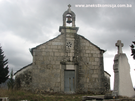
St
Elijah's church is probably of the kind known as a sepulchral church(3). It was built on the very summit
of Ilijino brdo, on a plateau with an area of more than 350m². The plateau has
a dry-stone retaining wall with a height of 1 to 1.5 m, with steps to the
north-west and east.
The
church is triconchal in plan. Triconchal churches belong to the central
type of building, though they are often found with a rectangular extension to
the west of greater or lesser extent.(4)
The
church measures about 10.00 x 5.50 metres and lies east-west. It most closely
resembles the church
of SS Peter and Paul in
Ošanjići near Stolac.
The entrance
to the church is at the west end, and is accentuated by a stone portal, a
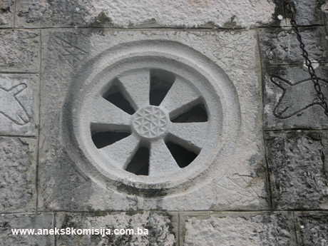
bellcote and a single oculus with a perforated six-lobed rosette midway between
the top of the portal and the base of the bellcote. The rosette is framed by
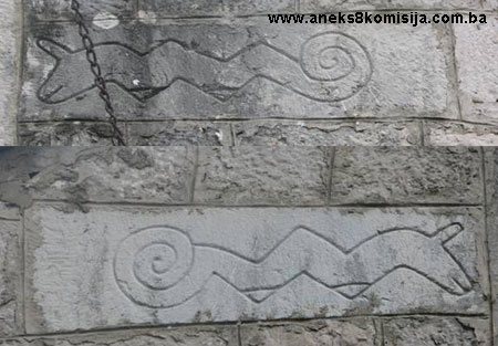
two rectangular stone plaques with a bas relief of two dragons affrontés.
The stone
entrance portal is almost in the axis of the church, and consists of two
massive doorjambs, 1.65 m in height, and a rectangular architraval lintel about
60 cm high and 1.50 m long, on which the inscription on the renovation
of the church is carved: IC XPC XPM C I OПЋ ПОН, 1897 The stone blocks of the
portal are about 26 cm thick. Above the lintel is a stone drip cap 1.40 m wide
and about 20 cm in height, the base of which rests on the top of the door
lintel, where it is 120 cm wide. An iron door leads into the church.
The
interior of the church consists of the main nave, side apses and the altar
space. The central nave is barrel-vaulted, and the altar and side apses
are covered with semi-calottes. Structurally, the load of the vault is transferred
direct to the side bearing walls.
The apses
are 1.50 m from the south and north corners of the church respectively. The
side apses measure 5.80 in circumference on the outside, while the central apse
is slightly smaller at 5.65 m. Light enters the church through three
round-arched windows in the north, south and east apses. The daylight
measurements of these windows are 0.28 m wide by 0.53 m high. The stone blocks
are decorated with floral designs and crosses.
The altar
space contains the high altar, and there are two niches in the prothesis in
the north wall, in the lower of which is a built-in carved marble stoup with a
diameter of 13 cm and a depth of 8 cm. There are two shallow niches in the
walls of the north and south apses.
The bellcote,
with a single opening housing a bell, stands at midpoint over the frontispiece
of the church. Bell cotes of this type are one
of the main features of small churches of this type in Dalmatia and Herzegovina.
The bellcote is about 1.20 m and consists of two stone pillars with a marked
transition to the arched section of the bellcote, which has a bas relief
moulding. The motifs in the medallions are mainly floral. The bellcote arch is
semicircular. The bellcote was built of dressed stone.
Like
other buildings of this type in Herzegovina,
the material used to build this church is limestone. The blocks are
rectangular-cut, measure 25-30 cm in height, are well-finished on the outside
and laid in roughly even courses. The horizontal and vertical joints of the
stone blocks are not as precise as those of other churches in Popovo plain 9the
church in Veličani, the church in Taleža). The blocks are laid in lime mortar.
The walls are about 60 cm thick.
The
church is mostly clad with tiles, but the apses were flush-clad with stone.
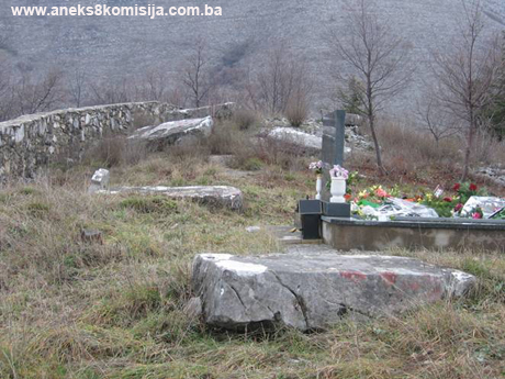
There are
no graves on the church plateau except for one at the west end outside the
church, where priest Jovan Popović was buried in 1913 after serving as priest
for 39 years, along with his wife Ane. Their grave lies west-east. To the left
of it, by the plateau wall, is the broken cross of Marija Miličević. There is
another stone cross, also broken off, on the plateau behind the east end of the
church, with a Cyrillic inscription which Ljubo Sparavalo claims gives the year
when the church was built or renovated.
The stone
cross with a Cyrillic inscription is also the cross that originally topped
the east gable of the church and is now lying broken against the wall of the
plateau, to the north of the east steps leading up to the plateau. It is large
and ungainly, poorly worked in relatively pure limestone, and is 60 cm high and
7 cm thick. The mediaeval inscription carved in Cyrillic is on its west face. A
small crux decussata was carved at the very top of the upright of the
cross. A diacritical mark over the lower arm of the cross indicates that the
word below it is an abbreviation; this has two letters I C, short for ИСУС
(Jesus). At the other end of the arm is a capital X with diacritical mark,
short for ХРИСТОС (Christos).
The
left-hand cross arm bears a carved sign with diacritical mark in the corner,
consisting of two letters joined at the centre by a vertical line: the letters
NH, with a diacritical mark over them. They are separated from the previous
letters by a single dot at mid-height of the line: the letters KA, the second
part of the word NHKA (victorious). This Greek word is also divided into two letters,
set at the ends of the cross arms. Two letters separated from the KA by a dot,
and which proved the hardest to decipher, are the Greek letter psi Ψ with the Cyrillic
letter B to the right of it, laid horizontally and with the two right-hand ends
not joined up. There is a diacritical mark over the letters, and a dot at the
end at mid-height of the line. This indicates that these two letters are of numerical
value.
The cross
is not carved into the stone, but stands proud. The formula IC X NHKA is
usually carved on tombstones and the memorials to the founders of churches. Christian
tradition has it that this kind of inscription, symbolizing Christianity
victorious, first appeared during the reign of Constantine the Great, in the 4th century (Lj.
Sparavalo, 1977, 131 – 133).
Cruciform
tombstone of Marija Milićević. This cross, cut from soft
limestone, is on the plateau outside the west end of the church. Above ground
level the cross is 60 cm high, with cross arms 47 cm long; the cross it 10 cm
thick and the arms are 17 cm wide. All three arms bear a single carved orb on
the sides. The Cyrillic epitaph begins at the top of the upright and ands in
the middle of the cross, where there is a small carved cross.
The
epitaph on the cruciform tombstone reads: Marija, daughter of Vukosav
Ostojić, wife of Mihail Milićević. May god forgive her. 1706.
The
epitaph is of interest for the study of the history of Cyrillic in the
epigraphy of Bosnia and
Herzegovina (Lj. Sparavalo, 1977, 139 –
142).
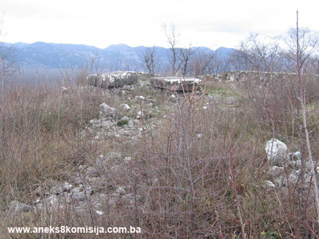
Prehistoric grave mound (tumulus)
This is
in the western part of the necropolis. The boundary wall of the burial ground
was built over it. The mound has a diameter of about 30 metres, and is two or
three metres high; it is overgrown with grass, low thorny scrub and weeds.
There are small intermittent traces of mortar at the top, probably the remains
of a tomb, typical of this region. A narrow bank forms a slight arc at the
northern end of the necropolis. On the south side of the bank, too, there are
old graves; there was presumably once a prehistoric grave mound there too. It
is believed that there were three prehistoric grave mounds there at one time,
of which only one still survives.
Necropolis with stećak tombstones
on Ilijino brdo
All the
stećak tombstones are equally roughly cut and in a poor state of preservation,
so that it is impossible to date them even approximately. There are ten in all,
in two groups. Of one group, which was outside the present-day church of St Elijah, only one amorphous stećak now
remains, still outside the church. Three stećak tombstones have been built into
the plateau wall on the west side. If the retaining wall was built in 1494,
like the church, these stećak tombstones must be older than the church, and it
would be fair to say that all of the stećak tombstones in this necropolis
predate the church, i.e. before the end of the 14th century.
The other
group of stećak tombstones is at the western end of the necropolis, on the
prehistoric grave mound. Nine have survived in this group, including one with a
carved crucifixion; the remains of decorations can also be seen on some of
them.
Only
three of the stećak tombstones on the mound itself are not lying west-east. In
this group too the tombstones have been partly destroyed, and used to make the
doorjambs of the north-west gateway into the burial ground. On one of them the
single letter X (probably all that remains of the inscription IC X NHKA) is
lightly incised. The isolated stećak close to this gateway was decorated, but
the decoration is now difficult to make out.
It would
seem that each of these groups of stećak tombstones had its own separate
church, probably before 1494. The first was where the present-day church of St Elijah stands, and the other where
there is now a small outbuilding used to prepare for funerals (measuring 4.55 x
2.35 on the inside). Since there is no local tradition about this or about the
construction of the boundary wall of the burial ground or of the cistern, they
must all have been built a long time ago. Observations made when studying other
mediaeval necropolises in the Trebinje
Forest region suggest
that there was a church with each of the groups of stećak tombstones in this
necropolis.
The
remains of old bricks found when digging graves for the modern cemetery suggest
that this necropolis was a religious site even earlier. Đuro Basler examined
this material and found that it could be from a Roman temple (Lj. Sparavalo,
1977, 149-151).
All the
stećak tombstones are equally roughly cut and in a poor state of preservation,
so that it is impossible to date them even approximately. There are eight in
all, seven of them at the western end of the necropolis, on the prehistoric
grave mound. They include a stećak with a carving of the crucifixion; the
others show no signs of having been decorated. The isolated stećak is in the
northern part of the necropolis. Another three have been built into the plateau
wall on the west side. Six of the stećak tombstones are chest-shaped, and two
are slab-shaped. They are not in rows but arranged haphazardly, lying
west-east, except for three that are lying north-south.
Stećak
no.1 – slab, the stećak measures 165 x 90 x 30 cm, lying north–south,
of poor workmanship and damaged,
Stećak
no. 2 – chest-shaped, the stećak measures 130 x 110 x 34 cm, lying
north–south, of poor workmanship and damaged,
Stećak
no. 3 – chest-shaped, the stećak measures 182 x 87 x 50 cm, lying north–south,
of poor workmanship, damaged and mounted on stones,
Stećak
no. 4 – chest-shaped, the stećak measures 190 x 86 x 35 cm, lying west–east,
of poor workmanship, damaged and covered with lichens,
Stećak
no. 5 – slab, the stećak measures 180 x 73 x 30 cm, lying west – east,
of poor workmanship and damaged,
Stećak
no. 6 – chest-shaped, the stećak measures 185 x 105 x 33 cm (visible
height), lying west–east, of poor workmanship and damaged, sunken and overgrown
with grass. A decorative motif can be made out on the horizontal surface; a
carved cross, with three of the arms ending in circles. An old, decorated
cruciform tombstone is leaning up against the west right-hand corner of the
stećak,
Stećak
no. 7 – chest-shaped, the stećak measures 173 x 76 x 33 cm (visible
height), lying west–east, with the east side sunken and overgrown with grass. Of
better workmanship than the other stećak tombstones,
Stećak
no. 8 – chest-shaped, the stećak measures 207 x 90 x 42 cm, lying west–east,
mounted on stone, of poor workmanship and damaged,
Stećak
with relief scene of the crucifixion. A stećak with a cross carved
onto the horizontal face, made of some darkish limestone, stands at the western
end of the necropolis. Like most of the stećaks in this region, the west end is
slightly wider (110 cm) than the east (83 cm). It is 180 cm long in the middle,
and varies in height from 35 to 40 cm. It is lying west-east. The carved crucifixion
on this tombstone is 80 cm long and 78 cm wide.
A halo
was carved around Jesus' head, the arc of which can still be made out. There is
no inscription above it, nor can the wooden cross on which Jesus was crucified
be seen. Jesus' head is facing forward, and has short curly hair not falling
over his shoulders. There is indeed quite a wide space between the hair and the
shoulders. The face is hard to make out, because the stone is badly worn at
this point, and the eyes, nose and forehead are barely visible. The face ends
at the chin with a wide protuberant arc representing a short, wide beard.
The arms
are widespread and clumsy, with the shoulders, muscles, elbows and fingers
indistinguishable. The ends of the arms look like hewn timber, with holes that could
represent the nails with which the hands were nailed to the wooden cross. Jesus'
body is standing upright; on his bare chest are two protuberances representing
the nipples, damaged in places. The lower part of the body is swathed in cloth
to the feet, like an Egyptian mummy, with even the feet hidden. There are holes
at the end of the cloth that, as with the hands, could represent nails.
The fact
that the head is not slumped onto the right shoulder, the hands are not limp,
and the hips are not sagging to the right, as well as that Jesus is standing
upright, suggest that he was represented not as the dead Christ but as still
living. Crucifixions carved in stone have been found in Dalmatia.
The fragments of one crucifixion were first found in Biskupija near Knin, and
are thought to date from the early 12th century.
A
fragment of another crucifixion was found in Burnaze near Sinj. This consisted
of the top part only of a stone cross with part of Jesus' head with a halo.
This crucifixion has been dated to the 8th to 9th century. Both were part of
church fittings, probably on the altar partition. Figures of the living Christ
on the cross belong to the beginnings of Christian iconography, and this type
of crucifixion is believed to originate from the Palestinian-Syrian cultural
circle. It was only in the 11th century that figures of the dead Christ on the
cross began to appear in Byzantium and
trans-alpine Europe, and not until the 13th that they first featured in Italy
(Lj. Sparavalo, 1977, 144 – 148).
Burial ground
The
burial ground is surrounded by a stone boundary wall, with the entrance to the
north. There are the remains of graves throughout the area except on the
plateau, where there is just the one grave already referred to. The burial
ground contains 31 old cruciform tombstones, some small, some slightly larger,
with decorations. Three are lying on the ground, and some are leaning up
against other graves, or even against stećak tombstones. The cruciform
tombstones date from the late 19th century. They were erected over the head of
the deceased, facing east. They are all of modest size, with none more than
1.20 m in height, and most 70-80 cm in height, 30-50 cm wide and 25-35 cm
thick.
The
tombstones show signs of meticulous stonemasonry, particularly in the case of
those of which the arms end, in most cases, in hemispherical protuberances, or
in some cases in the floral ornaments to be found in Herzegovina wood carvings. The
front of the crosses is often decorated with a rope-twist around the edges of
the arms, combined with zigzag lines and astragals. The empty spaces are filled
with rosettes and six-pointed stars, and finally the greatest care was bestowed
on the cross, as a symbol. This is usually decorated with a variety of
ornaments, and the arms end in trefoils. Nothing is known of the stonemasons
who made these tombstones; none of them left anything about themselves on any
of the tombstones, not even a signature. The burial ground also contains some
tombs of more recent date, mainly family tombs with large decorated tombstones
facing east.
3. Legal status to date
During
the procedure prior to the adoption of a final decision on designation, the
records on the protection of the property were inspected and the findings are
as follows:
In the
Regional Plan for BiH to 2000, 72 sites of necropolises with stećak tombstones
(2406 in all) are listed in Trebinje Municipality as Category II monuments,
without identifying them more accurately (various authors, 1980, 52).
A letter
from the Institute for the Protection of Monuments of the Federal Ministry of
Culture and Sport dated 14 December 2007 states that the property is listed but
was not in the Register of Cultural Monuments of the Institute for the
Protection of the Cultural, Historical and Natural Heritage of Bosnia and Herzegovina.
The
prehistoric hill fort with tumuli and fortifications on Ilijino brdo and the
church of St Elijah and mediaeval burial ground in the village of Mesari,
Trebinje Municipality, are on the Provisional List of National Monuments of the
Commission to Preserve National Monuments under serial nos. 708
and 707.
4. Research and conservation and
restoration works
In the
spring of 1960, the Institute for the Protection of Cultural Monuments
of BiH began systematically studying the stećak tombstones in Popovo plain. The
field work was completed in 1964, and was followed by sorting and
studying the materials.
Šefik
Bešlagić states that there is a necropolis in the village of Mesari,
beside the Orthodox church of St Elijah, with seven stećak tombstones, five
chest-shaped and two slabs (Š. Bešlagić, 1971, 398).
In 1977
Ljubo Sparavalo conducted investigative works with a detailed description
of the existing condition of the prehistoric grave mound, the necropolis with
stećak tombstones, the stone crosses and the church of St Elijah
(Tribunia 3, 1977, 123 – 152).
According
to the information provided by Lj. Sparavalo, the renovation works on the
church in 1897 were carried out by the Đordani masons of the village of Dvrsnica in Popovo. They rebuilt the
west façade, the frontispiece of the church, and built and erected the
bellcote; they also reroofed the church and carried out other minor works. Until
then the church bell had hung from a maple tree near the north-west steps
leading up to the plateau. The stone rosette, dragons and altar window were
also made at that time. During the re-roofing of the church the stone cross
with the Cyrillic inscription was removed from the top of the east gable and
set against the wall of the plateau by the east steps.
No other
works that might have altered the previous appearance of the church have been
carried out. The floor in the church was replaced in the late 1820s,
when a rectangular "izba" tomb containing a human head, was found
when the floor was lifted. The church
of St Elijah is also a
parish church, since the parish headquarters were in Mesari.
All
interventions since then have been carried out by the local people.
5. Current condition of the
property
The
findings of an on site inspection on 17 January 2008 are as follows:
-
The site of the
necropolis, and in particular the area of the prehistoric grave mound and stećak
tombstones, is overgrown with thorny scrub, weeds and trees
-
The stećak tombstones are
deteriorating rapidly as a result of lack of maintenance
-
Most of the stećak
tombstones are of poor workmanship and poorly preserved, and are mounted on
stones
-
Stećak no. 1 is damaged
-
Stećak no. 2 is also
damaged and chipped
-
Stećak no. 3 is damaged on
the east side and is in poor condition
-
Stećak no. 4 is tilted to
the south, is covered with lichens, and has a woody plant growing out of the
east front end
-
Stećak no. 5 is of poor
workmanship and damaged
-
Stećak no. 6 is sunken and
overgrown with grass to north and south, and is decorated with a carved cross
-
Stećak no. 7 is sunken and
overgrown with grass to the east, but on the west side it can be seen to be
mounted on stones
-
Stećak no. 8 is of poor
workmanship and also mounted on stones
-
The ornamentation on the
stećak tombstones cannot be made out, except for the one already referred to
-
The entire site of the
National Monument is occupied by a modern Orthodox cemetery
-
The area outside the walls
of the property is covered in shrubs and small trees typical of the Herzegovina
region
-
The church is a risk from
lack of maintenance and rising damp
-
The roof cladding of the
church is of unsuitable building material
6. Specific risks
-
deterioration resulting
from long years of lack of maintenance of the site
-
adverse weather conditions
-
self-sown vegetation
-
active burials
III – CONCLUSION
Applying
the Criteria for the adoption of a decision on proclaiming an item of property
a national monument (Official Gazette of BiH nos. 33/02 and 15/03), the
Commission has enacted the Decision cited above.
The
Decision was based on the following criteria:
A. Time frame
B. Historical value
C. Artistic and aesthetic value
C.iii. proportions
C.iv. composition
C.v. value of details
C.vi. value of construction
D. Clarity
D.i. material evidence of a lesser known
historical era
D.iv. evidence of a particular type, style or
regional manner
E. Symbolic value
E.i. ontological value
E.ii. religious value
E.iii. traditional value
E.iv. relation to rituals or ceremonies
E.v. significance for the identity of a group of
people
F. Townscape/landscape value
F.iii. the building or group of buildings is part
of a group or site
G. Authenticity
G.i. form and design
G.ii. material and content
G.iii. use and function
G.iv. traditions and techniques
G.v. location and setting
G.vii. other internal and external factors
H. Rarity and representativity
H.i. unique or rare example of a certain type
or style
I. Completeness
I.iii. completeness
The
following documents form an integral part of this Decision:
-
Copy of cadastral plan
-
Copy of land register
entry
-
Photodocumentation
(photographs taken on site)
Bibliography
During
the procedure to designate the monument as a national monument of Bosnia
and Herzegovina the following works were
consulted:
1889 Mihajlović, Hristifor (abbot). "Popovo u Hercegovini"
(Popovo in Herzegovina), Jnl
of the National Museum vol. I, yr I. Sarajevo: January-March
1889
1963 Subotić, Gojko. Arhitektura i kultura srednjeg vijeka u
Primorju (Mediaeval Architecture and Culture in the Coastal Regions). Belgrade: Institute for the Publication of Textbooks of
the Socialist Republic
of Serbia,
1963
1966 Bešlagić, Šefik. Popovo, Srednjovjekovni nadgrobni spomenici
(Popovo, Mediaeval Tombstones). Sarajevo:
1966
1971 Bešlagić, Šefik. Stećci, kataloško-topografski pregled
(Stećak tombstones, a catalogue and topographical survey). Sarajevo: Veselin Masleša, 1971
1977 Sparavalo, Ljubo. “Srednjovjekovna crkva i groblje na Ilijinom
brdu kod sela Mesari blizu Trebinja” (Mediaeval
Church and Burial Ground on Ilijino
brdo by the village
of Mesari near Trebinje),
Tribunia 3. Trebinje: 1977
1978 Odavić, Đorđo. “Praistorijska nalazišta na području Trebinja
(gomile i gradine)” (Prehistoric Sites in the Trebinje Area [Barrows and Hill
forts), Tribunia 4. Trebinje: 1978
1980 Various authors. Regional Plan for Bosnia and Herzegovina; Stage B -
valorization of natural, cultural and historical monuments. Sarajevo: Institute for architecture, town planning and
regional planning of the Faculty of Architecture in Sarajevo
and Town Planning Institute for BiH, Sarajevo,
1980
1983 Bojanovski, Ivo. “Trebinje – Rimsko Asamo (Asamum) s kratkim
osvrtom na Ager kolonije Epidaura” (Trebinje – Roman Asamo [Asamum] with brief
reference to the Ager colony of Epidaurum), Tribunia 7. Trebinje: 1983
1983 Anđelić, Pavo. “Srednjovjekovna župa Popovo” (Mediaeval County
of Popovo), Tribunia 7. Trebinje: 1983
1984 Đurić, Vojislav. Počeci
umjetnosti kod Srba, Umjetnost na tlu Jugooslavije, Rani srednji vijek
(Beginnings of Art among the Serbs, Art in Yugoslavia, Early Mediaeval
Period). Ljubljana,
Delo, 1984
1985 Bojanovski, Ivo. “Ilirska plemena u istočnoj Hercegovini i
njihov smještaj” (The Illyrian Tribes of Eastern Herzegovina and their
Location), Tribunia 9. Trebinje: 1985
1998 Tošić, Đuro. Trebinjska oblast u srednjem vijeku (The
Trebinje District in Mediaeval Times). Belgrade:
Institute of History,
Serbian Academy of Sciences and Arts, special
edition, vol. 30, 1998
2002 Ševo, Ljiljana. Pravoslavne crkve i manastiri u Bosni i
Hercegovini do 1878 godine (Orthodox Churches and Monasteries in BiH to
1878). Banja Luka:
2002
2007 Lovrenović, Dubravko. Stećci – bosansko i humsko mramorje
srednjeg vijeka (Stećak Tombstones – The Mediaeval Marbles of Bosnia and
Hum). Sarajevo:2007,
in print
(1) This cross originally
topped the east gable of the church
(2) The inscription
is an abbreviation of the Christogram, meaning that Jesus Christ is victorious,
also suggested by the tomb of an unknown person buried in the church. The founder of a church – whether the original
builder or the person who later rebuilt or renovated it – had the right to be
buried inside the church (Lj. Sparavalo, 1977, 129, 134, 136).
(3) Ševo, 210
(4) Triconchal
churches fall into two groups. The first consists of buildings with side conchs
adjoining the nave. There are examples of these in the eastern Balkans, in
northern Illyrian towards Dalmatia. The oldest
are in Tephulj, near Bar, followed by 6th century examples – the Empress’s
City, Kuršumlija. The second group is represented by buildings where the nave
adjoins a triconch. These are grouped in western Dalmatia.
A somewhat more recent building is located in Cim, near Mostar. The church of St. Peter in Ćićevo dates from the first
half of the 12th century. Here the builder added two conchs, one on the north
and one on the south wall, to the rectangular building with apse; these conchs
are three-sided on the exterior. There is a parvis on the west side, with the
main entrance on the south side. The church
of St Paul in Dživar,
near Trebinje, dating from the 12th century, also belongs to the triconchal
group, where the conchs are semicircular on the inside and trapezoid on the
outside. In this case the conchs are
arched, and the remaining area had a gabled timber roof (V. Jovanović, 74, 75).
The church of the Lapušnja monastery is of fully developed triconchal plan,
with a pronounced altar space and separate diaconicon and proscomidion, a large
dome and a parvis wider than the cella (S. Petković,
17-19). All these churches, with their
roughly cruciform outward appearance, and where the interior consists of
different spatial versions of the triconchal plan, are a mediaeval derivative
of the much more complex early-Byzantine apostolic churches, such as the church of St. John
in Ephesus and the church of the Holy Apostles
in Istanbul. In
the Byzantine tradition, ever since the church of the Holy Apostles in Istanbul, triconchal
churches are usually apostolic (churches dedicated to the apostles), as is the
case of the church in Ošanići.
It is particularly common for the principal church of the great
Orthodox monasteries on Mt Athos to be built to a triconchal plan, with the
side conchs serving a very specific purpose – as choirs large enough to
accommodate numerous monks during the liturgy. The triconchal type of church
which is so common in the religious architecture of Moravian Serbia (late 14th
and first half of the 15th century) is thought to reflect the influence of Mt
Athos, and the frequent appearance of the triconchal plan in religious architecture
in Wallachia and Moldavia in the 15th to 17th centuries is seen as resulting
from the influence of Moravian Serbia.
Churches of this type continued to be built even later, as is the
case with the Papraća monastery on the source of the river Spreča, mid-way
between Zvornik and Šekovac, with the church of the Annunciation dating from
1540, as was the monastery churches of Moštanica in Potkozarje, both dating
from the early Ottoman period – 15th or 16th century. Papraća and Moštanica are buildings of
extended triconchal plan with a dome, parvis and spacious exterior parvis.
The exterior dimensions of the church of SS Peter
and Paul in Ošanići, including the parvis, are 13.60 m in length and 5.35 m in
width. The open parvis, which is contemporary with the church, measures 5.35 x
2.90 m. The north side of the portico is enclosed by a stone wall, while the
south side is open. The roof structure is supported by a substantial cross beam
on the south side, which in turn is supported by two timber columns of circular
cross-section with head trees, standing on simple four-sided stone bases. In
the interior, the building is 3.75 metres wide and 9.25 metres long. The entire
building is covered by a barrel vault, approx. 4.85 metres in height measured
in the central part of the church. The walls of the building are made of
rough-hewn stone and vary in thickness. The west wall is 68-70 cm thick; the
north and south walls are rather more massive with a thickness of 80 cm. These
walls have two symmetrically-placed windows facing one another, the one in the
north wall 60 cm in width and the one in the south wall 70 cm in width (for
more, see the Decision designating the architectural ensemble of the church
of SS Peter and Paul as a national monument of BiH).