Published
in the “Official Gazette of BiH”, no. 1/10.
Pursuant
to Article V para. 4 Annex 8 of the General Framework Agreement for Peace in Bosnia and Herzegovina
and Article 39 para. 1 of the Rules of Procedure of the Commission to Preserve
National Monuments, at a session held from 20 to 27 November 2007 the
Commission adopted a
D E C I S
I O N
I
The
industrial heritage of the production of salt in Tuzla is
hereby designated as a National
Monument of Bosnia and Herzegovina
(hereinafter: the National Monument).
The
National Monument consists of three groups:
1. the
old Kreka salt works with chimney, workshops and rare materials warehouse, the Salt Museum
with movable heritage,
2. the
complex of brine wells and pumping station,
3. a
brine well dating from the Ottoman period.
Group 1,
the old Kreka salt factory with chimney, workshops and rare materials
warehouse, is located on a site consisting of the following cadastral plots:
-
c.p. 3182/3, cadastral
municipality Tuzla I (new survey)(1) corresponding to c.p. 2081/2,
c.m. Tuzla (old
survey),
-
c.p. 3182/9, c.m. Tuzla I (new survey)(2) corresponding to c.p. 2082/6, c.m. Tuzla (old survey),
-
c.p. 3191/2, c.m. Tuzla I (new survey)(3) corresponding to c.p. 2087/3
(old survey),
-
c.p. 3182/17, c.m. Tuzla I (new survey)(4) corresponding to c.p. 2072/5
(old survey),
-
c.p. 3182/18, c.m. Tuzla I (new survey)(5) corresponding to c.p. 2072/4
(old survey).
Group 2,
the complex of brine wells and pumping station, is located on a site consisting
of the following cadastral plots:
-
c.p. 2634, c.m. Tuzla II
(new survey)(6) corresponding
to c.p. 6/599, c.m. Tuzla
(old survey),
-
c.p. 2623, c.m. Tuzla II
(new survey)(7) corresponding
to c.p. 6/295, 6/296 (old survey),
-
c.p. 2862, c.m. Tuzla II
(new survey)(8) corresponding
to c.p. 6/790 (part), 6/287 (part), 6/562 (part), 6/285 (part), 6/776, 6/773,
6/774, 6/776 c.m. Tuzla
(old survey),
-
c.p. 2620, c.m. Tuzla II
(new survey)(9) corresponding
to c.p. 6/293 (part0 (old survey),
-
c.p. 2619, c.m. Tuzla II
(new survey)(10) corresponding
to c.p. 6/539 (old survey),
-
c.p. 2611, c.m. Tuzla II
(new survey)(11), 2612,
2613, c.m. Tuzla II (new survey)(12) corresponding to c.p.
6/815? (old survey),
-
c.p 2859, 2861 c.m. Tuzla
II (new survey)(13) corresponding
to 6/285 (part), 6/562 (part), 6/164 (part), 6/166 (part), 6/768 (part), 6/287
(part), 6/780 (part), 6/192 (part), c.m. Tuzla
(old survey),
-
c.p. 2598, 2597 c.m. Tuzla
II (new survey)(14) corresponding
to c.p. 6/287, 6/286, 6/766 (part), 6/562 (part), 6/285 (part), 6/193 (part),
6/633 (part), 6/211 (part), 6/765, 6/764, 6/763, 6/762, 6/761, 6/524, 6/525
c.m. Tuzla (old
survey),
-
c.p. 2557, c.m. Tuzla II
(new survey)(15) corresponding
to c.p. 6/281 (part) (old survey),
-
c.p. 2568, c.m. Tuzla II
(new survey)(16) corresponding
to c.p. 6/688 (part) (old survey),
-
c.p. 2566, c.m. Tuzla II
(new survey)(17) corresponding
to c.p. 6/960 (old survey),
-
c.p. 2567, c.m. Tuzla II
(new survey)(18), 2556,
c.m. Tuzla II (new survey)(19) corresponding
to c.p. 6/959 (old survey),
-
c.p. 2555, c.m. Tuzla II
(new survey)(20) corresponding
to c.p. 6/786 (part) (old survey),
-
c.p. 2554, c.m. Tuzla II
(new survey)(21) corresponding
to c.p. 6/787 (part), 6/788 (old survey),
-
c.p. br. 2546, c.m. Tuzla
II (new survey)(22),
corresponding to c.p. 6/969, 6/970, 6/971, 6/973, 6/974, 6/975, 6/976, c.m. Tuzla (old survey),
-
c.p. 2549/1, c.m. Tuzla II
(new survey)(23), 2547/2,
c.m. Tuzla II (new survey)(24), 2547/1,
c.m. Tuzla II (new survey)(25),
corresponding to c.p. 6/357, 6/916, 6/446 (old survey).
Group 3,
the brine well dating from the Ottoman period, is located on a site consisting
of the following cadastral plots:
-
c.p. 288/1, c.m. Tuzla II
(new survey)(26) corresponding
to c.p. 5/181, 5/183, 5/184, 5/196, 5/197, 5/199, 5/220, 5/221, 5/222, 5/230
(old survey) and c.p. 288/2, c.m. Tuzla II (new survey)(27) corresponding to c.p. 5/400, 5/399 (old
survey)
The
provisions relating to protection measures set forth by the Law on the
Implementation of the Decisions of the Commission to Preserve National
Monuments, established pursuant to Annex 8 of the General Framework Agreement
for Peace in Bosnia and Herzegovina (Official Gazette of the Federation of BiH
nos. 2/02, 27/02 and 6/04) shall apply to the National Monument.
II
The
Government of the Federation of Bosnia and Herzegovina (hereinafter: the
Government of the Federation) shall be responsible for providing the legal,
scientific, technical, administrative and financial measures necessary for the
protection, conservation, restoration, and presentation of the National
Monument.
The
Commission to Preserve National Monuments (hereinafter: the Commission) shall
determine the technical requirements and secure the funds for preparing and
setting up signboards with basic details the monument and the Decision to
proclaim the property a National Monument.
III
To ensure
the on-going protection of the National Monument, the following protection
measures are hereby prescribed:
-
a programme shall be drawn
up to produce planning projects for the groups for which area planning
documentation has not been drawn up, to ensure that the integrity and
legibility of the National Monument are preserved, determine the potential for
the development of salt production using modern methods in a manner that will
not endanger the National Monument, and identify ways in which the groups might
be linked in order to present the production of salt.
In regard
to the separate groups constituting the National Monument, the programme for
the production of planning projects should include:
-
for group 1, create a
dedicated access to the old Kreka salt works with chimney and workshops and
rare materials warehouse and the Salt
Museum, from XVIII
hrvatske brigade street on the northern boundary of the site. This shall be
kept separate from the other facilities within the factory precincts of Solana
d.d. Tuzla, so
as to ensure controlled and unimpeded access for visitors
-
for group 2, erect a
barrier around the protected site specified in Clause 1 para. 4 of this
Decision; set the boundaries of the protected site to coincide with the
boundaries of the industrial heritage defined on the map Kompleks kulturni
krajolik Panonskog jezera Tuzla (Complex of the cultural landscape of the
Pannonian lake, Tuzla) scale 1:1000, which forms an integral part of this
Decision
-
for group 3, prohibit
within a radius of 10 m from the boundaries of the protected site of group 3
the erection of buildings or facilities the appearance or operation of which
could be detrimental to the National Monument.
Repair,
remedial, conservation, restoration and revitalization works, and works
designed to present salt production and the historic significance of the
monument shall be permitted on the individual properties within the groups
constituting the National Monument.
Conservation
and restoration projects for the individual properties within the groups should
cover:
For the buildings in group 1:
Old Kreka salt works with chimney
and workshops:
-
damage to the walls,
pillars, interstorey structure, floors, surrounding wall/fence, steps, roof
structure and damaged roof cladding shall be made good, and the inside walls
shall be plastered and painted
-
conservation and
restoration works shall be carried out on the façades of the property, based on
original documentation and prior investigative works
-
the interior of the
workshops may be reconstructed, fitted and restored to their original condition
and function.
Rare materials warehouse to the
east of the old Kreka salt works:
-
conservation and
restoration works on the façades of the property
-
the interpolation of new
complementary components inside the property is permitted provided that they
are not detrimental to the original appearance of the property.
Salt Museum
building:
-
repair and conversion
works designed to integrate it functionally with the old Kreka salt works and
rare materials warehouse.
For the buildings in group 2: the
complex of brine wells and pumping station:
-
the damaged roof structure
and roof cladding shall be repaired, after first conducting investigative works
to determine the cause of the appearance of cracks on the south-west corner of
the building
-
structural repairs to the
south-west corner
-
routine maintenance works
on the well towers shall be carried out.
For the Ottoman-period brine well
-
the installation of a
climate control system to ensure optimal moisture content (50-60%) and air
temperature (16° do 22° C)
Suitable
physical and technical conditions for the safe-keeping of the production
technology in the old Kreka salt works and the movable heritage in the Salt Museum,
and in particular:
-
conservation and
restoration works shall be carried out on all the production plant and metal
items to prevent further corrosion and to protect them from further
deterioration
-
suitable museum conditions
shall be provided for housing metal items to prevent their further
deterioration, by installing a climate control system to ensure optimal
moisture content (50-60%) and air temperature (16° do 22° C) in the production
shed of the old Kreka salt works and the exhibition premises of the Salt
Museum.
The
display and other forms of presentation of the movable heritage in Bosnia and Herzegovina shall be effected under
the terms and conditions stipulated by the ministry of the Federation of Bosnia and Herzegovina
responsible for culture.
A
maintenance programme shall be drawn up for the various buildings and groups,
to include their presentation to the general public.
-
the use of multimedia
technical solutions is permitted for the purpose of presenting the old
technology used in the production process in the old Kreka salt works
-
all interventions on the
National Monument must have the prior approval of the federal ministry
responsible for regional planning and be carried out under the expert
supervision of the heritage protection authority of the Federation of Bosnia and Herzegovina.
IV
All
executive and area development planning acts not in accordance with the
provisions of this Decision are hereby revoked.
V
The
removal of the movable heritage items forming part of the National Monument
(hereinafter: the movable heritage) from Bosnia and Herzegovina is
prohibited.
By way of
exception to the provisions of the preceding paragraph, the temporary removal
from Bosnia and Herzegovina
of the movable heritage for the purposes of display or conservation shall be
permitted if it is established that conservation works cannot be carried out in
Bosnia and Herzegovina.
Permission
for temporary removal under the conditions stipulated in the preceding
paragraph shall be issued by the Commission to Preserve National Monuments, if
it is determined beyond doubt that it will not jeopardize the movable heritage
in any way.
In
granting permission for the temporary removal from Bosnia and Herzegovina of
the movable heritage, the Commission shall stipulate all the conditions under
which the removal may take place, the date by which the property shall be
returned to the country, and the responsibility of individual authorities and
institutions for ensuring that these conditions are met, and shall notify the
Government of the Federation of Bosnia and Herzegovina, the relevant security
service, the customs authority of Bosnia and Herzegovina, and the general
public accordingly.
VI
Everyone,
and in particular the competent authorities of the Federation of Bosnia and
Herzegovina, the Canton, and urban and municipal authorities, shall refrain
from any action that might damage the National Monument or jeopardize the
preservation and rehabilitation thereof.
VII
The
Government of the Federation, the Federal Ministry responsible for regional
planning, the Federation heritage protection authority, and the Municipal
Authorities in charge of urban planning and land registry affairs, shall be
notified of this Decision in order to carry out the measures stipulated in
Articles II to VI of this Decision, and the Authorized Municipal Court shall be
notified for the purposes of registration in the Land Register.
VIII
The
elucidation and accompanying documentation form an integral part of this
Decision, which may be viewed by interested parties on the premises or by
accessing the website of the Commission (http://www.aneks8komisija.com.ba)
IX
Pursuant
to Art. V para 4 Annex 8 of the General Framework Agreement for Peace in Bosnia and Herzegovina,
decisions of the Commission are final.
X
This
Decision shall enter into force on the day following its publication in the
Official Gazette of BiH.
This
Decision has been adopted by the following members of the Commission: Zeynep
Ahunbay, Amra Hadžimuhamedović, Dubravko Lovrenović, Ljiljana Ševo and Tina
Wik.
No: 06.1-2-118/06-8
21 November 2007
Sarajevo
Chair of
the Commission
Ljiljana
Ševo
E l u c i
d a t i o n
I – INTRODUCTION
Pursuant
to Article 2, paragraph 1 of the Law on the Implementation of the Decisions of
the Commission to Preserve National Monuments, established pursuant to Annex 8
of the General Framework Agreement for Peace in Bosnia and Herzegovina, a
“National Monument” is an item of public property proclaimed by the Commission
to Preserve National Monuments to be a National Monument pursuant to Articles V
and VI of Annex 8 of the General Framework Agreement for Peace in Bosnia and
Herzegovina and property entered on the Provisional List of National Monuments
of Bosnia and Herzegovina (Official Gazette of BiH no. 33/02) until the
Commission reaches a final decision on its status, as to which there is no time
limit and regardless of whether a petition for the property in question has
been submitted or not.
On 31 May
2006 and 13 November 2007 Tuzla
Municipality submitted a
proposal to the Commission to designate as a national monument:
-
the old Kreka salt works
and Salt Museum
-
the cultural landscape of
the Pannonian lake in Tuzla
which includes a proposal to designate the brine wells and pumping station and
the Ottoman-period brine well.
Pursuant
to the provisions of the law, the Commission proceeded to carry out the
procedure for reaching a final decision to designate the Property as a National
Monument, pursuant to Article V of Annex 8 and Article 35 of the Rules of
Procedure of the Commission to Preserve National Monuments.
II – PRELIMINARY PROCEDURE
In the
procedure preceding the adoption of a final decision to proclaim the property a
national monument, the following documentation was inspected:
-
Data on the current
condition and use of the property, including a description and photographs,
data of war damage, data on restoration or other works on the property, etc.
-
The current condition of
the property.
-
Copies of cadastral plans.
-
Historical, architectural
and other documentary material on the property, as set out in the bibliography
forming part of this Decision.
The
findings based on the review of the above documentation and the condition of
the site are as follows:
1. Details of the property
Location
The Tuzla
basin, with which the salt deposits in Tuzla are associated spatially, lies
between Mt. Majevica to the north and the serpentine zone to the south, in the
area of the old deep rift in the lithosphere which now reveals itself in the
area between Teslić, Doboj, Gračanica, Živinice and Zvornik. The area is
bounded by the expanse of neogenic formations from Ugljevik to Đurđevik to the
south-east and Gračanica to Sočkovac to the north-west(28) (documentation of the Tušanj
salt mine).
The town
of Tuzla is in north-east Bosnia, on the flanks of Mt. Majevica.
The old
Kreka salt works in Tuzla
lies within the grounds of the Soli Tuzla salt works at no 3 Soli (Salt)
street, in the centre of town. The Solana Tuzla salt works is in the western
quarter of the town, between the river Jala to the south, Salt street to the
west, XVIII Croatian Brigade street to the north, and Mijo Kerošević street to
the east.
The Salt Museum
is located within the grounds of the Soli Tuzla salt works at no 3 Salt street, in a
building designed to store salt packaging. This building and that of the old
Kreka salt mine are interconnected.
The
pumping station and salt mines are located on Borić hill, to the north of Trnovac street and
east of Borić street.
The
Ottoman-period brine well is in the centre of the town of Tuzla, in Solni (Salt) square.
Historical information
Salt has
been produced in Tuzla
ever since the Neolithic period. Archaeological material, shards from pottery
vessels, found in the town of Tuzla
around the present-day Šarena mosque and square attest to the present of a
Neolithic settlement. These fragments consisted of the rim and parts of the
belly of a pot of which the rim curved inwards(29). Later, at the end of the 1st century BCE, what is now Bosnia and Herzegovina
was conquered by the Romans. There is no material evidence of brine having been
extracted from this part of the country, but the Romans called the town where Tuzla now stands “To
Salines”, meaning salt. The earliest written reference to the name of the town
is associated with a note by Constantine Porphyrogenitus in his De
administrando imperio, where he refers to Tuzla as an “inhabited town” by the name of
Salanes(30), commenting
that it lies within the state of prince Časlav (Buljugić, 1990, 12). However,
it is only during mediaeval times that the first evidence of salt production in
Tuzla appears(31). At that time Tuzla
belonged to the old Bosnian county
of Soli, which covered
the river Jala valley and the upper course of the river Spreče(32). The earliest written evidence
of salt in this part of the world dates from 1189 and was signed by Ban
(governor) Kulin and Dubrovnik
(Basler, 1975, 12). In 1225, King András II formally bestowed the county of Soli on Archbishop Ugrin of Kalocsa.
Somewhat later, in 1253, there is reference to the first trade in salt in this
part of the world. A trade agreement was entered into by Dubrovnik
and Bulgaria's
Tsar Mihajl Asen. In 1254 King Béla IV divided Bosnia into three banates, one of
which was the banate of Soli. He followed this in 1263 by uniting Usora and
Soli with Mačva into a separate vojvodina (duchy). During the reign of
László (Ladislaus, Ladislav) IV Kumanac (1272-1290), this region was ruled by
Ban Henrik, a foreign feudal lord probably appointed by the king of Hungary. The
Hungarian rulers granted the administration of the area to Serbia’s King Dragutin from 1284 to
1316 (Ćirković, 1964). The political situation in Soli became more
secure only with the reign of Ban Stjepan II Kotromanić (1322-1353), who styled
himself lord of “Soli and other districts,” as recognized by Dubrovnik in 1324. About thirty years later,
in 1356, Tvrtko I styled himself ban of “all Bosnia and the whole of Usora and
Soli.” After Bosnia was proclaimed as a kingdom, in 1377, Soli became part of
the title of the ruler, which was: “King of Serbia, Bosnia, Primorje [the
coastal region], Hum Land, the Western Marches, Donji Kraj, Usora, Soli,
Podrinje [the Drina valley] and [lands] theretowards” (Basler, 1975, 12).
There were two settlements at that time - Gradovrh(33) in the Solina valley and Grad(34) in Gornja Tuzla. Economic
development stagnated in this part of the world as a result of Bosnia's previously giving up salt production on
its own account here in favour of the Dubrovnik
monopoly; this in turn weakened the position of the county of Soli
as a whole. Nothing is known about salt production or the extraction of brine
during this period.
The county of Soli first came under Ottoman rule in
1460, at the same time as did Srebrenica and Zvornik. However, the Hungarians
launched a counter-offensive in 1464, and the town of Sol again came under Hungarian rule. The
Ottomans finally conquered it in 1474. The first census, conducted that year,
refers to it as Agac Tuzla(35), district
of Zvornik, and records it as a timar [type of feudal] holding. Three
years later, however, Tuzla
became an imperial has or holding [Ar. khas], evidence that some salt
production had begun. In 1478 the kadi of Zvornik began court proceedings to
offer a three-year lease on the production of salt in Donja Sol (Tuzla),and the
following year the brine springs in Gornja Sol (Tuzla) were also leased out (mukata
[from the Arabic muqataa']) for three years. Ottoman document record the
first leaseholders of the salt works, reis Mursela and reis Bahadir of Zvornik,
with Musa, captain of Zvornik, as their guarantor (Handžić, 1975, 19). Another
form of exploitation of the brine springs, in addition to short leases, was malikana
[derived from Arabic mulk, tenure or possession] or perpetual leasehold.
The difference between mukata and malikana is that malikana leaseholders could
bequeath real or movable property to other persons as heirs, whereas mukata was
a fixed-term lease in the name of a specific person. In 1548 the Ottoman
authorities issued a kanun-nama (legal document) for the two Tuzla nahijas of Gornja
and Donja Tuzla, setting out the provisions governing the production of salt(36). That year the annual state
revenues from salt amounted to 70224 akčas in Donja Tuzla and 59632 akčas in
Gornja Tuzla. The next item of information on Tuzla's
brine springs is to be found in the monograph Rumelia and Bosnia by the
Ottoman geographer and historian Hajji Kalfa, dating from the first half of the
17th century. Hajji Kalfa says of Tuzla:
“Memlahatsin (Soli, Tuzli), 24 days from Istanbul,
between Bosnia, Belgrade, Zvornik,
Gračanica and Srebrenica. There are two brine springs in the market square
there, hence its name, which means two springs in Arabic” (Ilić, Kulenović,
1978, 43).
Evidence
that there were brine wells in the Ottoman period can be seen in the brine well
in Salt Square
in Tuzla.
The
earliest details of the processing of brine into salt dates from the 17th
century, when Atanasije Georgice described three ways of processing brine(37):
1. The
brine is extracted from the ground, heated to boiling point and left to boil in
large iron pans until the salt separates out in the bottom. Pure, fine salt is
obtained by this process.
2. Deep
holes as big as “two persons in number” are filled with wood which is then
burned... “when the wood is red hot, earth soaked in brine [?] is added to the
pit. The hot smoke from the pit and the burning branches rapidly evaporate the
water and the dry salt is extracted from it. Care should be taken that the
flame and embers are not extinguished, but can always burst into flame again. By
pouring brine in this way until the fire is out, large lumps of dry salt
accumulate at the bottom of the pit.” (Ilić, Kulenović, 1978, 42). (Salt
obtained in this way is darker in colour and with an admixture of ash; it is
used as salt licks for livestock.)
3. Brine
is dripped through a wickerwork sieve. Since only a little water is poured onto
the wickerwork, the water rapidly evaporates, leaving crystalline salt in
situ(38). (Ilić,
Kulenović, 1978, 42).
In his
monograph on Bosnia, printed
in Paris in
1816, Amedée Chaumette des Fosses published the notes from his travels through
this part of the world in 1807 and 1808. Des Fosses observes that Bosnia imports
considerable quantities of salt, but that “nature has not left it without salt.
The brine wells in Tuzla
are evidence of this. At the bottom of the valley where Donja Tuzla lies are
seventy or eighty wells with a usual diameter of six feet. The water is usually
at a depth of four to five feet. When the water is evaporated off in large
salt-kettles, salt of the finest quality remains as a deposit. However, only
wealthy people can afford this salt, because little is produced and its price
is much higher than that of ordinary salt. The valley where Gornja Tuzla is
located, two hours beyond Donja Tuzla, also has forty to fifty brine wells
exploited in the same way.” (Ilić, Kulenović, 1978, 43)(39). In his Zemljopis i
poviestnica Bosne (Geography and History of Bosnia), published in Zagreb in
1851, Ivan Jukić notes that there are three wells in Donja Tuzla from which
brine is extracted and salt is later evaporated off. This salt, he says, is
known by the locals as “šapulja.” He too says that there is a town two hours
from Donja Sol with more brine wells (Jukić, 1953, 330).
In a
monograph entitled The Mineral Industry in Bosnia
and Herzegovina, published in Vienna in 1900, Franz Poech refers to the use
of brine and the production of salt. His book includes a drawing of a complete
salt works, and an explanation of how it operates: “The brine from a small
spring in the ground is heated over fire in a large salt-kettle, 1.5 m in
diameter, below which a wood fire is laid. From time to time, brine is poured
into the bottom of the salt-kettle.” (Ilić, Kulenović, 1978, 45).
Generally
speaking, salt works in the Ottoman period were simple one-room wooden
structures measuring about 4.5 x 4.5 m, large enough for two furnaces at the
most with pans, accoutrements and tools. Simple tools were used to process the
brine: a pan, a trivet, something to stir the water with, a wooden bucket and a
barrel. The tools were made of poplar, maple, willow or walnut wood, since wood
is resistant to corrosion. According to information gathered from various
Ottoman documents, at the end of Ottoman rule in Bosnia
and Herzegovina, about 467,000 oka [1 oka = 3 lbs) of
salt were produced in Tuzla
annually.
Later,
between the two world wars, engineer Branko Jokanović wrote about the
exploitation of brine and the production of salt just before the
Austro-Hungarian occupation of Bosnia
and Herzegovina. “The water was drawn using
a scoop called a vadača, of which there were six each of 50 litres at the well
in Donja Tuzla. There were two workers for each scoop. The water was boiled off
by traders in primitive salt-kettles, of which there were 80 in forty wooden
sheds. The brine was given to them by a Turkish official who opened a well at 4
in the morning and handed out the water to the traders, closing it again at 4
in the afternoon, when he collected the salt-kettle tax, which was 10 groschen
per salt-kettle per day. It was forbidden to work other than between these
times. The water was boiled until it had completely evaporated, which took 12
hours. A single cauldron would produce 20 to 30 loads of salt (250-350 kg) in a
week, which means that the daily yield of salt in Donja Tuzla was about 2,500
kg. In Gornja Tuzla there were 10 salt-kettles with an approximate daily yield
of 300 kg.... These wells in Gornja and Donja Tuzla were to cease working with
the occupation of Bosnia.
The price of salt in the Turkish period was about a groschen an oka, but when
wood rose in price it could be as much as 12 krajcars” (Jokanović, 1930, 15).
In this same work, Jokanović says that judging the density of the saline
solution and removing harmful ingredients were carried out as follows: “The
water was graded using an egg, with the concentration of salt in the water
judged according to the depth to which the egg sank. Harmful admixtures in the
brine were removed by allowing the water in the salt-kettle to come to the
boil, and then beating the white of an egg in cold water in a bowl and pouring
it into the salt-kettle of boiling brine. The green scum that rose to the
surface was immediately skimmed off, leaving the water to continue boiling
until it had completely evaporated away” (Jokanović, 1930, 16).
The salt
so obtained was packed in bags, sacks and crates lined with fabric, and
transported by kiridžijas (drovers) on pack horses.
With the
annexation of Bosnia and Herzegovina,
Tuzla retained
its name as the official name of the town. Along with their mining
investigations in central Bosnia,
the new authorities began making preparations for the exploitation of salt and
coal in the Tuzla
district. In 1879, the existing salt works were bought from Tuzla's tuzdžijas (salt workers). In
addition, a range of measures and legislative provisions were introduced,
including a monopoly over the production of salt (1880). Heavy fines were
introduced for smuggling salt, ranging from 50 to 400 crowns. That year, too,
on the basis of encouraging geological studies of the resources of coal and
salt in the Tuzla
region, the Austro-Hungarian authorities decided to embark on detailed
investigations of coal and salt by deep drilling. These works were carried out
between 1880 and 1885. After the discovery of rich deposits of salt in 1884,
extensive preparations began to build the first industrial salt works in Simin
Han(40). That
same year a cast-iron brine pipe with a diameter of 7 cm was laid over a
distance of 3.5 km, linking the salt works in Simin Han with two brine wells in
Gornja Tuzla. The salt works began production on 25 March 1885. The first
year's production was about 1,858 tonnes of salt. It was produced in two
salt-kettles where the brine was boiled off. By 1890, this salt works had six
salt-kettles in production with an overall heating area of 696 m2, in which
about 70 tonnes of salt were produced each year. Once this salt works was in
operation, the import of salt into Bosnia and Herzegovina dwindled to
almost nothing.
The
technical procedure for obtaining salt was as follows: the brine was pumped
from the brine wells and piped to pans to a level of 45 cm. The water was
heated in the pans by coal-fired furnaces beneath the pans. The water was
brought to the boil, and the process itself was called boiling. As the boiling
proceeded, the salt gradually crystallized and the water steamed off. A saline
mush remained at the bottom of the pan, which was then removed using a tool
known as a čaklja(41), and
turned into wooden chests. The salt was turned gently every hour and more
vigorously every two hours. The salt was shovelled out of the chests into a
strainer. After straining, the salt was transferred in wooden trolleys, and
later in overhead wagons, to the drying room where it was heated to a temperature
of 700°C. After drying the salt was turned and shovelled to the edge of the
drying room, and then scooped into small wooden tubs, from which it was tipped
through a funnel into linen (later jute) sacks. The packaged salt was then
ready for the market. Until 1920, coarse salt only was produced, but after that
fine salt was also produced. This technology was retained until 1937.
The new
authorities intended dramatically to reduce the import of salt as well as to
provide cheaper raw materials for the local chemicals industry in Lukavac and
Jajce. To this end, trial drillings began in 1885 on Trnovac hill, where high
concentrations of brine and rich deposits of rock salt were found. Given the
good results of studies of the quality and quantity of salt deposits in Trnovac
and lignite in Kreka, the Austro-Hungarian authorities decided to make
preparations to build another industrial zone. Kreka was chosen as the new site
because of the proximity of a colliery and the brine wells. Work then began on
sinking brine wells in Trnovac to extract brine for the salt works in Simin Han
and Kreka. An industrial rail track was laid to bring coal to the site of the
new salt works in Kreka(42). Once
the Doboj-Simin Han railway line was opened in 1886, it became easier to
transport coal from the Kreka colliery(43) to the salt works in Simin Han.
In order
to compile more accurate project and technical documentation to build and
launch the salt works in Kreka, an industrial salt works was built on Trnovac
hill in 1886, with one salt-kettle of an experimental nature. The idea was to
monitor the salt production process in one salt-kettle so as to determine
standard consumption of brine, coal and electricity and technological
indicators in the process of producing salt by evaporation. This experimental
salt works included one well, pipelines and a pump to convey the brine to a
holding tank, a small (1 megawatt) power station, a salt-kettle, a warehouse
for the salt, a coal depot, a maintenance workshop, and an office building with
a flat for the brine well foreman, the steiger (Buljugić, 1990, 39).
This experimental salt works kept working until the end of World War I.
The
results of the experimental industrial production in the single-salt-kettle
salt works in Trnovac were used when designing the salt works in Kreka. The
Kreka works, with two production salt-kettles, began production in 1891. It was
more modern than the Simin Han salt works and produced significantly more salt
per salt-kettle. The annual salt production capacity was about 2,000 tonnes.
The blocking plant, producing block salt(44) for human and animal consumption, was also enlarged. In 1896 two
new salt-kettles were added to the Kreka salt works, together with four driers
with an area of 334 m2. The Kreka salt works had two holding tanks for the
brine from Trnovac, with a total capacity of 194 m2. In 1905, in order to
increase the salt production capacity in the Kreka salt works, the management
of the Bosnia and Herzegovina Saltworks commissioned a project to build two new
salt-kettles, with a heating area of 160 m2 each, and two driers with a total
area of 126 m2 (2 x 63 m2). This project included the design of a new brine
pipeline to convey brine from Trnovac to the Kreka salt works. The salt-kettles
built to this design began operating in 1908. In 1913 another three began
operating. The fire that swept through the salt works in 1931 completely
destroyed the plant, the 1891 salt-kettles and the blocking plant. As a result,
a new blocking plant was built in 1933(45). The following year, production of iodized salt began in the salt
works(46). In 1931
the salt-kettles were modernized in the last plants to be built.
On the
eve of World War II, the Tuzla
salt works with its plants in Simin Han and Kreka had a total of 13
salt-kettles in production, with plans to enlarge and increase production
capacity. However, the machinery that had already been ordered was destroyed
during transportation to Tuzla
after the war had broken out. The salt works in Simin Han worked throughout
World War II, but the Kreka salt works and all its salt-kettles were destroyed
in 1943 when the Partisan troops withdrew from Tuzla in November.
Four
salt-kettles were restored in the Kreka salt works between 1944 and 1946. After
World War II ended, the Tuzla
salt works continued operating, trying to restore its destroyed production
capacity. In the early 1950s, work began on building new salt-kettles to
evaporate brine. In 1952 three new salt-kettles were built and began
production.
Between
1952 and 1970 the salt works in Simin Han and Kreka had 16 salt-kettles in
production. Expert analyses conducted in the mid 1960s showed that there was no
economic justification for further investment in the modernization and
mechanization of the obsolete salt-production technology in the salt works, and
that the existing level of production technology was lagging behind world
production. As a result, work began on building a new state-of-the-art salt
works. At the same time, the old salt-kettles still in production were
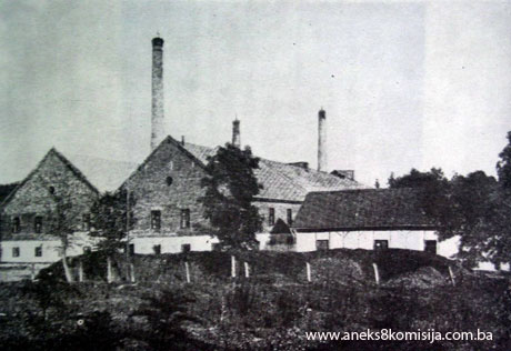
gradually decommissioned. The decommissioning took until 1975. Between 1891 and
1952, 12 salt-kettles had been built and begun production in the Kreka salt
works, along with seven tall industrial chimneys. Following the decision to
decommission the old salt-kettles once the new plant began production, all the
chimneys and production facilities, including the salt-kettles, were
demolished, with the exception of three salt-kettles and one chimney built in
1952, which were left as part of the Salt Museum of the Tuzla salt works, and
which are the subject of protection under the terms of this Decision.
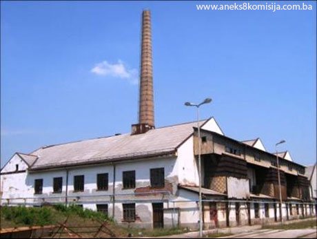
2. Description of the property
OLD KREKA SALT WORKS AND RARE
MATERIALS WAREHOUSE
The old
Kreka salt works and its plant were built in the 1950s.
The
building with salt-kettles 10, 11 and 12 (marked on the site plan of the salt
works as no. 14) measures 33.50 x 54.60 m, as does the rare materials warehouse
(marked on the site plan of the salt works as no. 6), and both are of the same
height with identical façades.
The
building with salt-kettles 10, 11 and 12 has a single wooden roof consisting,
in fact, of three interlinked gabled roofs with their ridges running crosswise
to the building (north-south), forming two gullies also running north-south
where their roof panes meet. Given the wide span of approx. 18 m, the roof
trusses of each of these three gabled roofs, which joined to form a single roof
over the entire production shed, consist of a combination of double sloped
studs, fixed on both sides by 2 x 12/16 cm ties level with the topmost 18 x 18
cm purlins and 2 x 16/20 cm ties on both sides level with the middle 18 x 18 cm
purlins, while each roof truss is reinforced by three steel tie beams. The
rafters are 12 x 15 cm in section and the struts are stouter, at 22 x 25 cm.
The roof cladding is asbestos tiles. The roof ridge is at a height of 14.10 m
above ground level.
The roof
trusses of the production shed rest on the bearing perimeter walls of the
building and a system of transverse (north-south) reinforced concrete beams and
bearers. The structural system of the building consists of a combination of
massive perimeter walls and reinforced concrete pillars and transverse bearers
with a horizontal reinforced concrete slab to add rigidity to the entire
structure. There are two rows of transverse pillars, set 18 metres apart,
between the outer bearing walls of building no. 14, which are approx. 51 cm
thick and built of solid brick. The ground-floor pillars measure approx. 40 x
60 cm in section, while those on the first floor are circular in section, with
a diameter of approx. 30 cm; the pillars themselves are approx. 4.00 m apart on
the first floor and 4 and 8 metres apart on the ground floor. The load-bearing
interstorey structure is a reinforced concrete slab approx. 20 cm thick at a
height of 4.00 m about floor level.
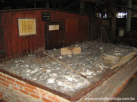
The three
salt-kettles, each with a footprint of approx. 8.75 x 20.60 m, are set approx.
9.20 m apart. To reduce heat loss and achieve the highest possible temperatures
when heating the brine in the salt-kettles, a separate gabled roof was erected
above each salt-kettle. This consists of 10 x 12 cm wooden rafters set on 14 x
16 cm purlins, with one-inch boards nailed to the rafters, with a slight pitch
of 10 degrees and the ridge about 1.35 m above the top of the salt-kettle. The
sides were closed off by wooden shutters made of one-inch boards. A grid of
wooden girders set on posts set about 4 m apart (structurally speaking, a
wooden frame) was mounted above each kettle, to which the roof structure was
attached by wire cables. The posts holding up the grid bearers stood on a
concrete slab, and were joined by wooden beams running north-south, parallel to
the longer side of the salt-kettle over which the structure was mounted, to add
rigidity to the frame as well as providing anchorage for the wire cables.
Fireproof
bricks were used to make three furnaces under each of the salt-kettles. The
walls were massive, at 85 cm thick, and the firebox had very deep foundations,
at 3.40 m below ground floor level. A system of pipes and ducts of various
rectangular cross-sections served to circulate the hot air that heated the
salt-kettles; the hot air evacuation system consisted of separate vertical
ducts joined to the roofs of the salt-kettles (each of which had one vertical
duct with an average cross-section of approx. 2.50 x 2.50 m, with the top of
the outlet duct at a height of 16.10 m). The salt-kettles and the masonry
structures of the fireboxes and furnaces were free-standing structures, with
their own separate foundations. To accommodate the centrifuge, conveyor belt
and rotary dryer, an area of approx. 8.15 x 44.15 m by the north wall was left
clear, without the interstorey reinforced concrete slab, thus providing the
two-storey height required. Two staircases around this air well led from the
ground to the first floor. On the outside, a platform with a pent roof was
built by the south wall, used to load salt into the wagons, which was
transported along a separate branch of the railway line that ran into the salt
works complex.
The
technical process of salt production at this time was as follows: brine from
the springs (Borić, Hukalo, Trnovac) was fed by pipeline into the salt works
precinct. The raw, unpurified brine was fed into wooden tanks and then piped
into the salt-kettles to a height of 45 cm. Here the coal-fired furnaces heated
the brine until the salt crystallized out. This caused the salt to form a mushy
deposit at the bottom of the furnace. This saline mush was extracted by čaklja
into a trough or grabuljar(47) and thence to be strained. This removed much of the water, and the
strained salt was then transported by trolley and overhead wagons to the
centrifuge where the water was mechanically removed from the salt. This reduced
the moisture content in the salt from 7% to 2%. The centrifuged salt was then
conveyed further in a rubber bucket elevator to the rotary drier(48). This operated on the principle
of injecting air and salt into the chamber to further dry the salt, which was
then packed.
The plant
in the old Kreka salt works was decommissioned in 1975. All the plant has been
retained in the 1952 production shed and is open to the public. In the 1980s
the Tuzla salt works designated this as a Salt Museum.
The
following can be seen in the surviving production shed:
-
on the first floor:
-
the pipes that fed brine
into the salt-kettles
-
salt-kettle no. 10 with
trough for the removal of saline mush
-
salt-kettle no. 11 with
trough for the removal of saline mush
-
salt-kettle no. 12 with
trough for the removal of saline mush
-
čakljas, chests for
soaking the čakljas, trolleys, overhead wagons, device for flattening the sheet
metal on which the salt-kettles were mounted
-
strainer plant
-
on the ground floor:
-
furnace and firebox for
salt-kettle no. 10
-
furnace and firebox for
salt-kettle no. 11
-
furnace and firebox for
salt-kettle no. 12
-
centrifuge where
mechanical action reduced the moisture content of the salt from 7% to 2%
-
conveyor belt
-
rotary drier
The
salt-kettles in which the brine was heated were constructed on the first floor
of the production shed, and measure approx. 8.75 x 20.60 m. Below each of these
is a coal-fired furnace. Access to the fireboxes is not currently possible on
account of the destroyed driers on the ground floor. The base of the
salt-kettles, to a height of 50 cm, is brick-built, with the inside in which
the brine is heated lined with metal plates riveted together(49). Above the masonry section of
the salt-kettles is a wooden structure with a maximum height of 180 cm. The
salt-kettles are covered by a low-pitched gabled roof. The salt-kettles are
entered through a door in the masonry section. Above the salt-kettles are the
pipes used to convey the brine, which run through the roof into the base of the
salt-kettles. To one side of each salt-kettle is a grabuljar – a narrow wooden
trough with a slight fall, running the full length of the bottom of the
salt-kettle. The saline mush was transferred to this trough and then taken to
be mechanically strained on a square platform in the middle of the first floor
of the production shed. All the tools used while heating the water and
transporting the saline mush to the drier on the ground floor were made of
wood; metal would have corroded in contact with the brine. After use these
wooden tools were placed in a trough of sweet water to be cleaned. A metal
funnel ran from the platform on which the saline mush was mechanically strained
down to the ground floor for further drying.
The first
step in drying the saline mush was to convey it to the centrifuge, where the
moisture was mechanically removed from the salt, so reducing the moisture
content from 7% to 2”. A certain quantity of saline mush would be tipped into
the centrifuge, which was powered by electricity; the rotation of the drum
containing the mush separated the moisture from the salt.
The
centrifuge and the rotary drier were linked by a conveyor belt – a rubber
bucket elevator. The salt was tipped into the rotary drier on one side, and air
entered it from the other through a fan. The salt dried out in the long
cylindrical rotary drier, the moisture was removed through a ventilation duct,
and at the end of the process the salt was ready to be hand-packed.
CHIMNEY
One
chimney survives, between the building housing the Salt Museum
and the rare materials warehouse. The chimney is built of solid brick, and is
approx. 39 m high from ground level to the outlet pipe; it is about 2.80 m in
exterior diameter at the top and the chimneypot is 75 cm high. The footings of
the chimney are 5.70 m below ground level, and the footings of the square base
are approx. 11 m long. The foundations widen stepwise from bottom to top by
1.30 m, 1.90 m, 1.30 m and 1.30 m.
WORKSHOPS
The two
single-storey buildings with a footprint of about 9.30 x 33 m to the east of
the rare materials warehouse are marked on the Solana site plan as nos. 18 and
19. Building no. 18 housed the joiners’ and blacksmiths’ workshops, and
building no. 19 the carpenters’ and bricklayers’ workshops. The buildings are
of solid brick, with a construction system consisting of longitudinal bearing
walls and transverse reinforcing walls. The buildings have gabled roofs with a
pitch of about 30 degrees, with wooden roof trusses; building no. 18 is clad
with grooved tiles and no. 19 with asbestos board. The outside walls have
single-light windows with overlights, measuring approx. 100 x 100 + 50 cm, over
which are wooden beams as lintels.
Inside
building no. 19, the carpenters’ workshop has retained its original flooring of
wooden blocks approx. 10 x 10 x 10 cm; the other workshops have rammed concrete
floors. The workshops are plastered on the inside; the outside walls were not
rendered, but simply given a lime milk finish.
The
workshops were built in the 1950s.
SALT MUSEUM
In 1975
the design studio Razvoj-projekt of Tešanj, Tuzla studio, drew up a project to
convert the two-storey building, measuring approx. 13.10 x 76.95 m +
13.30/11.25 x 17.95 m (a warehouse, T-shaped in plan, marked on the site plan
of the salt works as no. 5), which until 1975 contained a warehouse for
finished salt and packaging, into a Salt Museum with the necessary ancillary
facilities. The building consisted of a combination of massive longitudinal
bearing walls and a system of reinforced concrete pillars set 450 x 420 cm
apart (lengthwise/crosswise), reinforced concrete girders 30 x 30 cm in
section, and a reinforced concrete slab approx. 20 cm thick. The entrance to
the building is in the middle of the ground floor of the former warehouse, and
leads via a staircase in the south wing to the first floor. This wing also
contains the toilet block and a number of offices. The western part of the
first floor contains the Salt Museum's exhibition gallery, with an area of
approx. 473 m2, and the eastern part contains a small lecture hall (area
approx. 80 m2) and a larger lecture hall (area approx. 130m2) with ancillary
premises. In the museum premises, the ceilings are of perforated gypsum board
tiles, the floors consist of PVC flooring over a screed base, the walls and
reinforced concrete pillars are faced with 9 mm thick gypsum tiles and 18 mm
veneered woodchip board set into moulded oak frames, and new window frames with
matt glass have been added to all the windows in the museum premises, level
with the inside face of the surrounding walls. The former warehouse, now the
museum, is connected to the building with salt-kettles 10, 11 and 12 (marked
no. 14 on the site plan of the salt works) and with the building with the rare
materials warehouse (marked 6 on the site plan of the salt works).
In 1985,
on the occasion of the centenary of the opening of the modern salt works in Tuzla, the Museum
of Eastern Bosnia, in association with
the Solana salt works in Tuzla created a
permanent exhibition for the Salt Museum, on display in one of the Solana buildings in Tuzla and physically
connected with the surviving 1952 production shed. The display is entitled Salt
Production in Tuzla
from Prehistoric Times to the Present Day, and is designed to present the
methods of salt production used from Neolithic times to the opening of the exhibition.
The display thus contains:
-
a replica of pottery
vessels presumed to be used in Neolithic times for evaporating salt
-
iron pans used in
mediaeval and Ottoman times for evaporating salt
-
a reconstruction of a salt
workshop of the Ottoman period, based on the drawing by Franz Poech published
in the monograph Minerals Industry in Bosnia and
Herzegovina published in Vienna in 1900
-
documentation and
photographs relating to the establishment of the salt works at Simin Han and
Kreka during the Austro-Hungarian period in Bosnia and Herzegovina
-
photographs of wells, salt
works and workers during the Austro-Hungarian period in Bosnia and Herzegovina,
-
various tools used in salt
production – mainly for repairing water and brine pipelines and salt-kettles
and for removing deposits from the metal plates lining the salt-kettles,
fire-fighting tools etc.
-
articles relating to the
work carried out by workers in the salt works – clothing and footwear, office
furnishings (desk and chair, cabinet, telephone and fax)
-
articles relating to the
technical processes (models of the production plants in the salt works and
models evoking modern salt production)
-
photographs recording the
activities of workers outside working hours between 1945 and 1985
-
various certificates and
cups in recognition of worker and production performance in the salt works.
The full
inventory of the articles on display in the Salt Museum,
with 311 inventory items, is an integral part of this Decision.
PUMPING STATION AT BORIĆ
The
pumping station was built about 170 m to the north of the Džindija mosque,
right beside Borić street.
It measures approx 9.70 x 22.40 m in plan, and was designed to house two saline
tanks, for which the layout is ideal – the structure of the building is merely
a protective jacket consisting of surrounding walls approx. 40 cm thick, built
of solid brick, and a gabled roof. The main entrance (carpentry dimensions 173
x265 cm) is in the middle of the south wall, while a side door in the west wall
leads to an outbuilding housing the electricity control panel to the west of
the pumping station building. There are two windows (1.95 x 1.30 with the sill
at a height of 1.35 m) in the south wall on each side of the door, fitted with
5 x 3 cm slats set 4-5 cm apart to allow for a constant air flow within the
pumping station.
Each of
the tanks is set on three concrete foundation strip-beams running
longitudinally. Each of these strips is approx.100 cm wide and 9.25 m long, and
are about 65 cm above ground level.
The tanks
themselves, with a capacity of approx. 2 x 91m3, and measuring 2 x 5.30 m wide,
9.55 m long and 4.75 m high, are composed of oak beams of an average 25 x 25 cm
section, laid horizontally one above the other on the long sides of the tanks
and vertically next to each other on the short sides. There is no doubt some
kind of carpentry joint between these beams (probably some kind of wooden
dowel). The brine in the tanks has no doubt had some kind of conservation
effect on the walls, which are impregnated with salts.
The tanks
are surrounded by oak beam rings set vertically: each has 9 rings set about 85
cm apart, each of which consists of four beams with an average cross-section of
25 x 25 cm. The uprights are joined by insertion into horizontal beams, and to
compensate for the strong lateral forces (the hydrostatic pressure of the water
in the tanks on the wooden walls), the joins between the vertical and the
horizontal beams are further reinforced by wooden wedges.
The tanks
rest on their foundations via a grill of oak beams with an average
cross-section of approx. 25 x 25 cm; two oak beams of the same section, about
9.25 m long, are set longitudinally along the edges of the concrete
foundations, about 50 cm apart.
The join
between the longitudinal beams of the foundation grill and the horizontal beams
of the rings of the tanks is effected by means of an overlap and notch – where
the beams intersect, they are cut into to a depth of approx. 5 cm.
In terms
of layout, the tanks are set in a row longitudinally, about 100 cm apart and
about 2.53 m from the south wall, 1.07 m from the north wall, 1.15 m from the
east wall and 2.10 m from the west wall. A number of polyethylene pipes enter
the building from the east (the feed from the wells), to the south a number of
pipes lead to the pumping machinery, and to the west are the outlet pipes that
convey brine from the reservoir and are joined to the underground brine
pipeline. North of the reservoir on the west side of the building is a
single-flight wooden staircase about 6.35 m long with 19 steps and a landing
about 60 cm long) leading to the tank, which has an inspection porthole at the
top of the tank wall through which the inside of the tank can be reached. South
of the tank on the east side of the building is another single-flight staircase
about 4.15 m long with 15 steps, leading to the tank.
The
wooden roof trusses consist of triple posts set approx. 3.20 m apart. The
uprights of the posts are reinforced on both sides by horizontal tie beams. The
wooden rafters are set approx. 80 cm apart at an angle of approx. 16 deg. The
roof cladding is asbestos tiles.
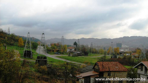
BRINE WELLS IN BORIĆ
The trial
drillings carried out on Trnovac hill in 1885 identified a high concentration
of brine of about 300 gr. NaCL/1l,3 as well as rich deposits of rock salt. As a
result, over a period of about 100 years a total of 176 brine wells were sunk
between Hukalo and Trnovac. Brine well no. 6, which marked the beginning of the
extraction of brine at Trnovac, remained in use for 30 years, and about 840m3
of brine was extracted from a depth of about 366 m, from which about 252,000
tonnes of salt was produced by evaporation in the salt works in Simin Han and
Kreka.
The
closure of the brine wells in May 2007 in the Hukalo – Bukovčić area, from
which brine was being extracted, eliminated the cause of subsidence in the town
of Tuzla. To
date, about 90 million cubic metres of brine have been extracted from this
stretch, producing 27 million tonnes of salt. The unchecked leaching of brine
has caused subsidence over an area of about 500 hectares, with the subsidence
averaging 10 metres, though some areas subsided to a depth of as much as three
times this.
Sinking
wells was carried out as follows: a borehole is first drilled, followed by
lining the borehole, reworking it as necessary to clear and widen it,
installing a pump (initially, underwater piston pumps with oscillator were
used, followed by piston pumps with flywheel; from 1965 on, vertical
centrifugal high-speed underwater pumps with a capacity of 300 l/min and a lift
height of up to 225 m were used, following which work began on erecting towers
above the wells).
At first
the above-ground towers of the brine wells were made of wood. These towers,
with gabled roofs, had a wooden grid structure and were shaped like a rounded
four-sided pyramid, with a footprint of approx. 5.10 to 6.50 x 5.10 to 6.50 m,
and measuring 2 x 2 m at the top. The grid structure had six horizontal tiers
linked by diagonals. Structurally, the tiers and diagonals acted as the struts
of the grid structure. The wooden beams of the grid varied in size depending on
the height of the tower; for instance, for a tower with sides of 6.50 m at the
base, the beams used for the lower grill would be 32 x 32 cm, the horizontal
beams would be 20 x 32 cm, the diagonal struts would be 12 x 20 cm, and so on. A
replica has been made of one of the wooden towers, and is now within the
Pannonian lake complex in Tuzla.
A pulley
wheel with a diameter of 560 mm mounted on two 20 x 20 beams set about 20 cm
apart would be fixed to the top of the tower, for lowering wire cables to
service and maintain the borehole and operate the derricks. The frame of the
wooden towers was faced with one-inch boards forming a jacket.
Later,
the timber grid structure was replaced by steel. The towers were again shaped
like a rounded pyramid, square in plan, with the sides measuring approx. 4640
mm at the base and 650 mm at the top, from axis to axis of the steel tubes. A
girder frame (14 in all, measuring 800 x 800 m) was mounted at the top of the
Ø73 mm steel tubes. Two parallel NPI 14 girders were laid on this frame to act
as the primary supports for the pulley. The steel tubes forming the frame of
the tower were 13200 mm long, and the height of the tower, measured vertically
from the base, was 12896 mm. This was composed of six sections with horizontal
and diagonal struts, except for the topmost section, which had none. The struts
were of L-profile 60 x 60 x 6 mm steel, and were joined at the nodes to steel
plates 15 mm thick. The basic axes through the centre of gravity of the struts
do not intersect at the same point.
When
lining the underground sections of the boreholes forming the brine wells,
different tubular profiles were used. In the case of borehole no. Tr-160, which
is still in use, a protective column of 530 mm profile was used from 0.00 to
20.00 depth; from 0.00 to 209.15 m depth an upper extraction column of 12 ¾
Zolla profile was used; from 0.43 to 256.10 m, an extraction column of 9 and
5/8 Zolla was used; from 220.30 to 260.24 m a lower extraction column of 7 and
5/8 Zolla profile was used; and from a depth of 260.24 to 371.88 m, a lower
extraction column of 5 ½ Zolla was used.
The brine
wells to be protected under the terms of this Decision were built in the late
19th and 20th centuries.
OTTOMAN PERIOD BRINE WELL
On
arrival in 1474, the Ottomans built the first brine wells used for the
extraction of brine. The surviving brine well of that period is in Salt Square, which
was named after the salt production there.
The well
is about 60 metres deep and was used to extract brine which was then heated in
iron pans over fire. The entire process of obtaining salt from brine is
described in the text of this Decision in the section headed Historical
Information.
The brine
was kept in low, wide barrels with a capacity of 50-60 l. The brine was
extracted from the well under the oversight of an imperial official, using a
scoop known as a čabra which had two apertures in its staves through
which a pole would be inserted to make it easier for two workers to carry. The
people of Tuzla
also called this scoop a vadača. Each brine well usually had six of these, each
with a capacity of 50 l. Buckets were used to pour the brine into the pan, and
a salt scoop was used to add brine during heating. After the water had
evaporated off, the salt was poured into a sack using a small spoon, and a
scraper was used to scrape the salt off the pan.
This
method of obtaining salt was used until the annexation of Bosnia and Herzegovina
by the Austro-Hungarian monarchy. After opening the salt works at Simin Han and
Kreka and the brine wells at Trnovac and Hukalo, the Austro-Hungarians filled
in the old Ottoman well.
The well
was dug out again in 2003 when Salt
Square was built.
The well
has been partly conserved and restored, and a wooden facing and glazed roof
have been installed.
The well
is now an integral part of Salt
Square, where visitors can learn about the traditional
method of extracting and obtaining salt from Neolithic times to the Ottoman
period.
While
this square was being laid out, a modern exhibition space was built – a
stylized lake dwelling with a museum display showing the methods of producing
salt in the Neolithic and Ottoman period.
Also
forming part of this ensemble is a fountain, donated by the town of Ravenna, the work of
Felice Nittoli. It is composed of mosaic, and evokes the flags of the two
towns, Tuzla and Ravenna, with a dove as the symbol of peace. The
mosaic is also decorated by a replica of a Neolithic vessel at the base of the
fountain.
Alongside
the Ottoman-period brine well, exhibition space and fountain, there is also a
flagpole with the flag of the town of Soli
in Salt Square.
3. Legal status to date
The old
Kreka salt works in Tuzla
has not been subject to protection by the Institute for the Protection of the
Cultural, Historical and Natural Heritage.
The
Regional Plan for Tuzla Municipality for 1986/2000/2006 does not provide for either
the old Kreka salt works or the Museum in the Tuzla salt works to enjoy protected status.
4. Research and conservation and
restoration works
There is
no information available on conservation and restoration works on the
facilities of the old Kreka salt works, chimney, workshops or rare materials
warehouse, or on the Salt
Museum building.
Nor is
any information available on conservation and restoration works on the pumping
station and brine wells on Borič hill.
The
Ottoman-period brine well was excavated in 2003. The archaeological
works were conducted under the supervision of the Museum
of Eastern Bosnia in Tuzla
by archaeologist Adnan Muftarević, a member of staff of the Museum of Sarajevo.
5. Current condition of the
property
The roof
cladding of the facilities of the old Kreka salt works (building no. 14) and
the pumping station is damaged as a result of lack of maintenance and war
damage.
A
structural crack can be seen at the south-west corner of the pumping station.
The crack is about 2-3 cm wide and runs from the corner of the horizontal ring
beam below the roof cornice to the foundations.
The brine
wells are in good condition.
The
Ottoman-period brine well is in good condition
MOVABLE HERITAGE
The old
Kreka salt works – production shed.
All the
surviving plant is in very poor condition. The salt-kettles in which the brine
was boiled off are damaged by lack of maintenance (parts of the planks forming
a canopy over the salt-kettles are missing, the sheet metal covering the base
of the salt-kettles is missing, and there is damage in places to the masonry
section of the base of the salt-kettles). The centrifuge is inoperable and
damaged by corrosion. The rubber bucket elevator between the centrifuge and the
rotary drier is broken and unusable. The rotary drier is also inoperable
because of rust. The pipes feeding air to the machine are broken and have
become detached.
The walls
of the furnaces have collapsed in places.
The
electric wiring has been destroyed and there is no power in the production shed.
Salt Museum – exhibition premises
The items
on display in the permanent exhibition of Salt Mining in Tuzla from Prehistoric Times to the Present
are in good condition.
6. Specific risks
Subsidence
caused by the uncontrolled exploitation of brine could result in widening of
the cracks on the pumping station on Borić hill.
III – CONCLUSION
Applying
the Criteria for the adoption of a decision on proclaiming an item of property
a national monument (Official Gazette of BiH nos. 33/02 and 15/03), the Commission
has enacted the Decision cited above.
The
Decision was based on the following criteria:
A. Time frame
B. Historical value
C. Artistic and aesthetic value
C.i. quality of workmanship
C.ii. quality of materials
C.iii. proportions
C.iv. composition
C.v. value of details
C.vi. value of construction
D. Clarity
(documentary, scientific and educational value)
D.i. material evidence of a lesser known
historical era
D.ii. evidence of historical change
D.iv. evidence of a particular type, style or regional
manner
D.v. evidence of a typical way of life at a
specific period
E. Symbolic value
E.iii. traditional value
E.v. significance for the identity of a group of
people
F. Townscape/ Landscape value
F.i. relation to other elements of the site
F.ii. meaning in the townscape
F.iii. the building or group of buildings is part
of a group or site
G. Authenticity
G.i. form and design
G.ii. material and content
G.iii. use and function
G.iv. traditions and techniques
G.v. location and setting
G.vii. other internal and external factors
H. Rarity and representativity
H.i. unique or rare example of a certain type
or style
I. Completeness
I.i. physical coherence
I.ii. homogeneity
I.iii. completeness
I.iv. undamaged condition
The
following documents form an integral part of this Decision:
-
Copy of cadastral plan
-
Copy of land register
entry and proof of title
-
Photodocumentation
-
Drawings
Bibliography
During
the procedure to designate the industrial heritage of salt production in Tuzla, Municipality Tuzla, as a national monument of Bosnia
and Herzegovina the following works were
consulted:
1930. Jokanović, Branko. “Nalazišta soli u okolici Donje i Gornje
Tuzle” (Salt Deposits in the Environs of Donja and Gornja Tuzla), Rudarsko-topionički
vijesnik (Mining and Foundry News), yr. II, no. 1. Belgrade: 1930, 14-19
1975. Basler, Đuro. Župa i grad
Soli u Srednjem vijeku. Devedeset godina industrijske proizvodnje
soli u Tuzli (The County and Town of Soli
in Mediaeval Times. Ninety years of industrial salt production in Tuzla). Tuzla: 1975, 9-17
1975. Handžić, A. Tuzlanske solane od XV do XVII stoljeća. Devedeset
godina industrijske proizvodnje soli u Tuzli. (The Tuzla salt factories from the 15th to the
17th century. Ninety years of industrial salt production in Tuzla). Tuzla:
1975, 17-19
1978. Ilić, Žarko, Salih Kulenović. “Tradicionalni načini i sprave za
proizvodnju soli u Tuzli” (Traditional methods and equipment for the production
of salt in Tuzla),
special offprint Članci i građa za kulturnu istoriju istočne Bosne (Articles
and Material for the Cultural History of Eastern Bosnia) XII. Tuzla:
Museum of Eastern Bosnia, 1978.
1985. Milić, Veljko, Salih Kulenović, Nikola Panjević et.al. Solarstvo
u Tuzli od praistorije do danas (Salt production in Tuzla from prehistoric times to the present
day). Tuzla:
1985.
1990. Buljugić, Suad. Tuzlanske solane i solari (Tuzla's salt factories and
salt workers). Tuzla:
1990.
2002. Hidanović Solanjanin, Fahrudin. Župa soli Gradovrh (The
County of soli Gradovrh). Tuzla:
2002.
Documentation
from the archives of the Solane d.d. Tuzla
salt works
Documentation
from the archives of the Tušanj salt mine
(1) From the map
provided - copy of cadastral plan, and title deed no. 3242 c.m. Tuzla I Department of Geodetic and
Proprietary Rights Affairs, Municipality Tuzla.
(2) From the
map provided - copy of cadastral plan, and title deed no. 3242 c.m. Tuzla I
Department of Geodetic and Proprietary Rights Affairs, Municipality Tuzla.
(3) From the
map provided - copy of cadastral plan, and title deed no. 3242 c.m. Tuzla I
Department of Geodetic and Proprietary Rights Affairs, Municipality Tuzla.
(4) From the
map provided - copy of cadastral plan, and title deed no. 4470 c.m. Tuzla I
Department of Geodetic and Proprietary Rights Affairs, Municipality Tuzla.
(5) From the
map provided - copy of cadastral plan, and title deed no. 4470 c.m. Tuzla I
Department of Geodetic and Proprietary Rights Affairs, Municipality Tuzla.
(6) From the
map provided - copy of cadastral plan, and title deed no. 3242 c.m. Tuzla I
Department of Geodetic and Proprietary Rights Affairs, Municipality Tuzla.
(7) From the
map provided - copy of cadastral plan, and title deed no. 179 c.m. Tuzla II
Department of Geodetic and Proprietary Rights Affairs, Municipality Tuzla.
(8) From the
map provided - copy of cadastral plan, and title deed no. 335 c.m. Tuzla II
Department of Geodetic and Proprietary Rights Affairs, Municipality Tuzla.
(9) From the
map provided - copy of cadastral plan, and title deed no. 1565 c.m. Tuzla II
Department of Geodetic and Proprietary Rights Affairs, Municipality Tuzla.
(10) From the map
provided - copy of cadastral plan, and title deed no. 505 c.m. Tuzla II
Department of Geodetic and Proprietary Rights Affairs, Municipality Tuzla.
(11) From the
map provided - copy of cadastral plan, and title deed no. 3 c.m. Tuzla II
Department of Geodetic and Proprietary Rights Affairs, Municipality Tuzla.
(12) From the
map provided - copy of cadastral plan, and title deed no. 505 c.m. Tuzla II
Department of Geodetic and Proprietary Rights Affairs, Municipality Tuzla.
(13) From the
map provided - copy of cadastral plan, and title deed no. 340 c.m. Tuzla II
Department of Geodetic and Proprietary Rights Affairs, Municipality Tuzla.
(14) From the
map provided - copy of cadastral plan, and title deed no. 340 c.m. Tuzla II
Department of Geodetic and Proprietary Rights Affairs, Municipality Tuzla.
(15) From the
map provided - copy of cadastral plan, and title deed no. 491 c.m. Tuzla II
Department of Geodetic and Proprietary Rights Affairs, Municipality Tuzla.
(16) From the
map provided - copy of cadastral plan, and title deed no. 1235 c.m. Tuzla II
Department of Geodetic and Proprietary Rights Affairs, Municipality Tuzla.
(17) From the
map provided - copy of cadastral plan, and title deed no. 1235 c.m. Tuzla II
Department of Geodetic and Proprietary Rights Affairs, Municipality Tuzla.
(18) From the
map provided - copy of cadastral plan, and title deed no. 1235 c.m. Tuzla II
Department of Geodetic and Proprietary Rights Affairs, Municipality Tuzla.
(19) From the
map provided - copy of cadastral plan, and title deed no. 340 c.m. Tuzla II
Department of Geodetic and Proprietary Rights Affairs, Municipality Tuzla.
(20) From the
map provided - copy of cadastral plan, and title deed no. 1681 c.m. Tuzla II
Department of Geodetic and Proprietary Rights Affairs, Municipality Tuzla.
(21) From the
map provided - copy of cadastral plan, and title deed no. 54 c.m. Tuzla II
Department of Geodetic and Proprietary Rights Affairs, Municipality Tuzla.
(22) From the
map provided - copy of cadastral plan, and title deed no. 340 c.m. Tuzla II,
Department of Geodetic and Proprietary Rights Affairs, Municipality Tuzla.
(23) From the
map provided - copy of cadastral plan, and title deed no. 724 c.m. Tuzla II
Department of Geodetic and Proprietary Rights Affairs, Municipality Tuzla.
(24) From the
map provided - copy of cadastral plan, and title deed no. 768 c.m. Tuzla II
Department of Geodetic and Proprietary Rights Affairs, Municipality Tuzla.
(25) From the
map provided - copy of cadastral plan, and title deed no. 898 c.m. Tuzla II
Department of Geodetic and Proprietary Rights Affairs, Municipality Tuzla.
(26) From the
map provided - copy of cadastral plan, and title deed no. 342 c.m. Tuzla II,
Department of Geodetic and Proprietary Rights Affairs, Municipality Tuzla.
(27) From the
map provided - copy of cadastral plan, and title deed no. 342 c.m. Tuzla II
Department of Geodetic and Proprietary Rights Affairs, Municipality Tuzla.
(28) The basin was
formed at the beginning of the Styrian orogenic zone, and consists of sediments
from the Eocene, Oligocene, Miocene, Pliocene and Pleistocene. The salt
deposits in Tuzla are composed of halite (NaCl), tenardite (Na2SO4) and five
series of salt from saline bodies separated by dolomitic, clay-marl sediments
known as banded series (documentation of the Tušanj salt mine)
(29) The shape
of the original vessel cannot be reconstructed with any certainty since too few
fragments have been found to make this possible. The existing sherds suggest
that they were sizeable pots with the opening generally between 80 and 100 cm
wide. Judging from the incurving rim, they must have been shallow vessels,
while the large quantity of feet of the same manufacture as the rims suggest
that they were large, shallow vessels with flat or pointed feet. It is
suggested that they were used to evaporate salt from brine (the brine was
probably poured into them and left to evaporate, leaving the salt in the bottom
of the pot). (Buljugić, 1990, 9)
(30) Salt in
Latin is sal, and a salina is a place where salt is found (Hidanović,
2002, 17)
(31) In
mediaeval times Bosnia and Herzegovina
had another two sites where salt was extracted, apart from Tuzla
– the salt works in Drijevi near Gabela and in Dračevica near Novi.
(Basler, 1975, 9)
(32) The actual
boundaries of the county of Soli are not known, but Đuro Basler suggests that
they could have run east to Kalesija and Oskam, west to Lukavac, north to the peak of Mt Majevica, and south to Banovići and
Đurđevik. (Basler, 1975, 9)
(33) A
Franciscan monastery was built here in the 16th century for Franciscans from
Zvornik.
(34) The
mediaeval Grad (= town or fort) was to the east of the present-day quarter of
Varoš, atop the steep hill now called Grad. The mediaeval fort was surrounded
by a tall timber stockade. Below it were the outskirts, in a place called
Varoš. There are two places nearby called Crkvina [suggesting the presence at
one time of a church].
(35) The
Ottomans had various names for modern Tuzla:
the Turkish Agac Tuzla (wooden salt works, salt works with wood-fired
production), the Arabic-Persian constructs Memleha-i cob and Memleha-i
diraht (wooden salt works) by way of explaining how salt was produced from
brine. (Handžić, 1975, 18)
(36) “Of the
income from six days in the week paid out in cash, the net income from three
days shall be paid to the imperial treasury, and as to the income from the
[remaining] three days, the other half, the workers themselves may have it. The
wood needed to produce salt for the four days belonging to the imperial
treasury shall be purchased by the emini and mubaširi as required, and what is
left after that the workers may take. When the salt has been produced, first to
be sold shall be the state salt, after which the workers may sell theirs...” (Handžić,
1975, 22)
(37) This
method of producing salt was possible because the brine in the Tuzla basin has a maximum salt concentration
of 24-25% NaCl, so that 100 l of brine yields an average of about 32 kg of
salt.
(38) Adem
Handžić refers to the existence of so-called čob salt works, referred to
in Ottoman documents from 1620 to 1646 and in 1750 in connection with the
exploitation of brine. Handžić explains that the Turkish word čob means
wood, withy or switch, and therefore suggests that this is related to the use
of sieves made of withies to obtain salt. (Ilić, Kulenović, 1978, 42)
(39) This
indicates that there were about 150 open wells in Gornja and Donja Tuzla and
that time from which brine was drawn, and that salt was obtained solely by
boiling the water off in salt-kettles or pans.
(40) The salt works were named Franz Jozef Saline.
(41) Čaklja
– simple wooden tool consisting of two parts, a long wooden handle (1 to 7 m
long) with a board, about 50 x 20 cm, fixed to it at right angles, used to convey
the saline mush from the pan to the wooden chests.
(42) Coal was
transported on the industrial railway track in small horse-drawn iron wagons
known as “huntići.” In the late 1920s a steam engine was introduced and horses
were no longer used to pull the coal wagons.
(43) Other coal
consumers emerged after the Simin Han salt works: the industrial spirit factory
in Tuzla, the Bavarian and Hungarian steel
works, the penitentiary in Zenica and, in smaller quantities, the towns of Osijek, Bijeljina, Županja
and Slavonski Brod (Buljugić, 1990, 38)
(44) Block salt
for human consumption was pure, white and dry. Each block weighed 5 kg. Poorer
quality salt was used to make salt licks for animal consumption, such as the
salt from the dripping room, the initial quantities of salt produced when a new
salt-kettle began production, crushed salt slabs and so on. To ensure that it
would not be used for human consumption, it was invariably coloured with finely
ground coal, iron trioxide or other non-harmful substances.
(45) During
World War II, the impact of the war, reduced demand and obsolete technology
meant that the production of block salt for both human and animal consumption
ceased altogether in the salt works. The blocking equipment was dismantled in
1954 and the building was converted into a machine shop. (Buljugić, 1990, 56)
(46) The reason for
this was the occurrence of goitre in the Banja
Luka, Vlasenica and Srebrenica areas and in Kosovo. In
1935, salt began to be packed in cardboard boxes, and salt packed in this way
was invariably iodized.
(47) Grabuljar
– a narrow trough with a slight fall running the full length of the
salt-kettle.
(48) The rotary
drier in the Salt
Museum was in use from
1961 to 1976.
(49) Since the
water fed into the salt-kettles was unpurified, during heating all the waste
matter such as sulphur and other substances fell to the bottom of the
salt-kettle and stuck to the metal plates lining the salt-kettle. This would
build up in time to the point that it would have an adverse impact on the heating
process. The salt workers would then go into the salt-kettle and strip off
these deposits using hammers and chisels.
The fire was not put out in the furnace below while this was being done,
but was merely damped down. The metal
plates were replaced as needed and riveted to those already in place in the
same way. To protect their feet, the workers would enter the salt-kettle
wearing wooden clogs, which were resistant to high temperatures. (information
from the Salt Museum, engineer Fadil Kurto)