Status of monument -> National monument
Published in the „Official Gazette of BiH“ no. 29/08
Pursuant to Article V para. 4 Annex 8 of the General Framework Agreement for Peace in Bosnia and Herzegovina and Article 39 para. 1 of the Rules of Procedure of the Commission to Preserve National Monuments, at a session held from 11 to 17 September 2007 the Commission adopted a
D E C I S I O N
I
The archaeological site of Lištani-Podvornice, Livno Municipality, is hereby designated as a National Monument of Bosnia and Herzegovina (hereinafter: the National Monument).
The National Monument consists of an archaeological site with the remains of a late antique tomb, early Christian churches (north and south) and mediaeval necropolis, together with movable heritage found on the archaeological site and housed in the Gorica Franciscan monastery and gallery in Livno, as listed in the inventory books of the museum.
The National Monument is located on a site designated as cadastral plot no. (part) 433, Land Register entry no. 89, title deed no. 31, c.p. no. (part) 433, Land Register entry no. 89, title deed no. 30, c.p. no. (part) 433, Land Register entry no. 89, title deed no. 858, c.p. no. 434/5, Land Register entry no. 339, title deed no. 225, c.p. no. 442/1, Land Register entry no. 93, title deed no. 200, c.p. no. 441, Land Register entry no. 95, title deed no. 239, c.p. (part) 434/4, Land Register entry no. 339, title deed no. 244, cadastral municipality Odžak, Livno Municipality, Federation of Bosnia and Herzegovina, Bosnia and Herzegovina.
The provisions relating to protection measures set forth by the Law on the Implementation of the Decisions of the Commission to Preserve National Monuments, established pursuant to Annex 8 of the General Framework Agreement for Peace in Bosnia and Herzegovina (Official Gazette of the Federation of BiH nos. 2/02, 27/02 and 6/04) shall apply to the National Monument.
II
The Government of the Federation of Bosnia and Herzegovina (hereinafter: the Government of the Federation) shall be responsible for ensuring and providing the legal, scientific, technical, administrative and financial measures necessary to protect, conserve, display the National Monument.
The Commission to Preserve National Monuments (hereinafter: the Commission) shall determine the technical requirements and secure the funds for preparing and setting up signboards with the basic data on the monument and the Decision to proclaim the property a National Monument.
III
To ensure the on-going protection of the National Monument on the area defined in Clause 1 para. 3 of this Decision, the following measures are hereby stipulated:
- all works are prohibited other than research and conservation and restoration works, including those designed to display the monument, with the approval of the Federal Ministry responsible for regional planning and under the expert supervision of the heritage protection authority of the Federation of Bosnia and Herzegovina,
- the dumping of waste is prohibited,
- the site of the National Monument shall be cleared, shall be open and accessible to the public, and may be used for educational and cultural purposes.
The buffer zone, which covers a radius of 20 m from the boundaries of the research area of the site, is a site of potential archaeological value. In this zone, deep ploughing is prohibited, as are building works that could in any way have the effect of altering the site, unless such works are designed to protect and present the National Monument.
Investigative archaeological works must be carried out prior to any road reconstruction or maintenance work.
IV
The removal of the movable heritage items referred to in Clause 1 para. 3 of this Decision (hereinafter: the movable heritage) from Bosnia and Herzegovina is prohibited.
By way of exception to the provisions of paragraph 1 of this Clause, the temporary removal from Bosnia and Herzegovina of the movable heritage for the purposes of display or conservation shall be permitted if it is established that conservation works cannot be carried out in Bosnia and Herzegovina.
Permission for temporary removal under the conditions stipulated in the preceding paragraph shall be issued by the Commission to Preserve National Monuments, if it is determined beyond doubt that it will not jeopardize the movable heritage in any way.
In granting permission for the temporary removal of the movable heritage, the Commission shall stipulate all the conditions under which the removal from Bosnia and Herzegovina may take place, the date by which the items shall be returned to the country, and the responsibility of individual authorities and institutions for ensuring that these conditions are met, and shall notify the Government of the Federation of Bosnia and Herzegovina, the relevant security service, the customs authority of Bosnia and Herzegovina, and the general public accordingly.
V
All executive and area development planning acts not in accordance with the provisions of this Decision are hereby revoked.
VI
Everyone, and in particular the competent authorities of the Federation of Bosnia and Herzegovina, the Canton, and urban and municipal authorities, shall refrain from any action that might damage the National Monument or jeopardize the preservation and rehabilitation thereof.
VII
The Government of the Federation, the Federal Ministry responsible for regional planning, the Federal Ministry reponsible for culture, the Federation heritage protection authority, and the Municipal Authorities in charge of urban planning and land registry affairs, shall be notified of this Decision in order to carry out the measures stipulated in Articles II to VI of this Decision, and the Authorized Municipal Court shall be notified for the purposes of registration in the Land Register.
VIII
The elucidation and accompanying documentation form an integral part of this Decision, which may be viewed by interested parties on the premises or by accessing the website of the Commission (http://www.aneks8komisija.com.ba)
IX
Pursuant to Art. V para 4 Annex 8 of the General Framework Agreement for Peace in Bosnia and Herzegovina, decisions of the Commission are final.
X
This Decision shall enter into force on the date of its adoption and shall be published in the Official Gazette of BiH.
This Decision has been adopted by the following members of the Commission: Zeynep Ahunbay, Amra Hadžimuhamedović, Dubravko Lovrenović, Ljiljana Ševo and Tina Wik.
No. 05.1-2-936/03-4
12 September 2007
Sarajevo
Chair of the Commission
Dubravko Lovrenović
E l u c i d a t i o n
I – INTRODUCTION
Pursuant to Article 2, paragraph 1 of the Law on the Implementation of the Decisions of the Commission to Preserve National Monuments, established pursuant to Annex 8 of the General Framework Agreement for Peace in Bosnia and Herzegovina, a “National Monument” is an item of public property proclaimed by the Commission to Preserve National Monuments to be a National Monument pursuant to Articles V and VI of Annex 8 of the General Framework Agreement for Peace in Bosnia and Herzegovina and property entered on the Provisional List of National Monuments of Bosnia and Herzegovina (Official Gazette of BiH no. 33/02) until the Commission reaches a final decision on its status, as to which there is no time limit and regardless of whether a petition for the property in question has been submitted or not.
On 14 January 2003 the Gorica Franciscan museum and gallery in Livno submitted a proposal/petition to designate the archaeological site of Lištani-Podvornice with remains from ancient Roman and early and late mediaeval times, Livno Municipality, as a national monument of Bosnia and Herzegovina.
Pursuant to the provisions of the law, the Commission proceeded to carry out the procedure for reaching a final decision to designate the Property as a National Monument, pursuant to Article V para. 4 of Annex 8 and Article 35 of the Rules of Procedure of the Commission to Preserve National Monuments.
II – PROCEDURE PRIOR TO DECISION
In the procedure preceding the adoption of a final decision to proclaim the property a national monument, the following documentation was inspected:
- Documentation on the location and current owner and user of the property (copy of cadastral plan and copy of land register entry)
- Data on the current condition and use of the property, including a description and photographs, data of war damage, data on restoration or other works on the property, etc.
- Historical, architectural and other documentary material on the property, as set out in the bibliography forming part of this Decision.
The findings based on the review of the above documentation and the condition of the property are as follows:
1. Details of the property
Location
The Lištani–Podvornice site is in the Livno plain, the largest karst plain in south-western Bosnia(1).
The village of Lištani is in the south-western part of the Livno plain, 24 km from the town of Livno on the Grahovo road. According to local people, about forty years ago a macadam road ran below the site, but was then diverted because there was so much water there. The asphalt road laid in 1981 bisected and partly desrtroyed the Podvornice archaeological site, which is very close to a late mediaeval necropolis with stećak tombstones (beside the modern Catholic cemetery) and alongside the slopes of a prehistoric Iron Age hillfort, used as a fort in Roman times (M.Marić. 2005, 74).
The National Monument is located on a site designated as cadastral plot no. (part) 433, Land Register entry no. 89, title deed no. 31, c.p. no. (part) 433, Land Register entry no. 89, title deed no. 30, c.p. no. (part) 433, Land Register entry no. 89, title deed no. 858, c.p. no. 434/5, Land Register entry no. 339, title deed no. 225, c.p. no. 442/1, Land Register entry no. 93, title deed no. 200, c.p. no. 441, Land Register entry no. 95, title deed no. 239, c.p. (part) 434/4, Land Register entry no. 339, title deed no. 244, cadastral municipality Odžak, Livno Municipality, Federation of BiH, Bosnia and Herzegovina.
Historical information
Ever since ancient times the fertile Livno plain has favoured the development of agriculture and animal husbandry. It is surrounded by about forty Illyrian hillforts, all well defended and within the line of sight of other forts, which could be used as places of refuge in times of danger. In the early Bronze Age, they were more permanently settled (D. Periša, 1994, pp. 19,24).
Since the Late Copper and Early Bronze Ages, when the Cetina culture emerged in these parts, the Livno region has gravitated towards and had an unbroken connection with the nearby Delmatae (Dalmatian) area. (A. Milošević, 1999, p.7).
The Cetina culture had a considerable influence on the cultural development of the Illyrian tribes, and in its later stages, particularly in the early Iron Age, left its mark on the formation of the Delmatae community in this area.
The Livno and neighbouring plains of south-western Bosnia and Dalmatia formed the heartlands of the Delmatae, whence cultural and economic influences spread to parts of central Dalmatia. The Greek historian Polybius (c. 200-130 BCE) provided the first written record of the Delmatae, who gained strength in the first half of the 2nd century and attacked the people of Issa and the towns of Tragurion (Trogir) and Epetion (Stobreč), as well as threatening the neighbouring Daorsi, demanding tribute from them in grain and livestock (M. Zaninović, 1994, p. 46 ).
Following the revolt of the Delmatae under Baton (6-9 BCE), and their defeat, the process of Romanization began. The Livno plain had always been of great importance as a link between the interior and the Adriatic and Mediterranean hinterland. Roman roads are striking evidence of the process of Romanization.
The Roman waystation of Pelva (Lištani) on the road between Aequum (Čitluk near Sinj) and Salvium (Vrbo, the Glamoč plain) in Lištani and Bariduum, probably where the town of Livno now stands, was one of the links between these areas. The road leading from Lištani over a distance of 4 km to Strupnići below Golija was accompanied by minor local roads between the various settlements. The main Roman road across the Livno plain linked Salon and Servitium (Bosanska Gradiška).
While retaining their Delmatian names, as evidenced by inscriptions and epitaphs on tombstones, the population adopted the practice of incineration(2), using urns shaped like houses or temples, only to reintroduce inhumation(3) from the mid 2nd century on. There is extensive material evidence dating from the time of Roman domination, much of which is housed in the Gorica Franciscan Museum and Gallery in Livno.
The late antique period and the turbulent times of migrations by the Huns, Goths and other peoples, forced the inhabitants of the plain to seek refuge in hillforts such as Gradina at the source of the Bastašica, Grac in Potočani, Tabija and Podgradina, and Gradina in Grkovci.
Systematic investigations of the Lištani–Podvornice site have helped considerably in shedding light on the late antique period, since most of the sites known so far in the Livno area have yet to be studied (possible sites include Bastasi, Podgradina, Suhača, Donji Rujani and Lištani ), with the exception of the Podgradina-Rešetarica site and St John's in Livno.
In the 9th century, the county of Livno probably covered not only the Livno plain but also the Duvno and Glamoč plains. The country town was Livno, which is first referred to in 892 by the name of Cleuna, in a charter of the Croatian prince Muncimir, which cites Želimir, lord of the county of Livno, in the capacity of witness (M. Petrinec, 1999, p. 32). The name of the town also appears in a census of inhabited forts in the mid 10th century work by the Byzantine Emperor Constantine Porphyrogenitus, De Administrando Imperio, in which he describes Croatia and lists its counties, with Livno first on the list of eleven. Livno county probably covered the Duvno and Glamoč plains as well as the Livno plain. A charter of King Zvonimir dating from the last quarter of the 11th century refers to Dobrila, comes (count) of Livno.
Ecclesiastically speaking, in mediaeval times Livno was under the jurisdiction of the Split archbishopric, and its powers were confirmed by the Hungaro-Croatian kings Koloman (1103) and Andrija II (1207). Pope Celestine III also included the county of Livno within this bishopric. With the formation of the Bosnian vicariate in 1340, Livno formed part of the Duvno custodiate, which covered western Herzegovina, the Cetina region and Tropolje (Završje).
From the early 13th century, the area covering the Livno, Glamoč and Duvno plains was increasingly referred to as Tropolje (Tres campi). In 1326, during the reign of Stjepan II Kotromanić (1314-1353), Tropolje became part of the Bosnian state, after which it was known as Završje or the Western Marches, reflecting a central Bosnian point of view.
The Livno fort itself (castrum Cleune) was also known at times as the Bistrica fort (castrum Bystryze), since the mediaeval fort, of which the ramparts and towers are still visible, was above the source of the river Bistrica.
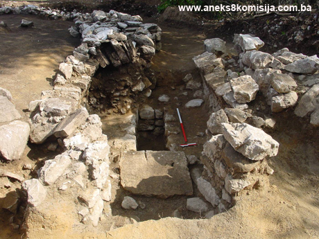
2. Description of the property
The location was originally known as the church of St. Rose, Lištani, Livno. It was investigated in 1981 by V. Atanacković-Salčić. While the asphalt road was being laid, the chance discovery was made of graves, the remains of a basilica, and a late-antique vaulted tomb. A fragment of an inscribed plaque was found by the entrance to the tomb, and two skeletons, their bones displaced, inside it. Shards of pottery vessels were also found. A child's grave was found to the south, with a La Tène-style fibula in it. Both graves were surrounded by a solidly-built wall (V. Atanacković-Salčić,1988, p.236)(4).
The site lies on both sides of the asphalt road. Scattered pieces of antique Roman stone sepulchral monuments were found on the part that was investigated, the northern half of the site. Fragments of a marble altar table, a vaulted tomb, and fragments of late-antique glass suggested the existence of an early Christian basilica: of particular note are fragments of the rounded rim, base and handle of a glass vessel. While clearing the vaulted tomb, fragments of Roman spolia were found, used as doorjambs, and to the right part of a relief monument, probably a stela, with the busts of a man and a woman, and to the right part of the cover of an urn.
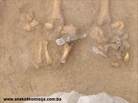
The southern half of the site contains graves at a depth of no more than 0.40 to 0.80 m. These graves are neatly arranged in rows. Eighteen of them were excavated. The burials were simple, direct in the ground or partly surrounded by undressed stone. The graves lie east-west. The skeletons were laid on their backs, their arms at their sides. Eight graves contained grave-goods, mainly jewellery of the Dalmatian-Croatian culture: standard silver or bronze open-ended hoops, hoops with one end bent into a hook and the other into a loop, single-beaded earrings with smooth beads, luxury single-beaded earrings made of filigree and granulation, and plain rings.
An important find was that of a pair of iron spurs found in situ in grave G-1, typologically dated roughly to the mid 10th to mid 11th century (M. Marić, 2003, p. 75 ).
In grave G-12 an iron communion spoon was found on the shoulderblades of the skeleton; this is a relatively rare item to find in a grave. The literature so far available suggests that this is the first such instance in a grave in an old Croatian necroppolis.
The osteological material was taken to the Osijek archaeological laboratory of the Croatian Academy of Arts and Sciences in Zagreb.
Following the important findings of the first investigations, a second campaign was conducted from 1 July to 22 August 2003. These continued on the system of a network of coordinates measuring 5 x 5 m that had already been set up.
Part of a foundation wall continuing eastwards from the previously uncovered foundations of the north wall of the early Christian basilica were found, as were the foundations of a small semicircular side apse with a basal foot and the founations of the small semicircular north apse. Since the asphalt road probably bisected the southern part of the basilica, one can only surmise that it was a basilica with side rooms, but it remains unclear whether it was a triapsidal basilica.
On the southern half of the site, where the necropolis was investigated, architectural foundations were discovered. The most valuable find was that of an early Christian cistern (baptismal pool) in a good state of preservation, oval in form with three uprights to the east and one surviving to the west. The interior was lined with hydraulic plaster, and fragments of glass vessels were found at the bottom, two of which have been reconstructed, the larger in the shape of a chalice and the other a lumin (hanging-lamp) with three handles. This is the first such cistern yet found in the Livno plain.
Quantities of pottery shards were found throughout the site, of Roman and mediaeval typology, most of them undecorated. Of particular interest is a shard of red Focaean pottery decorated with a stamped design of palm fronds, like those that feature throughout the Mediterranean from the 4th to the 7th century (M.Marić, 2005, p. 78).
Quantities of fragments of late antique glass vessels were also found, of various typologies, with rounded and funnel-shaped rims, and bases that are flat, concave, rounded or with a foot.
Fragments of stone Roman sepulchral monuments were found on surface of the area investigated. A major find was that of an intact stela, the edge of which is decorated with a spiral column and vegetal border, later used for a secondary purpose, probably as the base of an altar table. Close to the apse, two large pieces of mensa made of mudstone were found, suggesting that there were two such altar tables.
Another 48 graves were excavated around the baptismal pool, some close and some furether away, in continuation of the previously discovered part of the mediaeval necropolis. To a large extent the graves had destroyed the remains of the early Christian architecture. The method of burial clearly indicated that this was a new horizon using sepulchral architecture consisting of facing slabs and covers made of mudstone. Although the graves had been restratified, the continuity between the more recent and the older horizons of the necropolis is not in doubt, as suggested by the typology of the grave goods. Typologically speaking, in this stage of the investigations the greater number of the graves consisted of burial in simple earth graves.
One of the facing slabs was found in grave G-21; on it was an old Slavonic epitaph in Croatian Cyrillic, beginning HERE LIES; the text continues, but not all of it can be seen. The linguistic analysis so far conducted suggests a date of the 12th or 13th century, when such language was common; however, the presence of both Croatian Cyrillic and Glagolitic Cyrillic is a distinctive feature of this epitaph. The quality of the stonemasonry is excellent.
Twenty-two graves contained metal artifacts, mostly jewellery (earrings and rings) of the Dalmatian-Croatian repertoire, but also with new forms. There were several types and shapes of earring, from plain hoops, three-cornered hoops and single-beaded earrings to elaborate examples of triple-beaded earrings in filigree and granulation. The rings are plain, with less decoration. Five decorative appliqué pieces were also found. Metal artifacts found outside the graves include two Roman hoes and an axe, a number of mediaeval knives, the tips of spears, horseshoes and nails.
Of interest in the southern half of the site are archaeological "pits" of unknown purpose, circular or oval in shape, and filled with earth, pottery shards, and occasional finds of bone, plaster, coal or soot; in some, a single Roman coin was found. Dating based on the finds and C14 analysis suggest that these date from Roman times. Seven such pits were found in all. Above pit G was the foundation wall of early Christian architecture, later bisected by mediaeval graves.
On completion of the investigations, anthropological analyses were again conducted, and protective conservation of the foundations of the basilica was carried out, using stone from the site. The baptismal font was provided with temporary protection.
The third campaign of excavations lasted from 17 September to 2 October 2004, and concentrated on the area around the baptismal font. The font is rather far away from the foundations of the basilica discovered in the northern part of the site, suggesting the possibility of another basilica. Further excavations confirmed this hypothesis. The foundations of a semicircular apse with the foundations of a subcelia were found in the necropolis area, as well as the foundations of the south wall of the basilica. Part of the flooring with the use of plaster was found inside the apse, and a piece of flooring had also survived in the nave. South of the apse, alongside the south wall, a vaulted tomb was found, missing its vault, which was destroyed by being overlaid by mediaeval graves. The tomb lay east-west, and was built of common stone, plastered on the inside. It formed part of the architectural complex of the basilic. The baptismal font was in the north part of the newly-discovered early Christian basilica, denoted as the south basilica. Much of the architecture had been destroyed by mediaeval burials, the south wall was bisected in a number of places by graves, and the north wall was not found at all. It is clear, however, that this was a basilica with a semicircular apse, a baptismal font in the northern part of the building, and a vaulted tomb by the south wall. The entrance area (narthex) was not identified.
A large number of movable stone artifacts were discovered, of a sepulchral nature dating from the Roman period, ornamented fragments belonging to the pluteum of the altar partition, and fragments of a window transenna. An architectural sepulchral monument was found to the north of the apse and the baptismal font, probably an early Christian tomb largely built of Roman sepulchral monuments used as spolia – fragments of a cippus and urn with decorative epitaphs. Displaced bones were found inside.
A further 88 graves were excavated during this campaign, making a total of 154 since the start of the investigations. Most of them lay east-west, with a few lying north-south, the head to the south and feet to the north, in some cases overlaid by differently-oriented graves. Excavating the graves alongside the asphalt road revealed that the necropolis continued beneath the road, probably extending as far as the remains of the north basilica. Most of the graves were simple earth graves. Architectural graves feature in larger numbers as the necropolis extends eastwards and, in particular, southwards. The position of the deceased: laid on their backs with the arms and their sides or, in a few cases, crossed on their chests or shoulderblades.
Eighteen graves contained gravegoods, mostly jewellery. In addition to the types of earring already referred to, earrings of Naronitan type also featured, along with a four-beaded earring with openwork beads. As well as plain rings, rings with glass paste insets and rings of woven bronze wire were found.
For dating purposes, an important find was that of a pair of iron spurs found in grave G-94, in situ, dated roughly to the mid 12th to mid 13th century.
Another four circular pits were found below the graves, with only two containing the odd pottery shard and a single coin.
The third campaign ended with the conservation of the apse, south wall and vaulted tomb.
The fourth stage of systematic investigations lasted from 27 June to 5 September 2005, and focused on the area east of the foundations of the south early Christian basilica and to the north by the foundations of the north early Christian basilica. On the assumption that the north basilica was of the type with side annexes, excavations were conducted beside it to the north and to the west of the previously discovered side apse. The foundations of a square room were found, belonging to the north side apse, with a piece of flooring of rammed stone mixed with plaster. A vaulted tomb of which the vault had collapsed was found in this newly-discovered area. This suggests a complex of sepulchral memorials covering the area with the apse and the vaulted tomb chamber below. The tomb, marked no. 4, was of plastered masonry, with two plinths built into the sides, containing displaced skeletons. Small finds in the graves include fragments of a bent bronze clasp and an interesting hollow globular clasp with unidentified matter inside. On analysis this was found to be an example of a reliquary.
In addition to late antique tomb no. 4, masonry tombs nos. 3, 5 and 6 were found east of the early Christian south basilica, forming part of a late antique necropolis. Tomb no. 5 was built of Roman urns. Tomb no. 6 had walls but no signs of the vaulting, and had been badly damaged by the collapse of the vault. Tomb no. 3 was vaulted, and also damaged by the collapse of the vault. Above the entrance to this tomb, to the east, two mediaeval tombs with architecture and stećak tombstones over them had broken into the interior of the tomb. This is an interesting example of cultural stratification of a late antique tomb overlying a late mediaeval grave.
As was the case in the previous campaigns, many Roman sepulchral monuments were found, which from the start of the excavations had suggested the existence of a Roman necropolis and hence a nearby settlement. Firm proof of a Roman necropolis was provided by the exceptional discovery of an undamaged urn found in situ. This is a squarish urn with a lid like a gabled roof, in the shape of a house or temple, belonging to the subtype of urn of which the central part is hollowed out from a single block of stone, roughly dating from the 1st to the 3rd century. The decoration of the hollowed-out section is reminiscent of the gateway to the underworld – porta Inferi. This decoration is also known on fragments of urns from St John's in Livno and Grpci near Livno. The gabled lid with acroteria is decorated with plant motifs and a rosette in the centre of the composition. A skull and one bone were found inside the urn. Its position on the site suggests that other parts of the site might be discovered with surviving horizons with Roman urns. The urn was in a pit (17 of which were found in all), which might help to clarify the purpose of these pits. There may be some support for the hypothesis that the pits were used as burial sites for urns, and were broken up in the early Christian period as being pagan (Marić, 2005, p. 116).
Shards of pottery of antique and mediaeval typology were found throughout the site. Of interest is the top part of a lamp with a naturalistic relief figure of a donkey, a rare find in the Livno plain. The stylistic features suggest a date of the 4th to early 5th century.
Quantities of fragments of late antique glass vessels of various typology were found. Other finds included Roman iron keys and fragments of lock, rings, fragments of clasp, belt buckles and small tools.
Fragments of marble pillars and the edging moulding of an altar table, found very close to the apse of the south basilica, probably belonged to the altar structure.
Another 43 graves were recorded and excavated, making a total of 198. Most lay north-south, with the head to the south and the legs facing north. Graves with architecture were the most numerous, with a new feature of facing slabs of undressed stone. Burials in simple earth graves also continued. Slabs or chests of stećak tombstone type had been laid over two of the graves. It should be noted that some 500 m to the north-west of the site, beside the present-day Catholic cemetery, is a late mediaeval burial ground with stećak tombstones.
There were fewer grave goods in these graves, with jewellery again the most common. For the first time, coins were found in two of the graves, dating from mediaeval times.
The results of the fifth (and to date, last) campaign, conducted last year, have not yet been published. According to archaeologist M. Marić, who led the archaeological excavations on the site, the works were carried out on part of the complex of the north basilica, where another eight pits were found, along with two late antique masonry tombs and the remains of architectural foundations.
This is thus a complex site providing evidence of continuity of use from ancient Roman to mediaeval times. The numerous remains of Roman sepulchral monuments, and the foundations of an early Christian complex with two basilicas, baptismal font and vaulted tombs, demonstrate the importance of the site. A total of 195 graves in the mediaeval old Croatian burial ground have been excavated. The excavations have been supplemented by numerous finds of stone, metal and glass artifacts of Roman, early Christian and Dalmatian-Croatian stylistic and typological nature.
3. Legal status to date
According to the Institute for the Protection of Monuments of the Federal Ministry of Culture and Sport, the archaeological site of Lištani-Podvornice with antique Roman and early and late mediaeval remains in Livno Municipality, Federation of Bosnia and Herzegovina, is not registered as a cultural monument.
4. Research and conservation and restoration works
I n 1981 V. Atanacković-Salčić conducted the first protective investigations of the Lištani-Podvornice site during the laying of the Livno-Grahovo asphalt road, initially under the heading Church of St Rose, Lištani, Livno.
Systematic investigations of the site, now called Lištani-Podvornice and so documented, began under the supervision of archaeologist Marija Marić of the Gorica Livno Franciscan museum and gallery.
These works were carried out in 2001 (10 August to 15 September), 2003 (1 July to 22 August), 2004 (17 September to 2 October), 2005 (27 June to 5 August), and 2006.
Between 24 and 26 September 2003 the foundations of the walls and part of the northern area of the south basilica were conserved. The works were supervised by archaeologists Ljubomir Gudelj and Marija Matić.
Between 20 October and 4 November 2004 the foundations of the walls of the south basilica and the vaulted tomb were conserved. The works were again supervised by archaeologists Ljubomir Gudelj and Marija Matić.
On 9 October 2006, conservation and restoration works were carried out on the remains of the memorial and vaulted tomb, and on the antique-era walls. The works were supervised by conservators from the Institute for the Protection of Monuments in Sarajevo, Ferhad Mulabegović and Aleksandar Ninković, along with archaeologist Marija Matić.
The movable archaeological material is housed in the premises of the Gorica Franciscan museum and gallery in Livno.
5. Current condition of the property
During an on-site inspection on 17 July 2007 the following was ascertained:
The grass on the site has been cut. Conservation and restoration works are readily observable. For conservation purposes, the soil has been replaced on the rest of the archaeological area that has been investigated and is not covered by the above works. The baptismal font is temporarily under protection and awaiting conservation. The site is in good condition.
6. Specific risks
Motor vehicle traffic. (the site is bisected by a road)
III – CONCLUSION
Applying the Criteria for the adoption of a decision on proclaiming an item of property a national monument (Official Gazette of BiH nos. 33/02 and 15/03), the Commission has enacted the Decision cited above.
The Decision was based on the following criteria:
A. Time frame
B. Historical value
C. Artistic and aesthetic value
C.iv. composition
C. v. value of details
D. Clarity (documentary, scientific and educational value)
D.ii. evidence of historical change
D. iv. evidence of a particular type, style or regional manner
E. Symbolic value
E.i. ontological value
E.ii. religious value
G. Authenticity
G.i. form and design
G.v. location and setting
H. Rarity and representativity
H.i. unique or rare example of a certain type or style
The following documents form an integral part of this Decision:
- Copy of cadastral plan
- Photodocumentation;
- Drawings
Bibliography
During the procedure to designate the monument as a national monument of Bosnia and Herzegovina the following works were consulted:
1988. V. Atanackvić-Salčić, Arheološki leksikon BiH (Archaeological Lexicon of BiH), vol. 3. p.236, 22.24.
1994. Periša, Darko, Livno u prethistorijsko doba, Livanjski kraj u povijesti (Livno in Prehistoric Times - The Livno Region in History), Split-Livno, 19-26
1994. Zaninović, Marin, Livanjsko polje u antici kao primjer delmatske zajednice, Livanjski kraj u povijesti (The Livno Plain in Antique Times as an Example of a Delmatae Community – The Livno Region in History), Split- Livno 1994, 45-55.
1999. Milošević, Ante, Predgovor, Arheološka zbirka Franjevačkog muzeja u Livnu (Foreword, the Archaeological Collection of the Franciscan Museum in Livno), Split, 1999, 7-8
1999. Petrinec, Maja, Kasnoantičko razdoblje, Arheološka zbirka Franjevačkog muzeja u Livnu (The Late Antique Period, the Archaeological Collection of the Franciscan Museum in Livno), Split, 1999, 29-31
1999. Petrinec, Maja, Srednjovjekovno razdoblje, Arheološka zbirka Franjevačkog muzeja u Livnu (The Mediaeval Period, the Archaeological Collection of the Franciscan Museum in Livno), Split, 1999, 32-38
2003. Marić, Marija, Ranosrednjovjekovne ostruge iz Lištana kod Livna (Early Mediaeval Spurs from Lištani near Livno), SHP, III. Vol. 30/2003, Split, 2003.
2005. Marić, Marija, Rezultati arheoloških iskopavanja u Lištanima kraj Livna, lokalitet Podvornice (Bosna i Hercegovina) (Results of Archaeological Excavations in Lištani near Livno, Podvornice site, Bosnia and Herzegovina), Reports, no. 1, yr. XXXVII/2005, 74-83
2005. Marić, Marija, Nastavak sustavnog arheološkog iskopavanja na lokalitetu Podvornice u Lištanima kraj Livna (Continuation of Systematic Archaeological Excavations at Podvornice in Lištani near Livno), Reports, no. 3, yr. XXXVII/2005, 113-1
(1) The plain covers an area 65 km long and 5 to 12 km wide, with an average altitude of 700 to 740 m above sea level, and runs north-west/'south-east. It is surrounded by Mts. Dinar, Šator, Staretina, Golija, Cincar and Tušnica. During the autumn and spring rains, the plain is largely flooded.
(2) Cremation of the deceased
(3) Burial
(4) These findings led the Gorica Franciscan monastery museum and gallery in Livno to undertake systematic archaeological investigations of Podvornice from 10 August to 15 September 2001, led by archaeologist M. Marić.
|