Published
in the “Official Gazette of BiH”, no. 97/09.
Pursuant
to Article V para. 4 Annex 8 of the General Framework Agreement for Peace in Bosnia and Herzegovina
and Article 39 para. 1 of the Rules of Procedure of the Commission to Preserve
National Monuments, at a session held from 11 to 17 September 2007 the
Commission adopted a
D E C I S
I O N
I
The
historic site of the necropolis with stećak and nišan tombstones in Krupac,
Municipality East Ilidža, is hereby designated as a National Monument of Bosnia
and Herzegovina (hereinafter: the National
Monument).
The
National Monument consists of 21 stećak tombstones and 12 nišan tombstones
relocated from their original site in order to open the quarry in Krupac.
The
National Monument is located on a site designated as cadastral plot no. 122/1
(new survey), title deed no. 52, c.m. Krupac, corresponding to part of c.p.
630/10 and c.p. 630/11 (old survey), c.m. Hrasnica, Land Register entry no.
621, Municipality East Ilidža, Republika Srpska, Bosnia and Herzegovina.
The
provisions relating to protection measures set forth by the Law on
Implementation of the Decisions of the Commission to Preserve National
Monuments, established pursuant to Annex 8 of the General Framework Agreement
for Peace in Bosnia and
Herzegovina (Official Gazette of Republika
Srpska no. 9/02 and 70/06) shall apply to the National Monument.
II
The
Government of Republika Srpska shall be responsible for providing the legal,
scientific, technical, administrative and financial measures necessary for the
protection, conservation and presentation of the National Monument.
The
Commission to Preserve National Monuments (hereinafter: the Commission) shall
determine the technical requirements and secure the funds for preparing and
setting up signboards with basic details of the monument and the Decision to
proclaim the property a National Monument.
III
To ensure
the on-going protection of the National Monument, the following measures
are hereby prescribed;
Protection
Zone I consists of the area defined in Clause 1 para. 3 of this
Decision. In this zone the following protection measures shall apply:
-
all works are prohibited
with the exception of investigative and conservation works, including those
designed to present the monument, with the approval of the ministry responsible
for regional planning in Republika Srpska and under the expert supervision of
the heritage protection authority of Republika Srpska;
-
a hedge shall be planted
around the National Monument;
-
the graves shall be
cleared of overgrowth;
-
archaeological
investigations shall be carried out on the graves and any mortal remains found shall
be conserved;
-
a programme for the
presentation of the National Monument shall be drawn up and implemented;
-
the site of the monument
shall be open and accessible to the public, and may be used for educational and
cultural purposes.
Protection
Level II applies to a buffer zone of 50 m around the necropolis. In this zone:
-
all works that could have
the effect of altering the site or the environs are prohibited;
-
the dumping of waste is
prohibited.
IV
All
executive and area development planning acts not in accordance with the
provisions of this Decision are hereby revoked.
V
Everyone,
and in particular the competent authorities of the Republika Srpska, and urban
and municipal authorities, shall refrain from any action that might damage the
National Monument or jeopardize the preservation and rehabilitation thereof.
VI
The
Government of Republika Srpska, the Ministry responsible for regional planning
in the Republika Srpska and the heritage protection authority of the Republika
Srpska, and the Municipal Authorities in charge of urban planning and land
registry affairs, shall be notified of this Decision in order to carry out the
measures stipulated in Articles II – V of this Decision, and the Authorized
Municipal Court shall be notified for the purposes of registration in the Land
Register.
VII
The
elucidation and accompanying documentation form an integral part of this
Decision, which may be viewed by interested parties on the premises or by
accessing the website of the Commission (http://www.aneks8komisija.com.ba).
VIII
Pursuant
to Art. V para. 4 Annex 8 of the General Framework Agreement for Peace in Bosnia and Herzegovina,
decisions of the Commission are final.
IX
This
Decision shall enter into force on the day following its publication in the
Official Gazette of BiH.
This
Decision has been adopted by the following members of the Commission: Zeynep
Ahunbay, Amra Hadžimuhamedović, Dubravko Lovrenović, Ljiljana Ševo and Tina
Wik.
No: 05/2-2-74/06-6
12 September 2007
Sarajevo
Chair of
the Commission
Dubravko
Lovrenović
E l u c i
d a t i o n
I – INTRODUCTION
Pursuant
to Article 2, paragraph 1 of the Law on Implementation of the Decisions of the
Commission to Preserve National Monuments, established pursuant to Annex 8 of
the General Framework Agreement for Peace in Bosnia and Herzegovina, a
“National Monument” is an item of public property proclaimed by the Commission
to Preserve National Monuments to be a National Monument pursuant to Articles V
and VI of Annex 8 of the General Framework Agreement for Peace in Bosnia and
Herzegovina and property entered on the
Provisional List of National Monuments of Bosnia and Herzegovina (Official
Gazette of BiH no. 33/02) until the
Commission reaches a final decision on its status, as to which there is no time
limit and regardless of whether a petition for the property in question has
been submitted or not.
On 6
April 2006 the Fund for the Protection and Maintenance of the Burial Grounds of
Shahids and Fallen Combatants of Sarajevo Canton submitted a petition/proposal
to designate the necropolis with stećak tombstones in Krupac as a national monument of Bosnia and Herzegovina.
Pursuant
to the provisions of the law, the Commission proceeded to carry out the
procedure for reaching a final decision to designate the Property as a National
Monument, pursuant to Article V, para. 4 of Annex 8 and Article 35 of the Rules
of Procedure of the Commission to Preserve National Monuments.
II - PROCEDURE PRIOR TO DECISION
In the
procedure preceding the adoption of a final decision to proclaim the property a
national monument, the following documentation was inspected:
-
Documentation on the
location and current owner and user of the property (copy of cadastral plan and
copy of land registry entry).
-
Data on the current
condition and use of the property, including a description and photographs,
data of war damage, data on restoration or other works on the property, etc.
-
Historical, architectural
and other documentary material on the property.
The
findings based on a review of the above documentation and the condition of the
site are as follows
1. Details of the property
Location
The village of Krupac
is at the south-eastern end of the Sarajevo
plain, where the river Željeznica emerges from a gorge and begins to flow
through the plains. The necropolis is close to the intersection of the roads to
Trnovo and Bjelašnica. Above it is a
hill topped by the old Teferić fort(1). The necropolises are to the east of the main road to Trnovo. To
the south of the necropolis is the turning for the village of Krupac.
The
National Monument is located on a site designated as cadastral plot no. 122/1
(new survey), title deed no. 52, c.m. Krupac, coresponding to part of c.p.
630/10 and c.p. 630/11 (old survey), c.m. Hrasnica, Land Register entry no.
621, Municipality East Ilidža, Republika Srpska, Bosnia and Herzegovina.
Historical information
In
mediaeval times the Sarajevo area and its
environs, including the Sarajevo
plain, was in the župa (county) of Vrhbosna. This is one of the least
studied regions in Bosnia
and Herzegovina as regards the period prior
to the arrival of the Ottomans. During late mediaeval times the county remained
an agricultural region.
A
detailed reconnaissance of the area from Hrasnica to the south to Otes in the
north, close to where the Željeznica joins the river Bosna, revealed about 20
necropolises of stećak tombstones. Sizeable mediaeval burial grounds in the Sarajevo plain have been
investigated in Vrutci and Mihaljevići and indicate the existence of quite
sizeable mediaeval settlements. In Donji Kotorac is a family necropolis which
had 59 stećak tombstones, of which only a stećak with an epitaph has survived,
marking the grave of Bokčin, only son of prince Stipko Ugarčić "on his
noble land." Despite the meagre historical documents and degree of
research, and the destruction of mediaeval remains by rapid urbanization, much
evidence of settlement in this region can be gleaned from toponomastics(2). Mediaeval toponyms that have
survived to this day in the names of inhabited areas include Lužani, Butmir,
Vojkovići, Stup and Otes. The toponym Kovačevina, where the stećak tombstones
and burial ground in Krupac were originally located, suggests certain economic
activities on the part of the inhabitants.
Numerous toponyms indicate the structure of the agricultural estates and
the centres of social life of a given community.
Early
Ottoman censuses dating from 1455 and 1468 provide much more information about
the region. At that time Hrasnica was one of the largest settlements in the Željeznica
basin. There was a market in Kotorac,
which rapidly died out. Many villages in this area belonged to the timars
(feudal landholdings) of the garrison of the Hodidjed fort. The village of Krupac is referred to as one of these.
The village of Krupac
is at the south-eastern end of the Sarajevo
plain, by the river Željeznica, which emerges at that point from a gorge. Above
Krupac and the necropolis of stećak tombstones and graves, on a nearby hill, is
the small fortress of Teferić, which was built at this strategic site at the
entrance to the fertile valley of the Sarajevo
plain. It is clear that life continued in this village after the Ottoman
conquest of these parts.
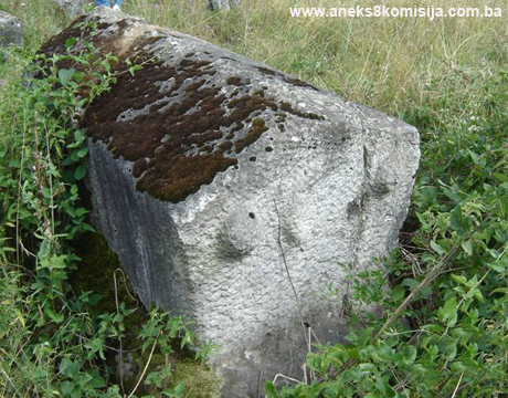
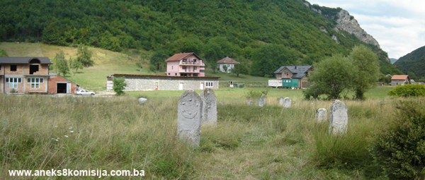
2. Description of the property
Until
1978 the entire complex was in Kovačevina, to the west of the Vojkovići-Trnovo
road. The old Muslim burial ground was to the south-east of the quarry in
Krupac. To the east of the burial ground was an Orthodox cemetery, with the
necropolis of stećci (pl. of stećak) forming an extension to it.
This sepulchral ensemble was at risk from the quarry workings, which were
steadily expanding towards the necropolis. Of the 37 stećci counted by Đuro
Basler in 1951, all that remained were 23, damaged and shifted from their
original positions. In 1976 the extraction of stone from the quarry extended
right up to the tombstones, leaving the necropolis on the edge of a 10-15 m
deep pit. To the south-west of the necropolis, a new rural road was laid. The
old rural road, which was still in constant use by the local people, ran
through the middle of the burial ground, dividing it into two. Many of the
nišan tombstones were broken in half(3).
The
necropolis with the stećci and the Muslim graves were moved to the east of the
road. There is a new Orthodox cemetery not far from the newly-located
tombstones.
The
tombstones were laid out on the new site over an area of about 55 m
(north-south) x 20 m, or 1100 m2. The group of nišan tombstones were relocated
to the northern part of the plot and the stećci were distributed over the
entire area.
On the
new site, there are 21 intact stećci: one gabled (no. 22), six gabled with
plinth (nos. 1, 10, 14, 16, 20, 23), nine chest-shaped (nos. 2, 4, 5, 7, 8, 11,
12, 17, 21), and five chest-shaped with plinth (nos. 3, 6, 13, 18, 19). There
is part of one stećak of which only the sunken base remains, so that its shape
is not known (no. 17), and part of the corner of a tombstone (no. 9).
The
stećci lie either west-east or north-south. The workmanship is crude, but there
was an obvious tendency on the part of the stonemason or the person
commissioning the tombstones to put the emphasis on size, or even to make
tombstones with plinths, of which there are almost as many as there are
without. Only one stećak is decorated, while one has a small rosette carved
onto the plinth. The decorations are in bas relief.
Necropolis of stećci
Stećak
no. 1 Gabled with plinth, measuring (chest) 1.45 m in length x 0.6 m in width x 0.3
m in height; plinth: 1.7 x 0.8 x 0.25 m. Lying W-E. Poor workmanship. The west
end of the gable and part of the plinth have been broken off.
Stećak
no. 2 Chest, measuring 1.7 x 0.6 x 0.4 m. Lying N-S. There are almost
no signs of the stonemason's work, with the natural shape of the stone barely
hewn.
Stećak
no. 3 Chest with plinth, measuring (chest) 1.5 x 0.8 x 0.27 m; (plinth)
1.9 x 1 x 0.15 m. Lying W-E.
Stećak
no. 4 Chest, sunken, measuring 1.8 x 0.9 x 0.2 m. Lying W-E.
Stećak
no. 5 Chest, measuring 1.5 x 0.77 x 0.35 m. Lying N-S.
Stećak
no. 6 Chest with plinth, measuring (chest) 1.2 x 0.8 x 0.8; (plinth)
1.4 x 1 x 0.2 m. The top surface is angled lengthwise to a height of 0.8 m to
the north to 0 m to the south. Lying N-S.
Stećak
no. 7 Chest, measuring 1.65 x 0.7 x 0.35 m. Lying W-E.
Stećak
no. 8 Chest, measuring 2.15 x 0.9 x 0.8 m. Lying W-E.
Stećak
no. 9 Broken-off corner of a stećak or remains of the corner of a
stećak.
Stećak
no. 10 Gabled with plinth. The sides of the gabled part narrow towards
the base. Measuring (gabled) 1.45 x 0.60
(0.56) x 0.8 (height of the gable itself is 0.2) m. Lying N-S.
Stećak
no. 11 Chest, measuring 1.9 x 1.2 x 0.8 m. Lying W-E.
Stećak
no. 12 Chest, measuring 1.9 x 1.07 x 0.4 m. Lying W-E.
Stećak
no. 13 Chest with plinth, measuring (chest) 1.46 x 0.64 x 0.36 m;
(plinth) 1.85 x 0.76 m, sunken. Lying N-S.
Stećak
no. 14 Gabled with plinth, measuring (gabled) 1.6 x 0.76 x 0.53 (height
of the gable itself is 0.06 m); (plinth) 2 x 1.2 x 0.3 m. Lying W-E. The long
side of the plinth has a small quadrifoil rosette.
Stećak
no. 15 Lower part of a broken stećak. Partly buried.
Stećak
no. 16 Gabled with plinth, measuring (gabled) 1.7 x 0.75 x 0.55 (height
of the gable itself is 0.1 m); (plinth) 1.9 x 0.85 x 0.25 m. Lying W-E.
Stećak
no. 17 Chest, measuring 1.8 x 0.65 x 0.43 m. Lying N-S.
Stećak
no. 18 Chest with plinth, measuring (chest) 1.7 x 0.73 x 0.5 m; (plinth)
2 x 0.9 x 0.13 m. Lying W-E.
Stećak
no. 19 Chest with plinth, measuring (chest):1.8 x 1.23 x 0.45 m;
(plinth) 2.16 x 1.45 x 0.12 m. Lying W-E.
Stećak
no. 20 Gabled with plinth, measuring (gabled) 1.55 x 0.78 (0.7) x 68
(height of the gable itself is 0.2 m); (plinth) 1.30 x 1 x 0.24 m. Lying W-E.
The ends are decorated: the west end has a crescent moon and the west [sic] end
has a crescent moon with two demiorbs. Bas relief.
Stećak
no. 21 chest with plinth, measuring (chest) 1.7 x 0.7 x 0.35, with the
plinth marked at the base by a projection of about 2 cm.
Stećak
no. 22 Gabled, partly buried, measuring 1.4 x 0.7 with just part of the
gable, to a height of 0.17 m, above ground Lying W-E
Stećak
no. 23 Gabled with plinth, measuring (gabled): length (in bushes), width
0.7, height 0.7 m. Lying W-E
Old Muslim burial ground
At
the northern end of the site is a group of 12 nišan tombstones and two short
stubs remaining from tombstones belonging to the burial ground (nos. 6 and 12).
Common to all these tombstones are: the shape of the nišans, dating from the
very earliest times, where there is still a strong influence from the
stonemasonry tradition of the stećak; bas-relief motifs transposed from stećak
tombstones; the absence of epitaphs; their location together with the stećak
tombstones; the careful workmanship of some of the tombstones. The shapes of
the nišan tombstones, either in the form of a stele with a gabled top, some of
which were topped by a demiorb, or in the form of pillars with prismatic tops
or a broken prism topped by a demiorb. All the decorations on the nišans are carved
in bas relief.
The
tombstones are erected with the wider faces (west and east) lying north-south.
The tombstones and the decorative motifs are worked in the same way. These
tombstones, and their location alongside a necropolis with stećak tombstones
(on their original site), have all the characteristics of the most ancient
nišan tombstones. There are nišans of these shapes in burial grounds in Sarajevo (at Alifakovac, by
the Ali pasha mosque, Hambina carina, in Lukavica, in Hrasnic, and in Trnovo –
in Govedovići and Turovi). The tombstones that most resemble these in shape and
decoration are those in the old burial ground in Hrasnica (which has
disappeared as this built-up neighbourhood expanded) and in Lukavica(4). It is impossible to determine
when exactly these tombstones came into being – it could have been as early as
the second half of the 15th century, when the Ottomans finally established
their rule in this area, or just before the 16th century. Nišan tombstones of
these shapes and with these decorations have been recorded throughout Bosnia and parts of Herzegovina, though this type of
tombstone has not been well studied(5).
The
report on the relocation of the necropolis and Muslim burial ground reveals
that only one grave was moved with its pair of tombstones (nos. 1 and 13 on the
plan). These two nišans certainly belonged to the same grave. The distance
between them is more than 3 m.
Nišan no.
1 Nišan in the form of a stele ending in a gable, measuring 1.4 m
in height (of which 0.3 m is the height of the gable) x 0.58 in width x 0.24 m
thick. The wider sides face east and west, the narrower north and south. The
top half of the west face is decorated with four demiorbs below which is a
crescent moon with its horns upwards, and the lower half with a sword and
another demiorb. The east face has three demiorbs on the top half with a
crescent moon below them, and another demiorb and a drawn bow with an arrow on
the lower half. The bottom of the north side has a mace and the south side two
demiorbs.
In a good
state of preservation, apart from a thin coat of moss on the narrower sides of
the gable and the top of the gable being broken off.
Nišan no.
2 Nišan in the form of a stele, the same as no. 1, measuring 1.38
(of which 0.25 is the height of the gable) x 0.46 x 0.36 m. The west face has a
crescent moon with its horns pointing upwards. The narrow north and south sides
each have a pair of demiorbs.
The
tombstone has a vertical crack.
Nišan no.
3 Nišan in the form of a stele, the same as nos.1 and 2, measuring
1.1.85 (of which 0.30 is the height of the gable) x 0.51 x 0.25 m. The west
face has a demiorb in the gable and a crescent moon with a demiorb below it on
the top half. The top half of the east side has two demiorbs with a crescent
moon centrally below them, with below it another demiorb. The narrower sides
each have a pair of demiorbs. At the top of these sides, the transition from
the gable to the slab is accentuated. There are cracks here and there, and the
top is covered with moss.
Nišan no.
4 Nišan in the shape of a block with the top corners rounded,
measuring 0.92 x 0.40 (0.37 at the base)
x 30 (0.35 at the base) m. Undecorated. There are cracks in several places
along the tombstone.
Nišan no.
5 Nišan in the shape of a block with a pyramidal top, measuring 1.3
(of which 0.35 is the height of the top) x 0.60 x 0.26 m. The ends of the
vertical sides have chamfered edges 2 cm wide. The west, north and east sides each
have a demiorb. There are quite large cracks on the top part of the nišan.
Nišan no.
6 piece of a nišan tombstone in the form of a cylindrical column,
diameter 0.2 m.
Nišan no.
7 Nišan in the form of a stele terminating in a gable, measuring
1.16 (of which the height of the gable is 0.2) x 0.45 x 0.19 m. Both narrower
sides are decorated with a sword. The top of the gable has been broken off, and
the body of the stele is cracked. There is a thin coat of moss here and there
on the tombstone.
Nišan no.
8 Nišan of the same shape as no. 7, measuring 1.18 (of which the
height of the gable is 0.3) x 0.37 x 0.24 m. The narrower sides of the gable
are damaged.
Nišan no.
9 Nišan in the shape of a block with a pyramidal top on which is a
demiorb. The tombstone measures 0.83 (of
which the height of the top is 0.13) x 0.34 x 0.25 m. The edges of the sides
are chamfered. A mace is carved on the north side. Minor damage can be seen on
the tombstone.
Nišan no.
10 Nišan in the form of a stele with the top part of the gable
knocked off. The surviving height is 0.62 (of which about 0.1 is the gable) x
0.30 x 018 m.
Nišan no.
11 Nišan in the form of a stele with an elongated gable, measuring
0.6 (of which the height of the gable is 0.24) x 0.40 x 0.19 m.
Nišan no.
12 Nišan in the form of a stele with a gable of which the top is
broken off. The surviving height is 0.69 (of which the height of the remaining
part of the gable is 0.13) x 0.3 x 0.1 m. There is a demiorb in the middle of
the east face. The north side of the tombstone is cracked vertically.
Nišan no.
13 piece of, probably, the top part of a stele with a rounded top.
The remains of the nišan measure 0.23 m in width and 0.3 m in height.
Nišan no.
14 Nišan in the shape of a block with a pyramidal top, measuring
0.62 (of which the height of the top is 0.2) x 0.29 x 0.22 m. The tip of the
tombstone is broken off.
3. Legal status to date
By Ruling
of the City Institute for the Protection of Cultural Monuments no. 552/76 or 8
December 1976, it was determined that the necropolis of stećak and nišan
tombstones in Krupac was of the nature of a cultural monument, and it was
placed under the protection of the social community.
The
collective valorization of the Regional Plan for Bosnia and Herzegovina to
2000, Stage B, Natural and Culturo-Historical Values, compiled in 1980, left
many burial grounds unrecorded, including the one in Krupac.
4. Research and conservation and
restoration works
From 10
to 12 August 1977, all the tombstones were moved to a new site, where
they are still. Twenty three stećak tombstones and 14 nišan tombstones were
moved. The works were carried out by experts from the City Institute for the
Protection of Cultural Monuments, Sarajevo.
It would
appear from the report that only one grave had both its nišan tombstones in
place (nos. 1 and 3 on the plan). The nišans (nos. 2 and 4 on the plan) that
were set up on the new site as a pair, had already been extracted from the
ground during World War II, serving as breastworks for some Italian
troops. The bones from the graves were placed in two coffins and buried between
nišan tombstones nos. 1 and 13 and 2 and 4 on the new site.
The
necessary conservation works were carried out on the nišan tombstones at the
time of their transfer to the new site.
5. Current condition of the
property
During an
on-site inspection in August 2007 it was found that the site is not kept
maintained. Some of the tombstones have cracks caused by natural factors. The
same was observed on the remains of two nišan tombstones. Signs of repairs can be seen on some of the
nišans.
6. Specific risks to which the
property is exposed
-
Natural factors will lead
to further deterioration.
-
Lack of maintenance.
III – CONCLUSION
Applying
the Criteria for the adoption of a decision on proclaiming an item of property
a national monument (Official Gazette of BiH nos. 33/02 and 15/03), the
Commission has enacted the Decision cited above.
The
Decision was based on the following criteria:
A. Time
frame
B. Historical value
C. Artistic and aesthetic value
C.i. quality of workmanship
C.iii. proportions
C.v. value of details
D. Clarity
(documentary, scientific and educational value)
D.i. material evidence of a lesser known
historical era
D.ii. evidence of historical change
E. Symbolic value
E.ii. religious value
E.iii. traditional value
E.v. significance for the identity of a group of
people
G. Authenticity
G.i. form and design of nišan tombstones
G.iv. traditions and techniques
G.vi. spirit and feeling
H. Rarity and representativity
H.i. unique or rare example of a certain type
or style
The
following documents form an integral part of this Decision:
-
Copy of cadastral plan
-
Copy of land register
entry
-
Photodocumentation
(photographs taken on site on 1 August 2007)
-
Plan of the necropolis (by
Adi Čorović)
Bibliography
During
the procedure to designate the monument as a national monument of Bosnia
and Herzegovina the following works were
consulted:
1947. Sergejevski, Dimitrije. “Arheološki nalazi u Sarajevu i okolici”
(Archaeological Finds in Sarajevo
and its Environs), Jnl of the National Museum in Sarajevo, new series
no. II. Sarajevo: 1947, 13-50.
1971. Bešlagić, Šefik. Stećci, kataloško-topografski pregled
(Stećak tombstones, a catalogue-cum-topographical survey). Sarajevo: 1971, 142-143.
1978. Bešlagić, Šefik. Nišani XV i XV vijeka u Bosni i Hercegovini
(15th and 16th century Nišan Tombstones in BiH). Sarajevo: Academy of Sciences
of Bosnia and Herzegovina, Transactions, Bk. LIII, Social Sciences Dept., bk.
30, 1978.
2005. Mušeta Ašćerić, Vesna. Sarajevo
i njegova okolina u XV stoljeću. Između istoka i zapada (Sarajevo and its Environs in the 15th Century. Between East
and West). Sarajevo:
2005.
(1) Sergejevski,
Dimitrije, “Arheološki nalazi u Sarajevu i okolici”, Jnl of the National Museum
in Sarajevo, n.s. no. II, Sarajevo:
1947, 47.
(2) Mušeta Ašćerić,
Vesna, Sarajevo
i njegova okolina u XV stoljeću. Između istoka i zapada. Sarajevo: 2005, 80.
(3) Bešlagić,
Šefik, Stećci, kataloško-topografski pregled. Sarajevo,
1971; and documentation from the Cantonal Institute for the Protection of the
Cultural and Natural Heritage, Sarajevo
(4) Bešlagić,
Šefik, Nišani XV i XV vijeka u Bosni i Hercegovini, Sarajevo: Academy of
Sciences of Bosnia and Herzegovina, Transactions, vol. LIII, Social Sciences
Dept., vol. 30, 1978, 24-30.
(5) Bešlagić,
Šefik, op.cit, 1978.