Status of monument -> National monument
Published in the “Official Gazette of BiH” no. 32/09.
Pursuant to Article V para. 4 Annex 8 of the General Framework Agreement for Peace in Bosnia and Herzegovina and Article 39 para. 1 of the Rules of Procedure of the Commission to Preserve National Monuments, at a session held from 6 to 9 March 2007 the Commission adopted a
D E C I S I O N
I
The historic ensemble of the old Bjelaj (Bilaj) fort in Bjelaj, Municipality Bosanski Petrovac, is hereby designated as a National Monument of Bosnia and Herzegovina (hereinafter: the National Monument).
The National Monument consists of a fortress dating from the late mediaeval and Ottoman periods and the prehistoric hillforts known as Velika and Mala gradina.
The National Monument is located on a site designated as cadastral plot no. 32/91-1 (old survey), Title Deed no. 110, cadastral municipality Bjelaj, Municipality Bosanski Petrovac, Federation of Bosnia and Herzegovina, Bosnia and Herzegovina.
The provisions relating to protection measures set forth by the Law on the Implementation of the Decisions of the Commission to Preserve National Monuments, established pursuant to Annex 8 of the General Framework Agreement for Peace in Bosnia and Herzegovina (Official Gazette of the Federation of BiH nos. 2/02, 27/02 and 6/04) shall apply to the National Monument.
II
The Government of the Federation of Bosnia and Herzegovina (hereinafter: the Government of the Federation) shall be responsible for ensuring and providing the legal, scientific, technical, administrative and financial measures necessary to protect, conserve, and display the National Monument.
The Commission to Preserve National Monuments (hereinafter: the Commission) shall determine the technical requirements and secure the funds for preparing and setting up signboards with the basic data on the monument and the Decision to proclaim the property a National Monument
III
To ensure the on-going protection of the National Monument in the site defined in Clause 1 para. 3 of this Decision and the plateau with Velika and Mala gradina hillforts to the north of the fortress, the following measures are hereby stipulated:
- research and conservation and restoration works, routine maintenance works, and works designed to display the monument shall be permitted, subject to the approval of the Federal Ministry responsible for regional planning (hereinafter: the relevant ministry) and under the expert supervision of the heritage protection authority of the Federation of Bosnia and Herzegovina (hereinafter: the heritage protection authority),
- the site of the National Monument shall be open and accessible to the public, and may be used for educational and cultural purposes,
- works of any kind to the infrastructure are prohibited unless with the approval of the relevant ministry and under the expert supervision of the heritage protection authority,
- the construction of full-profile roads, houses or any buildings or facilities the erection or operations of which could be detrimental to the National Monument is prohibited,
- the dumping of waste is prohibited
The Government of the Federation shall be responsible in particular for ensuring that the following measures are implemented:
- repairing the National Monument,
- drawing up and implementing a programme for the presentation of the National Monument.
IV
All executive and area development planning acts not in accordance with the provisions of this Decision are hereby revoked.
V
Everyone, and in particular the competent authorities of the Federation of Bosnia and Herzegovina, the Canton, and urban and municipal authorities, shall refrain from any action that might damage the National Monument or jeopardize the preservation and rehabilitation thereof.
VI
The Government of the Federation, the relevant ministry, the heritage protection authority, and the Municipal Authorities in charge of urban planning and land registry affairs, shall be notified of this Decision in order to carry out the measures stipulated in Articles II to V of this Decision, and the Authorized Municipal Court shall be notified for the purposes of registration in the Land Register.
VII
The elucidation and accompanying documentation form an integral part of this Decision, which may be viewed by interested parties on the premises or by accessing the website of the Commission (http://www.aneks8komisija.com.ba)
VIII
Pursuant to Art. V para 4 Annex 8 of the General Framework Agreement for Peace in Bosnia and Herzegovina, decisions of the Commission are final.
IX
On the date of adoption of this Decision, the National Monument shall be deleted from the Provisional List of National Monuments of Bosnia and Herzegovina (Official Gazette of BiH no. 33/02, Official Gazette of Republika Srpska no. 79/02, Official Gazette of the Federation of BiH no. 59/02, and Official Gazette of Brčko District BiH no. 4/03), where it featured under serial no. 120.
X
This Decision shall enter into force the day after its publication in the Official Gazette of BiH.
This Decision has been adopted by the following members of the Commission: Zeynep Ahunbay, Amra Hadžimuhamedović, Dubravko Lovrenović, Ljiljana Ševo and Tina Wik.
No: 05.2-2-39/07-2
7 March 2007
Sarajevo
Chair of the Commission
Ljiljana Ševo
E l u c i d a t i o n
I – INTRODUCTION
Pursuant to Article 2, paragraph 1 of the Law on the Implementation of the Decisions of the Commission to Preserve National Monuments, established pursuant to Annex 8 of the General Framework Agreement for Peace in Bosnia and Herzegovina, a “National Monument” is an item of public property proclaimed by the Commission to Preserve National Monuments to be a National Monument pursuant to Articles V and VI of Annex 8 of the General Framework Agreement for Peace in Bosnia and Herzegovina and property entered on the Provisional List of National Monuments of Bosnia and Herzegovina (Official Gazette of BiH no. 33/02) until the Commission reaches a final decision on its status, as to which there is no time limit and regardless of whether a petition for the property in question has been submitted or not.
The Commission to Preserve National Monuments issued a Decision to add the historic ensemble of the mediaeval Bjelaj (Bilaj) fort to the Provisional List of National Monuments of Bosnia and Herzegovina, numbered as 120.
Pursuant to the provisions of the law, the Commission proceeded to carry out the procedure for reaching a final decision to designate the Property as a National Monument, pursuant to Article V para. 4 of Annex 8 and Article 35 of the Rules of Procedure of the Commission to Preserve National Monuments.
II – PROCEDURE PRIOR TO DECISION
In the procedure preceding the adoption of a final decision to proclaim the property a national monument, the following documentation was inspected:
- Documentation on the location and current owner and user of the property (copy of cadastral plan and copy of land register entry);
- Data on the current condition and use of the property, including a description and photographs, data of war damage, data on restoration or other works on the property, etc.;
- Historical, architectural and other documentary material on the property, as set out in the bibliography forming part of this Decision.
The findings based on the review of the above documentation and the condition of the site are as follows:
1. Details of the property
Location
The Bjelaj (Bilja) fort is located at the edge of the Bjelaj plain. The road to Kulen Vakuf branches off from the Bosanski Petrovac-Bihać road at Vrtoče, and a side road leads from this road to the village of Bjelaj. By the Orthodox church, the road climbs to the Bjelaj (Bilaj) fort, a distance of about 1.7 km. The fort stands on the northern foothills of Mt. Osječenica, surrounding the Bjelaj plain to the west. The area around the fort itself is uninhabited wasteland.
The National Monument is located on a site designated as cadastral plot no. 32/91-1 (old survey), Title Deed no. 110, cadastral municipality Bjelaj, Municipality Bosanski Petrovac, Federation of Bosnia and Herzegovina, Bosnia and Herzegovina.
Historical information
The earliest reference to the Bjelaj (Bilaj) fort in written sources dates from 1495. In 1528, with the conquest of Jajce, Ottoman troops dispersed around the region of present-day north-western Bosnia. They were routed at Bjelaj (Bilaj) by troops commanded by ban (governor) Ivan Karlović and the brothers Vuk and Krsto Frankopan (Truhelka, 1912, 130; Kreševljaković, 1953, 40). On 29 July 1573 the Ottomans conducted a raid and assembled troops in the Bjelaj plain with the intention of making an assault on the fort in Bihać (Lopašić, 1943, 245; Vego, 1957, 11).
Bjelaj (Bilaj) came under Ottoman rule between 1530 and 1537. It was merged with the Bosnian sandžak and vilayet and the Neretva kadiluk. By 1540 there is already reference to the nahija (smallest administrative unit) of Bjelaj, and somewhat later to the nahija of Bjelaj-Blagaj, but it soon came under the Kamengrad kadiluk, referred to as a kadiluk in the Bosnian or the Klis sandžak. In 1562 the Bjelaj nahija was merged with the Novosel kadiluk, which was in the Klis sandžak. From the later 17th and early 18th century, the nahija of Bjelaj or Bjelaj-Blagaj is listed in the censuses of both the Bosnian and the Klis sandžaks. It is listed in the Klis sandžak as belonging to the Novosel kadiluk, and in the Bosnian sandžak as coming under the Kamengrad kadiluk (Šabanović, 1982, 181, 216, 228).
The Bjelaj fort housed a permanent garrison under a dizdar (garrison commander). In 1577, it was recorded that the fortress housed a garrison of 370 Ottoman merceneries. In September 1584, part of the Senj and Slunj frontier garrison penetrated deep into Ottoman territory, as far as Bjelaj and Novi on the Una (Kruhek, 1995, 325-326). After 1592, the fort was in the Bihać captaincy, and from the 18th century it became part of the Petrovac captaincy. The Bjelaj (Bilaj) commander, Alijaga, was a member of the Border Commission to agree the borders with Venice. On 19 July 1737 part of the Austrian army, which was making inroads into Bosnia from several directions, was defeated at Bjelaj. The commander of the Bosnian troops was Alibeg Omerpašić, who was killed in the battle of Bjelaj (Bilaj). In 1747 Bjelaj (Bilaj) had a garrison of 30, under dizdar Hasanaga. According to an inventory of the fort and its arms and ammunition taken in 1833, Bjelaj had one 12 in. cannon and three smaller 6 in.
2. Description of the property
The Bjelaj (Bilaj) fort was named on account of its striking whiteness (bjelina, bijela or bila boja), which made it so visible above the Bjelaj plain.There are several forts in Bosnia and Herzegovina with names incorporating a reference to whiteness, among them Biograd (Akhsar) and Biograci.
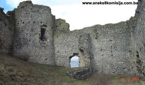
The entire complex stands on the summit of a hill on a plateau that runs north-south over a length of about 850 m. The plateau consists of a wider northern half and a narrower southern half of equal lengths. The large hillfort known as Velika gradina is located at the southern end of the northern half of the plateau; this prehistoric site dating from the Bronze and Iron Ages has as yet been insufficiently investigated. The southern part of the plateau, which is much narrower than the northern, is tongue-shaped. To the north of this half is the prehistoric site of Mala gradina, the small hillfort, which has not been investigated. To the south of this stands the large Ottoman and mediaeval fort of Bjelaj or, as older works call it, Bilaj. It covers an area of more than 150 m in length and 40 m in width. The fort is easily reached from the western slope below which is the road running from the Orthodox church in Bjelaj over the foothills and Mt. Osječenica towards Kolunić.
The Bjelaj (Bilaj) fort consists of two parts: the southern mediaeval fort, and the northern Ottoman part. The mediaeval fort forms an irregular rectangle, more than 40 m long (north-south) and about 35 m wide (east-west). The entrance to the fort is in the north rampart. It is round-arched, with part of the arch and doorjambs surviving. There is a massive round tower at the north-west corner, two-thirds of which projects out from the ramparts; the tower is about 16 m in height. The entrance to the tower is at a height of about 4 metres above the present ground level. Judging from the outer revetment, the interior of the tower was probably divided into three levels: a ground floor or basement, a room at entrance level, and a room above the entrance, since an unbroken series of apertures for floor joists can be seen in the facing of the rampart. To the east of the entrance are the remains of a narrow, hollow, walled area of the same height as the rampart (15-16 m). This was built on against the rampart. All that survives of it is the upper part; it was probably used to provide the troops with access to the top of the wall, where there were breastworks and a few small loopholes. The remains of the eastern part of the longitudinal wall forming part of a single structure with the vertical remains of the wall just described, by the ramparts, can be seen on the ground. These remains of the wall on the ground divide the narrower eastern part of the interior of the fort from the western part. A few metres away to the south they disappear, while to the west, facing the tower, there is no sign of them. The impression gained is that this was part of a walled-off area protecting the entrance to the interior of the fort. The west side of the fort was harder to defend because enemy forces could come at it from behind. The west rampart is thus monolithic and topped by breastworks, of which only a small part has survived. Below the level of the breastworks, a series of stone brackets at the top of the rampart, on which a wooden walkway once rested, can still be seen. Below these again is a row of shorter brackets built into the rampart. The east rampart faced the Bjelaj plain. It contains four large, round-arched loopholes, constructed in such a way that men standing on wooden or stone platforms could fire through them. On the inside of the ramparts, the vertical and horizontal stone blocks and slabs of fine workmanship that formed the frames can be seen on some of the loopholes. Above the loopholes is a horizontal row of holes for joists, above which are the stone brackets. These ramparts provide a view of the entire Bjelaj plain and its surroundings. The south rampart is in a total state of ruin. There are the remains of a cistern by the tower beside the west rampart. The ramparts and tower of the older fortress were built of tufa blocks and quarry stone. There is a moat outside the north rampart and the entrance to the old part of the fort. Though now filled in, its outlines can still be made out.
The remains of a large bailey built onto the mediaeval fort in Ottoman times begin at the tower to the west. The bailey is to the north of the older part of the fort, and forms an almost regular rectangle 110 m in length and about 40 m in width. All that survives are parts of the west rampart of the bailey, in places to a height of 2 m.
They are completely different in building materials from the ramparts of the mediaeval fort, being built of smaller quarry stone blocks bonded with large quantities of mortar. The bailey contained a small mosque, which was observed by Ćurčić in 1902. The site of the mosque now consists of a hollow filled with a heap of stone. According to Ćurčić, the entrance to the bailey was in the north wall, and had a pointed arch (Ćurčić, 1902, 233-234). Here the remains, or the mere traces, of the ramparts can barely be seen above ground. The best preserved part of the Ottoman ramparts is to the south and north of the mediaeval moat, along the western edge of the plateau. Judging from the end of one part of the west rampart, it would seem that there was another entrance in that wall, north of the moat. The rampart along the eastern edge has not survived.
3. Legal status to date
The ruins of the old fort in Bilaj (Bjelaj) were placed under state protection by Ruling no. 152/51 of 1 February 1951 of the Institute for the Protection of Cultural Monuments and Natural Rarities of the People’s Republic of Bosnia and Herzegovina, Sarajevo. By Ruling of the same Institute no. 02-842-3 of 18 April 1972 the monument was entered in the Register of Immovable Cultural Monuments.
The Regional Plan for Bosnia and Herzegovina to 2000, drawn up in 1980; Stage B - valorization of natural, cultural and historical monuments, listed the old Bilaj fort as a category I monument.
The property is on the Provisional List of National Monuments of the Commission to Preserve National Monuments as the Bosanski Petrovac – Bilaj (Bjelaj) – mediaeval fort, under no. 120.
4. Research and conservation and restoration works
None.
5. Current condition of the property
During an on site inspection conducted in February 2007 it was found that the mediaeval fort is still in a fairly good state of preservation, but that all that remains of the Ottoman bailey is parts of the west wall. Gaps can be seen in the ramparts of the mediaeval fort where the stone has been removed.
6. Specific risks
The National Monument is at risk of deterioration from neglect, lack of maintenance, and the absence of a suitable management plan.
III – CONCLUSION
Applying the Criteria for the adoption of a decision on proclaiming an item of property a national monument (Official Gazette of BiH nos. 33/02 and 15/03), the Commission has enacted the Decision cited above.
The Decision was based on the following criteria:
A. Time frame
B. Historical value
C. Artistic and aesthetic value
C.iii. proportions
C.v. value of details
C.vi. value of construction
D. Clarity (documentary, scientific and educational value)
D.i. material evidence of a lesser known historical era
D.ii. evidence of historical change
D.iv. evidence of a particular type, style or regional manner
F. Townscape/ Landscape value
F.iii. the building or group of buildings is part of a group or site
G. Authenticity
G.v. location and setting
H. Rarity and representativity
H.i. unique or rare example of a certain type or style
The following documents form an integral part of this Decision:
- Copy of cadastral plan;
- Copy of land register entry;
- Photodocumentation of the Commission, photographs taken on site in February 2007;
- Two maps.
Bibliography
During the procedure to designate the monument as a national monument of Bosnia and Herzegovina the following works were consulted:
1902. Ćurčić, Vejsil, “Starine iz okoline Bosanskog Petrovca” (Antiquities from the Bosanski Petrovac area), Jnl. of the National Museum of Bosnia and Herzegovina XIV, Sarajevo, 1902, 229-241.
1912. Truhelka, Ćiro, “Gazi Husrefbeg, njegov život i njegovo doba” (Gazi Husrev bey, His Life and Times), Jnl. of the National Museum of Bosnia and Herzegovina XXIV, Sarajevo, 1912, 92-233.
1943. Lopašić, Radoslav, Bihać i Bihaćka krajina (Bihać and the Bihać Frontier Region), 2nd ed, Zagreb 1943.
1952. Kreševljaković, Hamdija, Prilozi povijesti bosanskih gradova pod turskom upravom. Prilozi za orijentalnu filologiju i istoriju jugoslovenskih naroda pod turskom vladavinom (Contributions to the History of Bosnian Towns under Turkish Administration, Contributions for Oriental Philology and the History of the South Slavs under Turkish Governance), II/1951, Institute for Oriental Studies in Sarajevo, Sarajevo, 1952,119-184.
1953. Kreševljaković, Hamdija, “Stari bosanski gradovi” (Old Bosnian Forts), Naše starine I, Sarajevo, 1953, 7-45.
1957. Vego, Marko, Naselja srednjovjekovne bosanske države (Settlements of the mediaeval Bosnian state), Svjetlost, Sarajevo, 1957, 11.
1982. Šabanović, Hazim, Bosanski pašaluk, postanak i upravna podjela (Bosnian Pashaluk, origins and administrative division), Svjetlost, Sarajevo, 1982
1995. Kruhek, Milan, Krajiške utvrde i obrana hrvatskog kraljevstva tijekom 16. stoljeća (Frontier Forts and the Defence of the Croatian Kingdom in the 16th Century), Zagreb, 1995.
|