Status of monument -> National monument
Published in the Official Gazette of BiH no. 1/10.
Pursuant to Article V para. 4 Annex 8 of the General Framework Agreement for Peace in Bosnia and Herzegovina and Article 39 para. 1 of the Rules of Procedure of the Commission to Preserve National Monuments, at a session held from 7 to 10 November 2006 the Commission adopted a
D E C I S I O N
I
The historic site of the Lower Fort in Srebrenica, Municipality Srebrenica, is hereby designated as a National Monument of Bosnia and Herzegovina (hereinafter: the National Monument).
The National Monument consists of the ruins of an artillery fortress dating from the Ottoman period.
The National Monument is located on a site designated as cadastral plot no. c.p. 1182, title deed no. 497 (new survey), corresponding to c.p. 365/1 (old survey), Land Register entry no. 94, c.p. 1183, title deed no. 497 (new survey), corresponding to c.p. 365/1 and 365/7 (old survey) Land Register entry no. 94 and 1247, c.p. 1184, 1185, title deed no. 65 (new survey), corresponding to c.p. 322 (old survey), Land Register entry no. 589, c.p. 1186 (new survey), title deed no. 76 , corresponding to c.p. 348 and 349 (old survey), Land Register entry no. 8, part of c.p. 1198, title deed no. 148 (new survey), corresponding to c.p. 365/6 (old survey), Land Register entry no. 982, part of c.p. 1198, title deed no. 508 (new survey), corresponding to c.p. 365/2 (old survey), Land Register entry no. 982, c.p. 1199 (new survey), title deed no. 64, corresponding to c.p. 365/3 (old survey), Land Register entry no. 1246, c.p. 1200 (new survey), title deed no. 497, corresponding to c.p. 365/8 (old survey), Land Register entry no. 1245, c.p. 1201/1 (new survey), title deed no. 76, corresponding to c.p. 348 (old survey), Land Register entry no. 8, part of c.p. 1359 (new survey), title deed no. 65, corresponding to c.p. 321/2 and 321/4 (old survey), Land Register entry no. 9, part of c.p. 1359 (new survey), title deed no. 65, corresponding to c.p. 321/3 (old survey), Land Register entry no. 353, part of c.p. 1359 (new survey), title deed no. 65, corresponding to c.p. 322 (old survey), Land Register entry no. 589, part of c.p. 1360 and 1362 (new survey), title deed no. 65 , corresponding to c.p. 321/1 (old survey), Land Register entry no. 353, part of c.p. 1362 (new survey), title deed no. 65, corresponding to c.p. 321/2 (old survey), Land Register entry no. 9, part of c.p. 1362 (new survey), title deed no. 65, corresponding to c.p. 352 (old survey), Land Register entry no. 699, part of c.p. 1362 (new survey), title deed no. 65, corresponding to c.p. 355 (old survey), Land Register entry no. 571, c.p. 344 (old survey), Land Register entry no. 10, c.p. 345/1 (old survey), Land Register entry no. 9, c.p. 245/2 (old survey),Land Register entry no. 1191, part of c.p. 1362 (new survey), title deed no. 65, corresponding to c.p. 354 (old survey), Land Register entry no. 464, c.p. 1364 (new survey), corresponding to c.p. 323 (old survey), Land Register entry no. 10, part of c.p. 1809 (new survey), corresponding to c.p. 337 (old survey), Land Register entry no. 982, cadastral municipality Srebrenica, Municipality Srebrenica, Republika Srpska, Bosnia and Herzegovina.
The provisions relating to protection measures set forth by the Law on the Implementation of the Decisions of the Commission to Preserve National Monuments, established pursuant to Annex 8 of the General Framework Agreement for Peace in Bosnia and Herzegovina (Official Gazette of Republika Srpska no. 9/02) shall apply to the National Monument.
II
The Government of Republika Srpska shall be responsible for providing the legal, scientific, technical, administrative and financial measures necessary for the investigation, protection, conservation and presentation of the National Monument.
The Commission to Preserve National Monuments (hereinafter: the Commission) shall determine the technical requirements and secure the funds for preparing and setting up signboards with basic details of the monument and the Decision to proclaim the property a National Monument.
III
To ensure the on-going protection of the National Monument on the area defined in Clause 1 para. 3 of this Decision, the following measures are hereby prescribed:
Protection Level I applies to c.p. 321/1, c.p. 321/3, c.p. 321/4, part of c.p. 322, part of c.p. 348, c.p.349, c.p. 365/6 and 365/1. The following protection measures shall apply to this protection level:
- works on the infrastructure are prohibited except with the approval of the ministry responsible for regional planning in Republika Srpska and subject to the expert opinion of the heritage protection authority of Republika Srpska;
- works that could have the effect of altering the site or the surrounding landscape are prohibited;
- buildings and structures post-dating the 1992-1995 war shall be removed with care to avoid damaging the National Monument;
- the ramparts of the fort, the walls of the towers, the other areas and the surroundings shall be cleared of wild plants and grime caused by the effects of the elements and posing a threat to the structure of the monument;
- the towers and ramparts shall be rendered structurally sound where cracks have appeared that could cause the entire structure to collapse;
- during structural repair, conservation and restoration works, original materials and binders shall be used wherever possible;
- during the repair works, existing stone blocks shall be used to make good the various parts of the fortress;
- the surface finish of the repaired areas shall correspond to that of the rest of the wall;
- the crown of the wall must be capped using natural materials (stone capping or hydraulic lime mortar finish);
- major cracks must be filled with a compound of small pieces of stone and hydraulic lime mortar;
- self-sown vegetation shall be removed;
- archaeological explorations shall be carried out within the fortress followed by conservation works on any remains discovered;
- a programme for the presentation of the National Monument shall be drawn up and implemented;
- the site of the monument shall be open and accessible to the public and may be used for educational and cultural purposes.
Protection Level II applies to part of c.p. 321/1, c.p. 321/2, part of c.p. 322, c.p. 323, 337, 344, 345/1, 345/2, part of c.p. 348, c.p. 352, 354, 355, 365/1, 365/3 and 365/8. The following protection measures shall apply to this area:
- the rehabilitation and repair of damaged properties is permitted, subject to retaining their existing height and footprint;
- the dumping of waste is prohibited.
IV
All executive and area development planning acts not in accordance with the provisions of this Decision are hereby revoked.
V
Everyone, and in particular the competent authorities of Republika Srpska and urban and municipal authorities, shall refrain from any action that might damage the National Monument or jeopardize the preservation thereof.
VI
The Government of Republika Srpska, the Ministry responsible for regional planning in Republika Srpska and the heritage protection authority of Republika Srpska, and the Municipal Authorities in charge of urban planning and land registry affairs, shall be notified of this Decision in order to carry out the measures stipulated in Articles II – V of this Decision, and the Authorized Municipal Court shall be notified for the purposes of registration in the Land Register.
VII
The elucidation and accompanying documentation form an integral part of this Decision, which may be viewed by interested parties on the premises or by accessing the website of the Commission (http://www.aneks8komisija.com.ba)
VIII
Pursuant to Art. V para 4 Annex 8 of the General Framework Agreement for Peace in Bosnia and Herzegovina, decisions of the Commission are final.
IX
This Decision shall enter into force on the day following its publication in the Official Gazette of BiH.
This Decision has been adopted by the following members of the Commission: Zeynep Ahunbay, Amra Hadžimuhamedović, Dubravko Lovrenović, Ljiljana Ševo and Tina Wik.
No: 05.2-2-104/04-6
8 November 2006
Sarajevo
Chair of the Commission
Ljiljana Ševo
E l u c i d a t i o n
I – INTRODUCTION
Pursuant to Article 2, paragraph 1 of the Law on the Implementation of the Decisions of the Commission to Preserve National Monuments, established pursuant to Annex 8 of the General Framework Agreement for Peace in Bosnia and Herzegovina, a “National Monument” is an item of public property proclaimed by the Commission to Preserve National Monuments to be a National Monument pursuant to Articles V and VI of Annex 8 of the General Framework Agreement for Peace in Bosnia and Herzegovina and property entered on the Provisional List of National Monuments of Bosnia and Herzegovina (Official Gazette of BiH no. 33/02) until the Commission reaches a final decision on its status, as to which there is no time limit and regardless of whether a petition for the property in question has been submitted or not.
On 26 July 2006 the relevant department of Srebrenica Municipality submitted a petition/proposal to designate the Lower Fort in Srebrenica as a National Monument of Bosnia and Herzegovina.
Pursuant to the provisions of the law, the Commission proceeded to carry out the procedure for reaching a final decision to designate the Property as a National Monument, pursuant to Article V of Annex 8 and Article 35 of the Rules of Procedure of the Commission to Preserve National Monuments.
II – PRELIMINARY PROCEDURE
In the procedure preceding the adoption of a final decision to proclaim the property a national monument, the following documentation was inspected:
- Documentation on the location and current owner and user of the property (copy of cadastral plan and copy of land registry entry);
- Data on the current condition and use of the property, including a description and photographs, data of war damage, data on restoration or other works on the property, etc;
- Historical, architectural and other documentary material on the property, as set out in the bibliography forming part of this Decision.
The findings based on the review of the above documentation and the condition of the site are as follows:
1. Details of the property
Location
Srebrenica, in the central Drina valley, is a small town located in a narrow valley between densely forested hills not exceeding 600 m in altitude. The town itself is at an altitude of 448 m above sea level. Here the two minor water courses of Crvena rijeka (Red River) and Čičavac meet. Access to Srebrenica is via Bratunac, through the narrow valley of the little river Sušica. At the eastern margin of the town of Srebrenica is a mountainside sloping down gradually towards the town. Here, on the topmost terrace, are the ruins of a mediaeval fortress referred to in the literature as Srebrenik in Srebrenica or as the Old Fort. On a plateau somewhat lower down the same slope is a fortress built during the Ottoman period, known both in the literature and by elderly inhabitants of Srebrenica as the Lower Fort. The present-day inhabitants of Srebrenica simply call it the Old Fort.
The National Monument is located on a site designated as cadastral plot no. c.p. 1182, title deed no. 497 (new survey), corresponding to c.p. 365/1 (old survey), Land Register entry no. 94, c.p. 1183, title deed no. 497 (new survey), corresponding to c.p. 365/1 and 365/7 (old survey) Land Register entry no. 94 and 1247, c.p. 1184, 1185, title deed no. 65 (new survey), corresponding to c.p. 322 (old survey), Land Register entry no. 589, c.p. 1186 (new survey), title deed no. 76 , corresponding to c.p. 348 and 349 (old survey), Land Register entry no. 8, part of c.p. 1198, title deed no. 148 (new survey), corresponding to c.p. 365/6 (old survey), Land Register entry no. 982, part of c.p. 1198, title deed no. 508 (new survey), corresponding to c.p. 365/2 (old survey), Land Register entry no. 982, c.p. 1199 (new survey), title deed no. 64, corresponding to c.p. 365/3 (old survey), Land Register entry no. 1246, c.p. 1200 (new survey), title deed no. 497, corresponding to c.p. 365/8 (old survey), Land Register entry no. 1245, c.p. 1201/1 (new survey), title deed no. 76, corresponding to c.p. 348 (old survey), Land Register entry no. 8, part of c.p. 1359 (new survey), title deed no. 65, corresponding to c.p. 321/2 i 321/4 (old survey), Land Register entry no. 9, part of c.p. 1359 (new survey), title deed no. 65, corresponding to c.p. 321/3 (old survey), Land Register entry no. 353, part of c.p. 1359 (new survey), title deed no. 65, corresponding to c.p. 322 (old survey), Land Register entry no. 589, part of c.p. 1360 and 1362 (new survey), title deed no. 65 , corresponding to c.p. 321/1 (old survey), Land Register entry no. 353, part of c.p. 1362 (new survey), title deed no. 65, corresponding to c.p. 321/2 (old survey), Land Register entry no. 9, part of c.p. 1362 (new survey), title deed no. 65, corresponding to c.p. 352 (old survey), Land Register entry no. 699, part of c.p. 1362 (new survey), title deed no. 65, corresponding to c.p. 355 (old survey), Land Register entry no. 571, c.p. 344 (old survey), Land Register entry no. 10, c.p. 345/1 (old survey), Land Register entry no. 9, c.p. 245/2 (old survey),Land Register entry no. 1191, part of c.p. 1362 (new survey), title deed no. 65, corresponding to c.p. 354 (old survey), Land Register entry no. 464, c.p. 1364 (new survey), corresponding to c.p. 323 (old survey), Land Register entry no. 10, part of c.p. 1809 (new survey), corresponding to c.p. 337 (old survey), Land Register entry no. 982, cadastral municipality Srebrenica, Municipality Srebrenica, Republika Srpska, Bosnia and Herzegovina.
Historical information
The Srebrenica region has been known since Antiquity for silver mining. The remains were discovered in nearby Sase on Gradina of the sizeable Roman and late Antique municipium of Domavia, which was the centre of mining administration for the provinces of Pannonia and Dalmatia. In mediaeval times, such was the demand for silver in Europe that Srebrenica was one of the most advanced mining and trading settlements in the mediaeval Bosnian state, thanks to its wealth of silver-bearing ore. Srebrenica was also one of the largest mines in the Balkans. The earliest reference to it as a mine dates from 1352, at the end of Ban (governor) Stjepan II's rule(1). The settlement began to develop in the second half of the 14th century, reaching a peak in the first half of the 15th as a major and busy trading centre.
Srebrenica originally belonged to the crown lands, and later to the Kovačević lands. In 1411 Hungary's King Sigismund took Srebrenica and bestowed it on the Serbian despot Stefan Lazarević. None of the efforts of the kings of Bosnia to regain possession of this important mine, by war or incursions, met with lasting success: Srebrenica remained for the most part within the despotate until it came under Ottoman rule. None of these events prevented the mining industry from continuing to develop, however, and with it the growth of the urban settlement of Srebrenica. By the early decades of the 15th century Srebrenica was the largest mine in the Balkans, along with Novo Brdo. The value of customs duty in Srebrenica rose by seven and a half times by comparison with Tvrtko I's reign. In addition to mining, trade also developed considerably, and new settlements sprang up around Srebrenica in the central Drina valley. Trade transit through the region to Hungary and Serbia also increased. Members of the Dubrovnik colony were particularly active at this time, and their colony became one of the most important in the Balkans(2).
As time passed and civilian urban settlement increased, the need arose to build fortresses for defence. In addition, there was constant tension between the Bosnian and the Serbian sides around Srebrenica, while the Ottomans were also drawing ever nearer (Srebrenica was first occupied in 1439-1440).
Though there is ample information about the town of Srebrenica, reflecting its importance, there are barely any references to the mediaeval fortress in historical sources. The earliest reference to the Srebrenik fort on the heights above Srebrenica dates from 1425, when the Bosnian army under King Tvrtko II attacked Srebrenica. The Serbian despot reacted swiftly and drove back the Bosnian troops. There is reference to the people from Dubrovnik living or visiting Srebrenica at that time retreating into the fortress, and to the fact that one of the cannon that despot Stefan captured was left in the fortress in Srebrenica(3). The Srebrenica fortress features in Dubrovnik documents on a number of other occasions: in May 1444, when the Bosnian king took “castri Strebrnich”(4); in 1448 when Dubrovnik merchants complained to the Dubrovnik government about the order from Bosnia's king Tomaš that they must build houses in the fortress, which was to be implemented by protovestiar Restoje; and in 1451 in relation to a serious dispute between King Tomaš and Despot Đurđe in which several actors were involved(5).
The Upper or Old Fort is completely in ruins, and overgrown with vegetation. In the late 1970s, parts of the keep and the outlines of a number of smaller buildings could still be made out.
After the occupation of Srebrenica by the Ottomans the town slowly but surely began to stagnate, and then to experience a general decline. Once Zvornik had fallen to the Ottomans, the region around the Drina and the central Drina valley was also conquered. From 1462 on, there was a constant Ottoman presence in Zvornik and Srebrenica. Srebrenica belonged to the Smederevo sanjak, which also included Zvornik, Kušlat and Šurbin on the left bank of the Drina, as can be seen from the first census of the Smederevo sanjak, conducted in 1476-1478(6). When the Zvornik sanjak was founded, these towns on the left bank of the Drina constituted its original heartland. The Zvornik sanjak was founded after 1478, but before 1483. According to Šabanović, it was probably founded after Vuk Grgurević's attack on Srebrenica and Sarajevo in 1476(7). Until the Bosnian pashaluk was founded in 1580, the Zvornik sanjak belonged to the Buda pashaluk; but from then on it remained part of the Bosnian pashaluk until the end of Ottoman rule.
After Zvornik and its surroundings were taken in 1462, the Srebrenica kadiluk (area under the jurisdiction of a qadi) was founded as part of the Smederevo sanjak (1462-1480), and from 1480 on it became part of the Zvornik sanjak. The headquarters of the kadiluk was in Srebrenica which, along with the Srebrenik fort, was in the nahija (smaller administrative unit) of Srebrenica(8). In the mid 16th century the Zvornik kadiluk was split off from the Srebrenica kadiluk.
There is no reference to the nahija of Srebrenica, which included the Srebrenik fort, the urban settlement of Srebrenica, and the surrounding areas, until 1533. After conquering the town, the Ottomans immediately stationed their own garrison in the fortress in Srebrenik(9). According to a report of the attack by Vuk Grgurević, in 1476 Srebrenica had about 700 households, or about 3,500 inhabitants. The earliest census taken in the Ottoman period dates from 1512, when Srebrenica had 220 households and 52 bachelor households(10).
It is not known at what point during the Ottoman period the fortress was built. There are also few reports of the fort. Evliya Çelebi travelled through Srebrenica in 1660, and noted that the fortress was at the top of an escarpment. He said of the fortress that it was built of fine stone, that it was pentagonal in ground plan, and that it dominated its surroundings. It had a dizdar (fortress commander), about fifty soldiers, and a sufficiency of arms and ammunition. He noted that the fortress was badly damaged by cannon fire while it was being taken, and that it had been “somewhat repaired” during the reign of Bayezit II (1481-1512). It is clear from the context that these remarks pertain to the mediaeval fortress. He says of the town of Srebrenica that it was set in rugged surroundings, and that it had handsome stone-built houses, six mahalas and mosques, a tekke, three primary schools, a small caravanserai and a hammam, and seven shops. A small white-water course flowed through the centre of the town(11).
An anonymous description of the fortress in Srebrenica, dating from the 1680s, refers to it as an old fortress on a hill, but still well fortified and surrounded by a fosse (Bodenstein, 1908, 99). This too appears to refer to the mediaeval fort. Presumably, then, the Lower Fort was built quite late, towards the end of the 17th century. In 1776 repairs were carried out on it. According to an 1804 census, the fortress contained about 30 džebedžija (armourers, responsible for the ammunition and for moving it to where it was needed) and the same number of mustahfiz/mustahviz-timarlijas, who were responsible for maintaining the fort and the fosse and for defending the fort with rifle and sabre. They had the enjoyment of minor fiefs in return for their service(12).
It is not until an 1833 census that the two forts feature in Srebrenica. According to this census, the Upper Fort had 5 cannon and 2,300 loads of provisions. The Lower Fort had 180 oke (1 oke = 3 lbs) of charges, 710 oke of gunpowder, 170 oke of ordinary powder, and 5 faulty and 7 sound cannon(13).
2. Description of the property
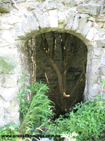
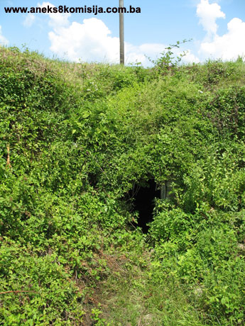
The Lower Fort is an artillery fortress of irregular rectangular plan, following the lie of the land. It was built on a relatively spacious and level plateau directly above the town of Srebrenica. The mountain slope on which the Lower Fort stands reaches into the fabric of the town. The fortress lies north-south with a deviation to the north-west/south-east. The wider sides of the fort are 80 m long, and the north side is 60 m long. It is 165 m in length. To this should be added the semicircular section of the north rampart, which projects outwards by about 10 m, so that the fortress occupies an area of about 12400 m2. Access to the fortress is from the east, at the south-east corner of the fortress right beside a pentagonal tower, or rather bastion. The fortress has three towers: one each at the south-east and south-west corners of the wall, and one at the north-west corner. The arrises of the towers are reinforced by finely-cut blocks of lighter-coloured stone than the stone used for the face of the towers and ramparts. The entire fortress was built of small pieces of roughly cut stone laid in courses. The ramparts were quite thick in places, particularly the south “strike wall,” where the casement was also located. The thickest, strongest and best fortified section of the ramparts was to the south, facing the čaršija. The cannon on the towers could be aimed at the entrance to the town of Srebrenica. Being built on sloping ground, the ramparts of the fort are as much as 5 metres in height on the outside, but can barely be made out in places from the inside. The best preserved tower is the one at the south-east corner, which is still standing to above the second storey. The fairly ruinous remains of yet another tower stand at the north-east corner. It is full of soil and covered with plant growth on the inside, but the revetment on the outside wall of the tower has survived in part. Within the fortress, there is a solidly-built chamber with a substantially-built vaulted ceiling by the south rampart. Premises of this kind are to be found in other fortresses built in Bosnia during the Ottoman period. There are no visible signs of any other buildings within the ramparts, although there must have been some, no doubt now hidden under layers of soil.
Two hundred metres below the fortress, on the lowermost slopes, is the White (Hajji Skender) Mosque, which constitutes an urban entity together with the fortress. It has been suggested that this was originally the Dubrovnik residents’ church of St Nicholas, built in the 14th century. I. Mujezinović recorded that parts of the nave of the church could be seen there, of which the sanctuary of the church was cut away and turned into the west front. The nave, as identified by Mujezinović, was rectangular in plan, 13 m long and 5 m wide, with two pilasters along the sides, merging into a pointed vault of Gothic style. The frame around the entrance doorway to the mosque dated from the Ottoman period in Bosnia and Herzegovina. A stone minaret was added to the left of the entrance. The mihrab was in the eastern half of the south-east wall. Vestiges of the pointed-arched windows, subsequently walled up, could be seen in the side walls. In 1935 the White Mosque was enlarged sideways, leaving the minaret in the middle of the frontispiece. The minaret was probably built by one Hajji Skender, after whom the mosque and the mahala around it were named. There is also a burial ground by the mosque, much of which has been exhumed; the remaining nišan tombstones with epitaphs were recorded by I. Mujezinović(14).
3. Legal status to date
The Regional Plan for BiH to 2000 listed Srebrenica (old fort, White Mosque, surviving old urban structure) as a Category II monument, under serial no. 20 in the list of the most important townscapes(15).
4. Research and conservation and restoration works
No major research works have been carried out. The remains of excavation can be seen in the north-east and the south parts, outside the casemate. No one in the field seemed to know who had done this or when.
In October and November 2006, on the initiative of the mayor of Srebrenica, Mirko Babić MA, with the intention of reviving the monument, an archaeologist carried out initial archaeological explorations within the ramparts of the fortress.
5. Current condition of the property
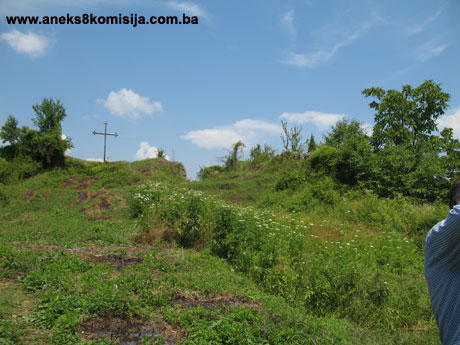
The property is in an extremely ruinous and neglected state. Much of the stone revetments of the ramparts are missing, and some of the contours of the fortress can barely be made out. An inspection of the site suggests that quantities of earth have been piled up on the plateau, particularly along the walls. This should be removed down to the original Ottoman stratum.
6. Specific risks
If the fortress continues to be left to the ravages of time, with no conservation works, it will fall still further into disrepair and ruin.
III – CONCLUSION
Applying the Criteria for the adoption of a decision on proclaiming an item of property a national monument (Official Gazette of BiH nos. 33/02 and 15/03), the Commission has enacted the Decision cited above.
The Decision was based on the following criteria:
A. Time frame (properties dating from prehistory to 1960)
B. Historical value (the building, group of buildings or site is associated with a historical figure or important historical event)
D. Clarity (documentary, scientific and educational value)
D.i. material evidence of a lesser known historical era
D.iv. evidence of a particular type, style or regional manner
E. Symbolic value
E.v. significance for the identity of a group of people
F. Townscape/ Landscape value
F.i. relation to other elements of the site
F.ii. meaning in the townscape
F.iii. the building or group of buildings is part of a group or site
G. Authenticity
G.v. location and setting
The following documents form an integral part of this Decision:
- Copy of cadastral plan;
- Copy of land register entry issued by the Municipal Court in Srebrenica;
- Photodocumentation (photographs taken on site on 13 July 2006).
Bibliography
During the procedure to designate the monument as a national monument of Bosnia and Herzegovina the following works were consulted:
1934. Dinić, Mihailo, “Srebrenik kraj Srebrenice” (Srebrenik nr. Srebrenica) GLAS SKA 161, Belgrade, 1934, 186-196
1952. Kreševljaković, Hamdija, “Prilozi povijesti bosanskih gradova pod turskom upravom,” Prilozi za orijentalnu filologiju i istoriju jugoslovenskih naroda pod turskom vladavinom (Contributions to the History of Bosnian Towns under Turkish Administration, Contributions for Oriental Philology and the History of the South Slavs under Turkish Governance), II/1951, Institute for Oriental Studies in Sarajevo, Sarajevo, 1952, 119-184.
1955. Dinić, Mihailo, Za istoriju rudarstva u srednjovekovnoj Srbiji i Bosni (For the history of mining in mediaeval Serbia and Bosnia) Part I, Serbian Academy of Arts and Science, special ed, bk. CCXL, Social Sciences Dept, bk. 14, Belgrade, 1955.
1978. Kovačević-Kojić, Desanka, Gradska naselja srednjovjekovne bosanske države (Urban Settlements of the Mediaeval Bosnian State), Sarajevo, 1978.
1979. Çelebi, Evliya, Putopis – odlomci o jugoslovenskim zemljama (Travelogue – Excerpts on Yugoslav lands), Sarajevo, 1979
1980. Various authors, Regional Plan for Bosnia and Herzegovina, phase B – valorization of natural, cultural and historical assets, Institute for Architecture and Town and Country Planning of the Faculty of Architecture in Sarajevo and the Planning Authority of Bosnia and Herzegovina in Sarajevo, Sarajevo, 1980
1982. Šabanović, Hazim, Bosanski pašaluk (The Bosnian pashaluk), Sarajevo, 1982.
1998. Mujezinović, Ismet, Islamska epigrafika Bosne i Hercegovine (Islamic epigraphics of BiH), Sarajevo: Sarajevo Publishing, 1998
(1) Kovačević-Kojić, Desanska, Gradska naselja srednjovjekovne bosanske države, Sarajevo: 1978, 32, n. 11-13 with other references.
(2) Kovačević-Kojić, Desanska, Ibidem, Sarajevo: 1978, 56, n. 7; Dinić, Mihailo, Za istoriju rudarstva u srednjovekovnoj Srbiji i Bosni, I deo, SAN, special ed., vol. CCXL, Social Sciences Dept, vol. 14, Belgrade, 1955, 96-97.
(3) Dinić, Mihailo, Ibidem, Belgrade, 1955, 58-59.
(4) Dinić, Mihailo, “Srebrenik kraj Srebrenice,” GLAS SKA 161, Belgrade 1934, 3.
(5) Dinić, Mihajlo, Ibidem, Belgrade, 1934, 186-187.
(6) Šabanović, Hazim, Bosanski pašaluk, Sarajevo, 1982, 51.
(7) Šabanović, Hazim, Ibidem, Sarajevo, 1982, 52-54.
(8) Šabanović, Hazim, Ibidem, Sarajevo, 1982, 168-169.
(9) Šabanović, Hazim, Ibidem, Sarajevo, 1982, 169.
(10) Kovačević-Kojić, Desanska, Ibidem, Sarajevo: 1978, 266, 270.
(11) Čelebi, Evlija, Putopis, odlomci o jugoslovenskim zemljama, Sarajevo, 1979, 99.
(12) Kreševljaković, Hamdija, “Prilozi povijesti bosanskih gradova pod turskom upravom,” Prilozi za orijentalnu filologiju i istoriju jugoslovenskih naroda pod turskom vladavinom, II/1951, 1952, 107.
(13) Kreševljaković, Hamdija, Ibidem, 1952, 123-124.
(14) Mujezinović, Ismet, Islamska epigrafika Bosne i Hercegovine, Sarajevo: Sarajevo-Publishing, 1998. 135, 136, 137.
(15) Various authors, Regional Plan for Bosnia and Herzegovina, phase B – valorization of natural, cultural and historical assets, Institute for Architecture and Town and Country Planning of the Faculty of Architecture in Sarajevo and the Planning Authority of Bosnia and Herzegovina in Sarajevo, Sarajevo, 1980, 56.
|