Status of monument -> National monument
Published in the “Official Gazette of BiH” no. 53/08.
Pursuant to Article V para. 4 Annex 8 of the General Framework Agreement for Peace in Bosnia and Herzegovina and Article 39 para. 1 of the Rules of Procedure of the Commission to Preserve National Monuments, at a session held from 4 to 11 September 2006 the Commission adopted a
D E C I S I O N
I
The archaeological site of the necropolis with stećak tombstones in Međugorje in Glumina, Municipality Neum is hereby designated as a National Monument of Bosnia and Herzegovina (hereinafter: the National Monument).
The National Monument consists of a mediaeval necropolis with 62 stećak tombstones.
The National Monument is located on a site designated as cadastral plot no. 2442 new survey, corresponding to c.p. no. e3654 andn 3660 (old survey), Land Register entry no. 130, cadastral municipality Gornje Hrasno, Municipality Neum, Federation of Bosnia and Herzegovina, Bosnia and Herzegovina.
The provisions relating to protection measures set forth by the Law on the Implementation of the Decisions of the Commission to Preserve National Monuments, established pursuant to Annex 8 of the General Framework Agreement for Peace in Bosnia and Herzegovina (Official Gazette of the Federation of BiH nos. 2/02, 27/02 and 6/04) shall apply to the National Monument.
II
The Government of the Federation of Bosnia and Herzegovina (hereinafter: the Government of the Federation) shall be responsible for ensuring and providing the legal, scientific, technical, administrative and financial measures necessary to protect, conserve and display the National Monument.
The Commission to Preserve National Monuments (hereinafter: the Commission) shall determine the technical requirements and secure the funds for preparing and setting up signboards with the basic data on the monument and the Decision to proclaim the property a National Monument.
III
To ensure the on-going protection of the National Monument on the area defined in Clause 1 para. 3 of this Decision the following protection measures are hereby stipulated.
- all works are prohibited other than research and conservation and restoration works, routine maintenance works, and works designed to display the monument, with the approval of the Federal Ministry responsible for regional planning (hereinafter: the relevant ministry) and under the expert supervision of the heritage protection authority of the Federation of Bosnia and Herzegovina (hereinafter: the heritage protection authority),
- the stećak (no. 1 in Bešlagić, Šefik, “Stećci u Gornjem Hrasnu”, Naše starine, VII, Sarajevo, 1960, 91-113), which has been moved to the churchyard of the Roman Catholic church in Hutovo, shall be restored to its original position, i.e. to its plinth which remains in situ,
- the site of the National Monument shall be open and accessible to the public, and may be used for educational and cultural purposes,
- works on the infrastructure are prohibited unless with the approval of the relevant ministry and subject to the expert opinion of the heritage protection authority,
- the dumping of waste is prohibited.
To ensure the on-going protection of the National Monument, a buffer zone is hereby stipulated consisting of a strip with a radius of 50 m around the boundaries of the protected site of the National Monument. The following protection measures shall apply in this zone:
- the construction of new properties or any other works that could have the effect of destroying the archaeological stratum or altering the appearance of the National Monument or the site are prohibited without a prior on-site inspection by a qualified archaeologist and the approval of the relevant ministry, under the expert supervision of the heritage protection authority,
- the dumping of waste is prohibited.
IV
All executive and area development planning acts not in accordance with the provisions of this Decision are hereby revoked.
V
Everyone, and in particular the competent authorities of the Federation of Bosnia and Herzegovina, the Canton, and urban and municipal authorities, shall refrain from any action that might damage the National Monument or jeopardize the preservation thereof.
VI
The Government of the Federation, the relevant Federal ministry, the Federation heritage protection authority, and the Municipal Authorities in charge of urban planning and land registry affairs, shall be notified of this Decision in order to carry out the measures stipulated in Articles II to V of this Decision, and the Authorized Municipal Court shall be notified for the purposes of registration in the Land Register.
VII
The elucidation and accompanying documentation form an integral part of this Decision, which may be viewed by interested parties on the premises or by accessing the website of the Commission (http://www.aneks8komisija.com.ba)
VIII
On the date of adoption of this Decision, the National Monument shall be deleted from the Provisional List of National Monuments of Bosnia and Herzegovina (Official Gazette of BiH no. 33/02, Official Gazette of Republika Srpska no. 79/02, Official Gazette of the Federation of BiH no. 59/02, and Official Gazette of Brčko District BiH no. 4/03), where it featured under serial no. 431.
IX
Pursuant to Art. V para 4 Annex 8 of the General Framework Agreement for Peace in Bosnia and Herzegovina, decisions of the Commission are final.
X
This Decision shall enter into force on the date of its adoption and shall be published in the Official Gazette of BiH.
This Decision has been adopted by the following members of the Commission: Zeynep Ahunbay, Amra Hadžimuhamedović, Dubravko Lovrenović, Ljiljana Ševo and Tina Wik.
No: 05.2-2-135/06-2
5 September 2006
Sarajevo
Chair of the Commission
Amra Hadžimuhamedović
E l u c i d a t i o n
I – INTRODUCTION
Pursuant to Article 2, paragraph 1 of the Law on the Implementation of the Decisions of the Commission to Preserve National Monuments, established pursuant to Annex 8 of the General Framework Agreement for Peace in Bosnia and Herzegovina, a “National Monument” is an item of public property proclaimed by the Commission to Preserve National Monuments to be a National Monument pursuant to Articles V and VI of Annex 8 of the General Framework Agreement for Peace in Bosnia and Herzegovina and property entered on the Provisional List of National Monuments of Bosnia and Herzegovina (Official Gazette of BiH no. 33/02) until the Commission reaches a final decision on its status, as to which there is no time limit and regardless of whether a petition for the property in question has been submitted or not.
The Commission to Preserve National Monuments issued a decision to add the archaeological ensemble of Neum-Glumina-necropolis of stećak tombstones to the Provisional List of National Monuments of BiH under serial no. 431.
Pursuant to the provisions of the law, the Commission proceeded to carry out the procedure for reaching a final decision to designate the Property as a National Monument, pursuant to Article V para. 4 of Annex 8 and Article 35 of the Rules of Procedure of the Commission to Preserve National Monuments.
II – PROCEDURE PRIOR TO DECISION
In the procedure preceding the adoption of a final decision to proclaim the property a national monument, the following documentation was inspected:
- Documentation on the location and current owner and user of the property (copy of cadastral plan and copy of land register entry);
- Data on the current condition and use of the property, including a description and photographs, data of war damage, data on restoration or other works on the property, etc.;
- Historical, architectural and other documentary material on the property, as set out in the bibliography forming part of this Decision.
The findings based on the review of the above documentation and the condition of the site are as follows:
1. Details of the property
Location
The village of Glumina lies in a karst valley wedged between hills. The village was formerly difficult to reach, but now that the road from Vratak reservoir to Glumina has been widened, access is easy. The road leads from the south, from the only natural open route, towards Hutovo and the Popovo plain.
The necropolis with stećak tombstones is about 1.5 km to the south-west of the village of Glumina and about 5.5 km from Hutovo. The Glumina road forks off after 4 km from the (Gornje) Hutovo – Velja Međa (Popovo plain) road, climbing from the Vratak reservoir to the village of Glumina. The necropolis of stećak tombstones is very close to the road about 1.5 km outside the village, on the level high ground known as Međugorje, between Mt. Kapa to the south and Mt. Treštenica to the north. The area where the necropolis is located is known by the locals as Polje (field or plain).
Historical information
There is a row of several prehistoric tumuli around the village, while the hill known as Gradina (hillfort) is immediately above the village. There are numerous buildings surrounded by dry stone walls at the base of Gradina. In the village itself is a well known by the locals as the “Greek well”, and an old burial ground with a small church and a necropolis with 5 or 6 stećak tombstones. Glumina formerly had a church dedicated to St Peter, which was destroyed by earthquake in 1667. These observations and the name of the village, rarely to be met in this part of the world, suggest that “the possibility should still be borne in mind that Constantine Porphyrogenitus' Galumainik was in the village of Glumina” (Anđelić, 1983, 46-47).
Glumina is one of a small group of villages with the collective name Gornje Hrasno. It is almost in the middle of Hrasno. In mediaeval times, Hrasno belonged to the Hum župa (county) of Žaba. The earliest record of this county is in the Chronicles of the Doclean priest, usually dated to the mid 12th century. Žaba county included Mt. Žaba, the long spine of which runs east-west from the western end of the Popovo plain to the delta of the river Neretva. The broad foothills of the mountain reach to the sea at the Pelješac (Ston) channel to the south and the Bregava and Krupa river basins to the north (Anđelić, 1983, 38). Until 1399, when the Republic of Dubrovnik purchased the New Lands from Bosnia’s King Dabiša, which were registered in the detailed land register of the Littoral (Republic of Dubrovnik) during King Ostoja’s reign, in 1405, the villages of Ošlje, Stupa, Topolo, Imotica, Štedro, present-day Klek, Gradina in Mala Neretva [where?] Brštanik town/fort was built in or around 1382, and the Slivno area belonged to Žaba county (Anđelić, 1983, 37, 39; Tošić, 1982, 49). Mt. Žaba divides the county into two equal halves: the northern continental area and the coastal area south of the mountain.
The relatively small kotar (district) of Hrasno is in the northern, continental part. This district was subdivided into small areas corresponding to the rural communities of Gornje and Donje Hrasno (now a small group of villages sharing the same name) or to a manorial estate that was probably in Hutovo (Anđelić, 1983, 40-42).
The territory of Žaba county coincided with the Nikolić’s feudal lands at the time of lord of the county Nikola (after 1327). Although Nikola formally held the title of lord of the county, he became the first feudal lord of Žaba county and vassel of Bosnia’s ban (governor) Stjepan II Kotromanić. The Nikolić’s were the leading landowning family in Žaba county and direct descendants of Hum’s Prince Andrija (1214-1217) who, at the time of the break-up of the Hum state in the early 13th century, held Popovo, the Littoral and Žaba. The Nikolić’s family burial ground, and probably their headquarters too, was in Vranjevo village. Their family tree can be traced over eight generations, right through to vojvoda (duke) Vukačin (1436-1453). The status of the family altered with the passage of time. At times they were direct vassals of the Bosnian king, but they were more often vassals of the Sanković’s in Popovo and the Kosača’s. The landowning clan of the Šimraks or Šimraković’s are known of in Žaba county in the 15th and 16th centuries (Dinić, 1967, 15). There are also scraps of information about other figures, stewards of the Nikolić feudal lords, in this mediaeval county (Anđelić, 1983, 37-38, 42).
The earliest sources pertaining to the Vlah organization in this region date from the early Ottoman period. The villages of Svitava and Hrasno are known to have belonged to the dukedom of Donji (Lower) Vlah, which also took in the Vlah communities in the environs of Stolac and Ljubinje (Ubosko, the Burmazi Vlahs). The Herzegovina sanjak was established in early 1470, but a year earlier the first census of the vilayet of Herzeg, the Herceg’s land, had been conducted. The sanjak was divided into three vilayets. At first, the area between the Neretva, Tara and Piva rivers, belonged to the Blagaj vilayet and kadiluk, and then to the large Drina kadiluk with its headquarters in Foča. Documents dating from 1473 and 1500 refer to the Primorje (Littoral) vilayet, extending from Gabela to Dračevica, which would mean that it also included the former mediaeval Žaba county (Šabanović, 1982, 156-159,161, 1967; Anđelić, 1983, 43).
2. Description of the property
The necropolis, which measures approx. 80 x 50 m, covers an area of approx. 4,000 m2, together with two tumuli, the larger of which is to the east of the road. The necropolis contains 62 tombstones, 18 of which are slabs, 39 chest-shaped and 5 ridge-shaped (gabled). Hard limestone was used to make the stećak tombstones, which are of very good workmanship and are well preserved. They lie in north-south rows, and face west-east. Fourteen of them are decorated.
No. 1 - Ridge-shaped with separate plinth, measuring: ridge-shaped 1.55 x 0.70 (0.63) x 1 m (of which the height of the “chest” is 0.8 m); plinth 1.92 x 1.20 x 0.3 m. Good workmanship and well preserved. At the base of the roof panes is a moulded rope-twist which also crosses the narrow ends; below this a frieze of twining vines with trefoils runs around all four sides. The upper surface of the plinth has a carved frame consisting of two parallel lines with the space between them filled by diagonal parallel lines.
Fifty years ago, during a visit to the necropolis, it was noted that the stećak had partly slid from its plinth. In the 1990s the ridge-shaped part was moved to the churchyard in Hutovo, leaving the plinth in situ.
No. 2 - Chest-shaped with plinth, measuring chest-shaped 1.26 (1.1 length at the base) x 0.50 x 0.66 m; plinth 1.56 x 0.8 x 0.18 m. Good workmanship. The tombstone is badly chipped on the west side. The east side is decorated in bas relief.
No. 3 - Chest-shaped, measuring 1.95 x 1.32 (1.16) x 0.48 m. Average workmanship. The top surface bears a longitudinal incised line, with a watermill symmetrically placed to the north and south of it.
No. 4 - Ridge-shaped (overturned), measuring 1.46 x 0.46 x 0.9 m (of which the height of the “chest” is 0.7 m). In or around 1960 Bešlagić noted that the tombstone was overturned. At the base of the roof panes is a moulded rope-twist which also crosses the narrow ends; below this a frieze of twining vines with trefoils runs around all four sides.
No. 5 - Chest-shaped on plinth, measuring chest 1.4 x 0.5 x 0.5 m; plinth sunk into the ground. Average workmanship. A Greek cross is carved into the top surface.
No. 6 - Chest-shaped, measuring 1.8 x 0.9 x 0.63 m. Good workmanship. All the edges are decorated with a moulded rope-twist.
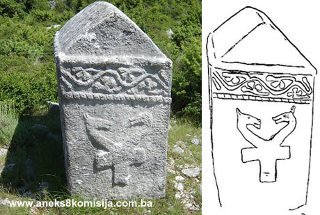
No. 7 - Ridge-shaped, measuring 1.64x 0.7 (0.6) x 1.14 m (of which the height of the “chest” is 0.88 m). Well cut and preserved. A moulded rope-twist runs along the base of the roof panes and the top of the narrow ends, and also decorates the edges of the tombstone. Below the top rope-twist is a frieze of twining vines with trefoils and added small decorations. The north side is decorated with a deer-hunting scene in bas relief, and the south side with a hunting scene with hunters on horseback, holding spears aimed at a deer. The spears are incised. The hunters are wearing caps resembling plumed helmets. Between the hunters is a deer being attacked by two dogs. The west end bears a motif of two dragons with serpent-like bodies regularly and symmetrically coiled and intertwined, equine heads, and wings. The tombstone is slightly sunken, concealing the ends of the dragons’ bodies.
No. 8 - Chest-shaped, measuring chest-shaped 1.55 x 0.72 (0.6) x 0.7 m; plinth 1.82 x 0.9 x 0.15 m. Well cut, but with narrow cracks on the longer sides. All the edges are decorated with moulded rope-twist.
No. 9 - Ridge-shaped, measuring 1.85 x 0.7 x 1.36 m (of which the height of the “chest” is 1.05 m). Where the roof panes meet the sides is a moulded rope-twist, below which the sides are decorated with a frieze of twining vines with trefoils, edged on the underside with rope-twist. The south side bears a deer-hunting scene in bas-relief, of which the central figure is a deer being attacked by two dogs on leashes held by horsemen. The hunter to the west is holding a sword and the one to the ease has a cap resembling a plumed helmet. The west end bears a bas-relief motif similar to the one on the west end of tombstone no. 7, where the dragons also have equine heads, but their bodies are joined. At the point where the bodies meet are two short horizontal wings which, with an extension below the join, form a kind of T-cross.
No. 10 - Ridge-shaped, measuring 1.68 x 0.68 (0.63) x 1.2 (of which the height of the “chest” is 0.83 m). Good workmanship, broken off at the edges in places. At the base of the roof and the narrow ends is a rope-twist motif. The west gable is decorated with a stylized vine branching out from a central branch along both sides of the gable. A perpendicular rope-twist runs down from the frieze of twining vines. The tops of the remaining sides are decorated with a frieze of twining vines, but without a rope-twist frame.
No. 11 - Chest-shaped, measuring 1.61 x 0.59 x 0.61 m. All the edges are decorated with a moulded rope-twist.
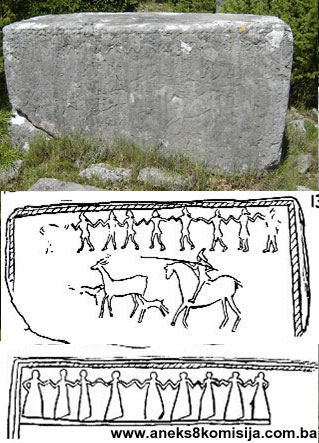
No. 12 - Chest-shaped, measuring 1.8 x 0.67 x 0.94 m. Good workmanship, but cracked in two places: a large crack on the lower western part of the stećak, and a narrow one in the middle of the upper part on both sides of the tombstone. The top of the north side is decorated with a motif of a kolo (round dance) with nine female figures, executed in a combination of engraving and bas-relief. The figures form a single line, equidistant from one another, and depicted in the same way: rounded heads, arms slightly raised, and long dresses flaring out at the base. Below and above the kolo is a narrow rope-twist giving the scene the impression of forming a frieze. A bas-relief rope-twist framed by engraved lines runs down the vertical edges of this side. The top of the south side is also decorated with a kolo, this time a men’s round dance, with the nine figures again indicated schematically. Their arms are raised to shoulder-height, and they have pointed caps, tightly belted waists, and short tunics flaring out at the bottom. All the dancers’ feet are pointing the same way. The dancers are moving to the right. The bottom half of this side has a hunting scene in bas relief with a hunter on horseback, aiming his spear at a deer with a dog running after it. The east end bears a design of a shield with a sword below it; the top of the shield is slanting, and has a slit for a spear. A moulded diagonal band runs across the shield. The west end bears the engraved figure of a deer.
No. 13 - Chest-shaped with plinth, measuring 1.35 x 0.62 x 0.59 m; plinth 1.55 x 0.72 x 0.16 m. Good workmanship and well preserved. The top of the sides is decorated with a moulded rope-twist.
No. 14 - Chest-shaped on plinth, measuring 1.4 x 0.75 (0.7) x 1.25 m; plinth 1.85 x 1.45 x 0.15 m. Good workmanship and well preserved. Decorated on all sides with engraved motifs. The top of the sides is decorated with a frieze composed of engraved four-petalled flowers or rosettes with rhomboid petals, two horizontal and two vertical; between the rosettes is a single horizontal petal of the same shape. The north side is decorated with four animals: a deer, two does behind it, and a fourth figure behind these; it is hard to make out what kind of animal this fourth figure might be. There is a bow and arrow and an unidentifed motif above the second doe. The south side has a hunting scene of a hunter on horseback hunting a doe. The east end of the tombstone bears a motif composed of a cross with circular garlands at the ends of the arms; a bird stands on the end of each of the cross arms. The west end is engraved with the same motif; below it is a rectangular shield with parts of a sword emerging below it.
There is a group of five stećak tombstones, three slabs and two chest-shaped, on a broken-up stone tumulus. All that remains of the tumulus is the basal stone surround enclosing an area with a diameter of 6 m. Another large tumulus, with a diameter of 12 m and a height of 3.5 m, is located on the opposite side of the Glumina road.
3. Legal status to date
The property is on the Provisional List of National Monuments of the Commission to Preserve National Monuments under the heading Neum-Glumina necropolis with stećak tombstones, under serial no. 431.
The Regional Plan for BiH to 2000 listed the stećak tombstones in the Čapljina area as category III monuments.
4. Research and conservation and restoration works
The necropolis was visited and described by Šefik Bešlagić in the early 1960s (Bešlagić, 1960, 101-106).
5. Current condition of the property
During an on site inspection on 21 July 2006 it was found that many of the tombstones have sunk into the ground or been shifted, and are overgrown with scrub. The stone from which they were cut is subject to damage and disintegration caused by exposure to the elements.
6. Specific risks
- natural factors: disintegration of the stone,
- lack of maintenance: rank overgrowth.
III – CONCLUSION
Applying the Criteria for the adoption of a decision on proclaiming an item of property a national monument (Official Gazette of BiH nos. 33/02 and 15/03), the Commission has enacted the Decision cited above.
The Decision was based on the following criteria:
A. Time frame
B. Historical value
C. Artistic and aesthetic value
C.iv. composition
C.v. value of details
G. Authenticity
G.i. form and design
G.v. location and setting
H. Rarity and representativity
H.i. unique or rare example of a certain type or style
The following documents form an integral part of this Decision:
- Copy of cadastral plan,
- Copy of land register entry,
- Plan of positions of stećak tombstones 1:500 (Bešlagić, 1960, 102),
- Photodocumentation:
- 31 photographs taken by the Commission on site July 2006,
- 10 photographs by Š. Bešlagić (Bešlagić, 1960),
- 11 drawings from book by M. Wenzel. (Wenzel, 1964)
Bibliography
During the procedure to designate the monument as a national monument of Bosnia and Herzegovina the following works were consulted:
1957. Vego, Marko, Naselja srednjovjekovne bosanske države (Settlements of the mediaeval Bosnian state), Sarajevo, 1957.
1960. Bešlagić, Šefik, “Stećci u Gornjem Hrasnu” (Stećak tombstones in Gornje Hrasno), Naše starine, VII, Sarajevo, 1960, 91-113.
1964. Wenzel, Marian, Ukrasni motivi na stećcima (Decorative motifs on stećak tombstones), Veselin Masleša, Sarajevo, 1964.
1971. Bešlagić, Šefik, Stećci, kataloško-topografski pregled (Stećak tombstones, a catalogue and topographical survey), Veselin Masleša, Sarajevo, 1971.
1982. Bešlagić, Šefik, Stećci. Kultura i umjetnost (Stećak tombstones – culture and art), Veselin Masleša, Sarajevo, 1982.
1982. Tošić, Đuro, “Donji tok Neretve u srednjem vijeku s posebnim osvrtom na trg Drijeva” (Lower reaches of the Neretva in mediaeval times with particular reference to Drijeva market), Hercegovina, periodical for culture and the historical heritage, no. 2, Mostar, 1982, 45-78.
1983. Anđelić, Pavao, “Srednjovjekovna humska župa Žaba” (Žaba Mediaeval County of Hum) Hercegovina, 3, Mostar, 1983, 35-56.
|