Status of monument -> National monument
Published in the “Official Gazette of BiH” no. 18/09.
Pursuant to Article V para. 4 Annex 8 of the General Framework Agreement for Peace in Bosnia and Herzegovina and Article 39 para. 1 of the Rules of Procedure of the Commission to Preserve National Monuments, at a session held from 16 to 22 May 2006 the Commission adopted a
D E C I S I O N
I
The historic site of the necropolis with stećak tombstones on the site of the Kaursko burial ground in (Ciklice) and Brdo in Vrbljani, Konjic Municipality, is hereby designated as a National Monument of Bosnia and Herzegovina (hereinafter: the National Monument).
The National Monument consists of a necropolis with stećak tombstones of the Kaursko burial ground with about 200 tombstones and the necropolis with stećak tombstones in Brdo with 4 tombstones.
The National Monument is located on a site designated as cadastral plot no. 1143, Land Register entry no. KKU 192/02, and c.p. no. 1553/1, Land Register entry no. KKU 2002/02, cadastral municipality Podorašac, Konjic Municipality, Federation of Bosnia and Herzegovina, Bosnia and Herzegovina.
The provisions relating to protection measures set forth by the Law on the Implementation of the Decisions of the Commission to Preserve National Monuments, established pursuant to Annex 8 of the General Framework Agreement for Peace in Bosnia and Herzegovina (Official Gazette of the Federation of BiH nos. 2/02, 27/02 and 6/04) shall apply to the National Monument.
II
The Government of the Federation of Bosnia and Herzegovina (hereinafter: the Government of the Federation) shall be responsible for ensuring and providing the legal, scientific, technical, administrative and financial measures necessary to protect, conserve, and display the National Monument.
The Commission to Preserve National Monuments (hereinafter: the Commission) shall determine the technical requirements and secure the funds for preparing and setting up signboards with the basic data on the monument and the Decision to proclaim the property a National Monument.
III
To ensure the on-going protection of the National Monument, the following measures are hereby stipulated.
Protection Zone I consists of the area defined in Clause 1 para. 3 of this Decision. The following protection measures shall apply in this zone:
- all works are prohibited with the exception of research, conservation and restoration works, routine maintenance works, and works designed to present the monument, pursuant to approval from the Federation ministry responsible for regional planning (hereinafter: the relevant ministry) and with the expert supervision of the heritage protection authority of the Federation of Bosnia and Herzegovina (hereinafter: the heritage protection authority),
- the site shall be open and accessible to the public, and may be used for educational and cultural purposes;
- infrastructural works or the building of full-profile roads are permitted solely with the approval of the relevant ministry and the expert opinion of the heritage protection authority;
- the dumping of waste is prohibited.
Protection Zone II consists of a strip 50 m wide around the borders of the defined site to the south, and 100 m wide on the other sides.
In this zone the following protection measures shall apply:
- the construction of buildings or facilities that during construction or operation could be detrimental to the National Monument is prohibited,
- the dumping of waste is prohibited.
The Government of the Federation is required in particular to provide for:
- making good cracked and broken stećak tombstones
- drawing up and implementing a programme for the presentation of the National Monument
IV
All executive and area development planning acts not in accordance with the provisions of this Decision are hereby revoked.
V
Everyone, and in particular the competent authorities of the Federation of Bosnia and Herzegovina and urban and municipal authorities, shall refrain from any action that might damage the National Monument or jeopardize the preservation thereof.
VI
The Government of the Federation, the relevant ministry, the heritage protection authority, and the Municipal Authorities in charge of urban planning and land registry affairs, shall be notified of this Decision in order to carry out the measures stipulated in Articles II to V of this Decision, and the Authorized Municipal Court shall be notified for the purposes of registration in the Land Register.
VII
The elucidation and accompanying documentation form an integral part of this Decision, which may be viewed by interested parties on the premises or by accessing the website of the Commission (http://www.aneks8komisija.com.ba)
VIII
Pursuant to Art. V para 4 Annex 8 of the General Framework Agreement for Peace in Bosnia and Herzegovina, decisions of the Commission are final.
IX
This Decision shall enter into force on the date of its adoption and shall be published in the Official Gazette of BiH.
This Decision has been adopted by the following members of the Commission: Zeynep Ahunbay, Amra Hadžimuhamedović, Dubravko Lovrenović, Ljiljana Ševo and Tina Wik.
No:05.2-2-221/05-2
17 May 2006
Sarajevo
Chair of the Commission
Amra Hadžimuhamedović
E l u c i d a t i o n
I – INTRODUCTION
Pursuant to Article 2, paragraph 1 of the Law on the Implementation of the Decisions of the Commission to Preserve National Monuments, established pursuant to Annex 8 of the General Framework Agreement for Peace in Bosnia and Herzegovina, a “National Monument” is an item of public property proclaimed by the Commission to Preserve National Monuments to be a National Monument pursuant to Articles V and VI of Annex 8 of the General Framework Agreement for Peace in Bosnia and Herzegovina and property entered on the Provisional List of National Monuments of Bosnia and Herzegovina (Official Gazette of BiH no. 33/02) until the Commission reaches a final decision on its status, as to which there is no time limit and regardless of whether a petition for the property in question has been submitted or not.
On 13 October 2004 the Office of Economic, Financial and Social Affairs of Konjic Municipality submitted a proposal/petition to designate the historic site of the necropolis with stećak tombstones on the site of the Kaursko burial ground in Vrbljani as a national monument of Bosnia and Herzegovina.
Pursuant to the provisions of the law, the Commission proceeded to carry out the procedure for reaching a final decision to designate the Property as a National Monument, pursuant to Article V of Annex 8 and Article 35 of the Rules of Procedure of the Commission to Preserve National Monuments.
II – PROCEDURE PRIOR TO DECISION
In the procedure preceding the adoption of a final decision to proclaim the property a national monument, the following documentation was inspected:
- Documentation on the location and current owner and user of the property (copy of cadastral plan and copy of land registry entry);
- Data on the current condition and use of the property, including a description and photographs, data of war damage, data on restoration or other works on the property, etc.;
- Historical, architectural and other documentary material on the property.
The findings based on the review of the above documentation and the condition of the site are as follows:
1. Details of the property
Location
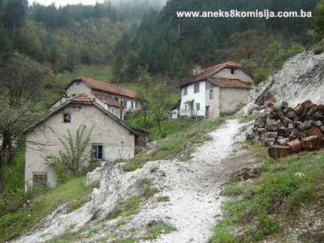
The village of Vrbljani is about nine kilometres to the north of Konjic. A road forks off westwards from the Konjic-Bradina road at km. 6 from Konjic, in Podorašac – this side road leads to the mountain village of Vrbljani, which is below the summit of Kosnik, about 2.5 km from Podorašac. Close to the endmost house in the village to the north, along the road to the village of Bali, one comes first to Brdo, where there is a small necropolis with 5 stećak tombstones. About 200 km further north is the Kaursko burial ground with about 200 stećak tombstones, extending between the old and the new road to the village of Bali.
Historical information
The village of Vrbljani is in the valley of the river Trešanica, on the hills above the right, west bank of the river. Thus far no signs of settlement dating from prehistoric times have been found in the environs of the village. Part of a milestone dating from antiquity has been found in the Kaursko burial ground. Although it may be in a secondary position here, this milestone is evidence that the road linking southern Dalmatia and Herzegovina with central Bosnia and the Danube basin ran here. This road ran from Narona (Vid near Mektović), via Dubravo and the Nevesinje plain to Velika poljana near Lipe. From Lipe to Podorašac and on northwards to Ivan-planina, the route of the Roman road and that of the later road dating from the Ottoman period are the same. This section of the road, from Konjic and Podorašac, led towards Zukići and on via Velike, one branch leading to the Ivan-planina pass and the other via Bitovnja in the mining basin around Kreševo and Fojnica (Anđelić, 1957, 169). According to the discovery of the milestones at Podorašac, the road was built in the 1st century CE and repaired in the 3rd century CE. In addition to these milestones, the well-preserved remains of an artificially built-up road were found on this stretch of road from Podorašac to Zukići (Anđelić, 1975, 57). In the pre-Roman and Roman period, the upper reaches of the Neretva were occupied by members of the Illyrian tribe of the Nare(n)si (Neretljani) with their political centre in the wider Konjic area on the right bank of the Neretva (Bojanovski, 1988, 133-140).
As regards the wider area, Vrbljani is in a district that composes a distinct entity extending from the Rakitnica gorge to the east to the river Kraljušnica to the west. In the late mediaeval period, the political centre of this region was in the fortified town of Črešnjevo (Trešnjevac), which was in the area above the left bank of the Trešanica, in the triangle formed by the surrounding villages of Kaljina, Džepi and Brčani (Brđani). The fort covered an area of about six hectares on Velika and Mala gradina («large and small hillfort»), part of the massif of Mt. Brvačka. The small fort of Dragić near Džepi was located about 1.5 m to the south of the town of Češnjevo. Its history is intimately linked with that of Črešnjevo. In terms of area, Črešnjevo was one of the largest fortified towns in Bosnia and Herzegovina. Furthermore, judging from the improved masonry techniques and the thickness of the ramparts (up to 2 m), greater than in other forts, and from the the civilian settlement and church surrounded by ramparts, the town could have reached this level of development only in the 15th century. The citadel at the highest point of the town, on Velika gradina, could date from considerably earlier than this (Anđelić, 1975, 155). The areas along the right bank of the Neretva formed part of the Bosnian part of the župa (county) of Neretva, and from 1404 right through to the fall of the Bosnian state were «crown lands». In addition to the names of individual villages in the Trešanica valley, Šunji, Brčani, Bradina, Zukići, Podorašac, Vrbljani, Kanjina, Galjevo and Ovčari, the basin of this river bore the general name of Dragočaj. This was also the name of the džemat (congregation) in the Ottoman period; this belonged to the nahija (small administrative district) of Neretva, to the part that had belonged to the crown lands in the mediaeval period. At the end of spring 1463, in Sultan el-Fatih's campaign, the area of the counties of Neretva and Kom were conquered. A counterattack by herceg Stjepan Vukčić Kosača liberated the so-called Hum Herzegovina and the western part of the Bosnian Neretva, but the walled town of Črešnjevo and the varoš (town) of Nertva on the right bank of the river, i.e. the administrative district of the town of Črešnjevo, remained under Ottoman rule (Anđelić, 1957, 211; 1975, 151-155; 1982, 115-116).
In the area known as Dragočaj, there are necropolises with stećak tombstones Podorašac, Zukići, Brčani, Džepi, Hum, Kanjina, Bradina and Vrbljani, the last three of which are quite extensive. A tradition concerning the «Greek» church is associated with Bradina, Repovci and Džepi, while in Vrbljani, in addition to the necropolis in the Kaursko burial ground, there is a site known as «Crkvina» [implying the presence of a church]. There are two toponyms near Vrbljani with the word «ban» (governor) as their roof: Banica and Podbanica. Around Bali, a village to the north of Vrbljani, and around Vrbljani itself, toponyms have been identified suggesting mining activities: Rove, Gornje Rove, Kibela, Kale, Kil and Bliznica. The name Doganište recalls the old customs house.(1)
2. Description of the property
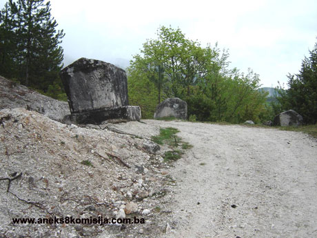
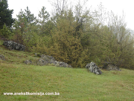
Close to the endmost house in the village to the north, along the road to the village of Bali, one comes first to the Brdo necropolis with four stećak tombstones. About 200 km further north is the necropolis of the Kaursko burial ground with about 200 stećak tombstones. In modern times, a new road was built as well as the old one leading to Bali. The entire complex consisting of the stećak tombstones in Brdo and some 200 stećak tombstones 200 m further north in Kaursko burial ground extends from north to west over a distance of about 1 kilometre, following the route of these roads. The tombstones are thus scattered about the surrounding meadows and clumps of treees alongside the road, in several rows running north-south. The necropolis occupies an area of about 4 dunums, i.e. about 4000 m2.
Necropolis with stećak tombstones in Brdo
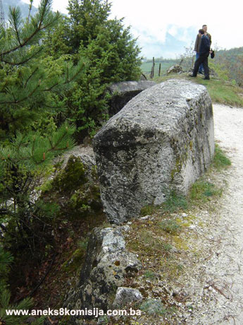
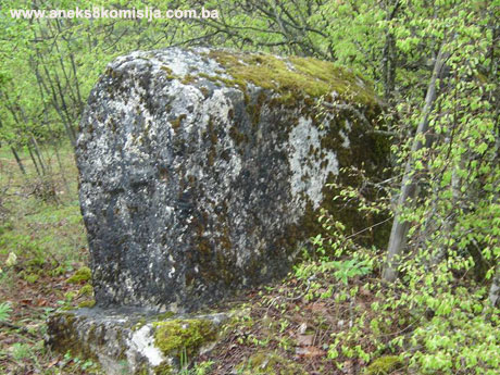
The Brdo necropolis has three ridge-shaped (gabled) tombstones, two with plinths, and one slab-shaped. The tombstones are of good workmanship, but the decorations are worn. Two of the gabled tombstones are decorated in bas-relief. All the stećak tombstones have been shifted from their original positions, which certainly took place before 1970, since Bešlagić refers to this in his book published in 1971 (Bešlagić, 1971, 326).
Stećak no. 1, ridge-shaped with plinth, cut from a single piece. Measurements: ridge-shaped 1.6 x 1.05 (0.90 at the bottom) x 115 m (of which the height of the gable is 0.2 m). The upper edge between the chest and the gable and the upper edge of the plinth are decorated with rope twist surrounding all four sizes. On the north face, the central motif is so badly worn that it is hard to make out, but gives the impression of a double spiral with two circular garlands above. Between the stems on which the spirals are set is a carved rosette and another two circular garlands. The south face has a double spiral with beside it a horseman on one side and a human figure with a staff on the other. The east side is carved with five round-arched arcades. There is a human figure, probably with a shield, in the second arcade as seen from the south.
Stećak no. 2, ridge-shaped with plinth, cut from a single piece. Measurements: ridge-shaped: 1.35 x 0.55 (0.45 at the bottom) x 0.7 m, (of which the height of the gable is 0.15 m); plinth 1.55 x 0.65 x 0.2 m. No decoration.
Stećak no. 3, ridge-shaped, measuring. 1.3 x 0.8 x 0.85 m (of which the height of the gable is 0.1 m). The north face bears a double spiral, and the west side a man with a shield and sword.
Stećak no. 4, slab-shaped, measuring 2 x 1.7 x 0.3 m. No decoration.
Necropolis with stećak tombstones in Kaursko groblje (Ciklice)
A necropolis with about 200 stećak tombstones lies 800 m away, extending from south to north, alongside the village road. Three of the tombstones are ridge-shaped, and the others are chest-shaped, slab-shaped or transitional in shape between chest and slab. Some of the tombstones are shaped from almost amorphous pieces of stone, and according to the literature, there is a piece of a Roman milestone and some fragments of antique architecture among the stećak tombstones (Bešlagić, 1971, 326).
The necropolis, and the stećak tombstones which are arranged in a number of rows from east to west, is north-south. The tombstones are fairly regularly arranged in rows.
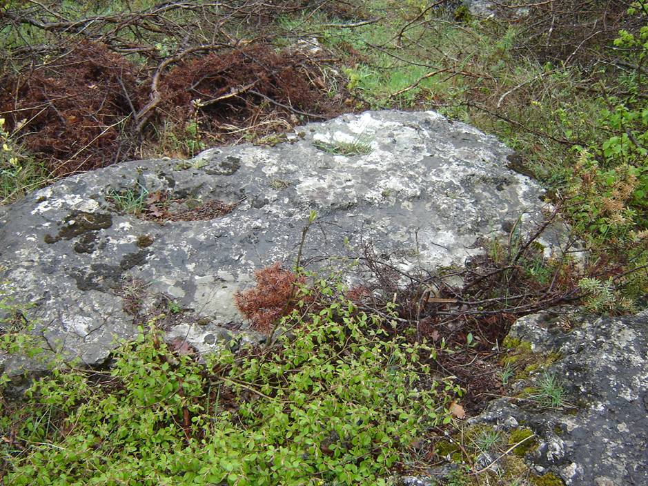
The workmanship of the stećak tombstones varies from well-cut to those of almost amorphous shape. They were cut from local stone, a soft limestone prone to splitting, as a result of which the workmanship is uneven and the degree of preservation is poor.
Six of the stećak tombstones are decorated (3 ridge-shaped, 2 chest-shaped and one slab). The tombstones with decorations are larger in size and of good workmanship. The decorations are in bas-relief. The decorative motifs are: standard-cut broad bands at the centre of the faces of the ridge-shaped tombstones, double spirals, rope twists, crescent moons, crosses and horses with riders.
Stećak no. 1, chest, measuring 2.2 x 1.30 x 0.5 m. The horizontal surface is divided by an incised line.
Stećak no. 2, chest, measuring 1.2 x 0.8 x 0.45 m. A horseman is carved in semi-relief in the centre of the side. There is a crescent moon above the head of the horseman in the upper corner. The lower half of both end faces of the tombstone has been destroyed.
Stećak no. 3, ridge-shaped with plinth. Measurements: ridge-shaped 1.50 x 0.60 x 0.75 (of which the ridge is 0.15 m in height) Plinth 1.9 x 1 x 0.25 m. The edge between the chest and the gable is surrounded by a rope twist. The end faces have double spirals by way of decoration.
Stećak no. 4, ridge-shaped with plinth, cut from a single piece. Measurements: ridge-shaped 1.7 x 0.7 x 0.75 m (of which the ridge is 0.15 m in height); plinth 2.1 x 1.1 x 0.10 m. Part of the plinth is covered in soil. At the centre of each end face is a thick carved vertical beam. Part around the corner of the gable is destroyed.
Stećak no. 5, slab, more than 2 m long, about 0.9 m wide. A large cross motif in semi-relief on the horizontal surface.
Stećak no. 6, ridge-shaped with plinth. Measurements: ridge-shaped:1.5 x 0.6 (0.5 at the bottom) x 0.9 m (of which the gable is 0.15 in height); plinth 1.9 x 0.9 x 0.2 m. Decorated on the upper half of the end face with a cross.
3. Legal status to date
The property is not on the Provisional List of National Monuments of the Commission to Preserve National Monuments; rather, the decision is adopted on the basis of the petition referred to above.
In the Regional Plan for BiH to 2000, the stećak tombstones of Konjic Municipality are listed as Category III monuments.
4. Research and conservation and restoration works
None.
5. Current condition of the property
An on site inspection conducted on 28 April 2006 ascertained that many of the tombstones are sunken and overgrown with shrubs, and that the local limestone of which they are made is prone to damage and deterioration from the effects of weathering. The stećak tombstones are covered with moss and lichen. In some places the decorations on the monuments can barely be made out. Many of the stećaks cannot be reached.
6. Specific risks to which the property is exposed
There are no specific risks, apart from natural factors.
III – CONCLUSION
Applying the Criteria for the adoption of a decision on proclaiming an item of property a national monument (Official Gazette of BiH nos. 33/02 and 15/03), the Commission has enacted the Decision cited above.
The Decision was based on the following criteria:
A. Time frame
B. Historical value
C. Artistic and aesthetic value
C.iv. composition
C.v. value of details
G. Authenticity
G.i. form and design
G.v. location and setting
The following documents form an integral part of this Decision:
- Copy of cadastral plan;
- Copy of land register entry;
- Drawings – plan of the necropolis dated 2006, drawn by the Konjic Municipality surveyor, Huso Bakić;
- Photo documentation of the Commission taken on site, April 2006.
Bibliography
During the procedure to designate the monument as a national monument of Bosnia and Herzegovina the following works were consulted:
1957. Anđelić, Pavao, “Turski put od Ivan-planine do Porima” (The Turkish route from Ivan-planina to Porimo), Naše starine, IV, Sarajevo, 1957, 169-179.
1958. Anđelić, Pavao, “Srednjevjekovni gradovi u Neretvi” (Mediaeval towns in the Neretva), Jnl of the National Museum in Sarajevo, new series, A, XIII, Sarajevo, 1958, 179-231.
1971. Bešlagić, Šefik, Stećci, kataloško-topografski pregled (Stećak tombstones, a catalogue and topographical survey), Sarajevo, 1971, 142-143.
1975. Anđelić, Pavao, Historjski spomenici Konjica i okoline, I (Historic monuments of Konjic and environs), Konjic Municipal Assembly, Konjic, 1975.
1982. Anđelić, Pavao, “Teritorijalno politička organizacija župe Neretve i njezino mjesto u širim političkim okvirima” (Territorial and political organization of the Neretva County and its place in the broader political context), In: Studije o teritorijalnopolitičkoj organizaciji srednjovjekovne Bosne (Studies on the territorial and political organization of mediaeval Bosnia), Sarajevo, 1982, 85-116.
1988. Bojanovski, Ivo, Bosna i Hercegovina u antičko doba (Bosnia and Herzegovina in antiquity), Academy of Sciences and Arts of Bosnia and Herzegovina, Works, bk. LXVI, Centre for Balkan Studies, bk. 6, Sarajevo, 1988.
(1) Zibela-seven parcelled-out parts of a mine field alloted to miners for use together with remuneration for the ore extracted (Skarić, Staro rudarsko pravo i tehnika (Old mining law and technique), Belgrade, 1939, 87); Kale-from the Turkish root Kal – to smelt ore; Kil- mining cramp; doganna- customs house.
|