Pursuant to Article V para. 4 Annex 8 of the General Framework Agreement for Peace in Bosnia and Herzegovina and Article 39 para. 1 of the Rules of Procedure of the Commission to Preserve National Monuments, at a session held from 19 to 23 January 2006 the Commission adopted a
D E C I S I O N
I
The historic site of the Čaršija in Foča is hereby designated as a National Monument of Bosnia and Herzegovina (hereinafter: the National Monument).
The protected area of the National Monumentconsists of the entire area of the Foča čaršija (Prijeka, Gornja and Donja čaršija) defined by the boundaries consisting of the following cadastral plots: from the upper bridge on the Ćehotina starting from c.p. nos.1704, 1703, 1712/1, 1712/2, 1713, 1717, 1634, 1631, 1630/1, 1635/1, 1636/1, 1604, 1587/2, 1587/1, 1585/1, 1582/1, 1581/1, 1583/2, 1583/1, 1748,1749, 1752, 1753, 1742, 1766, 1767, 1768, 1769, 3153, 3152, 3151, 3145/2, 3145/1, 1809, 1812, 1811, 1686, 1684, 1699, 1700, 1681/1, 1680, 1679 and 1676, to the upper bridge on the Ćehotina, cadastral municipality Foča, Municipality Foča, Republika Srpska, Bosnia and Herzegovina.
The provisions relating to protection and rehabilitation measures set forth by the Law on the Implementation of the Decisions of the Commission to Preserve National Monuments, established pursuant to Annex 8 of the General Framework Agreement for Peace in Bosnia and Herzegovina (Official Gazette of Republika Srpska no. 9/02) shall apply to the National Monument.
II
The Government of Republika Srpska shall be responsible for ensuring and providing the legal, scientific, technical, administrative and financial measures necessary to protect, conserve, display and rehabilitate the National Monument.
The Government of Republika Srpska shall be responsible for providing the resources needed to draw up and implement the necessary executive regional planning documentation for the National Monument.
The Commission to Preserve National Monuments (hereinafter: the Commission) shall determine the technical requirements and secure the funds for preparing and setting up signboards with the basic data on the monument and the Decision to proclaim the property a National Monument.
III
The Government of Republika Srpska shall be responsible for drawing up a detailed plan for the protection of the historic site of the Prijeka čaršija in Foča. The detailed protection plan shall pertain to the ensemble as a whole and to individual buildings within the protection area as defined in Clause 1 of this Decision.
Two protection levels shall apply to the protected area, as follows:
Protection Level I pertains to the cadastral plots specified in individual decisions of the Commission designating the following buildings or groups within the protected area as national monuments:
- Architectural ensemble of the mosque and medresa of Mehmed-pasha Kukavica – Decision no.: 06.1-02-1063/03-9. The National Monument stands on a site designated as c.p. nos. 1741, 1742 and 1766, c.m. Foča;
- site and remains of the architectural ensemble of the Careva (Emperor's) mosque (Sultan Beyazit Vali II mosque) – Decision no.: 06.2-2-1064/03-1. The National Monument stands on a site designated as c.p. no. 1787, c.m. Foča;
- site and remains of the Kadi Osman-effendi (Shaikh's) mosque in Foča – Decision no. 09-2-850/03-7. The National Monument stands on a site designated as c.p. no. 1703, c.m. Foča,
- historic monument of the Clock tower of Mehmed pasha Kukavica in Foča - Decision no. 07.1-02-280/05-4. The National Monument stands on a site comprising c.p. no. 1607, c.m. Foča,
- historic monument of the Han of Mehmed pasha Kukavica in Foča – Decision no. 07.1-2-275/05-8. The National Monument stands on a site designated as c.p. no. 1586, c.m. Foča.
The only interventions permitted on these sites are those designed solely for the protection and presentation of the properties. The specific protection regimes stipulated in the relevant Decisions of the Commission shall apply.
Protection Level II pertains to individual buildings and areas with value as monuments or of marked townscape/landscape value, located within the area specified in Clause 1 para. 2 of this Decision. In the area subject to this level of protection, all works are prohibited other than conservation and restoration works with the use of original materials and the full retention of the form of the buildings and spaces (horizontal and vertical dimensions, proportions, the number, size and disposition of doors and windows, architectural details and colour of walls, paving and treatment of facades). The following protection measurees shall apply to the site of Pazarišta (c.p. 1807, c.m. Foča), three surviving stone magazines (c.p. nos. 1722, 1793 and 1795, c.m. Foča), and the two best-preserved shops (c.p. nos. 1727 and 1732), as follows:
- area of Pazarišta – draw up a detailed town planning project which shall mandatorily retain the original use of the area as an open marketplace; works that conform to the provisions of the Programme for the Revitalization of the Prijeka čaršija in Foča and that pertain to the area of Pazarišta shall be permitted; the introduction of artisanal activities that include their simultaneous sale and of small-scale catering facilities may be provided for;
- the three stone magazines and two best-preserved shops – draw up a detailed plan for the restoration of the buildings: carry out conservation of the surviving original parts of the buildings and make good damage, subject to the mandatory retention of the authentic interior as far as possible; all interventions and methods used must respect all the typological and architectural characteristic of the building in question; all methods and extent of intervention applied must be recorded; the buildings shall be restored to their original use or to new non-destructive uses appropriate to the central urban zone – small-scale artisanal crafts, catering and service facilities.
No building, artisanal-cum-building or purely artisanal intervention provided for by the plan shall be carried out without the approval of the ministry responsible for regional planning in Republika Srpska (hereinafter: the relevant ministry) and under the expert supervision of the heritage protection authority of Republika Srpska (hereinafter: the heritage protection authority).
Protective level III consists of the area specified in Clause 1 para. 2 of this Decision that is not covered by protection levels I and II.
Within this protective strip, conservation and restoration measures that conform to the provisions of the Programme for the Revitalization of the Prijeka čaršija in Foča (adopted by Decision of the Municipal Assembly of Foča in 1984, Official Gazette of Foča Municipality no. 3/1984) shall apply to the buildings and interventions in the area that date from before 1990. In the case of all buildings and interventions dating from since 1990 that are in breach of or do not conform to the said Programme, the detailed conditions for each individual case must be determined:
- repair, conservation, making good and presentation of existing buildings and groups with architectural or townscape value;
- restoration and reconstruction of historic buildings, forms and spaces in order to ensure the integrity of the historic site and the idenfiability of its specific features (reconstruction of destroyed buildings, restoration of buildings or individual architectural features – horizontal and vertical dimensions, proportions, the number, size and disposition of doors and windows, architectural details, paving, the form, pitch and type of cladding of the roofs, the treatment of facades etc.);
- clearance and removal of extensions and additions to buildings or of entire buildings not in conformity with the townscape; alter individual elements of buildings arising from later interventions (removal of balconies and patios, replace picture windows/shop windows at ground-floor level with smaller ones);
- regulation of the size and disposition of doors and windows, replace iron, aluminium and plastic frames with wooden ones, respecting traditional designs and colour-schemes;
- all planned interpolated buildings must respect the building line of adjoining buildings at ground and upper floor levels, be of a height that conforms to the surroundings and may not be detrimental in form to the specific features of the protected area;
- all methods used and extent of intervention must be identifiable, and shall be carried out solely on the basis of approved documentation;
Use of buildings:
- restore the ground floors of the buildings to their original use or introduce new non-destructive uses appropriate to the Foča čaršija – small-scale catering and service facilities, traditional crafts that do not pollute the environment, specialized trade, excluding uses the nature of which is contrary to the historic site, which could cause noise or environmental pollution, or require major alterations to the structure of buildings or groups;
Infrastructure and urban furniture:
- the introduction of modern sanitary and technical fittings in a manner that shall not affect the outward appearance of the buildings shall be permitted;
- pedestrian and motor vehicle traffic shall be regulated;
- the central pedestrian zone shall be made good by designing and installing street lighting and urban furniture that conform to the architectural and typological context of the zone in question so that they shall not be detrimental to the townscape value of the ensemble;
- light fittings must be appropriate to the townscape (lantern-style for street lighting, appropriate floodlighting for individual monuments and townscapes);
- the erection of billboards, advertisements and signs blocking the view of or detrimental to the townscape is prohibited;
- signs, advertisements and notice boards, as well as shop fronts, shall not exceed ground-floor height nor project beyond the building line, except in the case of eaves and roofs, which may project by a maximumof 1 m. Exterior frames should conform to the traditional design and materials (wood or painted metal). The use of plastic or unpainted steel or aluminium for this purpose is prohibited. The use of large-scale notice boards, fluorescent lighting and plastic notice boards is prohibited;
- the installation of temporary structures (kiosks, lean-tos, stands, garages and the like) is prohibited other than during works on sites to restore them to their final use pursuant to this Decision, in which case such temporary structures shall be used for purposes associated with the building site or the works being carried out, and shall be removed on completion of the works, but no later than three years after being erected if the works have not been completed by that time;
- existing high and low vegetation must be preserved. A project shall be drawn up for the greening and landscaping of public spaces, using indigenous plant species;
- the construction of major infrastructure works and of industrial buildings and facilities within the protect site is prohibited.
No construction, construction-cum-artisanal or artisanal intervention may be carried out without the approval of the relevant ministry and under the expert supervision of the heritage protection authority.
A protective strip is stipulated consisting of all the cadastral plots adjoining the protected area of the National Monument.
Within this protective strip the only interventions to be permitted are those that conform to the existing proportions and local features. This must entail:
- ensuring that existing structures are retained subject to restrictions to the number of storeys, size of the buildings, and use of materials that closely resemble the indigenous and traditional materials used within the protected area;
- draw up a project designed for the greening and landscaping of public spaces, using indigenous plant species;
- within the area subject to this level of protection, new construction is possible provided that the new buildings are not detrimental in size, appearance or other manner to the monumental, natural or townscape value of the remaining areas;
- the construction of potential environmental polluters, major infrastructure works and of industrial buildings and facilities is prohibited.
IV
All executive and area development planning acts not in accordance with the provisions of this Decision are hereby revoked.
V
Everyone, and in particular the competent authorities of Republika Srpska, and urban and municipal authorities, shall refrain from any action that might damage the National Monument or jeopardize the preservation and rehabilitation thereof.
VI
The Government of Republika Srpska, the relevant Ministry and the heritage protection authority, and the Municipal Authorities in charge of urban planning and land registry affairs, shall be notified of this Decision in order to carry out the measures stipulated in Articles II – V of this Decision, and the Authorized Municipal Court shall be notified for the purposes of registration in the Land Register.
VII
The elucidation and accompanying documentation form an integral part of this Decision, which may be viewed by interested parties on the premises or by accessing the website of the Commission (http://www.aneks8komisija.com.ba)
VIII
Pursuant to Art. V para 4 Annex 8 of the General Framework Agreement for Peace in Bosnia and Herzegovina, decisions of the Commission are final.
IX
This Decision shall enter into force on the date of its adoption and shall be published in the Official Gazette of BiH.
This Decision has been adopted by the following members of the Commission: Zeynep Ahunbay, Amra Hadžimuhamedović, Dubravko Lovrenović, Ljiljana Ševo and Tina Wik.
No 07.1-02-1066/03-4
20 January 2006
Sarajevo
Chair of the Commission
Dubravko Lovrenović
E l u c i d a t i o n
I – INTRODUCTION
Pursuant to Article 2, paragraph 1 of the Law on the Implementation of the Decisions of the Commission to Preserve National Monuments, established pursuant to Annex 8 of the General Framework Agreement for Peace in Bosnia and Herzegovina, a “National Monument” is an item of public property proclaimed by the Commission to Preserve National Monuments to be a National Monument pursuant to Articles V and VI of Annex 8 of the General Framework Agreement for Peace in Bosnia and Herzegovina and property entered on the Provisional List of National Monuments of Bosnia and Herzegovina (Official Gazette of BiH no. 33/02) until the Commission reaches a final decision on its status, as to which there is no time limit and regardless of whether a petition for the property in question has been submitted or not.
On 19 December 2003 the Majlis of the Islamic community of Foča submitted a request to designate the townscape of the Prijeka čaršija in Foča as a national monument.
Pursuant to the provisions of the law, the Commission proceeded to carry out the procedure for reaching a final decision to designate the Property as a National Monument, pursuant to Article V of Annex 8 and Article 35 of the Rules of Procedure of the Commission to Preserve National Monuments.
II – PROCEDURE PRIOR TO DECISION
In the procedure preceding the adoption of a final decision to proclaim the property a national monument, the following documentation was inspected:
- Data on the current condition and use of the property, including a description and photographs, data of war damage, data on restoration or other works on the property, etc.
- Copy of cadastral plan and copy of land registry entry
- Historical, architectural and other documentary material on the property, as set out in the bibliography forming part of this Decision.
The findings based on the review of the above documentation and the condition of the site are as follows:
1. Details of the property
Location
Foča Municipality is in the upper Drina valley, where the borders of Bosnia, Herzegovina and Montenegro meet,very close to Mt Zelengora. The town of Foča is at an average altitude of 385 m above sea level, on hilly ground at the point where the river Ćehotina flows into the Drina.
The central features that dictated the emergence of a town at this point were the natural features of the surrounding hills and the two rivers, Ćehotina and Drina. The vegetation that grows throughout the entire urban structure of Foča is also an inseparable part of the town. This unique natural and built structure distinguishes Foča from every other historic urban structure in Bosnia and Herzegovina.
The site occupied by the town, where the Ćehotina gorge ends and the river flows into the Drina, is the gravitational centre of the wider area, and a place where roads from several directions have met since ancient times.
Historical information
The inner Foča area has been inhabited since prehistoric times, while the urban settlement itself dates from the mediaeval period.
The origins and development of the mediaeval settlement of Hoča (Hotča)(1) were dictated above all by its geographical position on the two rivers, the Drina and the Ćehotina, and on the road that linked Dubrovnik(2) with the Moravian and Vardar valley and the central regions of the Balkan peninsula.
The route of the Dubrovnik road remained identifiable in the street network in Foča(3) in the Prijeka čaršija, in the area tangential to Pazarišta (Trgovišta), where mediaeval Hoča (Hotča) came into being (Redžić, 1983, pp. 317-343).
The mediaeval settlement of Hoča underwent various stages of development in building and layout, from the opening of a caravan staging post (platea) and a market place to an urban settlement. As a result of its natural position between two rivers, the town was unfortified, and just before it was conquered by the Turks it was ruled by the last feudal lord of Podrinje and Hum, Stjepan Kosača. As the final point on the road via Čemerno and Sutjeska, Foča was destined by its lcation to become a major market and caravan staging post, so that the people of Foča began to engage in trade, initially with merchants from Dubrovnik (Kovačević-Kojić, 1978, pp. 43-44), sending deliveries of animal produce and wax to Dubrovnik and importing fabrics to eastern Bosnia (Kovačević-Kojić, 1978, pp.193-194). The large quantity of imported fabric is evidence of the economic development of mediaeval Foča and of the needs and purchasing power of its inhabitants. The presence of merchants from Dubrovnik in Foča enhanced the importance of the place, which by the15th century had become the major trade centre of eastern Bosnia (Kovačević-Kojić, 1978, p. 202).
The Ottomans took Foča in 1465 (Redžić, 1983, p. 325).
Immediately upon the Ottoman conquest of Bosnia and Herzegovina, the country was divided into nahijas, which largely coincided with the mediaeval župas (counties); the first Ottoman administrative authorities in these various places and nahijas were vojvodas (military leaders, cf. Latin dux) and their deputies, known as ćehaje. For the first five years the conquered areas of Herzegovina were part of the Bosnian sandžak, and their vojvodas and subaše (mayors) were directly accountable to the sandžakbeg or governor, Gazi Isa-beg, whose residence was in Sarajevo.
In February 1470 Herzegovina was removed from the authority of the Bosnian sandžakbeg to constitute a separate sandžak, governed from then on by its own sandžakbegs. The first of these was Hamza-beg, to whom there is reference as early as the beginning of 1470, and who held the post until 1474. During his governorship, Foča became the political and administrative centre of Herzegovina. He also erected a mosque in Foča.
Foča remained the headquarters of the Herzegovina sandžak until 1572, with the exception of two short periods, 1522 to 1530, and1533, when the headquarters was temporarily moved to Mostar. In 1572 the headquarters of the Herzegovina sandžak was moved to Pljevlje, where it remained until 1763 when Herzegovina was merged by firman with the Bosnian sandžak. In 1833 Herzegovina again became independent of Bosnia, and was thenceforth ruled by imperial governers or valijas (valis) with the rank of pasha, headquartered in Mostar, until 1877 when it was again merged with the Bosnian eyalet.
Once Foča ceased to be the headquarters of the Herzegovina sandžak it became the centre of other administrative authorities – a muselim (district prefect), ajan (local official) and alajbeg (spahi commanderof a sandžak). The muselim headed the civilian authorities in the town and nahija, and was appointed by the vizier himself. The first known muselim of Foča was Hajji Mehmed-aga Šuvalija, whose name is mentioned in sources dating from 1782. The ajans were representatives of the town in the Ajan Council of the governor's court. From the 18th century to 1838, Foča was also the seat of an alajbeg, the commander of the spahis of part of Herzegovina.
Judicial authority was established in Foča alongside the administrative authorities. The first known reference to a kadija (qadi) in Foča dates from 1472. As one of the country's larger towns, Foča also had a mufti, an Islamic jurist who issued fatwas or written legal opinions on certain matters not covered in detail by Shari'ah law. The earliest reference to a muftiluk (area under the jurisdiction of a mufti) in Foča dates from the mid 17th century (Bejtić, 1956, pp. 30-32).
Foča's greatest expansion took place from the mid 15th to the end of the 16th century, when it was promoted from a kasaba or small town to a šeher or city, and a major administrative centre in Herzegovina (Redžić, 1983, p. 322).
The town did not expand concentrically by new building around mediaeval Hoča, but was built more or less to a plan, accommodating itself to the topographic and morphological conditions and the possibilities of building on both sides of the rivers. The construction of the first six mahalas(4) gave the urban area of Foča its basic form and dictated the further expansion of the settlement on both sides of the river Ćehotina and on the right bank of the Drina.
The fact that Foča was the headquarters of the Herzegovina sandžak had an impact on the development of the town from the urban, economic and cultural point of view, as well as the introduction of the infrastructure necessary to development a system of civilian authority and of religious, cultural, educational and commercial institutions. The construction of the Hasan Nazir (Aladža) mosque in the early 16th century marked the start of the most productive period of building in Foča. The town took on all the appearance and features of an «oriental» town.
Dubrovnik masons were also involved in erecting these buildings, as evidenced by numerous documents concerning their activities in BiH in the mediaeval period and throughout the entire Ottoman period, particularly in the 16th and first half of the 17th century. Renowned for their skill as masons, they were called upon to build monumental edifices, and in particular the more demanding structures of vaults, arches and domes, and the more sophisticated masonry work of a decorative nature on the bases and capitals of columns, stalactites and the like (Bejtić, 1952, p. 240).
During this period, it was not only architecture that developed: various crafts also evolved, notably the art of metalworking and of working in bone, wood and stone.
When Foča came under Ottoman rule, the economic nature of the town altered. There are references in the „Hasu Hoči“ and the 1477 Turkish census to vineyards in the Foča area, with a note of the tax to be charged on the production of wine. However, wine-making died out during the Ottoman period, and the population increasingly turned to an economy based on trade and crafts. Foča's economic development was particularly marked in the 16th century, especially in the final decades of the century. Most of the commercial buildings of that period were built by individuals in the form of endowments (vakufs). Vakufs registered later (in the early 17th century) reveal that in the early decades of that century Foča had at least 24 types of trades and crafts (cooks, barber-surgeons, bičakčije [knifesmiths], buzadžije [makers and purveyors of the grain-based drink boza], bootmakers, dunđeri [general mason-carpenters], wool-carders, coffee-house keepers, tinsmiths, butchers, haberdashers, blacksmiths, kujundžije [goldsmiths], potters, millers, mudželiti [bookbinders], nalbanti [farriers], pašmakčije [shoemakers], bakers, saddlers and harness-makers, tanners and leatherworkers, taščije [stonemasons], tailors, greengrocers, tudžari [merchants], customs officers and commission agents).
The leading trade was tanning and leatherworking, and tanners constituted the largest number of artisans. They had their own workshops on the southern outskirts of the town, which was known as Tabaci (tanners). There were also some other crafts of which no written evidence could be found, but which are known to have existed: well-diggers, tile-makers, adobe brick-makers, wool-carders, comb-makers, coppersmiths, mutapčije (makers of haircloth articles), pack-saddle makers and gunsmiths. Another distinct branch of the economy was the cottage industry, producing various types of cloth, embroidery and kilim rugs, for use in the home or for sale. The raw materials used were wool, cotton and silk; the latter is particularly worthy of mention in tht it was prodeuced in Foča itself, with many families raising silkworms, for which purpose they grew mulberry trees in their gardens and courtyards to feed the silkworms.
Trade and crafts in Foča had reached an advanced stage of development by the early 19th century, when the Dubrovnik road was closed following the fall of the Republic of Dubrovnik. Trade then began to be increasingly based on the interior, particularly on Serbia. The main items of trade continued to be wool, wax and leather. It was the general rule in Foča that trade was in the hands of the Orthodox population and crafts and artisanship in Muslim hands. Among the more prominent merchant families were the Glođaja, Hadživuković, Jakšić and Sunara families. It was then that Muslim families too began to engage in trade. The leading Muslim merchant families at that time were the Karahodže, Hanjalić, Njuhović, Bakić, Kahvedžić, Tuno and Kašmo families (Bejtić, 1956, pp. 36-38).
Little was written about Foča and its edifices, particularly during the 16th and 17th centuries. Most of what is known about the town at that time is to be found in the notes and reports of various travel chroniclers, prominent among them Benedetto Ramberti, Jean Chesneau, Melchior pl. Seydlitz, Philippe du Fresne-Canaye, and Lefevre, who provide important information about the appearance of the town at that time. One of the finest descriptions of Foča at that time is provided by Evliya Çelebi, who was in Foča in 1664.
According to Evliya Çelebi, Foča was «A šeher [sizeable town, city] conquered by Abu’l Fath, Sultan Mehmed Khan, in 869 AH [1465]. . . . It is now in the Herzegovina Herzegovina sandžak. It is governed by a vojvoda.
In Foča as a whole there are seventeen Islamic places of worship (mihrab). Prominent among them is the mosque of Sultan Beyazit Vali in the old čaršija. This is an old-fashioned mosque, solidly built in the old style. It has a wooden dome clad with lead, and one minaret. There are six medresas in Foča, in some of which Islamic tradition (hadith) is taught. There are eight tekkes. There are three public baths (hammams), a courtroom (mehkheme), a spacious musalla, and two public kitchens (imaret.» (Çelebi, 1996, pp. 403-410).
During the Austro-Hungarian period, Foča initially gained strategic importance, but its urban development stagnated. Stagnation, or even regression, also characterized building activity in Foča between the two world wars (various authors, 1983, p. 8).
Just before World War II, Foča was a small town with about 5,000 inhabitants. It began to develop further when the Ustiprača-Foča railway line was opened in 1939.
During World War II, Foča was laid waste and set on fire.
Once World War II was over, new, modern building began, which preserved within the urban fabric all the historic strata of construction from the mediaeval to the modern period,
In the 1992-1995 war in Bosnia and Herzegovina, the town suffered major vandalism and destruction.
2. Description of the property
Since Foča's greatest expansion was in the time of the Ottoman adninistration, from the second half of the15th to the end of the 16th century, and its čaršija is one of the most important features of the town, it constitutes its commercial centre, where the majority of its economic activity took place.
The historic centre of Foča, the Čaršija, is a cultural monument that emphasizes the cultural and historical character of the area and the way it has remained unaltered throughout its historical development. However, its greatest value is as a townscape – its spatial composition. The ensemble is characterized by a concentration of monumental buildings, and individual architectural accents of which the architectural value is not particularly great but the disposition of which is such as to make it possible to define the urban composition with precision.
The Foča čaršija as a whole consists of three parts: the Donja (Lower), Prijeka and Gornje (Upper) čaršijas, which constitute a single urban and architectural entity. For a better understanding of the influences that dictated the formation of the Foča čaršija, it is important to analyse a much wider area.
From its very origins, Foča evolved as a typical trade and artisanal town. In layout, it developed irregularly and freely, with its commercial area at the centre of the town and its residential quarters arrayed on the surrounding slopes, around narrow, winding streets.
In general urban layout the town is distinguished by two specific factors: the rivers Drina and Ćehotina, with their confluence in the town itself, thus dividing it into two almost independent entities. The third and central area is the hilly terrain that slopes down on three sides towards the two rivers. The layout of the town is entirely subordinate to these natural determinants. The central part of the town, between the two rivers, is the commercial area and administrative centre of the town, and is densely built up. The residential quarters that surround it are more thinly built up.
The entire architectural structure of the town is defined by its houses, which constitute the largest number of buildings, and the mosque complexes with their minarets soaring above the roofs of the surrounding buildings. The houses of Foča are, as a rule, two-storey buildings all of the same height, markedly horizontal in structure, a feature emphasized by their unusually low hipped roofs clad with brick-red hollow tiles. This typical structure and silhouette of the town is particularly visible where the Careva and Kukavica mosques are located in the čaršija. Both mosques stand on an elevation and constitute the spatial reference point of the town.
The historical evolution of the urban structure of the town of Foča can be traced stratum by stratum from the mediaeval period to the present day.
The centre of mediaeval Foča developed in the area surrounded by the Drina and the Ćehotina. This assumption is corroborated by the census of the Foča has, which notes in one passage concerning a plot of land on the right bank of the Ćehotina that it lies „towards Hoča“, suggesting that the varoš was beyond and opposite the area known to have extended along the right bank of the Ćehotina. The image of mediaeval Foča can be reconstructed as follows: a settlement on a gentle slope to the hillock on which the clock tower now stands, a square (Pazarište) on its south-eastern edge, and a church (now the Careva mosque) above the square, as the most prominent feature of the settlement. The development of the mediaeval settlement on this site was favoured by the gently undulating terrain, well suited to building and very close to running water (Bejtić, 1956, p. 43).
This was the area that was to become the nucleus of the town that evolved later, in the Ottoman period, and began to spread outwards. The Ottomans called this area Ortakol (the central area). It was here that the first and oldest mosque in Foča was built, with the first shops nearby, forming the basis of the future čaršija.
As in other settlements dating from the Ottoman period, there was a visible division – what would now be known as zoning – into the commercial and artisanal, business quarter and the residential quarters. Foča has retained this same layout to this dayl.
The Foča čaršija took shape not on level ground but on hilly terrain, along a broken line, indicating that it followed the line of the mediaeval transit route. The most important part of the čaršija was the market square or Pazarište, which lies below the Careva (Emperor's) mosque. This square essentially retained its mediaeval form. It is a large, irregular, radiating square on a site sloping down towards the Ćehotina, with seven surrounding streets converging on it from various parts of the town. Later it was to become a square where fairs were held, and later still a market place.
Details of the old Dubrovnik road indicate that it ran through the centre of the town, across the square, and steeply down to the Ćehotina. In the light of this, it may be assumed that there were a number of trading posts in the square in the mediaeval period, later to e transformed and extended in the Ottoman period with the erection of shops along the north and west sides. The continuation of the Foča čaršija took shape along the Dubrovnik road in both directions, thus forming three separate entities: the Prijeka, Upper and Lower čaršijas.
Prijeka, which has retained its name to this day, took shape on the street leading from the square north-west to the clock tower, where it forms an almost perfect right-angle to continue on to the south. This part of the čaršija, from the clock tower, is known as the Upper čaršija. Here, as well as shops, there were hans (hostels) and a caravansarai. In the extension of this street was an area called Dogana (Italian for customs house), suggesting that there were shops here too at one time, and that the upper čaršija formerly extended further southwards. The Lower čaršija extended along the street that descends steeply from the square towards the former wooden bridge over the Ćehotina by the Shaikh's mosque. This lower čaršija is sometimes referred to in documents as the Carska (Imperial) or Sultan čaršija. The steep section of the street between the square (Pazarišta) and Prijeka čaršija was known as Prazi (Pragovi), indicating that it once consisted of steps (Bejtić, 1956, p. 44).
There was once a fourth čaršija in Foča, in Donje Polje, in the Atik mosque mahala, alongside the transit road. However, this čaršija never greatly developed, since it was only used by the local inhabitants.
Some shops were built in Ortakol, leading from the square to the lower bridge over the Ćehotina. It is not known whether there were shops here in olden times, so it may be assumed that this part of the čaršija took shape later, when the new (lower) bridge over the Ćehotina was built, opening up this part of the town to traffic.
Given that at the time Foča developed into a town there were no carts or carriages, but everything was transported on foot or horseback, the streets were of a size appropriate to such traffic. All the streets are quite narrow, and undifferentiated in transverse profile into roadway and footpath. A study of the streets of Foča reveals that most of them took shape as passageways between the high courtyard walls separating the private, residential quarters from the public space of the street. Vestiges of cobbling visible here and there suggest that the streets of Foča were cobbled. Minor remnants of this can still be seen on the steep street known as Kačanik, leading down from the upper čaršija past the clock tower.(Bejtić, 1956, p. 48).
The relative economic stagnation of the historic centre in the Austro-Hungarian period until the end of World War II, and the aftermath of the recent war and post-war period, have been an obstacle rapid development of new buildings in the fabric of the čaršija. This is to some extent fortunate, since as a result it has managed to retain its layout.
Although the architectural and aesthetic value of individual buildings in this area is not great, nonetheless in concentration, spatial disposition, belonging to the same historical style as a product of the same period, and spatial relationships they have had an impact on forming the general image of a historic area.
The buildings in the Foča čaršija can be classified into several groups:
- edifices of monumental value (buildings of architectural-cum-artistic value and historical significance): the Careva mosque and burial ground, the Mehmed pasha Kukavica mosque and medresa, the Shaikh's mosque, the Han and the Clock tower, as well as the Pazarište (as the mediaeval area);
- buildings of considerable townscape value (with features constituting the most typical aspect of a certain townscape or the utmost expression of its authenticity): three surviving stone magazines, and the three best-preserved shops in the čaršija;
- buildings that do not belong to the style but that in proportions and siting are not detrimental to the identity of the area;
- the majority of more recent buildings have spoiled the townscape value of the historic fabric with their obtrusive and over-large size and use of new materials, jarring with the adjoining buildings. Similarly, later interventions to surviving older buildings have devalued them, so that they are out of harmony with the townscape (various authors, 1983, p. 11).
INDIVIDUAL BUILDINGS AND ARCHITECTURAL GROUPS OF VALUE AS MONUMENTS
Careva mosque (Sultan Beyazit Vali II mosque) in Foča
The Careva mosque is in Careva mahala in the very centre of the town of Foča, between the rivers Drina and Ćehotina, above the former open mediaeval square known as Pazarište. The Careva mosque (mosque of Sultan Beyazit Vali II, 1483-1512) belongs in ground plan to the single-space type of mosque with hipped roof and stone minaret.
The Careva mosque in Foča was set on fire and its minaret dynamited in April 1992.
More detailed information on this property may be found in the Decision designating the site and remains of the architectural ensemble of the Careva mosque (Sultan Beyazit Vali II mosque) in Foča as a national monument.
Mosque of Mehmed-pasha Kukavica
According to the tarih (chronogram) incised on a stone plaque set into the wall above the entrance, the Mehmed-pasha Kukavica mosque was built in 1165 AH (1751/1752) and was the last mosque to be built in Foča.
It belonged to the typological group of single-space domed mosques with open exterior portico.
The Mehmed-pasha Kukavica mosque was dynamited on 28 May 1992. The minaret was completely destroyed, the interior of the mosque was wrecked, the exterior portico with its sofas was entirely destroyed, and the medresa, abdesthana and muderiz' living quarters were set on fire and completely destroyed. The dome of the mosque finally collapsed in the autumn of 2002.
More detailed information on this property may be found in the Decision designating the architectural ensemble of the mosque and medresa of Mehmed-pasha Kukavica in Foča as a national monument.
Kadi Osman-effendi (Shaikh's) mosque
The Kadi Osman-effendi mosque, or Shaikh's mosque as it is known to the locals, is below Pazarište near the former lower čaršija close to the upper bridge over the Ćehotina. The building is one of the monuments that differs in architecture from the usual type of mosque in these parts: in ground plan it is wider than it is long. The entrance door was made of two pieces of hazel wood; there were two mihrabs, one inside and one outside, on the right-hand sofa; and the minaret stood to the left of the entrance to the mosque.
The inscription on the mosque, on a stone plaque measuring 35 x 78 cm set into the wall over the entrance to the mosque, gives the year when the mosque was built, 1002 AH (1593/94) (Mujezinović, 1998, p. 49).
The mosque was destroyed during the 1992-1995 war.
More detailed information on this building is to be found in the Decision designating the Site and remains of the historic monument of the Shaikh'smosque (Kadi Osman effendi's mosque) in Foča as a national monument.
Medresa of Hajji Mehmed-pasha Kukavica
This was the last medresa to be built in Foča, completed in 1758, and stood beside the founder's mosque in the upper čaršija, forming a wing to the left of the mosque courtyard the entire length of the street to the north-west as far as the mosque to the north-east. Before the Mehmed pasha medresa was built, there were at least two others in Foča, but both had fallen into disuse before the Kukavica medresa was built. The Mehmed pasha medresa, built immediately after his mosque, was at that time the only such institution in Foča.
More detailed information on this property may be found in the Decision designating the architectural ensemble of the mosque and medresa of Mehmed-pasha Kukavica in Foča as a national monument.
Caravansarai of Mehmed-pasha Kukavica
One of the few surviving buildings of this type in BiH is the caravansarai in Foča, built before 1758 by Mehmed-pasha Kukavica, an Ottoman feudal lord, native of the village of Popa in Sutjeska, with whose funds the nearby mosque and clock tower were also built (Finci, Taubman, 1954, p. 113).
This caravansarai, which was also known as the Great Han, is a typical example of the group of hans with no courtyard, of rectangular ground plan and very simple layout. The ground floor had ample stabling for horses, and to the left and right of the entrance a goods magazine where travellers could buy and sell. By the main entrance to the stables was a staircase leading to the central landing on the first floor, around which the bedrooms were arranged. On one of the narrower sides of the landing was a washroom and toilet area.
More detailed information on this building is to be found in the Decision designating the Historic monument of the Han of Mehmed pasha Kukavica in Foča as a national monument.
Clock tower of Mehmed-pasha Kukavica
The clock tower is in the immediate vicinity of the mosque and other endowments of Mehmed-pasha Kukavica in Foča. Since there is no written evidence of the erection of the building, the assumption is that it dates from after 1758, since there is no mention of it in Mehmed-pasha's vakufnama (deed of endowment) of that year. The clock tower was thus build later than that year, but prior to 1761, when Mehmed-pasha was expelled from Bosnia and executed (Bejtić, 1957, p.48).
More detailed information on this building is to be found in the Decision designating the Historic monument of the Clock tower of Mehmed pasha Kukavica in Foča as a national monument.
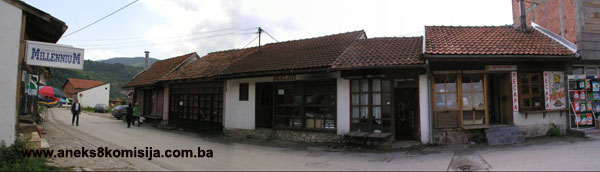
Čaršija – shops and magazine storerooms
Shops and storerooms were responsible for almost the entire economic activity of the čaršija. Shops were used for both the production and the sale of goods, while magazines were used mainly for storage, and only rarely for selling goods.
The Prijeka čaršija consists of an irregular range of small shop premises, built of light-weight materials, in spirit of the local tradition. The basic feature of all these shops is the clean, marked lines of their structure. All the movable and fixed, infill components were of wood, plastered only in the case of two-storey buildings.
The shops are small single-storey buildings, timber-built with a roof cladding of hollow tiles. They form rows on either side of the streets and were usually raised above street level. They were open to the street at the front, and were closed by two wooden shutters forming a bipartite ćepenak. The upper half was raised to hang below the eaves, and the lower half rested on a joist supported on brackets. When the shop was open the lower shutter was used for working and as a seat. All the shops were small in size, enabling everything to be within reach. People did not enter the shop; trade took place with people seated on the ćepenaks.
In stylistic features, the shops can be classified as:
- shops with vertically raised double ćepenak
- with no magazine
- with magazine
- with first-floor magazine
- [with magazine?] below the shop (or on the first floor)
- shops with horizontal sliding or folding shutters, European-style. These are at street level, and must be entered;
- solidly-built magazines, sometimes with vaulted ceiling;
- modern-style shops at street level, with entrance and shop windows. (Various authors, 1983, p. 12).
The magazines are more solid structures with stone walls, built to the model of the shops in Dubrovnik. The sales areas were in the ground floor, with the storerooms above. To protect them from burglars and fire, the windows were fitted with iron bars and shutters, and the doors were of wrought iron, mainly with a terminal moulding of a stone string course. The basic structural system consisted of thick stone walls with a ceiling of tufa, and ceiling joists of close-packed wooden beams with a thick coat of clay. The stairs were very narrow, 0.50 to 0.60 m, and a ladder was used to enter the basement and the top floor.
3. Legal status to date
By Ruling of the Institute for the Protection of Cultural Monuments and Natural Rarities o NR BiH, the following buildings were placed under state protection:
- Careva mosque in Foča, Ruling no. 1317/50 dated 9 October 1950
- Sultan Fatima grave in Foča, Ruling no. 1480/50 dated 28 October 1950
- Mehmed-pasha Kukavica mosque in Foča, Ruling no. 1312/50 dated 9 October 1950
By Ruling of the Institute for the Protection of Cultural Monuments and Natural Rarities o NR BiH no. 02-854-3 dated 18 April 1962, the Careva mosque in Foča with burial ground was entered on the register of immovable cultural monuments.
The Regional Plan for Bosnia and Herzegovina to 2002 listed the following properties:
- urban ensemble of Foča (the čaršija, 3 hans, the clock tower, two tombstones by the mosque, and a turbe) as a Category 1 monument,
- the Careva mosque as a Category 1 monument
- the Mehmed-pasha Kukavica mosque and clock tower in Foča as Category 2 monuments
- the Kukavica han and part of the Mehmed-pasha Kukavica medresa in Foča as Category 3 monuments.
The following properties are on the Provisional List of National Monuments of the Commission to Preserve National Monuments:
- the Careva mosque in Foča/Srbinje under serial number 213; designated on 14 June 2000
- the Mehmed-pasha Kukavica mosque in Foča/Srbinje under serial number 212, under the heading Remains of the Kukavica mosque, designated on 14 June 2000.
Thus far, the Commission to Preserve National Monuments has issued the following Decisions designating the properties as national monuments:
- the architectural ensemble of the mosque and medresa of Mehmed-pasha Kukavica, decision no.: 06.1-02-1063/03-9, designated at the 13th session held from 2 to 8 March 2004
- the site and remains of the architectural ensemble of the Careva mosque (Sultan Beyazit Vali II mosque), decision no. 06.2-2-1064/03-1, designated at the 15th session held from 6 to 10 July 2004
- the site and remains of the historic monument of the Shaikh's mosque (Kadi Osman effendi's mosque) in Foča, decision no. 09-02-850/03-7, designated at the 23rd session held on 8 to 14 November 2005
- the historic monument of the Clock tower of Mehmed pasha Kukavica in Foča, decision no. 07.1-02-280/05-4, designated at the 23rd session held from 8 to 14 November 2005
- the historic monument of the Han of Mehmed pasha Kukavica in Foča, decision no. 07.1-2-275/05-8., designated at the 24th session, held from 19 to 23 January 2006.
4. Research and conservation and restoration works
- 1953 – restoration and conversion works on the caravansarai of Mehmed-pasha Kukavica. This 18th century building was in a state of dilapidation, so that the designers were compelled to remove the entire roof and first floor structure and replace them, with the use of reinforced concrete in some places inside the building (Naše starine II, 1954. p. 268.)
- 1978 – works began on the programme to revitalize the Prijeka čaršija in Foča, which included a survey of the existing condition, determining the area to be covered, historical research, and gathering all available written documentation (various authors, 1983, p. 8). The Revitalization Programme was adopted by Decision of Foča Municipal Assembly n 1984, but was not implemented.
5. Current condition of the property
An on-site inspection in May 2005 ascertained as follows:
- the historic site of the Foča čaršija can be regarded as generally preserved, but not in its individual components. This is true primarily of the basic urban layout and plan, the and the distribution of contents, whereas the majority of individual buildings and monuments have almost entirely disappeared. The best-preserved area is in fact part of the Prijeka čaršija, which now forms the historic nucleus of the town;
- an analysis of the present condition reveals deterioration of every element of the structure, the effect of time, the elements, lack of maintenance, war damage, deliberate post-war vandalism, the effects of vibration caused by motor vehicle traffic through the area under consideration, and the inappropriate use of certain buildings;
- although it could be said that almost the entire area of the Foča čaršija came into being during the Ottoman period, only a small proportion of the buildings (10% or fewer) in the area under consideration have retained the specific features of construction of that period. In principle, only major public buildings such as mosques and hans had succeeded in retaining their indigenous stylistic expression until their destruction during the 1992-1995 war. Buildings with features typical of the architecture of the Austro-Hungarian period constitute a still smaller proportion, and are the result merely of an interpretation of the styles of that period with considerable influence of the local tradition. The greater number of buildings were erected since the World War II, and most of them clash with the surroundings and values of the area. It is essential to take steps in the case of such buildings to eliminate inappropriate activities;
- during the 1992-1995 war and immediately after it ended, the physical fabric of the čaršija itself was subjected to extreme destruction: the buildings that constituted and defined the čaršija were demolished, resulting in marked discontinuities in the built environment. The appearance of vacant pockets in the urban fabric of the Foča čaršija has resulted in its total disintegration;
- all the religious buildings that made their mark on the indigenous appearance of the čaršija (the Mehmed-pasha Kukavica mosque and medresa, the Careva and Shaikh's mosques) have been completely destroyed, and must be reintegrated into the urban fabric of the čaršija to restore its appearance, as far as possible;
- there are no visible traces of the Careva mosque, which was dynamited in April 1992, nor of the gasulhana, abdesthana, magazine area, or office of the Islamic community;
- all that can be seen on the site of the Mehmed-pasha Kukavica mosque at present is the vestiges of the walls. The south-west and south-east walls of the mosque have disappeared entirely, and all that remains of the minaret is the lower part of the stone base. There are no visible vestiges of the medresa;
- individual components of the čaršija – shops and magazines – that have managed to survive physically have mainly undergone radical alterations to their structure, and must be restored to conform to the surrounding townscape. Individual buildings (magazines that are deteriorating and require urgent interventions to consolidate the structure, and the small number of shops in the Čaršija that have preserved their townscape features) are currently no more than isolatedexamples of surviving indigenous buildings. In the case of these buildings, detailed research works must be carried out, all their individual elements documents, detailed plans drawn up, and conservation, structural repairs and restoration carried out. The greater part of the Čaršija – Prijeka čaršija has suffered major destruction of the physical structure by the removal of the greater part of the older features (the rows of shops), so that it is essential to reconstruct the historic townscape by means of individual interpolations,
- the current trend of erecting new buildings wholly out of character with the values of the site is further destroying the urban structure of the čaršija.
III – CONCLUSION
Applying the Criteria for the adoption of a decision on proclaiming an item of property a national monument (Official Gaz
ette of BiH nos. 33/02 and 15/03), the Commission has enacted the Decision cited above.
The Decision was based on the following criteria:
A. Time frame
B. Historical value
C. Artistic and aesthetic value
C.iii. proportions
C.iv. composition
D. Clarity
D. iv. evidence of a particular type, style or regional manner
D.v. evidence of a typical way of life at a certain period
E. Symbolic value
E.iii. traditional value
E.v. significance for the identity of a group of people
F. Townscape/ Landscape value
F.ii. meaning in the townscape
G. Authenticity
G.iii. use and function
G.v. location and setting
The following documents form an integral part of this Decision:
o Copy of cadastral plan
o Copy of land register entry and proof of title;
o Photodocumentation;
o Drawings
Bibliography
1925. Jeremić, Risto, Has Hoča, Jnl of the Geographical Society, Vol.11, Belgrade, 1925.
1954. Finci Jahiel, Taubman Ivan, Restauracija karavan-saraja Mehmed-paše Kukavice u Foči, (Restoration of the caravanserai of Mehmed pasha Kukavica in Foča) Naše starine II, Annual of the National Institute for the Protection of Cultural Monuments of SR Bosnia and Herzegovina, Sarajevo, 1954.
1956. Bejtić, Alija, Povijest i umjetnost Foče na Drini,(History and Art of Foča on the Drina) Naše starine III, Annual of the National Institute for the Protection of Cultural Monuments and Natural Rarities of NR Bosnia and Herzegovina, Sarajevo, 1956.
1956.-1957. Bejtić, Alija: Bosanski namjesnik Mehmed paša Kukavica i njegove zadužbine u Bosni (1752-1756 i 1757-1760), (Bosnian governor Mehmed pasha Kukavica and his endowments in Bosnia [1752-1756 and 1757-1760] Contributions to Oriental Philology, no. VI-VII, Sarajevo, 1956-1957.
1957. Kreševljaković, Hamdija, Sahat-kule u Bosni i Hercegovini (Clock towers in BiH), Naše starine IV, Annual of the National Institute for the Protection of Cultural Monuments and Natural Rarities of NR Bosnia and Herzegovina, Sarajevo, 1957.
1957. Bejtić, Alija, Povijest i umjetnost Foče na Drini,(History and Art of Foča on the Drina), Naše starine IV, Annual of the National Institute for the Protection of Cultural Monuments and Natural Rarities of NR Bosnia and Herzegovina, Sarajevo, 1957.
1962. Naše starine VIII, Annual of the National Institute for the Protection of Cultural Monuments of NR Bosnia and Herzegovina, Sarajevo, 1962.
1963. Anđelić, Pavao, Trgovište, varoš i grad u srednjevkekovnoj Bosni (Marketplaces, towns and forts in mediaeval Bosnia) Jnl of the National Museum, archaeology, Sarajevo, 1963.
1972. Andrejević, Andrej, Aladža džamija u Foči, (The Aladža mosque in Foča) Belgrade, 1972
1978. Kovačević-Kojić, Desanka, Gradska naselja srednjevjekovne bosanske države,(Urban settlements of the mediaeval Bosnian state) IP «Veselin Masleša», Sarajevo, 1978.
1982. Vego, Marko, Postanak srednjovjekovne bosanske države, (Origins of the mediaeval Bosnian state) Sarajevo, 1982.
1983. Redžić, Husref, Studije o islamskoj arhitektonskoj baštini, (Studies on Islamic Architectural Heritage) Cultural heritage series, Sarajevo, 1983
1983. Various authors (Academician Prof. Husref Redžić, Lecturer Nedžad Kurto MA, Ferid Isanović): Program revitalizacije i regeneracije istorijskog područja grada Foče. Urbanističko-arhitektonsko rješenje zone Prijeke čaršije, (Programme for the revitalization and regeneration of the historic area of the town of Foča: town planning and architectural treatment of the zone of the Prijeka čaršija) Municipal Assembly Foča, Foča, 1983.
1996. Çelebi, Evliya, Putopis – odlomci o jugoslovenskim zemljama, (Travelogue: excerpts on Yugoslav lands) Sarajevo Publishing, Sarajevo, 1996.
1997. Muftić, Faruk, Foča: 1470-1996, Sarajevo, 1997.
1998. Mujezinović, Mehmed, Islamska epigrafika Bosne i Hercegovine, (Islamic epigraphics of BiH) bk II, Sarajevo-Publishing, Sarajevo, 1998.
2003. Zlatar, Behija, Utjecaj primorskih majstora na izgradnju nekih objekata u BiH u osmansko doba (Influence of littoral master craftsmen on the construction of certain buildings in BiH in the Ottoman Period), Znakovi vremena - no 20, summer 2003.
(1) The earliest reference to Hoča as a marketplace (mercatum) dates from 1366. There are references in Dubrovnik sources to a merchant, Nikola Prodešić, of Drina, while the Turks, after conquering central Bosnia, called the Foča kadiluk the Drina kadiluk (Kovačević-Kojić, 1978, p. 42). Since this document refers to Foča as a major trading post, it may be deduced that its history already reached well back into the past.
(2) This mediaeval road is also knownas Via Ragusa, Via Ragusina, Via Drina or Via Bosna
(3) the earliest use of the name Foča instead of the mediaeval name Hoče is in a defter dating from 1519 (Redžić, 1983, p. 324).
(4) The first and thus oldest mahala was the Hamza-beg (Ortakolo) mahala, which took shape in the second half of the 15th century by the mediaeval centre of Hoča, north of Pazarište; the second was the Fatima-sultan mahala, founded in the late 15th century to the west of Ortakolo on the right bank of the Drina; the third was the Mustafa-pasha mahala which took shape in the late 15th century on the right bank of the Ćehotina; the fourth was the Careva (Emperor's) mahala,dating from 1501, on a site south of Pazarište; the fifth was Džafer-beg's mahala, founded in the fifth decade of the 16th century at the confluence of the Ćehotina and the Drina; and the sixth was Hasan Nazir's (Aladža) mahala, built in the mid 16th century to the south-east of Mustafa pasha's mahala, on the right bank of the Ćehotina (Redžić, 1983, p. 326).