Status of monument -> National monument
Pursuant to Article V para. 4 Annex 8 of the General Framework Agreement for Peace in Bosnia and Herzegovina and Article 39 para. 1 of the Rules of Procedure of the Commission to Preserve National Monuments, at a session held from 27 June to 2 July 2005 the Commission adopted a
D E C I S I O N
I
The historic building of the Čelebić (Džaferović or Šurković) mosque in Donja Bijenja is hereby designated as a National Monument of Bosnia and Herzegovina (hereinafter: the National Monument).
The National Monument is located on a site designated as cadastral plot no. 1160 (old survey), cadastral municipality Bijenja, title deed no. 313, Land Registry entry no. 558, cadastral municipality municipality Nevesinje, Republika Srpska, Bosnia and Herzegovina.
The provisions relating to protection and rehabilitation measures set forth by the Law on the Implementation of the Decisions of the Commission to Preserve National Monuments, established pursuant to Annex 8 of the General Framework Agreement for Peace in Bosnia and Herzegovina (Official Gazette of Republika Srpska no. 9/02) shall apply to the National Monument.
II
The Government of Republika Srpska shall be responsible for ensuring and providing the legal, scientific, technical, administrative and financial measures necessary to protect, rehabilitate and display the National Monument.
The Commission to Preserve National Monuments (hereinafter: the Commission) shall determine the technical requirements and secure the funds for preparing and setting up signboards with the basic data on the monument and the Decision to proclaim the property a National Monument.
III
To ensure the on-going protection of the National Monument, the following protection zones are hereby stipulated:
Protection Zone I consists of the area defined in Clause 1 para. 2 of this Decision. The following protection measures shall apply in this Zone:
- the National Monument shall be rehabilitated in its original form, to the same size, using the same or the same types of materials and the same building techniques wherever possible, based on documentation on its original appearance forming an integral part of this Decision, with the approval of the ministry responsible for regional planning in Republika Srpska and under the expert supervision of the heritage protection authority of Republika Srpska,
- during rehabilitation the methods of conservation, reconstruction (anastylosis and repristination), restoration, structural repair and consolidation shall be used,
- the reconstruction of all parts for which there is no reliable documentation shall be effected in such a way as to ensure that their interpolation is clearly identifiable,
- fragments of the walls of the mosque shall be recorded, conserved and rebuilt into the walls of the mosque by the method of anastylosis, and the missing parts of the wall structure of the mosque must be built of materials of the same or similar origins by the method of repristination,
- the plastering of the walls shall be carried out using plaster the composition of which shall be based on the findings of stratographic tests on the remains of the original plaster and paint to identify the original colour, chemical composition, and nature of the plaster as regards its granulometry and the materials used,
- all concrete and steel elements added to the interior of the mosque in the 1970s shall be removed: reinforced concrete pillar, reinforced concrete joist, steel load-bearing elements, windows made of moulded iron,
- the restoration of the crown of the walls shall be carried out using original materials (stone and timber tie beams),
- the minaret shall be reconstructed,
- the wall around the plot shall be made good and a new entrance gate made.
In order to protect the mosque and ensure the conditions for its rehabilitation, the following urgent protection measures are hereby stipulated:
- clearing self-sown vegetation,
- conservation of the walls,
- inspection and structural analysis of the walls,
- repair and structural consolidation of the walls,
- protection of the mosque, and in particular the walls, from the elements,
- identification and sorting of fragments and their protection until they are rebuilt into the mosque.
Protection Zone II consists of a strip approx. 20 m wide surrounding Protection Zone I.
In Protection Zone II the restoration of existing buildings shall be permitted and permission may be granted for the interpolation of new buildings, subject to respecting the conditions of a maximum height of two storeys (ground + 1) in the original form of the buildings, using original materials.
IV
All executive and area development planning acts not in accordance with the provisions of this Decision are hereby revoked.
V
Everyone, and in particular the competent authorities of Republika Srpska, and urban and municipal authorities, shall refrain from any action that might damage the National Monument or jeopardize the preservation and rehabilitation thereof.
VI
The Government of Republika Srpska, the Ministry responsible for regional planning in Republika Srpska and the heritage protection authority of Republika Srpska, and the Municipal Authorities in charge of urban planning and land registry affairs, shall be notified of this Decision in order to carry out the measures stipulated in Articles II – V of this Decision, and the Authorized Municipal Court shall be notified for the purposes of registration in the Land Register.
VII
The elucidation and accompanying documentation form an integral part of this Decision, which may be viewed by interested parties on the premises or by accessing the website of the Commission (http://www.aneks8komisija.com.ba)
VIII
Pursuant to Art. V para 4 Annex 8 of the General Framework Agreement for Peace in Bosnia and Herzegovina, decisions of the Commission are final.
IX
This Decision shall enter into force on the date of its adoption and shall be published in the Official Gazette of BiH.
This Decision has been adopted by the following members of the Commission: Zeynep Ahunbay, Amra Hadžimuhamedović, Dubravko Lovrenović, Ljiljana Ševo and Tina Wik.
No. 07.2-2-674/03-5
28 June 2005
Istanbul
Chair of the Commission
Ljiljana Ševo
E l u c i d a t i o n
I – INTRODUCTION
Pursuant to Article 2, paragraph 1 of the Law on the Implementation of the Decisions of the Commission to Preserve National Monuments, established pursuant to Annex 8 of the General Framework Agreement for Peace in Bosnia and Herzegovina, a “National Monument” is an item of public property proclaimed by the Commission to Preserve National Monuments to be a National Monument pursuant to Articles V and VI of Annex 8 of the General Framework Agreement for Peace in Bosnia and Herzegovina and property entered on the Provisional List of National Monuments of Bosnia and Herzegovina (Official Gazette of BiH no. 33/02) until the Commission reaches a final decision on its status, as to which there is no time limit and regardless of whether a petition for the property in question has been submitted or not.
On 17 March 2003 the Commission received a petition from the Centre for Islamic Architecture, Sarajevo, and proceeded to carry out the procedure for reaching a final decision to designate the Property as a National Monument, pursuant to Article V of Annex 8 and Article 35 of the Rules of Procedure of the Commission to Preserve National Monuments.
II – PROCEDURE PRIOR TO DECISION
In the procedure preceding the adoption of a final decision to proclaim the property a national monument, the following documentation was inspected:
- Data on the current condition and use of the property, including a description and photographs, data of war damage, data on restoration or other works on the property, etc.
- Copy of cadastral plan and copy of land registry entry
- Historical, architectural and other documentary material on the property, as set out in the bibliography forming part of this Decision.
The findings based on the review of the above documentation and the condition of the site are as follows:
1. Details of the property
Location
The Nevesinje plain runs north-south/north-east/south-west over a distance of 23 km, and is about 7.5 km wide. It is a natural valley resulting from the vertical displacement of rock formations between Mts Crvanj (1921 m) to the east and Velež (1969 m) to the west. The average altitude is about 850 m above sea level. The road to the lower Neretva valley runs to the north, and the road to the lower Neretva via the Bregava valley runs to the south.
The village of Bijenja lies in the foothills of Mt Crvanj, 12 km to the north-east of Nevesinje. The village consists of Gornja (Upper) and Donja (Lower) Bijenja, which stand about 1500 metres apart.
The old Čelebić (Džaferović or Šurković) mosque is in in the Hadžić or Ratković mahala (Hasandedić, p.149). The National Monument is located on c.p. no. 1160 (old survey), c.m. Bijenja, title deed no. 313, Land Registry entry no. 558, municipality Nevesinje, Republika Srpska, Bosnia and Herzegovina.
Historical information
Since prehistoric and ancient times, and through the mediaeval period, the Neretva gorge was impassable from Konjic to Salakovac (north of Mostar), which made the Nevesinje plain a very important area through which the route from the Adriatic coast to the interior ran. Nowadays it is an extensively inhabited area with favourable conditions for agriculture and animal husbandry. About 75% of the land in the Nevesinje plain is cultivable.
Many prehistoric hillfort-type settlements with dry-walling fortifications are located alongside prehistoric roads and access routes. Later, antique-period settlements were to arise on many of them. All the roads from the Gacko plain, Ulog and Kalinovik (via Mt. Morina), and from Blagaj and Stolac (via Trusina) met at the Drenovik source in Kifino Selo. The largest Roman settlement in the Nevesinje plain developed in Drenovik, on both sides of the Zalomka. A necropolis with 124 identified stećak tombstones dating from the mediaeval period is located in Drenovik (Bojanovski, 1988, 106-107; Bešlagić, 1971, 384 under Kifino Selo).
The Chronicle of the Dioclean priest refers to the župa (county) of Nevesinje (Netusigne, Netusini), which belonged to Podgorje (Vego, 1957, 81; Dinić, 1978, 229), all of which was part of Hum, later Herzegovina.
Between 1303 and 1306 the lord of the county of Nevesinje was Konstantin Nemanjić, son of Serbia’s King Milutin. It was then that Duke Poznanj Purčić made his entry onto the historical scene. Later, in 1327, he was a witness, with his brothers, to a charter of Stjepan II Kotromanić, with the title ”duke and župan [lord of the county] of Zagorje and Nevesinje.” He was also a vassal of King Dušan. The Purčić’s were feudal lords who went over to the side of the Bosnians when they began to make inroads into the Neretva valley (Dinić, 1967, p. 40). At that time, in 1391, one isolated case was recorded of a man from Nevesinje becoming a citizen of Dubrovnik (Kovačević-Kojić, p. 117).
During the first half of the 15th century, there are frequent references to places in the Nevesinje plain in documents in Dubrovnik – Konac Polje, Sileno in Nevesigne, Nevesigne de Tucepe, campo Nevesigne, in Nevesinje in Postolach, de Vrangodol de Nevesigne – in reference to robbery, service, the sale of goods, or small or individual carriage of goods (Kovačević-Kojić, 1978, pp. 114, 117-120).
Until 1404, Nevesinje was ruled by the Sanković’s, landed aristocrats with their own hereditament and manor in the village of Zaborani at the northern end of the Nevesinje plain, in the small county of Konac polje, which bordered that of Kom. The road from the Nevesinje plain northwards towards the town of Kom and on via Borak to Konjic ran through Konac polje. The Sanković family necropolis was in the village of Biskup near Glavatičevo in the county of Kom (Vego, 1957, p. 149).
With the fall from power of the Sanković family in 1404, Sandalj Hranić extended his own rule over their former holdings. In 1406 he spent time in Nevesinje (Dinić, 1978, 185, n. 24), when he introduced a customs post in Konac polje (Vego, 1957, p. 51). By the first decade of the 15th century the entire county was called Nevesinje, though the earliest reference to the town of Nevesinje in Dubrovnik archive records is in 1429; in 1435 the main county town is also referred to – the fortress of Vjenačac (Vinačac) with its outskirts. There are earlier and more frequent references to Podbiograd, the outskirts of the Biograd fort in the county of Nevesinje, but as a village. Vinačac was located above the village of Udrežje (Vego, 1957, pp. 80-81, 125; Kojić-Kovačević, pp. 117-118). The Vjenačac fort is referred to among the holdings of herceg Stjepan in charters dating from 1444, 1448 and 1454 (Dinić, 1978, p. 204). One of the few congregations of members of the Bosnian Church in mediaeval Hum was recorded in the vicinity of Nevesinje, in Konac polje (Ćirković, 1964, p. 320).
The Ottomans took Nevesinje between 1465 and 1466. Until 1468, Nevesinje was a frontier area of herceg Vlatko, ending somewhere in Trusina, while the Nevesinje plain was under Ottoman rule (Dinić, 1978, p. 262). A document dating from 1469 in the Dubrovnik archives refers to duke Husein in Nevesinje.
The 1468/69name list of the sandžak of the Herzegovina vilayet giveds the names of many places in the Nevesinje plain that are also known from the mediaeval period or where there are stećak necropolises: Živanj, Seljani, Kruševljani, Luka, Kljuni, Kovačići, Bijenja, Postoljani, Bojište, Nevesinje, Žiljevo, Čanje, Rast, Biograd, Bratač, Drežanj, Grabovica, Podgrađe, Slato and Udbina.
In the first half of the 18th century, the village of Donja Bijenja was the centre of the džemat (Ar. jamaat – Islamic congregation) to which the villages of Gornja Bijenja, Krekovi(1), Postoljani and Tučepi belonged. According to Hasandedić, in the mid 18th century one Mehmed hojja lived in Tučepi, and served as imam or muallim in these villages. The following families lived in this area: Atilija, Balta, Ćosović, Dedić, Demirović (Timoroglu) Husić, Jugo, Kalaba, Karadža, Kujan (Kujanović), and Lolić families. Some of them have died out, while others have settled, for various reasons, in other places throughout Bosnia and Herzegovina. Until the 1970s, the village was inhabited not only by these families but also by others: the Bojčić, Čelebić, Ćušić, Dedović, Gačan, Geljac, Džemić, Husović, Kafadar, Kazazović, Kosović, Kukavica, Lerić, Ljubović, Masla, Pajević, Pehilj amd Zolj families.
There is no information on the date of origin of the Čelebić (Džaferović or Šurković) mosque in Donja Bijenja, for no plaque with an inscription recording who built it or the date of its construction has been found there. This type of mosque is known to have been built in eastern Herzegovina in the late 16th and early 17th century. This particular mosque has features suggesting the 16th century, as well as other suggesting the 19th (the bars on the windows). Since not a single deed of endowment has survived, we do not even know what was endowed to provide for its maintenance. One account is that the mosque was the vakuf of the Džaferagić family, which lived in Hadžić mahala and moved away long ago to a village in Podromanija (Hasandedić, p.149).
The imams and hatibs of the mosque since 1884 have included: Kujundžić, Ibrahim effendi Kazazić, his son Husein effendi, Ali effendi Ljubović, Murat effendi Muftić, Sulejman effendi Redžo, Veis effendi Imamović, Duran effendi Maslo, Ali effendi Jugo, Ahmed effendi Đuliman, Sulejman effendi Elezović, and Mehmed effendi Kafadar.
About 1.2 km from the mosque in Donja Bijenja is a harem with a great many nišan tombstones which, according to Hadžidedić, date from the end of the 15th or early 16th century.
In the 1970s the inhabitants of Donja Bijenja village carried out works on the interior of the building and repairs to the roof of the central part of the building and of the minaret. The minaret was given a new roof structure, and the pitch of the roof was altered. During the same works, all the woodwork of the windows and doors was replaced by moulded iron windows and doors. A reinforced concrete pillar was erected in the centre of the building, with a longitudinal reinforced concrete beam, later to support a new tubular steel roof structure.
The mosque was destroyed in 1992.
2. Description of the property
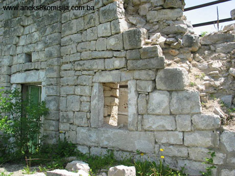
The Čelebić (Džaferović or Šurković) mosque in Donja Bijenja belongs to the type of single-space mosque with sofas and a square stone minaret. It stands in a courtyard surrounded by a low stone wall. The entrance to the plot is to the south.
The mosque had a hipped roof, with the north-west roof face extended so as to cover the entrance area with sofas.
The building has a rectangular ground plan, with exterior dimensions of approx. 11.50 x 8.70 m. The walls are of cut limesone with lime mortar as binder, and are about 70 cm thick. The walls are lime-mortar pointed on the outside, except for the part of the wall by the minaret and the lower part of the minaret itself, which are pointed with cement mortar. The walls were plastered and whitewashed on the inside. The walls were about 4.00 m in height measured in the central prayer space.
Judging from the ground plan and dimensions of individual structural elements, the mosque was probably originally roofed with stone slabs.(2) During one of the many interventions carried out this cladding was replaced with tiles. Evidence in support of this can be found in the village of Kruševljani, not quite 20 kilometres from Bijenja, where there was a mosque of the same type until the recent war in BiH. This mosque was clad with stone slabs. The site from which the slabs were extracted is very close to the village.
The entrance area of the mosque consists of sofas measuring 2.90 x 8.70 m, with a central passageway about 1.55 m wide. The south-west sofa was open on two sides, and measured 2.90 x 3.60 m. The north-east sofa was closed in on the north-east and north-west sides by a stone wall, 70 cm thick to the north-east and 65 cm thick to the north-west. The sofas were stone-paved. The roof structure of the mosque rested on the stone walls to the north-east and north-west and on a timber beam and three 16 x 16 cm timber pillars to the south-west. The pillars stood on stone bases measuring 30 x 30 cm. The sofas were raised by about 50 cm above the level of the entrance passageway.
The mosque had an interior wooden mahfil measuring 3.50 x 7.30 m. The mahfil abutted onto the entrance (north-west) wall of the mosque. Originally, the mahfil structure rested to the south-east on a timber joist and three massive timber uprights – one each against the side walls of the mosque and one at the centre of the span of the joist. To the north-west the load-bearing longitudinal beams constituting the secondary load-bearing structure of the mahfil were set into the stone entrance wall. Their sockets, and the rotten remains of the timber, are still visible in situ. The upper surface of these horizontal beams was at approx. + 2.30 m in relation to the floor of the entrance area. In one of the many interventions on the mosque, the crossbeam was replaced by a steel beam. Access to the mahfil was by a single-flight wooden staircase by the north corner of the building.
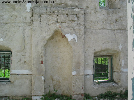
The entrance to the mosque was in the north-west wall, and was accentuated by a stone portal projecting outwards from the wall face by about 20 cm. It was about 3.20 m in height. The entrance door was wooden and of simple workmanship. The stone jambs of the portal are joined by a heavy stone lintel above which is a triangular panel set back by 5-10 cm from the plane of the portal, gradually narrowing towards the top in seven horizontal bands. There is no visible place in this panel that might have held a plaque with an inscription recording the date of construction or the mosque or the name of its builder. On the inside, the lintel of the entrance door is in the form of a shallow arch consisting of ten irregular arch segments.
The windows are to the north-west and north-east, in two rows. To the north-west, the windows are to be seen only at ground-floor level, while to the north-east not one window is still to be seen.
In the north-west wall of the building, by the entrance door measuring 1.00 x 1.90 m, there is just one window, by the western corner of the mosque, with the aperture measuring 80 cm on the inside and 58 cm on the outside. There are the vestiges of a window, now walled up, on the other side of the same wall, by the northern corner of the building. (3)
In the south-west wall the windows occupy two horizontal rows. The apertures of both the lower and the upper windows measure 80 cm on the inside and 58 cm on the outside. The entrance to the minaret is also in this wall, at mahfil level. This door is 70 cm wide and about 1.80 m high, and was round-arched. The remains of a walled-up door that was probably used as the entrance to the minaret before being walled up for some reason can still be seen at ground-floor level.
In the south-east mihrab wall there are two windows with apertures measuring about 95 cm on the inside and 60 cm on the outisde at ground floor level. In the upper part of this wall, at a height of about 3 m above ground level, directly above the lower window and thus about 2.70 metres from the southern corner of the mosque, there is a window the aperture of which measures approx. 30 cm on the outside. There is no fourth window, though logic would suggest there should be one on the opposite side by the eastern corner of the building.
There are no visible remains of what might be walled up windows or niches in the north-west wall of the building, since part of the wall is still covered by a thick layer of plaster.
On the outside, the window jambs and lintels were of cut stone blocks. On the inside, since the building was plastered, there is no particular treatment apart from the almost elliptical lintels of the lower windows and almost triangular lintels of the upper.(4) All the lower windows have wrought iron bars on the outside, all of which have survived.
The mihrab of the mosque measured approx. 150 x 250 cm, and was made of cut limestone blocks later plastered with lime mortar. The niche was of hemispherical hollowed form, with a depth of approx. 80 cm. The height of the mihrab niche is about 2.30 m. The frame of the niche projects outward from the wall face by 15 cm.
The minaret of the mosque was square in ground plan, measuring approx. 2.20 x 2.25 m, and was of cut limestone with lime mortar as binder. Stone minarets of square ground plan are found only in Herzegovina; in addition to the one in Bijenja, others in the Nevesinje region belong to the Perkušić mosque in Nevesinje and the mosque in Kruševljani, and to mosques in the environs of Bileća: the Avdić mosque in Plana, the Hasan pasha Predojević mosque in Grabovica, the mosques in Kljuni, Kružnje and Svinjarina; the Telarević mosque in Bjeljani near Stolac, as well as to the mosque in Glavatićevo near Konjica and the Fatima kaduna mosque in Mostar. The top of the minaret was in the form of a polygonal roof, the pitch of which was increased during the latest intervention, in the 1970s. Near the top of the masonry part of the minaret were four round-arched windows measuring approx. 40 x 90 cm, through which the muezzin would put his head when calling the azaan. There was an alem (finial) at the very top of the minaret.
3. Legal status to date
The building was not under legal protection.
4. Research and conservation and restoration works
Apart from a photographic record and research works carried out by Mr Hivzija Hasandedić as part of his study of the Muslim heritage in eastern Herzegovina, there have been no other research or conservation and restoration works on the building.
Most of the works on the building have been carried out by the inhabitants of the village on their own initiative. The latest such interventions were in the 1970s.
5. Current condition of the property
The mosque was destroyed in 1992. It was probably then that all the timber and woodwork was removed, since there are no signs of fire. Much of the north-east, south-east and south-west walls has survived. The north-west wall suffered the worst damage where it joins the minaret and where certain stone blocks have shifted out of position and are leaning outwards.
As a result of failure to take protective measures, there is extensive damp on the inside of the walls; the action of frost and hot sun on this has led to their progressive deterioration. This is particularly marked in the upper parts of the building.
In the interior, which was plastered, the plaster has fallen away from much of the surface as a result of deterioration of the binder. All that survies is part of the moulded iron window apertures and the original iron bars.
All the timber of the mahfil and floors was removed. The remains of the mahvil beams can be seen in their sockets.
The minaret was also completely destroyed; all that survives are the walls to a height of about 1 metre. All the fragments are in the mosque courtyard. A superficial survey revealed a large number of fragments belonging to the minaret stairway.
Since the mosque is not in use, the entire site is overgrown with weeds.
6. Specific risks
- Penetration of rainwater into the wall structure;
- Self-sown vegetation in and around the building.
Lack of maintenance and failure to take urgent protection measures could lead to the further deterioration of the building.
III – CONCLUSION
Applying the Criteria for the adoption of a decision on proclaiming an item of property a national monument (Official Gazette of BiH nos. 33/02 and 15/03), the Commission has enacted the Decision cited above.
The Decision was based on the following criteria:
A. Time frame
B. Historical value
C. Artistic and aesthetic value
C.v. value of details
D. Clarity
D. iv. evidence of a particular type, style or regional manner
E. Symbolic value
E.ii. religious value
E.iii. traditional value
E.iv. relation to rituals or ceremonies
E.v. significance for the identity of a group of people
F. Townscape/ Landscape value
F.i. Relation to other elements of the site
F.iii. the building or group of buildings is part of a group or site
H. Rarity and representativity
H.i. unique or rare example of a certain type or style
The following documents form an integral part of this Decision:
- Copy of cadastral plan
- Copy of land register entry and proof of title;
- Photodocumentation: a photograph dating from the 1970s, and photographs from the photodocumentation of the Commission to Preserve National Monuments of BiH;
- Reconstruction design project drawn up by the Stari Grad Mostar design office, with the following annexes:
o technical description
o bill of quantities and bill of costs of the works
o text from book by H. Hasandedić
o ground plan of ground floor, scale 1:50
o plan of mahfil, scale 1:50
o plan of substructure of dome
o plan of roof structure
o cross-section A-A
o cross-section of minaret
o north-west façade
o south-east façade
o north-east façade
o door and window fittings and woodwork
Bibliography:
During the procedure to designate the Čelebić (Džaferović or Šurković) mosque in Donja Bijenja as a national monument of Bosnia and Herzegovina the following works were consulted:
1939. Nametak, Alija, Islamski kulturni spomenici u Bosni i Hercegovini (Islamic cultural monuments in BiH) Herald of the Islamic Religious Community of the Kingdom of Yugoslavia, no. 1, January 1939, vol. VII, Sarajevo (using the services of the Gazi Husrev-beg Library in Sarajevo)
1990. Hasandedić, Hivzija, Muslimanska baština u istočnoj Hercegovini (Muslim heritage in eastern Herzegovina), Mešihat of the Islamic Community, El-Kalem, Sarajevo
1998, Mujezinović, Mehmed, Islamska epigrafika Bosne i Hercegovine (Islamic epigraphics of BiH), bk 3, 3rd ed., Cultural Heritage Series, Sarajevo Publishing
2005. design project for the reconstruction of the mosque drawn up by the Stari Grad Mostar design office.
(1) Krekovi is the largest stećak necropolis in the Nevesinje plain, and the second-largest in former Yugoslavia in terms of the area covered by the stećak tombstones (the largest is in the village of Cetini in Dalmatia, with 700 tombstones).
(2) Not even the oldest inhabitants of the village recall the mosque being roofed with stone slabs, which could have been done at the very beginning of the Austro-Hungarian period.
(3) The locals recount that there was a quarrel between two families, which was so grave that their members refused to enter the mosque through the same door, so that another was pierced in the mosque wall.
(4) Executed with a so-called semidome in stone with final treatment of plaster mouldings.
|