Status of monument -> National monument
Pursuant to Article V para. 4 Annex 8 of the General Framework Agreement for Peace in Bosnia and Herzegovina and Article 39 para. 1 of the Rules of Procedure of the Commission to Preserve National Monuments, at a session held from 3 to 9 May 2005 the Commission adopted a
D E C I S I O N
I
The historic urban area of Blagaj is hereby designated as a National Monument of Bosnia and Herzegovina (hereinafter: the National Monument).
The National Monument comprises the following areas:
- on the right bank of the river Buna, part of cadastral plot nos. 3784 (part: the area 50 m in width from the source of the river Buna, its right bank and the road from Blagaj to the source of the Buna), 1170, 1169, 1145, 1141, 1142, 1140, 1137, 1132, 1131, 1124, 1121, 1122, 1119, 1116, 1108, 1107, 1106, 1105, 1104, 1103, 1102, 1109 (part), 1110 (part), 1039, 1043, 1045, 1030, 1029, 1031, 1027, 1017, 1016, 1013, 1011, 1010, 1009, 1006, 1007, 1005, 690, 700, 701, 702, 703, 705, 706, 707, 708, 709, 712, 714, 715, 716, 870, 866, 832, 835, 836, 837, 842, 840, 843, 849, 845 and 846 across the river Buna to the left bank
- on the left bank of the Buna, c.p. nos.797, 827, 813, 811, 810 (part), 818, 815, 820 and 825, part of c.p. no. 3797 (an area 50 m in width from the left bank of the river Buna), c.p. nos. 1279/1, 1279/2, 1278 (part), 1277/1, 1277/2, 1277/3, 1276, 1323/2 (part), 1344, 1341, 1339, 1338, 1334, 1335, 1311, 1326, 1314 and 1316, part of c.p. no. 3787 (an area 50 m in width from the left bank of the Buna), c.p. nos. 1462, 1558, 1463, 1465 and 1466, 1515, 1512 (part), 1483 and 1484, paert of c.p. no. 3784 (an area 50 m in width from the source of the river Buna and its left bank);
cadastral municipality Blagaj, City of Mostar, Federation of Bosnia and Herzegovina, Bosnia and Herzegovina.
The provisions relating to protection and rehabilitation measures set forth by the Law on the Implementation of the Decisions of the Commission to Preserve National Monuments, established pursuant to Annex 8 of the General Framework Agreement for Peace in Bosnia and Herzegovina (Official Gazette of the Federation of BiH nos. 2/02, 27/02 and 6/04) shall apply to the National Monument.
II
The Government of the Federation of Bosnia and Herzegovina (hereinafter: the Government of the Federation) shall be responsible for ensuring and providing the legal, scientific, technical, administrative and financial measures necessary to protect, conserve, display and rehabilitate the National Monument.
The Government of the Federation shall be responsible for ensuring that a Programme for the on-going protection of the historic centre of Blagaj is drawn up, on the basis of which a detailed protection plan for individual ensembles within the protected area shall be drawn up.
The Government of the Federation shall be responsible for providing the resources needed to draw up and implement the necessary executive regional planning documentation for the historic urban area of Blagaj.
The Commission to Preserve National Monuments (hereinafter: the Commission) shall determine the technical requirements and secure the funds for preparing and setting up signboards with the basic data on the monument and the Decision to proclaim the property a National Monument.
III
The protected area shall be subject to three levels of protection, as follows:
Protection Level I applies to:
the cadastral plots identified in individual decisions of the Commission designating structures or ensembles within the protected area as National Monuments:
- the historic site of the Old Blagaj Fort – decision no. 06-6-1029/03-5. The National Monument is located on a site consisting of c.p. no. 1546, part of c.p. no. 3768 (the access path ot the Old Fort) and parts of c.p. nos. 3025, 3768 and 3769 (the shahids’ necropolis), c.m. Blagaj;
- the historic building of the Karađoz-beg hammam – decision no. 08.1-6-1029/03-6. The National Monument is located on c.p. no. 1345, c.m. Blagaj;
- the historic building of the Karađoz-beg bridge in Blagaj – decision no. 08.1-6-1029/03-7. The National Monument is located on c.p. no. 1548/1, c.m. Blagaj;
- the natural and architectural ensemble of the Tekke in Blagaj – decision no. 06-6-1029/03-8. The National Monument is located on a site designated as c.p. nos.1467, 1468, 1469, 1548, 1470, 1471, 1472, 4/22, 1473, 1474, 1475, 1476, 1477, 1478, 1479, 1480, 1481 and 1481, c.m. Blagaj;
- the architectural ensemble of the Imperial or Sultan Suleyman mosque – decision no. 06-6-586/03-3. The National Monument is located on c.p. no. 1358, c.m. Blagaj;
- the site and remains of the architectural ensemble of the Kolaković house – decision no. 09-2-1029/03-10. The National Monument is located on c.p. nos. 1229 and 1231, c.m. Blagaj;
- the natural and architectural ensemble of the residential complex of the Velagić family – decision no. 06.2-02-716/03-7. The National Monument is located on a site designated as c.p. nos. 1423, 1424, 1443/1, 1443/2, 1442, 1441/1, 1441/2, 1441/3, 1437, 1438, 1435, 1439, 1434, 1440, 1436, 1433, 1447, 1448, 1449, 1450, 1451, 1452, 1453, 1454, 1455, 1456 and 1457, c.m. Blagaj;
In the areas covered by the above Decisions the only interventions permitted are those designed solely for the protection and presentation of the properties and, as necessary, conservation and restoration works. The protection regime stipulated in each of the above decisions of the Commission shall apply.
Protection Level II applies to the area defined in Clause 1 para. 2 of this Decision and not forming part of Protection Level I. The following protection measures shall apply in this area:
- the only interventions permitted are those that will not be detrimental to the functional and formal integrity of the site, and pursuant in all cases to rulings set out in the executive plans referred to in Clause II para. 3 of this Decision;
- buildings may be adapted to suit modern uses; by way of exception, the interpolation of new buildings may be permitted on condition that they are not detrimental in form, size, materials used and exterior treatment to the structure of the protected area, pursuant in all cases to rulings set out in the executive plans referred to in Clause II para. 3 of this Decision;
- the layout shall be retained and existing open areas shall be restored and landscaped.
The executive plans shall include the following:
(a) An analysis of the current condition of the spatial ensemble, consisting of:
§ a chronological overview and stylistic definition of existing buildings;
§ an overview of the number of storeys of existing buildings;
§ an overview of the materials used;
§ damage;
§ degree of preservation;
§ a chronological overview of the use of the properties with a summary of their present use.
(b) A programme of urgent and intervention measures
(c) A plan for on-going measures to protect and present the heritage within the spatial ensemble, to comprise a detailed definition of the conditions in each individual instance for the purpose of:
§ the repair, conservation, making good and presentation of existing buildings and groups of architectural or townscape value;
§ the restoration and reconstruction of historic buildings, forms and areas for the purpose of ensuring the integrity of the historic centre and the recognizability of its specific features (reconstruction of destroyed buildings and structures, restoration of buildings or individual architectural features – horizontal and vertical dimensions, proportions, the number, size and arrangement of doors and windows, architectural details, paving, the form and pitch of roofs and the type of cladding, the treatment of facades and courtyard walls facing the street, etc.);
§ all planned interpolated buildings must be appropriate in height to the surroundings, and shall not detract in form from the specific features of the protected area;
§ all methods and degrees of intervention must be recognizable and shall be carried out solely on the basis of approved documentation;
§ the buildings shall be restored to their original use or used for new, non-destructive purposes appropriate to the central urban zone – small-scale catering and service facilities, traditional non-polluting crafts, culture and education, excluding uses the nature of which is contrary to that of the historic centre of Blagaj, which may cause noise or environmental pollution, or which require major alterations to the structure of buildings or groups;
§ no construction shall be permitted on protected green areas or other public spaces;
§ the pedestrian zone shall be set in order – street lighting, urban furniture, surfacing pedestrian and motor vehicle areas;
§ all works are prohibited that could have the effect of altering the landscape, flora or fauna;
§ existing tall vegetation and distinctive plant species must be retained;
§ the renovation of the existing infrastructure network with particular emphasis on mains water and sewers – resolve the question of the treatment of waste water and of the protection of the watercourse of the Buna;
§ the construction of major infrastructural facilities and industrial facilities within the protected area is prohibited.
No building, building-cum-artisanal or artisanal works stipulated by the Plan shall be carried out without the approval of the federal ministry responsible for regional planning and the expert supervision of the heritage protection authority of the Federation of Bosnia and Herzegovina.
(d) A heritage management programme for the protected area, identifying those responsible for implementing the programme.
(e) A phased programme for the implementation of the plan, with financial indicators.
Protection Level III applies to a protective strip, as follows:
The protective strip consists of the area bordering the protective zone with a width of 300 m, a strip with a width of 50 m along the watercourse of the Buna extending 500 m downstream from the protected area, and a strip 400 m in width on the slope from the source of the river Bunan to the Stjepan grad fortress.
The only interventions permitted within the protective strip are those that conform to the existing proportions and local features. The following protection measures are hereby stipulated:
- the structure shall be preserved, with restrictions as to the number of storeys, size and dimensions of the buildings, and the use of materials that closely resemble the indigenous materials and the traditional use thereof within the protected area;
- a detailed plan to make good the banks of the Buna and to provide for their use for public purposes (sport and recreation) shall be drawn up;
- existing tall vegetation and distinctive plant species must be preserved;
- a project shall be drawn up for the greening and landscaping of courtyards, gardens and public spaces, using indigenous plant species;
- the construction of quarries, potential environmental polluters, major infrastructure and industrial buildings and facilities is prohibited.
IV
All executive and area development planning acts not in accordance with the provisions of this Decision are hereby revoked.
V
Everyone, and in particular the competent authorities of the Federation of Bosnia and Herzegovina, the Canton, and urban and municipal authorities, shall refrain from any action that might damage the National Monument or jeopardize the preservation and rehabilitation thereof.
VI
The Government of the Federation, the Federal Ministry responsible for regional planning, the Federation heritage protection authority, and the Municipal Authorities in charge of urban planning and land registry affairs, shall be notified of this Decision in order to carry out the measures stipulated in Articles II to V of this Decision, and the Authorized Municipal Court shall be notified for the purposes of registration in the Land Register.
VII
The elucidation and accompanying documentation form an integral part of this Decision, which may be viewed by interested parties on the premises or by accessing the website of the Commission (http://www.aneks8komisija.com.ba)
VIII
Pursuant to Art. V para 4 Annex 8 of the General Framework Agreement for Peace in Bosnia and Herzegovina, decisions of the Commission are final.
IX
This Decision shall enter into force on the date of its adoption and shall be published in the Official Gazette of BiH.
This Decision has been adopted by the following members of the Commission: Zeynep Ahunbay, Amra Hadžimuhamedović, Dubravko Lovrenović, Ljiljana Ševo and Tina Wik.
No. 07.1-02-1029/03-37
5 May 2005
Sarajevo
Chair of the Commission
Ljiljana Ševo
E l u c i d a t i o n
I – INTRODUCTION
Pursuant to Article 2, paragraph 1 of the Law on the Implementation of the Decisions of the Commission to Preserve National Monuments, established pursuant to Annex 8 of the General Framework Agreement for Peace in Bosnia and Herzegovina, a “National Monument” is an item of public property proclaimed by the Commission to Preserve National Monuments to be a National Monument pursuant to Articles V and VI of Annex 8 of the General Framework Agreement for Peace in Bosnia and Herzegovina and property entered on the Provisional List of National Monuments of Bosnia and Herzegovina (Official Gazette of BiH no. 33/02) until the Commission reaches a final decision on its status, as to which there is no time limit and regardless of whether a petition for the property in question has been submitted or not.
II – PROCEDURE PRIOR TO DECISION
In the procedure preceding the adoption of a final decision to proclaim the property a national monument, the following documentation was inspected:
- Documentation on the location and current owner and user of the property
- Details of legal protection of the property to date
- Data on the current condition and use of the property, including a description and photographs, data of war damage, data on restoration or other works on the property, etc.
- Historical, architectural and other documentary material on the property, as set out in the bibliography forming part of this Decision.
The findings based on the review of the above documentation and the condition of the site are as follows:
1. Details of the historic urban area
Location
Blagaj (43.26° N, 17.89° E) stands at the edge of Bišće plain, in the south-eastern region of the Mostar basin. The town of Blagaj with the source of the river Buna and the mediaeval fort known as Stjepan grad constitutes a unique natural and urban-cum-rural ensemble.
It is located in a region where the Mediterranean climate still has an influence, with average temperatures in excess of 0° C, a high level of sunshine hours per annum, relatively low humidity, increased air currents, long hot summers, and wet winters (Vilušić).
An analysis of Blagaj's architectural heritage and old urban quarters (mahalas) indicates that buildings of major monumental and townscape value occupy a relatively confined area along the river Buna: from the Leho bridge to the source of the Buna, and from Bunsko and Harmana mahalas to the Džamija or Carska (Imperial) mahala (by the Bunsko brook). These constitute the boundaries of Blagaj's historic centre, with the oldest mahalas and the čaršija, the crafts and trade area. The other mahalas (with the exception of Do and Podgrađe) were much more sparsely populated, and their names were often derived merely from the toponyms of older residential areas.
The protected area of the National Monument is defined by a boundary running from the Leho bridge to the source of the Buna, and from the Bunsko and Harmana mahalas to the Džamija or Carska mahala by the Bunsko bridge, which also constitutes the limits of the historic centre with the oldest mahalas and the čaršija.
Historical information
The favourable geomorphic and climatic conditions of this region encouraged human settlement even in the remote past, so that the evolution of the area of present-day Blagaj can be traced since prehistoric times. Another factor favouring the development of settlement is the proximity of the river Neretva, one of the most important communications on the eastern Adriatic coast, which has carried considerable traffic from the interior to the coast and vice versa over the centuries.
Archaeological material found on the slopes of Blagaj hill provides evidence of the presence of settlements dating from the prehistoric and Roman periods. Cave dwellings have been discovered here – the Palaeolithic “Pećina Ševrljica” and Neolithic “Zelena pećina” – along with major archaeological sites dating from the Bronze and Iron ages.
To antiquity belongs the Romans' main settlement in Negočine, an important intersection of the four main roads leading to Narona, Stolac, Nevesinje and Konjic; Kosor and the Kosor bridge, over which the road to Blagaj ran. On the south-west summit of Blagaj hill, where the remains of the mediaeval Blagaj fort now stand, there were also fortifications dating from the Roman era, judging from the archaeological material on the slopes. The walls of a more solid fort (Mala gradina, meaning small hillfort) dating from the Roman period still protrude above ground on the opposite, north-east summit.
The earliest indirect written sources on Blagaj, as one of the towns of Zahumlje, are to be found in the list of peoples drawn up by the Byzantine Emperor and author Constantine Porphyrogenitus between 948 and 952 where two towns or forts are referred to – Bona and Hum (translator's note: this term “list of peoples“ frequently crops up in Bosnian texts but I can find no corresponding title in Constantine Porphyrogenitus' works. However, since his De Administrando Imperio deals largely with the peoples of the Balkan region and includes references to Bosnia, I wonder if it may refer to this work, or part of it.)
After the 10th century, too, Blagaj played a major part in the development of Hum or Zahumlje. The proximity of major routes linking the Adriatic coast with the Bosnian hinterland (“via Narenti”) influenced its development and importance. The mediaeval roads followed the route of the old Roman roads, as a result of which the major trade routes in the country in mediaeval times ran through Bišće and Blagaj. A number of settlements of the nature of market towns or varoši also grew up along these routes.
Prince Miroslav of Hum, during whose time the Church of SS Cosmas and Damian was built, resided in Blagaj (Orbini, Il Regno, p. 350). Information about the building of the church is to be found on the plaque known as the Blagaj stone, with an inscription in Cyrillic referring to the church of SS Cosmas and Damian, and therefore to a significant centre, at least in the local context. This plaque was found in 1912 close to the ruins of the old Bišće manor (or castle) and the place known as Vrači (Vego, 1957, p. 15). This plaque is now in the National Museum of Bosnia and Herzegovina.
There is considerably more extensive evidence of life in late mediaeval times (12th -16th century). As well as the administrative centre and strategically very important fort in Blagaj, suggested by the site of the ruler's court in Podgrađe near Blagaj, and the stone judge's seat found in the nearby village of Kosor, there are also stećak tombstones here, evidence of the artistic and spiritual expression of that time, and indicating population density and the socio-economic relations within the settlements.
By the reign of King Tvrtko the Bosnian rulers in Blagaj were issuing charters, and in May 1404 Blagaj became one of the residences of Duke Sandalj Hranić, and then of Herceg Stjepan Vukčić Kosača, after whom the fort became known among the local people as Stjepan-grad. The first written source referring to the fort is a peace treaty between Duke Sandalj Hranić and the Venetians, dated 1 November 1423, issued “in our fort in Blagaj.” In the 15th century, it is referred to in all three charters issued by King Alphonse V of Aragon and Naples.
The development of the town of Blagaj near Mostar continued uninterrupted in the Ottoman period, when it once again acquired administrative and political importance. Commanded by one Ahmed, the Ottoman army occupied Blagaj after 3 June 1466 (Šabanović, 1982, p. 44). After the occupation of Blagaj the Ottoman authorities installed a permanent garrison in the fortress, headed by a dizdar. With the arrival of a shari'a judge in Podgrađe, the Blagaj kadiluk took shape, remaining in existence until 1851, when it was abolished by Omer-paša Latas. The Blagaj kadiluk initially covered a wide area extending west-east, between the Neretva on the one hand and the Drina and Tara on the other. In about 1470, Blagaj became the centre of the Blagaj vilayet, with the same boundaries as the kadiluk. The saying “šeher Blagaj, a kasaba Mostar“ (Blagaj is a city, and Mostar a town) survives as testimony to the former primacy of the town on the source of the Buna (Mujezinović, 2000, p. 62).
The decline of Blagaj's importance is associated both with the development of Mostar and the formation of the Počitelj kadiluk in 1728, when a number of villages from the Blagaj, Mostar and Stolac kadiluks were allocated to this new administrative entity.
During the Ottoman period building activity began to flourish in the outskirts of the mediaeval fortress. Both residential and public buildings were erected, with a čaršija, a mosque and harem, a mekteb and a han located in the centre of town. At this time, vakufs – which were numerous in those days – played a major part in the development of settlements. Vakufs also provided for the maintenance of a building, and it was not uncommon, when a vakuf ceased to exist, for the building to be abandoned to the ravages of time (Vilušić).
As a result of the 1878 Congress of Berlin, during the forty years when it was administered by Austro-Hungary, Bosnia and Herzegovina was initially an occupied province under the formal sovereignty of the Sultan and, after annexation in 1908, part of the Dual Monarchy. After coming under Austro-Hungarian rule, most of Herzegovina consisted of one of the six districts into which the occupied country was divided. The Mostar district consisted of ten counties – the urban county of Mostar, the rural county of Mostar, and the counties of Bileća, Gacko, Konjic, Ljubinje, Ljubuški, Nevesinje, Stolac, Trebinje (Peez, 1891, p. 85).
The decline in Blagaj's importance continued during the Austro-Hungaria period. In the late 19th century, Karl Pec, who was staying in Mostar, said of Blagaj that it had a population of about 700, and that there were fewer Christians than Muslims. At that time Blagaj was a summer resort for the wealthier citizens of Mostar. The entire area was involved principally in agriculture. Most of the land was used as pastures and meadowland, with only a small proportion under crops.
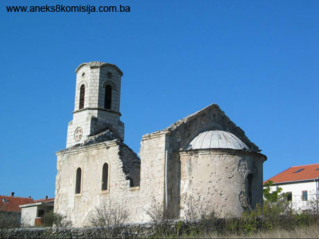
With the laying of the narrow-gauge railway track between Mostar and Metković in 1895, Blagaj was linked, via Buna where the railway station was located, with other regions. Not long after this, a post office was opened in Blagaj and two churches were built, the Serbian Orthodox church dedicated to St Basil of Ostrog in 1892 and the Catholic church built in 1902.
Its situation remained unaltered during the time of the Kingdom of Yugoslavia.
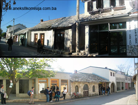
2. Description of the historic area
Blagaj is one of the most valuable urban-cum-rural structures in Bosnia and Herzegovina, distinguished from other similar structures in:
- its much-ramified, disjunct urban layout, organically linked solely with the position of the čaršija as the central functional element;
- the presence of the fortress of Stjepan grad, to which two minor and one major road formerly led.
Blagaj’s urban structure, spatial physiognomy and organization can be traced from the mediaeval outskirts of the fort, which were transformed in the Ottoman period into a kasaba (town), and then into an administrative centre. The Austro-Hungarian period brought no changes to Blagaj’s urban development. The period between the two world wars was marked by stagnating urban development, lasting until 1961 when there was a sudden increase in the population and unplanned building of residential areas.
Historical written sources rarely refer to the mediaeval settlement outside the fortress, Podblagaj, despite the important role of the fortified town of Blagaj in mediaeval times, as a prominent administrative centre. The earliest reference to Podblagaj dates from 1447. The settlement was located at the foot of the Blagaj fort, where the road runs down from the fort and intersects with the Nevesinje road. However, despite the fact that major trade routes ran through this area and that a settlement took shape on the outskirts of the fortress, it was a natural economy that dominated. There was too little trade for a commercial centre to emerge. In an agricultural environment of this kind the circumstances were not such as to give rise to an urban settlement, let alone its subsequent development (Vilušić).
The urbanization of the settlement of Blagaj as we now know it was defined in the Ottoman period, during the second half of the 15th century, and its structure took shape during the 16th century. The mediaeval fortress of Blagaj (Stjepan grad) is constantly referred to in the sources as a distinct territorial entity.
It was during the Ottoman period that building activity began to develop in the outskirts of the fortress, with the erection of houses and of public edifices, with the most important buildings located along the three watercourses: Suhi potok (brook) in Harman, Suhi potok in Galičići, and the river Buna, or more exactly the road above it (Hasandedić, 1997, p. 15). The centre was occupied by the čaršija, the trade and crafts centre of the settlement, the mosque complex with its harem and mekteb, and the han. The residential area took shape typologically as urban quarters or mahalas, with buildings facing inwards onto their courtyards, and rural areas with the buildings facing outwards.
Residential complexes came into being, evidence of a high standard of living; the complex of the Velagić house is one of the most valuable groups of this type in Herzegovina (Mujezinović, 2000, p. 63).
According to historical findings, the settlement of Blagaj never had a planned urban layout. It is plain to see, however, that the entire settlement was built according to a specific town-planning concept – its spatial evolution can be traced over the centures from the first fortifications (Mali grad and Stjepan grad) to the present-day three-pronged structure and surrounding residential quarters. This urban plan is based on certain rules or principles deriving from the wishes of wealthier families, who established their holdings in the residential quarters, and particularly in Donja Mahala. Notwithstanding pronounced partial features, building in these quarters was defined by the urban layout and architectural physiognomy of the čaršija, with the building of the road from Bunsko to the source of the Buna and from the source to the Carska mahala.
Both oriental and Mediterranean features are to be seen in Blagaj's urban layout, while the settlement itself was the outcome of the influence of a number of different factors: the natural configuration of the terrain, and socio-economic relations. A perfect harmony between each house and its environs was achieved. Residential complexes took on a new relationship with the outside world. The expansiveness and openness of the čaršija streets was dictated by the need to build free-standing, and at times entirely isolated buildings, so that the courtyard became the most important area of the house. These residential complexes consisted of several different buildings serving different purposes, standing on a plot that was entirely open to the natural surroundings and forming a single unit with the architecture of the buildings. This is at its most striking in the case of the Velagić and Kolaković complexes.
The new Ottoman administration began with the formation of a settlement according to established town planning principles. Building land was marked out, thus defining the area to be occupied by the future town. The new town planning principles are most readily observed on the basis of the chronological erection of mosques and residential quarters or mahalas, which took place in Blagaj in the following order:
- mahala Džamija (Varoš or Carska) originated with the erection of a mosque in the name of Sultan Suleyman II the Lawgiver (the Magnificent) in 1520-21. This mahala is in the centre of Blagaj town, and acquired its name from the mosque built there;
- mahala Bunsko originated with the expansion of the mediaeval township and the construction of a mosque by the legator Ćejvan Čehaja prior to 1554. This mahala is some 1.5 km from the town centre, and grew up along the road that until 1903 was the only passable road between Mostar and Nevesinje;
- mahala Zir (Donja or Hasan-agina) originated before 1664 with the erection of the Hasan-aga mosque. It is very close to the river Buna and the bridge over which the mediaeval road for Buna and Počitelj ran;
- mahala Do also originated before 1664, with the erection of a mosque that was the endowment of Hajji Husein ef. Bašba. Mahala Do is at the extreme northern edge of the town; Murat Spahija. This residential quarter is very close to the source of the river Buna, by the left bank;
- mahala Galičići originated in the first half of the 18th century. This residential quarter is very close to the source of the river Buna, by the left bank;
- other mahalas in Blagaj that are mentioned are Podgrađe and Kosor, which date from the existing mediaeval township. Podgrađe is about 2 km to the west of Blagaj centre, and Kosor between the rivers Buna and Bunica, south-west of Blagaj.
With the formation of these mahalas, the area and lines of development of Blagaj town were laid down, with clearly defined residential areas, the mahalas, and the trade and crafts centre or čaršija. With the construction of mosques, the basic roads network was also laid out, running parallel and at right angles to the river and forming the shortest link to the town centre. The selection of areas to build residential quarters and their actual construction were based on topographical features, particularly access to water. The town developed along the river Buna, running right down to the river banks. The left bank is somewhat steeper and less suitable for building, as a result of which most of the residential quarters are on the right bank of the Buna.
Public buildings were sited very deliberately in the urban structure as a whole. Among the first to be built was the Careva (Imperial) mosque in 1520/21, with which the settlement acquired the status of kasaba, followed by the Karađoz-beg bridge in 1570 and the Leho bridge prior to 1664. The hamam was built between 1570 and 1664, the han before 1664, and a number of shops and more solidly-built storerooms and residential buildings.
The commercial centre of the town, the čaršija, was planned from the start for the long term, with a view to building up the kasaba into a šeher or sizeable town. The most active period of building was the 16th century, when the town came to occupy its entire area. By the late 16th century Blagaj was a šeher, highly organized functionally, aesthetically and sociallly, but in the 17th century, when it was visited by Evliya Çelebi in 1664, Blagaj was a small kasaba.
The development of crafts and trade, and with it the economic prosperity of artisans and merchants, in the Ottoman period also had some influence on the construction of Blagaj, reflected in the expansion of the čaršija and the development of the mahalas. The trades pursued in the čaršija included the trades of tailor (terzija), saddler (sarač), blacksmith, tanner (tabak), tinsmith (kalajdžija), dyer (bojadžija), baker, miller, and barber (berber), with Blagaj's artisans and craftsmen referred to in the registers as lessees, guarantors and witnesses. There were three types of catering establishment in the čaršija: coffee-houses, taverns and bozadžinice (serving boza, a refreshing drink made from cornmeal). The Blagaj kadiluk had masons, stonemasons, and craftsmen skilled in bricklaying and the repair of fortifications and bridges. The revenue from shops and storehouses was used for the maintenance of religious buildings, the tekke, the han and the hammam. The wealth of Blagaj's artisans and merchants was more important for the town's prosperity than its administrative role in the political organization of the Herzegovina sandžak, though this too did contribute to the rise of Blagaj’s standing in the region, at least until the first half of the 16th century. In the early stages of Blagaj's urbanization an important part was played by its mills, initially built to grind grain for the army. Mills and stamping mills were built over the water; they were either privately owned or the property of individual vakufs. Somewhat later, Ali-paša Rizvanbegović embarked on a land improvement programme in Herzegovina, introducing the cultivation of rice, olives, vines and mulberries, and opening the first sawmill in Blagaj in 1851 (Hasandedić, 1976, p. 18, Kreševljaković, 1971, p. 281, Hadžibegović, 1998, p. 127).
The use of bold structural solutions also played an important part in Blagaj's architecture: the use of pillars and vaults, along with other structural elements, is plain to see. Barrel vaults are common (in mosques, the tekke and the hammam), taken to a high degree of perfection and thereby making possible an entirely free ground plan. The synchronization of development between artisanals crafts and building techniques on the one hand and the development of the settlement on the other has left its mark on the unique image of Blagaj as a distinctive urban centre in BiH. Harmony of proportions, form and details dominates the recognizable image of Blagaj, together with natural features (Institute for the Protection of the Cultural, Historical and Natural Heritage of Bosnia and Herzegovina, 2000, p. 12).
During the Austro-Hungarian period the lifestyle changed, but Blagaj remained unaltered as an urban entity. There was not so much new building as to disrupt irrevocably the proportions and spatial relationships of the town's historic centre, so that Blagaj's layout and the historic size of its streets have survived to this day. Architecturally speaking, the stylistic influence of cosmopolitan architecture in a provincial interpretation can be observed. While the import of central European historicist-eclectic architecture was of insignificant proportions, the old Herzegovina-Mediterranean-oriental architecture stagnated and died out. During the Austro-Hungarian period, Blagaj still retained its character as an oriental-type settlement, both in its overall appearance and in its architectural and compositional details, though there was obvious deterioration of the urban fabric.
The architectural heritage of this period is the most recent cultural stratum, which made no mark on the town planning and stylistic development of Blagaj. For all that, the construction of residential-cum-commercial and school buildings in the commercial area of the town began to alter the traditional image of the čaršija with its shops and storehouses. The layout of these buildings was free and simplified. The exterior features and siting gave this category a certain architectural and townscape value.
It was at this time, too, that two religious buildings were erected – the Serbian Orthodox church, dedicated to St Basil of Ostrog, built in 1892 in the neo-Romanesque style, and the Catholic church dedicated to the Holy Trinity, built in 1908 in the neo-Gothic style (Vilušić).
Blagaj also remained isolated from the design and construction of the roads linking the major towns and cities of Bosnia and Herzegovina. This was a time when the Mostar-Nevesinje road ran through the centre of Blagaj, and was the only road suitable for traffic until 1903, when it lost its importance with the building of a new main road. The town also remained without a railway connection.
As a result of all this, the new economic passivity that began with Blagaj’s stagnation during the Austro-Hungarian period and was to continue until the end of World War II had a positive aspect, in that the layout of the town has survived to this day, and new building was not of such an extent as to disrupt irrevocably the proportions and spatial relationships of the historic centre of Blagaj (Vilušić).
PUBLIC BUILDINGS
Public buildings were built to be substantial: fortresses, mosques (Friday mosques and masjids alike), bridges, hans, hammams and the tekke.
The functions of these buildings were complex, ranging from the purely utilitarian to the psychological-cum-ideological. As a result, their exterior treatment and form are not of the type encountered in other environments, as separate buildings within the urban matrix, but are the outcome of a range of different factors.
Ensemble of the fortifications
Mali grad. The remains of Mali grad (Mala gradina) – meaning respectively small fort or small hillfort – are located on a small plateau about 1 km from Herceg Stjepan’s fort. It consists of two square towers linked by a wall that earlier researchers assumed could be identified with the Roman fort of Bona. The complex covers an area of approx. 40 x 15 cm. The dimensions, position and mainly antique building materials suggest that this was a place of refuge. In the late antique era it became too confined in size to accommodate the population, and new refuges (later Stjepan grad) were built to provide places of refuge at times of crisis (Institute for the Protection of the Cultural, Historical and Natural Heritage of Bosnia and Herzegovina, 2000, p. 6).
Stjepan grad. Unlike other fortifications serving as residences in Bosnia and Herzegovina, the Blagaj fortress is located on a natural level area above steep cliffs to the south, west and north. In layout, the fort is an irregular polygon, adapted to the configuration of the terrain, with seven square towers, a projecting angle, and the entrance to the east. Access is by way of a narrow horse track winding its way up in sharp serpentine bends to the entrance in the most strongly fortified east wall of the forecourt. The walls have survived for much of their length to a height of 12 or 14 m. The interior defended area is relatively small, similar to that of the fortress in Jajce.
More detailed information on this building may be found in the Decision designating the Historic site of the old Blagaj fort near Mostar as a National Monument.
Religious buildings
There are several religious buildings in Blagaj, with masjids predominant. Among the first buildings to be erected in Blagaj was a Friday mosque, used both for daily prayers and for social gatherings of the congregation. As the town grew, masjids (smaller religious buildings without a mimber [pulpit], and usually without a minaret too) were also erected.
In choice of site and degree of preservation, there are significant differences between the various buildings. The largest mosque, the Careva (Imperial) or Sultan Suleyman mosque, stands in the central mahal, and the oldest is in Stjepan grad. In addition to the Ćejvan-ćehaja masjid in Bunsko, the Hasan-aga masjid in Donja mahala, the Hajji Jusuf masjid in Do, the Hajji Murat masjid in Galičići and the Ali-paša Rizvanbegović mosque on the source of the Buna, the most famous religious building in Blagaj is the Tekke and musafirhana with turbe, constituting as a whole the most original religious-cum-residential building of Ottoman architecture in BiH (Institute for the Protection of the Cultural, Historical and Natural Heritage of Bosnia and Herzegovina, 2000, p. 7).
The Sultan Suleyman (Careva, Imperial) mosque was one of the first buildings to be erected in Blagaj township, in 1520/21. It is very close to the right bank of the river Buna in the centre of Blagaj, and is one of the oldest domed mosques in this region, with the features of a single-space domed mosque. The mosque was built in line with the rules governing the construction of monumental edifices. The choice of site ensured that it would have a wide “catchment area” and be of prime importance in the čaršija as an organic entity. The mosque stands on the edge of the Carska mahala, facing the square and čaršija, which shape buildings of public importance. The desire to ensure that the building is in direct contact with its environs and to form an integral part of the daily life of the town is evident, and gave rise to the monumentalism of the mosque, not by accentuating the decorative features of its individual components but by means of the relationship between solid and open surfaces. There is a walled courtyard or harem outside the building. A mekteb or Muslim religious school was built by the Sultan Suleyman (Careva) mosque prior to 1664.
More detailed information on this building may be found in the Decision designating the Architectural ensemble of the Careva or Sultan Suleyman mosque in Blagaj as a National Monument.
The architectural ensemble of the Blagaj Tekke stands by the source of the river Buna, not far from the centre of Blagaj. The musafirhana and turbe are tucked into the natural surroundings, constituting a single entity with the cliffs, source of the Buna and mills. The musafirhana of the Blagaj tekke and the turbe have been preserved to this day. The musafirhana was built before 1664, and rebuilt in 1851; its original appearance is not known. The building was subsequently repaired on several occasions. The ensemble of the Blagaj Tekke was presumably built very soon after Ottoman rule was established in Herzegovina, around 1520 at the latest. If was originally in the hands of the Bektashi order, and later, in the 18th century, after renovation by the Mufti of Mostar, Zijadin Ahmed-ibn-Mustafa, it became a gathering-place for members of the Khalwatiyyah order (Mujezinović, 2000, pp. 55-66). The earliest reference to the tekke on the source of the Buna in Blagaj near Mostar is in the Travelogue by Evliya Çelebi, who travelled through the town in 1664. The musafirhana of the Blagaj tekke is a highly original residential building, with very marked features deriving from the influence of the baroque on Ottoman architecture. The baroque influence is reflected in the gable of the main facade, where the roof is slightly curved, a design that is not appropriate either to the style and stone slab roof cladding in Herzegovina or to the material of which it is made. A turbe was built by the Blagaj tekke, an elongated structure attached to the residential part, with two tombs.
More detailed information on this building may be found in the Decision designating the Natural and architectural ensemble of the Tekke in Blagaj on the Buna as a National Monument.
Masjids. All Blagaj’s masjids have been demolished or are no longer in use. They were built of stone, with hipped roofs clad with stone slabs.
The Ćejvan Čehaja masjid in Bunsko mahala was commissioned by the Mostar legator Ćejvan Čehaja before 1554, as can be learned from his deed of endowment. All that now survives is parts of two walls. It was built on a level site near a brook, a few metres to the left of the road. A well was built by the masjid, and was used by the inhabitants of Bunsko mahala, as was a mekteb, about which nothing is known. It is known only that it was endowed by Ćejvan Čehaja and maintained by his vakuf (Hasandedić, 2000, pp. 49-50).
The Hasan-aga masjid in Donja mahala was built not far from the right bank of the river Buna and the stone bridge. It has been known by various names: as the Leho mosque, after the Lehos who served there as imams; and as the Efičina mosque, after hajji Jusuf-aga Efica of Mostar, who repaired it in 1919. After adaptation the building housed a clinic; it is now used as a warehouse.
The Masjid of hajji-Jusuf ef. Bašba in mahala Do was built before 1664. It was an endowment of hajji Husein ef. Bašba, whose tomb with a large nišan tombstone is outside the masjid. The remains of a wall can still be seen. This site is known locally as the “Džamijetina”. With its harem, it occupies an area of approx. 620 m².
The Hajji-Murat Spaho masjid in Galičići was built in the first half of the 18th century. This was in fact the second masjid on this site; the first was demolished after the earthquake in early 1762. It was built not far from the source of the river Buna, on the left bank. It was demolished in 1934, and all that is now to be seen is parts of the wall and the small mihrab.
The Masjid of Ali-paša Rizvanbegović was built by Ali-paša Rizvanbegović in about 1841, outside the tekke and turbe by the source of the river Buna. It was destroyed by a large rock in 1885. Parts of the walls and foundations are still visible (Vilušić).
The Church of St Basil of Ostrog was built during the Austro-Hungarian period. Work began in 1892 and was completed in 1893; the church was dedicated to the Assumption. The church was built in the neo-Romanesque style. There is an inscription in the church referring to its erection:
Vo slavu sijatija jedinosušnija životvorjašćija
i nerazdjeljnija trojici oca i sina i sjatoga duha
načini se ovaj sveti i božanstveni hram
u Blagaju u slavu i čast iže vo sjatih oca
našego mitropolita Vasilija Ostroškog čudotvorca
trudom i prilozima srpskog pravoslavnog naroda 1892. godine
(To the glory of the uncreated, consubstantial and coeternal Trinity of the Father the Son and the Holy Spirit, this holy divine temple was built in Blagaj to the glory and honour of our great Father Metropolitan Basil of Ostrog the Miracle-worker, with the labour and donations of the Serbian Orthodox people in 1892).
The plaque measures 80 cm wide by 100 cm high. The belltower was erected in 1934.
In the early 1880s an inventory of the church was conducted, when icons were discovered in old ecclesiastical vestments no longer in use and in the area of the choir below the pillars. Here too a number of oils on canvas were found, amateur works dating from the 1940s. The paintings had been donated to the church in memory of deceased persons. In addition, a number of broken candlesticks and one cast silver icon lamp were found. The paintings were presumably hidden during World War II. All these works of art were damaged as a result of being kept in unsuitable conditions.
The church had 15 icons, varying in both artistic and historical value, and dating from between the 15th/16th and the 19th centuries. Among the most valuable were: “Unidentified saint,” “The Harrowing of Hell,” “St John the Evangelist,” St Pantelemon,” and “Life of St George” (Ribarević-Nikolić, 1984, p. 202). The church also contained a number of modern Russian icons.
The iconostasis of the church was installed in 1893. It featured twenty saints painted in oil on canvas. The royal doors were also painted. The iconostasis remained in use until the recent war when, as reported by Father Danilo, all the movable items in the church were destroyed.
Memorial buildings
Burial grounds or harems form part of the mahala complexes. The memorial monuments of Blagaj are located on five sites, four of which are still in use:
- the Šehitluci or shahids' necropolis in Bunsko mahala in Blagaj
- the large harem in Blagaj
- the harem by the Sultan Suleyman (Careva) mosque
- the harem by the masjid in Galičići
- the harem in Podgrađe
The specific feature of these burial grounds are their nišan tombstones, which reveal the indigenous influence of the stećak tombstones and of the orient. The decoration is diverse, based again on both the local tradition and oriental designs; the epitaphs are in Arabic, Turkish and Persian.
The shahids’ necropolis in Blagaj. The old Muslim burial ground known as the Šehitluk is located below the fort, hard by the road. Its tombstones have been almost entirely destroyed, although the outlines of several graves can still be made out and there are eight, mainly damaged, nišans to the left and right of the brook and the access path. This is probably the oldest necropolist in Blagaj.
More detailed information on this structure may be found in the Decision designating the Historic site of the Old Blagaj Fort in Blagaj near Mostar as a National Monument.
The Harem by the Careva mosque is to the south of the mosque entrance. According to Mujezinović, the harem contained twelve graves with nišans. All the nišans were of recent date, and the epitaphs show that it is mainly members of the Kolaković family who are buried there (Mujezinović, 1998, p. 316).
More detailed information on this structure may be found in the Decision designating the Architectural ensemble of the Careva or Sultan Suleyman mosque in Blagaj as a National Monument.
The Harem by the masjid in Galičići is one of the larger harems. The tombstones indicate that the members of the Velagić family are buried here.
The Harem in Podgrađe still contains a few old nišans without epitaphs.
The Large harem in Blagaj is the town cemetery, still in active use, and located in the centre of town. The oldest dated nišan is of 1764. One of the graves is attributed to Haseći Ali-aga who built the han by the Careva mosque, and who allegedly bequeathed this plot to be used as the town cemetery (Vilušić).
Secular buildings
As well as religious buildings, other public buildings occupy an important place in Blagaj: the mekteb and medresa by the Careva mosque, the mekteb in Mejtefina in Bunsko, the Karađoz-beg hamam, two bridges – the Karađoz-beg and the Leho bridges – and two hans. The first of these, the Haseći Ali-aga han, is in the centre of Blagaj, and the other in Donja Mahala.
Mektebs were primary schools for the religious and moral upbringing of children and learning the Arabic script. They were not built in mosque courtyards but at the corner of the courtyard, with a separate entrance. This ensured that the mosque enjoyed the necessary peace and quiet, while the mekteb faced the mahala (Kasumović, 1999, p.131).
The Mekteb by the Careva mosque was built before 1664, and is first referred to in Evliya Çelebi’s travelogue. The mekteb is a single-storey building of rectangular ground plan, with two rooms. The mekteb building underwent complete adaptation in 1264 AH (1847/48), as recorded on the inscription incised on a plaque in the south-east façade wall of the mekteb.
More detailed information on this building may be found in the Decision designating the Architectural ensemble of the Careva or Sultan Suleyman mosque in Blagaj as a National Monument.
Hammams. The form and location of hammams in the structure of Bosnia’s towns is associated with the influence of Turkish hammams, introduced to Bosnia by the Ottomans. Turkish customs associated with bathing came into contact with those of Roman and Byzantine, initially in Anatolia, where there were local variations. Another crucial factor in determining the layout of hammas is the Islamic requirement to perform ritual ablutions, including bathing the entire body. The form and functions thus acquired a local expression in Bosnia.
A hammam was far more than just a place where one bathed. It was a social centre, where people of all social standings and ages, and of both sexes, were free to come for the same reason and where they enjoyed the same treatment: together, after a steam bath, massage, scraping, bathing and perfuming (men with musk, women with ambergris), they would drink a hot beverage in the rest area. From the individual standpoint, the hammam was a family area from birth to death.
The Karađoz-beg hammam is on the right bank of the river Buna, very close to the Careva mosque and Karađoz-beg bridge. It was endowed by Mehmed-beg Karađoz, and built between 1570 and 1664. It is of small size, and in layout is a single hammam, built of stone and brick and consisting of a šadrvan, kapaluk, halvat, hazna and ćulhan (apodyterium, tepidarium, caldarium, boiler room and hypocaustum). This is one of the few hammams built by a river, from which the water was drawn by means of a special channel. It is said that it was used as an abattoir for a long time, and was probably abandoned in 1814 after the plague that ravaged the country at that time. Most of the hammam is now in ruins and all that can be discerned is part of the ground floor walls and part of the dome over the šadrvan. The river Buna, time and the elements, and human neglect, have resulted in only parts of the šadrvan, kapaluk and halvat of the Karađoz-beg hamam surviving.
More detailed information on this building may be found in the Decision designating the Historic building of the Karađoz-beg hammam in Blagaj near Mostar as a National Monument.
Hans were built in or very close to the čaršija. They were used primarily for rest and overnight accommodation for kiridžija hauliers (hired men transporting goods by horse and cart)and their caravans, but trade was also conducted in them. When people began to drink coffee in this part of the world, and alcoholic drinks were also served in the hans, they became coffee-houses and taverns.
There were also musafirhanas in the towns and villages and by the roadside. These were purely charitable institutions, where travellers could obtain food and lodging for themselves and their horses, free of charge (Kreševljaković III, 1991, pp. 255-269).
In the architectural structure of the settlement, the han was usually located in the čaršija, surrounded by shops, since it was used for trade, and close to the hammam and mosque. There were two hans in Blagaj. Haseći Ali-aga's han stood by the road that used to lead to Stolac. The other was in Donja Mahala by the road that led over the Leho bridge to Buna and Počitelj (this one has been demolished). Hans differed in appearance from other residential buildings. They had hipped roofs. The ground floor usually had stabling for horses, a large dormitory and a room where coffee and food were served. They were the private property of individuals, who ran them themselves or leased them out on an annual basis (Vilušić).
The Haseći Ali-aga han was built before 1664 very close to the Careva mosque. By 1700 it was already dilapidated. It was stone built, with two storeys. The ground floor housed the stables, storeroom and inn, and the first floor the rooms. The remains of three fireplaces are visible on the south courtyard wall, typical of such simple buildings, along the wall on a raised platform. The original appearance of the han was changed by various alterations and additions, as can be seen from walled-up windows, new construction, and new windows. Most of the building is in a state of neglect (Vilušić).
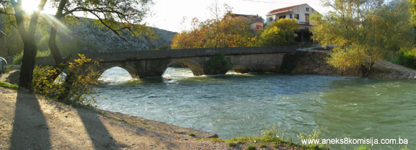
Bridges. There were four bridges over the 8 km of the river Buna, two in Blagaj, one in Kosor and one in Buna. The bridges in Blagaj are still in use, their appearance considerably altered (Vilušić). Blagaj's bridges, the Karađoz-beg and Leho bridges, differ in certain features from the typological form of 16th century Ottoman architecture.
The Karađoz-beg bridge was endowed by Zaim hajji Mehmed-beg, known as Karađoz, and was built before 1570. The road to Stolac led over the bridge, which has five arches, of increasing span towards the centre. It has twice been repaired, following World War II bombing and following a major flood in 1960. The Karađoz-beg bridge is in use, and is in good structural condition.
More detailed information on this structure may be found in the Decision designating the Historic structure of the Karađoz-beg bridge in Blagaj on the Buna as a National Monument.
The Leho bridge or Lehina ćuprija in Donja Mahala was built before 1664. It is assumed to have been commission by Haseći Ali-aga Kolaković. It had three arches, considerably wider than those of the Karađoz-beg bridge. The slightly pointed barrels were of finely-cut stone. On the upstream side, the piers had triangular breakwaters (Vilušić). The bridge was damaged in the 19th century (prior to 1890), and in about 1930 the piers were replaced in an unsatisfactory manner; only one arch now survives. The bridge has lost most of its original features, with its original appearance radically altered.
Mills.
The mills by the Tekke. Very close to the source of the river Buna, channels branch off leading water to power the mills. Several mills, stamping mills and two fulling mills were built. There was one mill on each bank of the river. Part of the mill on the right bank of the river has been converted into a souvenir shop; all that remains of the rest of the mill is the stone walls. As a rule mill buildings are simple stone-built structures with gabled roofs clad with stone slabs, and with one or more mills.
More detailed information on this building may be found in the Decision designating the Natural and architectural ensemble of the Tekke in Blagaj on the Buna as a National Monument.
The mills in the Velagić complex. Part of the mill is on the bank and the greater part on the branch of the river Buna that flows beneath the Velagić residential complex. The mill is to the west of the houses, not far from them but right by the stables and stamping mill, which is slightly upstreamfrom the mill. Stamping mills were used for washing wool and fulling cloth. The mill building consists of two parts, one built on dry land with a ground and an upper storey, and the other a single-storey structure built over the river spanning the two banks by means of a system of arches. The first part was the miller's living quarters, and the other contained seven mills arranged at regular intervals.
More detailed information about this building may be found in the Decision designating the Natural and architectural ensemble of the residential complex of the Velagić family in Blagaj near Mostar as a National Monument.
RESIDENTIAL ARCHITECTURE OF THE OTTOMAN PERIOD
With the economic prosperity of the čaršija, particularly in the 15th and 16th centuries, when Blagaj reached its peak of development, building in stone also reached its greatest extent. The first stone-built houses were erected by the wealthier classes, but later artisans' families also built sizeable stone houses and summer residences (the Velagić ensemble with ada [eyot], the Kolaković house, the Drljević house, the Kosić tower). The interior and exterior layout of these buildings indicates a wealth of equipment of a functional nature. There is particular emphasis on the decorative features of individual components in wood or stone. The layout of most of these complexes is very similar. Depending on the quality of the building, spacious, shady rooms were arranged around a partly open antechamber, with the same layout repeated on the first floor.
The houses mainly had just one upper storey and a hipped roof, suggesting that both architectural configurations and ground plans were largely dictated by the specific spatial and town planning circumstances. In the early years, the type of house that evolved in Blagaj was one that extended horizontally, with a lifestyle to match.
The interior fittings of Blagaj's oldest houses was of a purely functional nature. The furniture and interior fittings were dictated by the lifestyle and the use of space, and never included any aesthetic effect or harmony. This is particularly noticeable in the general layout of residential areas, not merely that of individual buildings of outstanding value. The choice of building site was mainly close to the river Buna.
The town had several outstanding residential complexes of the Ottoman period: the Kolaković house (part of a residential complex, the building in ruins and derelict), the Velagić house, a complex in Galičići mahala on the left bank very close to the river Buna (derelict, in ruins), and residential buildings in Bunsko mahala (in ruins) by the old Nevesinje road.
The houses were built of local materials – stone and timber. The facades were plastered and whitewashed over quarry stone. Cut stone was used only for details.
During the Ottoman period, with the introduction of Islam to this part of the world, new types of rooms began to appear in the houses, such as the abdestluk (where ritual ablutions before prayer were performed), the hamamdžik (bathroom), musandera (built-in cupboards of standardized design), a spacious area outside the rooms known as the hajat on the ground floor and as the jazluk or, more rarely, the kamerija, on the first floor. The oriental influence can be sensed both in the interior, in the the layout, and in the way of life.
The ground floor rooms and first floor chambers were used for residential purposes, both day and night, with the furniture designed appropriately (musandera, sećija). The sećija or built-in wall seating usually occupied two walls, and was 80-90 cm wide and 10-30 cm high, with the musandera along the wall by the door, facing the windows. The musandera usually incorporated the door, a dolaf or cupboard for storing small items, a dušekluk for storing bedlinen during the day and a hamadžik or bathroom in the corner. The common parts of the house were the hajat on the ground floor and the tavan on the first floor, with a wooden staircase leading from one to the other in the open part of the hajat. In most of the buildings in Blagaj that have been studied, the staircase was by the side wall, which is not the most favourable position. Part of the tavan, usually one step higher than the rest, was known as the jazluk (kamerija), and was used for repose and leisure. It was closed off from the outside world by mušebak latticing, and usually faced the most attractive view of the natural surroundings. The house was clearly articulated vertically into the stone ground floor and the upper floor, made much lighter in appearance by half-timbered doksats (oriel windows, verandas). The houses were built of local materials, timber and stone. The facades were plastered and then whitewashed, given that the walls were of quarry stone. Cut stone was used only for details. Wooden tie beams known as hatulas were used to add rigidity to the walls. A frame of double tie beams would be set in the ground floor walls, with the floor/ceiling joists wedged between them. This type of joist structure could take a greater load and cover a wider span. A particularly wide span would often be reduced by setting a pillar with a corbel in the centre of the room (for instance, the spiral pillar in the centre of the hajat in the Kolaković house). The floor of the upstairs rooms were composed of floorboards 15-20 cm wide laid cross-wise over the wooden joists. The most highly decorated ceiling is to be found in the large ćošak (veranda) of the Kolaković house, which is dome-shaped. The house had a simple gabled or hipped roof, clad with limestone slabs set diagonally on close-set rafters (Vilušić).
The Kolaković house is one of the most striking examples of residential architecture in Herzegovina, and illustrates the evolution of the “Ottoman Bosnian” house. The original simple house with interior hall, dating from the 17th century, was considerably extended later to become a central-type house with central hajat. The residential complex of the Kolaković house consists of a selamluk (men’s and ”public” quarters) and haremluk (women’s or private and family quarters), and is a genuine example of a ”gentleman farmer’s” house. The distinction between a town house and a gentleman farmer’s house lies in the saračhana or courtyard with outbuildings (required for livestock) which, in the case of the Kolaković house, is right by the access road. The saračhana contained a musafirhana or overnight hostel, the mutvak of the musafirhana (hostel kitchen), ahar (stabling) and hayloft, and a house with a veranda. The exact date when the Kolaković house was built varies depending on the source being consulted, but it was probably built in the 17th century and enlarged and renovated in the 19th (Pašić, 1989, p. 171). It was destroyed during the war in 1993. The remaining walls are overgrown with vegetation.
More detailed information on this building may be found in the Decision designating the Site and remains of the architectural ensemble of the Kolaković house in Blagaj as a National Monument.
The Velagić house was built before 1776. “The Velagićevina residential complex is a unique complex of the residential architecture of that time, with a large number of the functional components required for life. It is so sited as to be separated from the outside world, while its exuberant facades seem to disperse as they open to the natural environment and the river Buna. All the courtyards are interconnected and paved with river pebbles. The complex of the Velagić house is the most complete example of a family house complex with outbuildings, where the full scope of the residential lifestyle of Herzegovina in the past is revealed.“ (Vilušić).
More detailed information about this building may be found in the Decision designating the Natural and architectural ensemble of the residential complex of the Velagić family in Blagaj near Mostar as a National Monument.
The Kosić tower, as an offshoot of mediaeval residential architecture, is a typical fortified house. It is stone-built and stands at the edge of the town, so it probably served some defence purpose, given that the Blagaj fort was on the other side.
The tower is square in ground plan, and has three storeys plus a basement, which was probably used as a dungeon. The top floor was covered over so that no one could fire into the tower. This floor was also fitted with loopholes in the walls, for defence purposes. Within the walls, the tower had all the features of a residential house – a row of cupboards with a hamamdžik (bathroom), and a mutvak (kitchen), so that life could proceed as normal even at times when the tower was being used for defensive purposes. It is now derelict. It was the rule for an odžak or manor house consisting of one or more houses used for residential purposes, with all the features of the developed type of house. This complex includes the remains of a building, probably used in part for residential purposes, but now derelict. Around the tower is a spacious courtyard surrounded by a high wall. The courtyard probably contained other buildings forming part of the complex, but these have not survived (Vilušić).
NATURAL HERITAGE
It is impossible to discuss the cultural and historical heritage of Blagaj without also considering its natural values, since its distinctive quality lies in the coexistence of the natural and the man-made, in the integration of the physical structure into the landscape.
Blagaj is a rich natural area, with varied contours, morphologically fascinating, with a pleasant Mediterranean climate of mild winters. In a relatively small area one can find both pronounced karst forms with steep slopes (Blagaj hill, Stjepan grad) but also level or gently sloping vales and river banks. The river Buna, though short, with its outstandingly clear water of high quality, is the habitat of a great many rare and endemic species of world ranking (the soft-lipped trout, the nose carp, the marble trout). Eagles once soared above the ramparts of the Blagaj fort, emerging from the cliffs above the source. When he travelled through this remarkable kasaba in 1663, Evliya Çelebi marvelled at the beauties of nature there; in his Seyahatnama he describes it as a place where eagles do not shun men . . . to the south of the fortress were once entire forests of pomegranate trees that sprang up and then disappeared (Mujezinović, 2000, p. 56).
This region is specific for the diversity of its above-ground and underground hydrography. The source of the Buna is the finest example of an underground karst river (producing approx. 30 m3/sec), one of the largest and most beautiful in Europe. The region is also known for the diversity of its flora and a number of endemic species. At lower altitudes there are many evergreen plant and deciduous thicket species, while at higher altitudes in the hills there is sparse forest. Fertile cultivable land is suitable for the agriculture typical of the Mediterranean climate.
According to the nomination for the list of national monuments in Bosnia and Herzegovina with the title Townscape ensemble of the town of Blagaj, drawn up by the Institute for the Protection of the Cultural, Historical and Natural Heritage of Bosnia and Herzegovina, the source of the Buna with its cliffs constitutes a geomorphological natural monument, and the source of the Buna a hydrological natural monument.
a) “A nature reserve is an area in which one or more of the original elements of nature (plant or animal species, their communities, relief, water) stand out in particular, and is primarily of scientific importance and purpose.” The following reserves may be defined in Blagaj:
- a geomorphological nature reserve – the Bunica gorge in Malo polje;
- a hydrological nature reserve – the course of the Buna and the Bunica;
- a zoological nature reserve – the ornithological area around Stjepan grad, the source of the Buna, the source of the Bunica and the Bunica gorge in Malo polje (Institute for the Protection of the Cultural, Historical and Natural Heritage of Bosnia and Herzegovina, 2000, p. 8)
b) “A natural monument is an individual original object or part of animate or inanimate nature (a geomorphological phenomenon, a mineralogical and palaeontological site, a source, waterfall, lake, watercourse, river or a site-designated example of the plant world, a spatially restricted botanical or zoological site), of importance from the scientific, educational, cultural or recreational point of view.” In Blagaj the following natural monuments may be identified:
- geomorphological natural monuments – the source of the Buna with cliffs, the source of the Bunica with cliffs, Zelena cave, Linčiji kuk cave, Šavrljicacave;
- hydrological natural monuments – the source of the Buna, the source of the Bunica, and the Buna falls (cascades in Blagaj);
- dendrological natural monuments – the plantings in the courtyard of the Tekke on the source of the Buna, the poplar plantation in the fish farm, the pine and cypress forest on the hill around Stjepan grad, the cypress plantations by the mosque in Blagaj, the cypress plantations by the Orthodox Church in Blagaj, the plantations of Mediterranean hackberry in Orah, and the wooded eyot (Institute for the Protectioin of the Cultural, Historical and Natural Heritage of Bosnia and Herzegovina, 2000, p. 9).
c) “A natural viewpoint is a natural or cultural area of major aesthetic or cultural and historical value.” In Blagaj the following viewpoints may be defined:
- Stjepan grad
- Kosorska glavica
- Gorica in Malo polje
d) “Sites of natural and historical interest are sites or specific aspects of nature associated with major historical or legendary events or major cultural monuments within a vegetative complex.” In Blagaj the following sites of natural and historical interest may be defined:
- The vegetative complex with Stjepan grad
- The protected complex of Glavica (Institute for the Protection of the Cultural, Historical and Natural Heritage of Bosnia and Herzegovina, 2000, p. 9).
3. Legal status to date
Pursuant to the provisions of the law, and by ruling of the Institute for the Protection of Cultural Monuments of SR BiH, no. 05-359-1/66 dated 12 March 1966 in Sarajevo, the site of the Stjepan grad fortress was placed under state protection.
Pursuant to the provisions of the law, and by ruling of the National Institute for the Protection of Cultural Monuments and Natural Rarities of NR BiH, no. 68/52 dated 31 January 1952 in Sarajevo, the Turbe, Tekke and musafirhana in Blagaj placed under state protection. By ruling of the Institute for the Protection of Cultural Monuments of NR BiH no. 02-685-3 dated 18 April 1962, the cultural monument of the Turbe, Tekke and musafirhana in Blagaj were entered in the Register of immovable properties.
Pursuant to the provisions of the law, and by ruling of the National Institute for the Protection of Cultural Monuments and Natural Rarities of NR BiH, no. 761/57 dated 30 April 1957 in Sarajevo, the Careva mosque in Blagaj was placed under state protection. By ruling of the Institute for the Protection of Cultural Monuments of NR BiH no. 02-828-3 dated 18 April 1962 the cultural monument of the Careva mosque in Blagaj was entered in the Register of immovable cultural monuments.
By ruling of the National Institute for the Protection of Cultural Monuments and Natural Rarities dated 17 June 1950, the Karađoz-beg bridge was placed under state protection. By ruling of the Institute for the Protection of Cultural Monuments of NR BiH dated 18 April 1962, the Karađoz-beg bridge was entered in the Register of cultural monuments.
By ruling of the National Institute for the Protection of Cultural Monuments and Natural Rarities dated 31 January 1952, the Kolaković house was placed under state protection. By ruling of the Institute for the Protection of Cultural Monuments of NR BiH dated 18 April 1962, the Kolaković house was entered in the Register of cultural monuments.
The source of the Buna is protected by ruling of the Regional institute for the Protection of Cultural Monuments in Mostar no. 744/54 dated 17 June 1954; $-13.
The Regional Plan for the Republic of Bosnia and Herzegovina to 2002 lists the urban and rural ensemble of Blagaj as a Category I monument (of national importance). The urban and rural ensemble of Blagaj means the area with the mosque, tekke, hammam, residential buildings and bridge.
The Regional Plan for the Republic of Bosnia and Herzegovina to 2002 lists the Blagaj fortress near Mostar as a Category I monument.
The Regional Plan for the Republic of Bosnia and Herzegovina to 2002 lists the Careva mosque, the Tekke on the Buna and the Karađoz-beg bridge as Category I monuments.
The Regional Plan for the Republic of Bosnia and Herzegovina to 2002 lists the Hammam in Blagaj, the Velagić complex and the Kolaković house as Category II monuments (of regional importance).
The Provisional List of National Monuments of the Commission to Preserve National Monuments includes the following properties:
- under serial no. 413, Mostar – Blagaj – Stjepan grad fortress
- under serial no. 414, Mostar – Blagaj – remains of the Kolaković house, designated on 22-23 September 1999
- under serial no. 415, Mostar – Blagaj – Tekke, designated on 30 June 1998
- under serial no. 416, Mostar – Blagaj – Karađozbeg bridge, designated at the Commission's 11th session in 1999
- under serial no. 417, Mostar – Blagaj – Lekina ćuprija, designated at the Commission's 11th session in 1999
- under serial no. 418, Mostar- Blagaj – Musafirhana, designated on 22-23 September 1999
- under serial no. 419, Mostar – Blagaj – remains of the Karađozbeg hammam, designated on 22-23 September 1999
- under serial no. 420, Mostar – Blagaj – Velagićevina, designated on 22-23 September 1999
Thus far the Commission to Preserve National Monuments has issued the following decisions designating properties as national monuments:
- Historic site of the Old Blagaj Fort in Blagaj near Mostar, no. 06-6-1029/03-5, designated at the 11th session, held from 6-11 December 2003
- Historic building of the Karađoz-beg hammam in Blagaj near Mostar, no. 08/1-5-1029/03-6, designated at the 11th session held from 6-11 December 2003
- Historic building of the Karađoz-beg bridge in Blagaj on the Buna, no.08/1-6-1029/03-7, designated at the 11th session held from 6-11 December 2003
- Natural and architectural ensemble of the Tekke in Blagaj on the Buna, no. 06-6-1029/03-8, designated at the 11th session held from 6-11 December 2003
- Architectural ensemble of the Careva or Sultan Suleyman mosque in Blagaj, no. 06-6-586/03-3, designated at the 12th session held from 20-26 January 2004
- Site and remains of the architectural ensemble of the Kolaković house in Blagaj, no. 09-2-1029/03-10, designated at the 12th session held from 20-26 January 2004
- Natural and architectural ensemble of the residential complex of the Velagić family in Blagaj near Mostar, no. 06/2-02-716/03-7, designated at the 15th session held from 6-10 July 2004.
4. Research and conservation and restoration works
- 1851 - Omer-paša Latas commissioned the first renovation of the architectural ensemble of the Tekke, turbe and musafirhana
- 1952 – the National Institute for the Protection of Cultural Monuments of NR BiH undertook the restoration of the turbe and musafirhana of the Blagaj tekke
- 1950 - Džemal Čelić surveyed the Kolaković house
- 1954 – the roof structure of the Kolaković house was repaired, the roof surveyed, and some beams replaced
- 1984/1985 – Gordana Vilušić studied and surveyed the Kolaković house and the Velagićevina residential complex
- 1989 – architect Amir Pašić studied the Velagić and Kolaković houses for his doctoral dissertation
- post 1995 – following the ravages of war, works to reconstruct and repair buildings within the historic centre were carried out on several occasions.
5. Current condition of the site
The historic centre of Blagaj is on the list of endangered monuments of Bosnia and Herzegovina. The current condition of architectural heritage buildings within the historic centre is such as to require active protection and restitution along with the introduction of a specific function. These interventions relate to both individual buildings and buildings forming part of ensembles.
The current condition of individual buildings of monumental value within the historic site is as follows:
- the Velagićevina residential complex, although surviving in its original form, is in relatively poor condition as a result of lack of maintenance and the illicit erection of a new residential building and catering facility with fish farm in the immediate vicinity. These structures are detrimental to the townscape value of the monument, and the Nordfish fish farm is a potential polluter of the natural environment, and in particular of the river Buna
- all that survives of the Kolaković residential ensemble is parts of the exterior stone walls of the building, which are overgrown with weeds; earth and garbage have been piled up inside the building, impeding access to the building
- the Careva mosque is in good structural condition. The mekteb building was in a ruinous state, and works have been carried out to rehabilitate it. The nišan tombstones in the mosque harem are in poor condition
- all that survives of the Karađoz-beg hamma is part of the walls of some of the rooms and part of the dome over the šadrvan. All the walls are overgrown with weeds. Access to the building is impossible because of the mounds of earth mixed with weeds and fallen pieces of the structure
- the Karađoz-beg bridge is in use and is in good structural condition
- the whole of Stjepan grad is in poor condition. In some places it can be seen that the revetment of the walls has fallen away and that interior walls have been displaced. The east wall has been broken through in places. The mosque has been altered using drystone walling. The remaining nišans in the burial ground below the fort are damaged, broken and, for the most part, displaced from the graves to which they belong
- the architectural ensemble of the turbe and musafirhana of the Blagaj tekke is in good structural condition. In addition to its religious use, the musafirhana is now also being used for catering purposes and the sale of souvenirs. The mill on the right bank of the river is in good condition, and is currently being used as a souvenir shop, but all that is left of the mill on the left bank of the river is the remains of the stone walls. The ensemble is at risk from the construction of a footbridge oer the Buna and a restaurant on the left bank very close to the source of the Buna, which is detrimental to the unity and authenticity of the architectural ensemble
- The church of St Basil of Ostrog was damaged during the war. Many of the residential and public buildings in the areas around the čaršija, the hammam and the Karađoz-beg bridge have lost features of townscape value as a result of uncontrolled and unplanned construction and other inappropriate interventions of recent date.
- In the contact area of the historic centre, the process of migration by the rural population (Behmeneovina, Batlaci, Pašinovci, Šehovina and part of Harmana) is having a negative impact, accompanied as it is by unplanned construction, as a rule of buildings that do not conform to the traditional features of Blagaj as a whole.
III – CONCLUSION
Applying the Criteria for the adoption of a decision on proclaiming an item of property a national monument (Official Gazette of BiH nos. 33/02 and 15/03), the Commission has enacted the Decision cited above.
The Decision was based on the following criteria:
A. Time frame
B. Historical value
D. Clarity
D. iv. evidence of a particular type, style or regional manner
D. v. evidence of a typical way of life at a specific period
E. Symbolic value
E.iii. traditional value
E.v. significance for the identity of a group of people
F. Townscape/ Landscape value
F.i. Relation to other elements of the site
F.iii. the building or group of buildings is part of a group or site
G. Authenticity
G.v. location and setting
G.vi. spirit and feeling
H. Rarity and representativity
H.i. unique or rare example of a certain type or style
The following documents form an integral part of this Decision:
o Copy of cadastral plan
o Copy of land register entry and proof of title;
o Photodocumentation;
o Drawings
Bibliography
During the procedure to designate the historic urban area of Blagaj as a national monument of Bosnia and Herzegovina the following works were consulted:
1891 Karl Pec, Mostar i njegov kulturni krug (Mostar and its cultural environs), Leipzig, 1891
1940 Dinić J. M., Zemlje Hercega Sv. Save (Land of Herceg St Sava), Jnl of the Serbian Academy of Science no. LXXXII, Belgrade, 1940
1940 Mehmed Mujezinović, Mjesto života (Place of Life), Jnl of the Serbian Royal Academy, Belgrade, 1940
1953 Bejtić, Alija, Spomenici osmanlijske arhitekture u Bosni i Hercegovini (Monuments of Ottoman architecture in BiH), Contributions to oriental philology and the history of the Yugoslav peoples under Turkish rule, III-IV, 1952-53, Veselin Masleša, Sarajevo, 1953
1954 Kreševljaković, Hamdija, Stari hercegovački gradovi (Old Herzegovina towns) Naše starine II, Annual of the Institute for the Protection of Cultural Monuments of SR BiH, Sarajevo, 1954
1957 Vego, Marko, Naselja srednjevjekovne bosanske države (Settlements of the mediaeval Bosnia state) Sarajevo, 1957
1969 Čelić, Džemal and Mujezinović, Mehmed, Stari mostovi u Bosni i Hercegovini (Old Bridges in BiH) Veselin Masleša, Sarajevo, 1969.
1971 Hamdija Kreševljaković, Esnafi i obrti u Bosni i Hercegovini 1463-1871 (Guilds and Trades in BiH 1463-1878), Selected Works II, Sarajevo, 1971
1972 Četvrt stoljeća službe zaštite spomenika kulture i prirode u Bosni i Hercegovini (A Quarter Century of Protection of Cultural and Natural Monuments in BiH), Naše starine XIII, Annual of the Institute for the Protection of Cultural Monuments of SR BiH, Sarajevo, 1972
1976 Hivzija Hasandedić, Glasnik vrhovnog islamskog starješinstva u SFRJ (Herald of the Supreme Islamic Council in SFRY), Sarajevo, 1976
1977 Gojko Grčić, Istorijski osvrt na tendencije razvoja do 1941. godine (Historical overview of development trends to 1941) Most no. 12-13, Mostar, 1977
1980 Institute for Architecture, Urban Planning and Regional Planning of the Faculty of Architecture in Sarajevo, Regional Plan for Bosnia and Herzegovina, Stage B – valorization of natural and cultural and historical monuments, Sarajevo, 1980
1984 Ivanka Ribarević Nikolić, Ikone pravoslavne crkve u Blagaju kod Mostara, (Icons of the Orthodox Church in Blagaj nr. Mostar), Hercegovina no. 4, Mostar, 1984
1989 Pašić, Amir, Prilog proučavanja islamskog stambenog graditeljstva u Jugoslaviji na primjeru Mostara, Koliko je stara stambena arhitektura Mostara autohtona pojava, (Contribution to a study of Islamic residential architecture in Yugoslavia, the example of Mostar, How far is the old residential architecture of Mostar an indigenous phenomenon) doctoral dissertation, Zagreb, 1989
1991 Kreševljaković, Hamdija, Izabrana djela II – Esnafi i obrti u Bosni i Hercegovini (1463-1878), (Selected Works II – guilds and trades in BiH 1463-1878) Veselin Masleša, Sarajevo, 1991.
1991 Kreševljaković, Hamdija, Izabrana djela III – banje, vodovodi, hanovi i karavansaraji (Selected Works III – baths, water mains, hans and caravanserais) Veselin Masleša, Sarajevo, 1991
1996 Čelebi, Evlija, Putopis – odlomci o jugoslovenskim zemljama, (Travelogue – extracts on Yugoslav lands) Sarajevo Publishing, Sarajevo, 1996.
1998 Mujezinović, Mehmed, Islamska epigrafika Bosne i Hercegovine, (Islamic epigraphics of BiH) vol III, Sarajevo-Publishing, Sarajevo, 1998.
1998 Ilijas Hadžibegović, Traganje za modernom Naronom (In search of the modern Narona) Hercegovina no. 10, Mostar, 1998
1999 Kasumović, Ismet, Školstvo i obrazovanje u bosanskom ejaletu za vrijeme osmanske uprave, (Education in the Bosnian eyalet during the Ottoman period) Islamic cultural centre, Mostar, 1999.
2000 Ayverdi Dr. Ekrem Hakki, Avrupa'da Osmanli Mimari Eserlera Yugoslavya II, 3. kitab, Istanbul, 2000
2000 Mujezinović, Nermina, Blagaj kod Mostara (Blagaj nr. Mostar) Hercegovina no. 11-12, Mostar, 2000
2000 Hasandedić, Hivzija, Mostarski vakifi i njihovi vakufi, (Mostar's vakifs and their vakufs) Majlis of the Islamic Community Mostar, Mostar, 2000.
2000 Institute for the Protection of the Cultural, Historical and Natural Heritage of Bosnia and Herzegovina, Nomination for the list of National Monuments of Bosnia and Herzegovina, the townscape ensemble of Blagaj, Sarajevo, 2000
Vilušić, Gordana, Master’s thesis, Sarajevo
Institute for the Protection of the Cultural, Historical and Natural Heritage of Bosnia and Herzegovina, Heritage Centre, Traditional details from buildings of the cultural and historical heritage in Bosnia and Herzegovina
|