Status of monument -> National monument
Pursuant to Article V para. 4 Annex 8 of the General Framework Agreement for Peace in Bosnia and Herzegovina and Article 39 para. 1 of the Rules of Procedure of the Commission to Preserve National Monuments, at a session held from 6 to 12 July 2004 the Commission adopted a
D E C I S I O N
I
The architectural ensemble of the Old Bridge and towers in Mostar is hereby designated as a National Monument of Bosnia and Herzegovina (hereinafter: the National Monument).
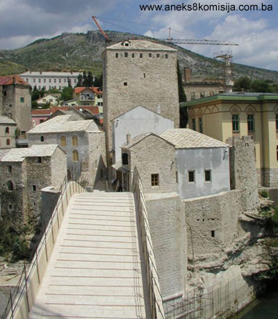
The National Monument consists of the Old Bridge, the Herceguša, Tara and Halebija towers with parts of fortifications, the masjid of Sultan Yavuz Selim, and the buildings within the complex on the west bank: a house between the Halebija and the wall of the upstream buttress, the entrance gatehouse south of the tower and the house above the entrance gatehouse; and on the east bank, three houses between the tower and the downstream buttress, and parts of the bed of the river Neretva by the bridge.
The National Monument is located on a site designated as cadastral plots nos. 5720/1, 5720/2, 3803 (new survey), corresponding to c.p. nos. 48/53 and 17/76, 17/77, 17/78, 17/79 (old survey), Land Registry entry no. 3805, cadastral municipality Mostar, City of Mostar, Federation of Bosnia and Herzegovina, Bosnia and Herzegovina.
The provisions relating to protection and rehabilitation measures set forth by the Law on the Implementation of the Decisions of the Commission to Preserve National Monuments, established pursuant to Annex 8 of the General Framework Agreement for Peace in Bosnia and Herzegovina (Official Gazette of the Federation of BiH nos. 2/02, 27/02 and 6/04) shall apply to the National Monument.
II
The Government of the Federation of Bosnia and Herzegovina (hereinafter: the Government of the Federation) shall be responsible for ensuring and providing the legal, scientific, technical, administrative and financial measures necessary to protect, conserve and display the National Monument.
The Commission to Preserve National Monuments (hereinafter: the Commission) shall determine the technical requirements and secure the funds for preparing and setting up signboards with the basic data on the monument and the Decision to proclaim the property a National Monument.
III
To ensure the on-going protection of the National Monument on the site defined in Clause 1 para. 3 of this Decision, the following measures are hereby stipulated:
Ÿ all works are prohibited other than conservation and restoration works with the approval of the Federal Ministry responsible for regional planning and under the expert supervision of the heritage protection authority of the Federation of Bosnia and Herzegovina,
Ÿ the Government of the Federation shall be responsible for providing the technical maintenance of the structure under the supervision of the relevant institutions.
A protective zone is hereby defined, consisting of the area designated as c.p. nos. 3798, 3799, 3800, 3801, 3802, 3805, 5714, 5715, 5716, 5717, 5718, 5719, 5721, 5722, 5723, 5724, 5725, 5726, 6470/2, which surround the site of the National Monument. In this protective zone, the following measures shall apply:
Ÿ the buildings shall be maintained under the supervision of the relevant institutions;
Ÿ changes of use to the buildings not in conformity with the traditional uses applicable in this urban zone (business, commerce and catering) are prohibited
Ÿ all construction on green spaces is prohibited and the existing vegetation shall be preserved (banks of the Neretva),
Ÿ the erection of billboards, advertising signs and other signs detrimental to or blocking the view of the townscape is prohibited
IV
All executive and area development planning acts not in accordance with the provisions of this Decision are hereby revoked.
V
Everyone, and in particular the competent authorities of the Federation of Bosnia and Herzegovina, the Canton, and urban and municipal authorities, shall refrain from any action that might damage the National Monument or jeopardize the preservation thereof.
VI
The Government of the Federation, the Federal Ministry responsible for regional planning, the Federation heritage protection authority, and the Municipal Authorities in charge of urban planning and land registry affairs, shall be notified of this Decision in order to carry out the measures stipulated in Articles II to V of this Decision, and the Authorized Municipal Court shall be notified for the purposes of registration in the Land Register.
VII
The elucidation and accompanying documentation form an integral part of this Decision, which may be viewed by interested parties on the premises or by accessing the website of the Commission (http://www.aneks8komisija.com.ba)
VIII
Pursuant to Art. V para 4 Annex 8 of the General Framework Agreement for Peace in Bosnia and Herzegovina, decisions of the Commission are final.
IX
On the date of adoption of this Decision, the National Monument shall be deleted from the Provisional List of National Monuments of Bosnia and Herzegovina (Official Gazette of BiH no. 33/02, Official Gazette of Republika Srpska no. 79/02, Official Gazette of the Federation of BiH no. 59/02, and Official Gazette of Brčko District BiH no. 4/03), where it featured under serial no. 377.
X
This Decision shall enter into force on the date of its adoption and shall be published in the Official Gazette of BiH.
This Decision has been adopted by the following members of the Commission: Zeynep Ahunbay, Amra Hadžimuhamedović, Dubravko Lovrenović, Ljiljana Ševo and Tina Wik.
Chair of the Commission
Dubravko Lovrenović
No. 07.1-02-903/03-29
8 July 2004
Sarajevo
E l u c i d a t i o n
I – INTRODUCTION
Pursuant to Article 2, paragraph 1 of the Law on the Implementation of the Decisions of the Commission to Preserve National Monuments, established pursuant to Annex 8 of the General Framework Agreement for Peace in Bosnia and Herzegovina, a “National Monument” is an item of public property proclaimed by the Commission to Preserve National Monuments to be a National Monument pursuant to Articles V and VI of Annex 8 of the General Framework Agreement for Peace in Bosnia and Herzegovina and property entered on the Provisional List of National Monuments of Bosnia and Herzegovina (Official Gazette of BiH no. 33/02) until the Commission reaches a final decision on its status, as to which there is no time limit and regardless of whether a petition for the property in question has been submitted or not.
At a session held on 30 June 1998 the Commission issued a Decision to add the Old Bridge and towers in Mostar to the Provisional List of National Monuments of Bosnia and Herzegovina, numbered as 377.
Pursuant to the provisions of the law, the Commission proceeded to carry out the procedure for reaching a final decision to designate the Property as a National Monument, pursuant to Article V of Annex 8 and Article 35 of the Rules of Procedure of the Commission to Preserve National Monuments.
II – PROCEDURE PRIOR TO DECISION
In the procedure preceding the adoption of a final decision to proclaim the property a national monument, the following documentation was inspected:
Ÿ Documentation on the location and current owner and user of the property
Ÿ Details of legal protection to date
Ÿ Data on the current condition and use of the property, including a description and photographs, data of war damage, data on restoration or other works on the property, etc.
Ÿ Historical, architectural and other documentary material on the property, as set out in the bibliography forming part of this Decision.
The findings based on the review of the above documentation and the condition of the site are as follows:
1. Details of the property
Location
The National Monument consists of the Old Bridge, the Herceguša, Tara and Halebija towers with parts of the fortifications, the masjid of Sultan Yavuz Selim, and other buildings within the complex, as well as parts of the bed of the Neretva by the bridge, and is located on c.p. nos. 5720/1, 5720/2, 3803 (new survey) or 48/53 and 17/76, 17/77, 17/78, 17/79 (old survey), Land Registry entry no. 3805, c.m. Mostar, City of Mostar, Federation of Bosnia and Herzegovina.
The complex of the Old Bridge and towers is in the oldest part of the town, right in the centre. It extends along both banks of the Neretva at the narrowest point of the river gorge at a place where the water level is quite well below the approach roads to the bridge. One of the features that led to the bridge being built on this spot is the presence of stable rocks on the bank itself, making it possible to build such a complex.
Historical information
The names of two towns appear in mediaeval historical sources, along with their later mediaeval territories and properties – the towns of Nebojša and Cimski grad. In the early 15th century the late mediaeval župa (county) of Večenike covered the site of present-day Mostar along the right bank of the Neretva: Zahum, Cim, Iliće, Hraštane and Vojno. It was at the centre of this area, which belonged to the Radivojević's in 1408, that Cim fort was built prior to 1443; it is referred to in a charter of King Alphonse V dating from 1454 as Pons (Bridge) (Civitas Pontis terrae or civitate Pontis cum castris et pertinentiis suis), for a bridge had already been built there. In the early 15th century, the Večenike župa probably also extended along the right bank of the Neretva, but that part did not belong to the Radivojević's. Prior to 1444, the Nebojša fort was built on the left bank of the Neretva, which belonged to the late mediaeval župa still known as Večenike or Večerić (Anđelić, 1974, 276-278)
The earliest documentary reference to Mostar as a settlement dates from 3 April 1452, when natives of Dubrovnik wrote to their fellow countrymen in the service of Đorđe Branković to say that Vladislav Hercegović had turned against his father and occupied Blagaj and other places, including “Duo Castelli al ponte de Neretua.” (Mujezinović, 1998, p. 144).
In 1468 Mostar came under Ottoman rule (Mujezinović, 1998, p. 144). The urbanization of the settlement began, following the unwritten oriental rule, with a čaršija – the crafts and commercial centre of the settlement – and mahalas or residential quarters. In 1468 Mostar acquired the name Köpruhisar, meaning fortress on the water, at the centre of which was a cluster of 15 houses (Institute for Regional Planning, Mostar, 1982, p. 21).
An entire urban complex took shape around the Old Bridge, in part even before it was built, but mainly during the 16th to 19th century. The Old Bridge was built to replace the mediaeval suspended timber bridge, to the orders of and with funds from Sultan Suleyman the Magnificent, at the request of the inhabitants of Mostar. The 17th century Turkish geographer Çelebi (Hajji Kalfa) wrote of the mediaeval bridge: “it was wooden, hung from chains and, since it was not reinforced by piers, shook so that one could cross it only in mortal fear.” As well as historical sources, there is physical evidence of the existence of this older bridge in the shape of some remains: about 20 m downstream from the present-day bridge, on the left bank of the Neretva, below the Ćejvan-ćehaja medresa, some fifteen metres above the summer water level of the bridge are the remains of walls, including a section assumed to have served as the footings of the bridge. On the other bank there are no traces of any older building, and the assumption is that they were destroyed when the present-day wing wall was built on the right bank downstream of the existing bridge. Based on these notes it may be deduced that:
Ÿ the bridge still existed in the first half of the 15th century
Ÿ that it was of timber construction, without piers
Ÿ that the load-bearing elements of the bridge were substantial wrought chains
Ÿ that the structure was subject to considerable movement both vertically and horizontally, lacking the necessary structures to provide rigidity
Ÿ that the bridge was slightly downstream from the present-day one
Ÿ that given the nature of the structure, it must have been much lower above water level than the present-day bridge.
On the basis of these facts, Milan Gojković attempted to arrive at a theory on the structure and appearance of the mediaeval bridge Čelić, Mujezinović, 1969, pp. 184, 185)
The account by Hajji Kalfa reveals that the present-day Old Bridge was completed in 1566, which coincides with the last year of the reign of Suleyman the Magnificent.
According to the inscription in Turkish, the bridge was completed in 974 AH, corresponding to the period between 19 July 1566 and 7 July 1567. A transcript of this chronogram has been preserved in its entirety in the collected papers of Muhamed Kadić, in the Gazi Husref-beg Library in Sarajevo. Since the inscription was not on the Old Bridge prior to its destruction, and since it is mentioned by Evliya Çelebi, the assumption is that it was
originally mounted on the bridge but that it was removed at some date later than 1664, when Evliya transcribed the year the bridge was built. The inscription also refers to Sultan Muhamed, of whom it is said that he left to posterity a similar work, a bridge. Documents published more recently confirm that prior to the construction of the Sultan Suleyman bridge there stood on this spot the bridge of Sultan Muhamed (Mehmed el-Fatih II). Yet another chronogram on the building of the Old Bridge, in verse in Turkish, recounts that the bridge was built in 1566. The two chronograms that were on the bridge itself when it was destroyed relate to its renovation, first in 1676 and later in 1737 (Mujezinović, 1998, p. 148).
A letter from a book with transcripts of the council of the Sultan's government in Istanbul (Muhimme Defter) dating from early April 1568 relates that the bridge was of recent construction and that the architect was mimar Hayruddin. Hayruddin is known to have been a pupil of the great Ottoman architect mimar Sinan (Koca Mimar Sinan, the leading Turkish architect from 1539 to his death in 1588) (Čelić, Mujezinović, 1969, p. 47).
According to a note found by Prof. Alija Nametak among manuscripts in the National Museum in Sarajevo, the building of the bridge began in 1557 and took nine years. The supervisor of the building works on the bridge was Hajji Mehmed Karađoz-beg, who was also responsible at this time for building the Karađoz-beg mosque in Mostar, on which mimar Hayruddin was also engaged (Čelić, Mujezinović, 1969, p. 186).
An inscription on the bridge reveals that the towers were built in 1087 AH (1676). This brief chronogram, written in ordinary large naskh script, was incised on a smaller stone plaque set into the left-hand wing wall of the bridge, about 10-15 m above the normal water level of the Neretva (Mujezinović, 1998, p. 151). Some historians claim that the tower on the left bank was built that year but that the one on the right bank of the Neretva was built somewhat later. This can also be seen from the treatment of the stone, suggesting different dates: the bridge was built of carefully dressed cut stone, like most 16th century structures, whereas the towers were built of quarry stone or semi-dressed limestone, and are assumed to be of somewhat later date (Neidhart, Čelić, 1953, p. 135). Inside the tower at the end of the Old Bridge on the left bank of the Neretva there was a chronogram in Turkish, in nasta'liq script. The chronogram was incised on a stone plaque measuring 67 x 41 cm, with the text set in eight elliptical fields. This refers to the renovation of the Sultan Gazi Mahmud khan fortress, the completion of the dome on the tower under the supervision of Mustaf-aga Ćemalović, muteselim of Mostar. The year this was carried out is given as 1237 AH (24 March 1821) (Mujezinović, 1998, p. 155).
During the Austro-Hungarian period, certain repairs were carried out to the Old Bridge. To meet the traffic conditions of the day, the roadway was built up on the approach sides, thus reducing the steepness of the grade line and covering over the original old cobbles, which could be seen only at the topmost, central point of the bridge. The overlay was as much as 80 cm in depth on the approach point on the left bank, and a little less on the right bank. To adjust to this, the roads and all the storage facilities by the left-hand approach to the bridge, along with the Sultan Selim masjid by the bridge, raised their entrance doors and floors to approximately the same level. During the post World War II period, whikle works were being carried out to rehabilitate the complex, this overlay was removed and the cobbles were again revealed.d
During World War II itself, mine chambers were excavated at approximately one quarter of the span and filled with explosive. As it happened, the bridge was not shelled. After the explosive was removed, water penetrated through the surface insulation into the structure of the bridge, and the holes were temporarily filled with material and mortar, but precipitation continued to damage the structure. This was noticed immediately after the end of the war, and in 1955 preparatory works began to make good the structure. At this time repairs to many damaged points on the bridge were effected using cement mortar (Čelić, Mujezinović, 1969, pp. 196, 197).
Between 1954 and 1963 a number of investigatory, repair and conservation works were carried out on the Old Bridge and towers. From information received, the first drawings of the structure of the bridge were made, the condition and nature of the foundations were identified, and an analysis of tensions in the arch of the bridge was carried out (Krsmanović, Dolarović, Langof, 1967, p. 5)
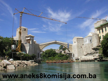
In 1992 the parapet of the Old Bridge was pierced by an artillery projectile at one point very close to the approach on the right bank of the Neretva on the downstream side. On 9 November 1993 the bridge was completely destroyed, falling into the Neretva, following sustained artillery attacks. That same year extensive damage was inflicted on the Halebija and the čardak beside it, on the right bank, and the Tara tower on the left bank was partly damaged (Urban Institute for the Protection of the Cultural, Historical and Natural Heritage of Mostar).
The complex of the Old Bridge continued to serve as a crossing over the river Neretva, thanks to the use of a temporary footbridge, even after it was destroyed. A suspension footbridge was installed after its destruction. Concrete foundations were poured on the left and right banks on the top of the wing walls as counter-weights for the cables of the suspension bridge. In early 1995 this footbridge, now badly damaged, was replaced by another suspension footbridge. In spring 1998 this footbridge was dismantled and replaced by a metal structure with a wooden footway. This was set a few metres upstream from the Old Bridge so as to free the wing walls and abutments of the bridge for reconstruction works. In December 1999 the footbridge was swept away by the Neretva in spate, after which a new metal structure suspended from cables was installed at the same spot.
In 1998 work began on the renovation of the historic core. That same year, Bosnia and Herzegovina nominated the Old Town in Mostar for inclusion on the World Heritage List. Ever since then there has been intense activity on the renovation of the historic core and individual monuments of the architectural heritage throughout the town. In 1999, agreement was reached in Washington between the Government of Bosnia and Herzegovina, the City of Mostar and the World Bank on key documents defining a project to renovate the Old Bridge and Old Town. Under the terms of this agreement, UNESCO was to provide the expert verification of the works on the renovation of Aga Khan Trust for Culture & World Monuments Fund (AKTC&WMF) was to manage the improvement of the neighbourhood, provide technical documentation for the component of the renovation of monuments, and provide a planning service for the historic town, as well as working on strengthening the required institutions in Mostar (City of Mostar, 2001, p. 2).
The reconstruction of the Old Bridge began, under the auspices of UNESCO, on 29 September 1997. The rehabilitation plan provided for the reconstruction of the Old Bridge, which had suffered more than 70% war damage, in order to restore it to its condition prior to being destroyed, the complete restoration of the Herceguša, Tara and Halebija towers with parts of the fortifications, the reconstruction of the Sultan Selim masjid and other buildings within the complex. The rehabilitation plan for the complex provided for each individual building use to be integrated through a unified programme run by the relevant authority. In the part of the complex on the left bank of the Neretva, the introduction of cultural facilities and cultural-religious use for the Sultan Selim masjid was provided for. In the part of the complex on the right bank, the introduction of cultural and catering facilities was provided for. In the implementation of the programme, the Municipality undertook to meet the technical standards of UNESCO's International Committee of Experts and the method of implementation run by the World Bank through the Project Coordination Unit (PCU) (Regulatory plan for the preservation and development of the Old Town in Mostar, 2001, p. 24). The Project Coordination Unit of the City of Mostar, department of urban administration, was charged with organizing and overseeing the rehabilitation and restoration of the Old Bridge complex and the infrastructure in its immediate environs.
At the end of 1997 and beginning of 1998, the SFOR Hungarian battalion assisted HIDEPITO company of Budapest in lifting the stones of the Old Bridge from the Neretva. The stone that was removed was stored on a plateau (a metal structure with wooden surface) located about 50 metres downstream from the bridge, on the right bank of the river (Main project for the reconstruction of the Old Bridge in Mostar, technical description, p. 4, 2003). Since it was impossible to rebuild the bridge using the original stone, it was decided to do so by facsimile method (making an identical copy of the monument based on surviving documentation). Research works consisted of geological studies, a survey of the abuttments and a pathological analysis. The analyses and findings of these works were set out in the final report. The report on the stone covered the findings of the study of the stone, old mortar and metals (iron and lead). As part of the rehabilitation plan for the complex, archaeological investigations were also carried out and archive documentation analyzed. Following these studies during 2002 and 2003, the historical evolution of the site can be divided into several stages:
Ÿ in about 1444 there were towers on both sides of the Neretva: on the right bank, the free-standing semicircular Halebija tower, and on the left bank the semicircular Tara tower with hexagonal fortifications;
Ÿ prior to 1452, the first wooden bridge was built, linking the forts. The bridge was built on two cantilever projections and a central «suspension» section. As support for the bridge, a semicircular, asymmetrical extension to the fortifications was built on the left bank, and a trapezoid extension to the plateau of Halebija tower on the right, with the wing walls of the bridge;
Ÿ between 1452 and 1566, the Halebija tower on the right bank was reinforced with a wall with walkway and merlons. The tower was raised in height by wooden merlons. At the same time, Tara was also raised in height, and a building was erected within the fortifications to accommodate the garrison. In 1522, the Sultan Selim masjid was also built for the garrison. The south-western part of the fortifications were reinforced and the Herceguša tower was built;
Ÿ in 1566, building works on the new stone bridge were completed. The projecting wing walls and abutments were built, reducing the span of the bridge, and a single-span arched bridge was built. A wooden guardroom or čardak was built above the new entranceway into the fort. There was a similar guardroom above the entranceway into the fort on the left bank, as well;
Ÿ between 1566 and 1690, the side walls of the fortifications were reinforced by building on a detached inside wall, and filling the space between with earth. The towers were altered on several occasions. Tara tower was raised in height again, and new stone merlons built on top. Halebija was raised in the same way, with new merlons and loopholes. Between 1680 and 1695, kapetan Halebija, from whom the tower acquired its name, altered it into a covered karaula (watchtower). He raised it in height and pierced a row of windows, turning the final storey of the tower into accommodation for the garrison;
Ÿ between 1690 and 1878, minor alterations were made to the facades of the towers, without any major building works. Between 1714 and 1716 Halebija tower became a dungeon in the lower storeys. The upper storeys were altered by the piercing of new windows. The walkway of the outer wall was raised as a ramp to the north door, and a new parapet was erected;
Ÿ building in the late 19th and 20th centuries: on the right bank, the fish market building was erected on the right bank, and a small storehouse on the left bank by the bridge; the masjid was rebuilt on the previous foundation walls. Between the masjid and Tara tower a new building used for residential and business purposes was erected (Peković, Milošević, Kovačević, 2002/2003., p. 82, 83)
2. Description of the property
OLD BRIDGE
The Old Bridge complex is the city’s most important cultural and historical feature, and indeed is one of the most important historical features in BiH as a whole.
On the basis of the position and structural design of the first suspension bridge, the remains of which were found during archaeological investigative works, the assumption is that prior to 1452 there was no other bridge where the present-day Old Bridge stands. The footings of the bridge on the left bank were probably built later, and set excentrically to the regular, symmetrical, polygonal fortress. These footings were built some ten years after the fortress, the masonry is very similar, and the same type of scaffolding was used. On the right bank, too, the walls supporting the original bridge are not associated in masonry with the Halebija tower.
The Halebija and Tara towers and fortifications were built in the mid 15th century. The towers, and the settlements alongside them to the left and right of the Neretva, were probably not initially linked by a bridge (the position of the towers suggests that they were built to fortify a narrow place for crossing the Neretva). It is possible that at first loads were transferred on this spot by a system of «cable cars» between the towers facing one another across the river. It was not long before a wooden bridge with a central suspended section was built at a level of 53.20 m above water level, above the high water point. This bridge remained in use for almost a century, until the new stone bridge was built.
To reduce the span, which was 35 m in the case of the wooden bridge, to 28.60 m for the new stone bridge, mimar Hayruddin built new wing walls and abutments at an angle to the longitudinal axis of the bridge. He used the existing walls and towers, partly filling them in and abutting against them. The approach to the new bridge was made over the previous approach to the wooden bridge. The side walls of the approach to the bridge were erected, with earth infill between them, and stone cobbles set in a thick layer of red earth and lime (Peković, Milošević, Kovačević, 2002/2003, p. 81).
Little is known of the building of the bridge; all that has been preserved in writing are memories and legends and the name of the builder, Hayruddin. Even now, when parts of the bridge have been extracted from the Neretva and all the component parts studied, it remains a mystery how the bridge was built, and certain associated technical issues are also a mystery: how the scaffolding was erected, how the stone was transported from one bank to the other, how the scaffolding remained sound during the long period of building. As a result, this work can be classed among the greatest building works of its time (Peković, Milošević, Kovačević, 2002/2003, p. 82)
As Katib Ćehaja recalled, the main problem faced by mimar Hayruddin, the architect of the bridge, was erecting the scaffolding for the arch of the bridge without foundations in the bed of the fast-flowing river. Instead of foundations, he decided to make abutments from limestone linked to wing walls along the waterside cliffs. Measuring from the summer water level of 40.05 m, he erected abutments to a height of 6.53 m, and began to build the arch of the bridge from that height. The start of the arch was emphasized by a moulding 0.32 m. in height. The rise of the arch was 12.02 m. The difference in height between the starting point of the arch on the right and left abutments is 0.13 m. (PCU Mostar, PP presentation, 2003).
The abutments of the bridge are built of two types of stone: «tenelija» limestone, which allows for a fine finish and thin joints, and conglomerate, which has a coarser surface
and wider joints. Tenelija blocks were used to build the base of the abutments (below the string course), the spandrels of the abutments (at right angles to the axis of the bridge) and the edges of the abutments. The rest of the visible parts is mainly of conglomerate. In certain places, though in very small quantities, solid limestone is also built into the buttresses.
The masonry of the abutments was worked in two parts: first, the fine-finished outer part was made of better quality stone with a depth varying from approx. 3 m at the base to 0.5 m at the top (the part built of tenelija and conglomerate), and a second part consisting of an infill of poorer quality stone used to bond the outer section of the abutments and the lateral basal rock, filled with conglomerate and lime mortar (Main project for the reconstruction of the Old Bridge in Mostar, Technical description, p. 2, 2003).
The wing walls of the bridge, which join the abutments on the upstream and downstream side, are an extension of the abutments. At a certain angle, they protect the parts of the bank on which the bridge rests from the force of the water, and rise to the level of the string course of the bridge. These walls are also set on the natural rock base, but the masonry technique used is not the same as that of the bridge itself, so that they have probably been rebuilt or added to at a later date. This is particularly noticeable on the wing walls by the left bank, where the inscription recording the repairs to the towers and bridge was mounted (Čelić, Mujezinović, 1969, pp. 190-194). Following the destruction of the bridge during the war, these walls were damaged, with some parts either damaged or missing, and there was a luxuriance of vegetation above the walls (Main project for the reconstruction of the Old Bridge in Mostar, Technical description, p. 2, 2003).
The arch of the bridge was made of local stone known as tenelija. The shape of the arch is the result of numerous irregularities produced by the deformation of the intrados (the inner line of the arch). The most accurate description would be that it is a circle of which the centre is depressed in relation to the string course. The arch began at the level of the string course (which is at 46.84 m above water level on the right-hand side and 46.72 on the left). On the north (upstream) elevation, the span was 28.71 m, and on the south (downstream), 28.68 m. The actual arch of the bridge consisted of:
Ÿ the barrel, composed of 111 rows of arch stones, with a total width of 3.95 m and average depth of 0.8 m. Each row is composed of 2 to 5 cut stones, with some pieces exceeding 2 m in size, or 3.23 m in the buttresses. The stone blocks were joined by metal clamps and nails set in three directions. An iron nail was set into each piece of stone, liquid lead poured over it, and then joined with clamps to the next piece of stone. The height of the barrel is level with the height of the spandrel arch;
Ÿ ribbed structures to provide rigidity, with two cavities on each side of the rib, acting as relieving voids. The walls are set at a width of approx. 80 cm on each side, thus avoiding the use of infill of heavy quarry stone and earth that would have put too much weight on the structure of the barrel. There is a degree of asymmetry in the average diameter of these cavities, with the upstream cavity 20 cm wider than on the downstream side. Alongside the right bank, there is a horizontal cavity above two parallel arched cavities, which is absent from the other side. These cavities were discovered during conservation works undertaken after World War II;
Ÿ masonry infill consisting of lime mortar and rough pieces of tenelija;
Ÿ the slab-like cladding at the top of the reinforcing rib;
Ÿ the base for the roadway (a layer of bauxite with the average depth of 0.2 m, two layers of mortar, one above and one below the bauxite layer, each with an average depth of 0.2 m), and the carriageway itself, made of limestone;
Ÿ the lower string course on the extrados (outer line of the arch), joined by clamps;
Ÿ the spandrel walls of the voussoir, which are not joined, but merely rest on the lower string course. This emphasized decorative string course is a transition on the facades from the arch to the spandrel walls, and follows the line of the arch. The string course is moulded and projects out from the spandrels by 15 cm, and is also 15 cm in height;
Ÿ the spandrel walls, also made of substantial tenelija blocks laid in markedly horizontal courses that extend in part onto the wing walls of the bridge, are set at the level of the forward line of the string course;
Ÿ the upper string course, which rests on the top of the spandrel walls and follows the grade line of the bridge. This string course is moulded in the same way as the one above the arch, but is thicker – from 20 to 24 cm. This one too projects forward from the spandrel wall by 14 cm;
Ÿ the parapet, made of tenelija, attached to the upper string course by nails and clamps linking the stone components of the parapet (Main project for the reconstruction of the Old Bridge in Mostar, Technical description, p. 3, 2003).
On the right hand side the bridge is partly built up on the spandrel walls to make the grade line slightly less steep. Three layers of cut stone blocks were to be seen at the end point of this built up section, arching in wedge-shaped form towards the middle, with their horizontal joints occupying a position parallel to the original grade line of the bridge. This is presumably the result of later interventions.
The grade line of the roadway falls away steeply from the centre towards the right and left banks. At its highest point it is 60.39 m above the normal water level, which means 20.34 m above the summer water level, falling away to 57.24 m on the right and 57.05 on the left hand side.
The roadway over the bridge has a korkaluk or parapet on either side, made of stone slabs with a thickness of 23-25 cm and a height of 94.50 cm. The parapet is fixed to the terminal string course level with the spandrel walls. The parapet leans slightly outwards towards the top.
The roadway over the bridge is paved with regular stone slabs, some large and some smaller, of hard white limestone, with transverse steps making it easier to cross. The stone is densely packed with mortar, so that very little water could penetrate into the structure itself. The transverse steps do not extend all the way to the parapet, so ensuring that water runs off more quickly. Beneath the paving is a layer of about 15 cm of crushed stone set in a mortar made of red earth and lime. This layer rests on a causeway about 15-20 cm thick over a layer of hard quarry limestone set in a sand and lime mortar. This bottom layer rests on the large stones with which the cavities are vaulted over. The date on which the wrought iron guardrail was added to the parapet is not known.
At the very foot of the bridge there were guardrooms on both sides, with gatehouses beneath. The guardroom on the left bank was demolished at the end of the Ottoman period; before the war there was a guard tower on the right bank, in which there was a café (Hasandedić, 1980, p. 122).
When the Old Bridge was built, the first mains water pipe from Radobolja to the left bank of the Neretva was laid across it. This first water main consisted of wooden pipes; the second, laid in 1629/30, consisted of earthenware pipes (Pašić, 1989, p. 68).
The use of carts crossing the stone steps of the Old Bridge compelled the Austro-Hungarian authorities to cover the entire structure of the bridge with sand and soil. This created another stratum over the bridge, raising the level of the roadway, particularly to the east, and the difference in height between the bridge approach road and Podkujundžiluk was overcome by a retaining wall on which a short curved flight of steps was later built. Raising the level of the bridge approach road forced those building the shops on the left bank by the Old Bridge following the destruction by fire of the ćepenak shops (with horizontally hinged front flaps) in 1878 to erect them to a considerably higher level than before. In addition to these works, the access to the old part of town around the Old Bridge altered in appearance in the latter years of the 19th century. In 1894 the City Council resolved to build a metal bridge over the Radobolja at Šemovac. The works were completed in 1896, and the entire area was raised by about 5 m, making it possible to lay a street from the parish church of SS Peter and Paul to the Old Bridge and to erect modern buildings along the street determining the size of the future street, which has remained the same to this day. In 1894 the City Council also resolved to build a metal bridge to replace the tumbledown Oručević bridge below Jusovina, which led to this area too being raised (Miletić, 1997, pp. 19, 161, 162).
According to information from the Technical Description of the Main project for the reconstruction of the Old Bridge in Mostar, the condition of the bridge in April 2001 was as follows:
Ÿ the abutment walls of the bridge, badly damaged by artillery strikes, were further damaged by frequent floors, with the result that they had structural and surface cracks, some of which had appeared even before the bridge was destroyed. Most seriously damaged were the walls on the north-eastern side, where there were visible cracks (one of them used as access to the interior cavity) from shelling, while the entire surface of the wall was damaged in several places;
Ÿ there was constant damage to the wall joints from flooding, rain, temperature fluctuations etc., which left the contours of the stone blocks very exposed;
Ÿ within the eastern abutment, a cavity was discovered on the northern side, recorded during research works carried out by the Conex-Yeralti Aramacilik joint venture. The discovery of this space, measuring approx. 2.5 x 7.8 x 6.6 m, called for particular care to be taken during the reconstruction of the bridge, particularly during work on the barrel and the dismantling of the concrete blocks at the top of the left-hand abutment;
Ÿ a few remains of the arch of the bridge (some stone blocks, with some components of the spandrel walls of the arch and the string courses) could be seen on the walls of both abutments. These remaining sections of the bridge were in critical condition, hanging over the Neretva (some pieces of the arch string course were unstable and at constant risk of falling into the water);
Ÿ some parts of the carriage-way at the top of the abutments were damaged and covered with karst, and vegetation was growing in some places. Blocks of reinforced concrete had been laid at the top of both abutments as the foundations for the first footbridge;
Ÿ Tara and Halebija towers, as well as the neighbouring buildings, were damaged during the war, and also showed damage resulting from weathering and age, which further exacerbated the condition of these buildings. The badly damaged remains of walls were visible, and the floor and roof structures were completely destroyed, as was the interior infrastructure network;
Ÿ the stones of the bridge that had fallen into the Neretva when it was destroyed had been removed from the river and laid out on a platform, measuring 13.0 x 26.0 m, with a wooden surface, at a height of 47.85 m above water level. The quantity of stone extracted and set out on the platform amounted to about 16% of all the stone components of the bridge, of which 36% were the load-bearing elements of the arch. Two large blocks of cut stone were left not far from the bank, being too heavy to lay on the platform. One of them consisted of five and the other of seven courses of wedge-shaped stones from somewhat below the string course, part of the spandrel wall of the arch and masonry infill;
Ÿ the area in the immediate vicinity of the bridge was in a state of total neglect;
Ÿ piers and load-bearing cables, as the basic structure of the new footbridge, had been set up on the north side. This bridge was some 8 m to the north of and parallel to the axis of the destroyed bridge.
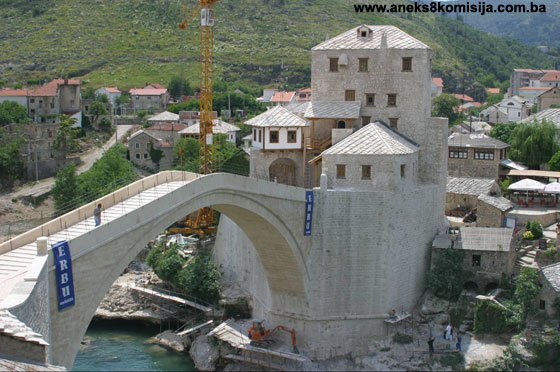
Works on the rehabilitation of the Old Bridge began in 2002. All the rehabilitation works were carried out according to the project documentation of the main project drawn up by General Engineering of Florence (Italy) under the project reference T.D.1/03. The review of the main project was carried out by Infinitinet d.o.o. Mostar. The contractor for the building works on the Old Bridge was ER-BU CONSTRUCTION & TRADE COLLECTIVE COMPANY of Ankara (Turkey), the successful bidder in the international tender. The chief supervision of the execution of the works on the Old Bridge was carried out by Omega Engineering, d.o.o. Dubrovnik/Mostar.
All the works on the reconstruction and renovation of Tara and Halebija towers and five buildings located by the Old Bridge were carried out according to project documentation drawn up by Omega Engineering-a d.o.o. Dubrovnik/Mostar, which also supervised the execution of the works. The contractor for the works on the towers and surrounding buildings was a Bosnia and Herzegovina joint venture company (G.P. Građevinar Fajić d.o.o. Mostar, HP Investing d.o.o. Mostar i Karadrvo d.o.o. Kiseljak).
The infrastructure project (renovation) in Old Town is being run by the City Authority of the City of Mostar.
Works on the Old Bridge, as set out in the rehabilitation project, entailed the reconstruction of the bridge, more than 70% of which was destroyed or damaged by war action, in order to restore it to its condition prior to suffering the damage. Since this is a high value monument, the project, respecting the original condition, retained certain features not in conformity with contemporary legislation, such as the architectural barrier and projection from damage to the walkway of the bridge with grade line and steps (Main project for the reconstruction of the Old Bridge in Mostar, Technical description, p. 2003). The rehabilitation project consisted of several different procedures relating to its implementation in practice: conservation and preservation, interventions to repair and replace individual parts, the erecting and dismantling of temporary structures, and reconstruction works. The stone used to reconstruct the arch of the bridge was taken from Komos in Opine, close to Mostar, where the quality control of the stone and binders was also carried out.
Renovation and repair works on Tara and Halebija towers, under the terms of the rehabilitation project for the complex, called for the restoration of the towers to their condition prior to suffering war damage, which included clearing the outer walls of vegetation; structural consolidation of the walls by injection (Tara tower) with a mixture of lime milk and filler; restoration works on the rehabilitation of the stone ornamentation; the traditional treatment of load-bearing timber structures and of the structure and composition of the walls; restoration works on the existing timber structure; the reconstruction of missing stone components of the tower using stone with similar characteristics with lime mortar as binder; working the stone by hand in the traditional way; remaining final artisanal works on the woodwork, metal reinforcements, building, plastering; laying a wooden interfloor structure so that the position of the load-bearing timber beams corresponds with the remains of the sockets for the beams found in the structure of the walls; mounting vertical access in the form of wooden stairs; making all timber elements of hand-finished oak using traditional jointing methods; the load-bearing structure of the roof also of timber, clad with stone slabs; all doors and windows restored to their original form and appearance in line with the remains found; building chimneys were they were formerly located; floodlighting the towers with interior and exterior floodlights (www.oldbridgetowers.com)
As part of the rehabilitation project, archaeological investigations were conducted during 2001-2002, as the basic archaeological investigations within the complex of the two towers, and during 2002-2003. The investigations were conducted on the area below the approach roads to the bridge itself. Their purpose was to gather new information on the date of construction and location of the older wooden bridge and on the early stages of development of the complex as a whole. Methodologically, these investigations were an example of trial stratigraphic investigation taking into consideration the chronological development of the site. The method of investigation was based on the excavation of strata one by one.
The most important find of these archaeological investigations was the remains of the mediaeval wooden suspension bridge with chains, but with no piers. A sketch by Professor Gojković showing its appearance was proven by the finds to be accurate. The channels of thirteen wooden beams with nails were found, as well as a piece of the original timber, which was submitted for analysis. On the left bank, the channels of timber beams with nails were also found, together with a metal cannon-ball (PCU Mostar, PP presentation, 2003).
In addition to these findings, a number of movable finds were made during the archaeological excavations. Ninety-two pieces of pottery from the post-mediaeval era were found on the left bank, all made on the potter's wheel, which can be divided into fine and coarse pottery. The fine pottery is smooth, pale yellow or brown in colour, with a decorative band at the neck or upper part of the body; the coarse pottery is brown, somewhat rough, and lacks decoration. These pottery finds include 19 Turkish pipes, most of which were intact. These were made in a mould, were mostly dark red in colour, and were decorated predominantly with impressed dot-like rhombs, impressed ornamental bands on the pipe or base, and herring-bone band at the edge of the base. Other finds included four coins (an Austro-Hungarian silver coin and copper coin and two Venetian copper coins), a mediaeval helmet, four stone cannon-balls and iron nails belonging to the wooden structure of the suspension bridge. While the site was being cleared beyond the excavations, three finds were made (part of the acroteria of an antique sarcophagus, the late antique upright of a bifora and part of a Turkish tombstone) (Peković, Milošević, Kovačević, 2002/2003, p. 68). The oldest find dated from the 15th century. All the archaeological finds have been fully documented (every piece found was entered in an inventory, described on the form for pottery, and drawn to a 1:1 scale). The movable finds were sent to Croatia for restoration (the metal items to the Museum of Coratian Archaeological Monuments in Split, and the wooden items to the Institute for Restoration of Croatia). After treatment these items will be returned and housed in the future archaeological museum (Reconstruction of the Old Bridge – Mostar, 2003). The intention is to display these items in the newly-discovered premises beneath the approach to the Old Bridge.
After completion of the archaeological works behind the abutments of the bridge and the removable of the remains of the bridge by the abutments, new evidence of the structure of the bridge came to light, which had not been available to the project designers prior to the completion of the archaeological investigations. This new evidence was as follows: the arch and triangular walls were separated by thick mortar pointing from the walls of the abutments, and the joins of the arch and triangular walls were much better than those of the rest of the bridge. This led to changes to the computational model of the bridge in the buttress area (Main project for the reconstruction of the Old Bridge in Mostar, Technical description, 2003).
The fact that the archaeological excavations had led to the discovery of new information had the following impact:
Ÿ changes to the treatment of the approach slabs to the right and left as compared with the project's proposed treatment for repairs to Tara and Halebija towers, because of the archaeological finds to be on display;
Ÿ the remains of the suspension bridge referred to in the Dubrovnik Archives for 1452 dictated the treatment of the reinforced concrete structure above the archaeological site, while will make it possible to restore all the approach strata of the road structure as proposed by the reconstruction project for the Old Bridge;
Ÿ a new project design was agreed with UNESCO experts and accepted by them with the aim of not undermining the original idea of a facsimile reconstruction of the Old Bridge and towers and in order to ensure that the archaeological finds could be properly presented and to increase the historical, artistic and archaeological value of the site (letter from PCU to Committee, 29 December 2003).
Following these investigations, work began on the scaffolding and the arch of the Old Bridge. The scaffolding consisted of 4 triangular spatial grids, steel transverse beams, five rows of heavy steel scaffolding on the transverse beams, timber centring and timber transverse beams. The supports for the scaffolding were two temporary reinforced concrete piers with cantilevers to reduce the span of the grid. The piers were attached to the banks with pre-stressed geo-anchoring. The design and mounting of the scaffolding were by GP ŽGP d.d. Sarajevo.
The renovation of the Sultan Selim mosque, which constitutes with the bridge a single functional entity (the bridge was the minaret of the mosque), the approaches to the bridge and the buildings in the immediate vicinity of the Old Bridge on both banks of the Neretva (the town walls, shops and storerooms within the Mostar čaršija, mills) was also carried out as part of the renovation of this complex.
TARA AND HALEBIJA TOWERS
The Halebija and Tara towers and fortifications were built by the aristocrat Radine in the 1440s. The towers and the settlements alongside them on the right and left banks of the Neretva were probably not initially linked by a bridge (the position of the towers suggests that they were built to fortify a narrow place for crossing the Neretva) (Peković, Milošević, Kovačević, 2002/2003, p. 81).
In 1957 extension investigations were carried out in the Halebija tower on the right bank of the Neretva. In the course of these works the mortar on the inner side of the tower was removed, following which the original height of the floors was ascertained and the location of the old stairway was found. On the topmost floor a line of defensive prongs was observed, suggesting that the present-day roof of the tower and its ultimate appearance were of somewhat later date than the rest of the building. When excavating deep in the base of the tower the presence of another three storeys beneath the present-day ground floor level was discovered. The assumption is that these were used as a prison, which may be corroborated by information in old documents on this part of Mostar. In addition, two large cracks were found and made good. Following these investigative works, a project to renovate the tower was drawn up, which suggested repairing the existing parts of the building, building new floors, modernizing the building by introducing utilities installations and sanitation, and changing the use of the building to an exhibition space or gallery complex (Findrik, 1957, p. 183).
The central fortress on the left bank, Tara tower, dominated the fortifications in shape, size and position, and defended it from the east. In ground plan it is semicircular. The west facade is flat, with an irregular semicircle facing east, to defend the approach to the bridge. The walls are about 3 m thick on the first three storeys, narrowing in the subsequent storeys to 2.5 m thick, while the merlon wall with loopholes is 0.9 m thick. They are built of untreated stone of irregular sizes in a thick layer of lime mortar with aggregate of river sand. The stones are not laid in courses. The only cut stones are those of the quoins, binding stones appearing at both angles of the tower. These are of large stone blocks laid alternatively and bonded to the wall mass.
The entrance to the tower is on the west facade and is reached by a steep access stairway. Two windows and part of the much rebuilt merlon wall at the top survive on this facade. On the east facade there are no apertures other than those of the merlon wall.
The remains of several stages of construction are visible on the east facade. On the southern part of the semicircular facade, where it joins the west facade, the remains of cut stone consoles have survived. These were double regular-cut stone consoles measuring about 26 x 36 cm, at a distance of 60-80 cm apart. The remains of four pairs of consoles of the same type are also visible on the northern part of the semicircular facade. These stone consoles supported the projecting machicolations of the tower (Peković, Milošević, Kovačević, 2002/2003, p. 76).
This mediaeval style of fortification helped to defend the foot of the tower, by making it possible to observe and defend it when the enemy drew near to the foundations of the tower. There were machicolations only on the semicircular part of the tower. There are no visible remains on the flat part, which was within the fortifications so that there was no need to defend it from that side. There were small arches between the double stone consoles, on which the merlon wall was built. There are minor differences in the masonry and type of mortar at about 80 cm above the consoles, where the floor level of the tower of that time was.
This level corresponds to the base of the lowest aperture in the west facade by that corner of the tower. A walled-up door is now visible there, later turned into a small window. There is a door on Halebija at the same relative height to the surviving stone consoles. This opening, at the same relative height on both Halebija and Tara, was the entrance to the topmost defence storey of the tower. The walls of both Tara and Halebija are more than 3 m thick up to the base of these doors.
This stage of construction of the towers can be dated to the first half of the 15th century, when the fortress was built to protect the first suspension bridge on that spot; there is reference to it in archive documents of the period.
Very similar types of fortress with the identical ground plan topped by a semicircular tower are to be found in the ramparts of Dubrovnik. The form is strongly reminiscent of the castle of St James in Dubrovnik, built somewhat earlier than the Mostar fort. The link with this region by means of the Dubrovnik trade routes and the on-going work of Dubrovnik builders in nearby Počitelje support the hypothesis that this model of fortifications was adopted from and built by Dubrovnik builders.
Tara tower was built onto on several occasions. The earliest stage of construction of this tower is a Renaissance fortress with cantilevered merlon wall. Round holes in the stone walls are arranged at regular intervals 3 m above the top of the stone consoles on all the facades, including the flat facade. The remains of wooden beams survive in some of these holes. The same traces are visible on the insider of the tower. In the central part, the beams run parallel, whereas to the south and north they are set radially. The holes in the stone walls have a diameter of 26-40 cm and formerly held round wooden beams which projected through to the outside. These are the remains of a čardak, a wooden platform on which the projecting wooden top section of the tower was built.
To build on to this tower, the previous machicolations had to be demolished and the stone consoles supporting them cut away. A projecting merlon wall was built, largely of timber in line with the Ottoman style of fortress building. Whole beams extending from one end of the tower to the other were used for the platform, making it possible to organize the defence of the foot of the tower. This addition can be dated to the late 15th or early 16th century. The reason for the reconstruction could be that it was partly destroyed while the town was being taken. The bridge which it protected remained in use until the new stone bridge was built in 1566 (Peković, Milošević, Kovačević, 2002/2003, p. 79).
The tower was altered once again, when the čardak was removed, the wall was raised by a little over 4 m, and a stone merlon wall 90 cm thick was erected. The merlon wall has apertures 40-50 cm wide, and had narrow loopholes in the raised sections. A large part of the merlon wall of the semicircular part of the tower has survived, but on the flat west facade it has been partly rebuilt. This can be dated to the Candian wars, when major alterations were made to Halebija tower as well. All the interfloor structures of the tower were of round wooden beams, as evidenced by the remains of the sockets in the walls.
During rebuilding following the explosion of the power chamber in Tara (the year when this was carried out, recorded on a stone plaque built into the vault, AH 1237 – 1821-1822 CE; the plaque also refers to Kemal Zade Mustafa), a barrel vault was built on the final interfloor timber structure. This vault was rather clumsily mounted; it is rectangular in form, and was erected on the semicircular ground-plan of the tower. These two geometrical forms, the rectangle on a semicircle, do not fit, so that the vault partly «hangs» in the tower. With this addition, the tower had already lost its direct defensive function, because the town centre with a defensive wall had already been built around it. Once the vault was built, the merlon wall became completely impassable. The tower was then used as a powder magazine, and the reason for building the vault was to provide better protection from precipitation and wind (Peković, Milošević, Kovačević, 2002/2003, p. 80).
Halebija tower on the right bank of the Neretva is similar in form to Tara, with an almost identical ground plan. Surviving traces of the building stages of the tower are identical in the early stages to Tara. This shows that the two banks of the river were developed at the same time and that the intention was to build a Renaissance fortress on the two banks, linked by a suspension bridge.
At the northern angle of Halebija, part of the outer wall was destroyed by war action. The remains of cut triple stone consoles are visible on this part of the semicircular wall. They are of the same size and distance apart as those of Tara, and the relative height of the consoles and the entrance door to the tower is also the same. There are no visible remains on the rest of the semicircular facade, since they were removed during alterations.
The first stage of development, dating to the first half of the 15th century, is the semicircular tower with machicolations – unlike Tara, this has triple stone consoles.
During excavations, walls were found on the right bank, between Halebija and the river, which were the abutments of the suspension bridge. The wall found in a trial trench on the right bank below the wall of Halebija was not joined by masonry to the tower, suggesting it was built on later. It was set at an angle (north-west/south-east) to the wall of the tower, and is 0.85 m wide. The trench was not sunk to the base of the wall, so that the depth of the foundations is not known. This was part of the abutment of the wooden suspension bridge on the right bank (Peković, Milošević, Kovačević, 2002/2003, p. 77).
At the bottom of a trial trench by Halebija tower, alongside the entrance to the fortress, at a depth of 3.5 m below the present-day road, the cobbles of the approach road to the wooden bridge were found. The height of this road was 52.89 m above water level. It sloped slightly down towards the river and was at almost the same height as the wooden walkway of the bridge, which was found on the left bank at a height of 53.17 m above water level.
A trench was dug alongside the wall built to reinforce the foot of Halebija, its outer wall, which is 2.3-1.4 m wide and had a narrow walkway 80-90 cm wide, with merlons (the part of the parapet between two loopholes) 80 cm wide.
The erection of this reinforcing wall meant the removal of the triple stone consoles and merlon wall of the tower, which was raised in height at that time. The reinforcement by a lower outer wall was carried out before the construction of the new bridge, probably immediately after the fortress was taken by the Ottomans, in the second half of the 15th century. This wall was laid on the approach road to the earlier bridge, and had regular-cut stone edges to be more visible, but these were buried when the new approach road to the bridge was made in the 16th century.
The remains of small circular holes for scaffolding, typical of the first stage of building of the towers and fortifications on both sides of the river, were found on this outer wall, the wall of the abutments and the lower parts of Halebija.
The wooden bridge remained in use for almost a century following the Ottoman conquest of the fortress. The construction of the bridge in the 16th century led to minor alterations on the right bank. The abutment walls of the bridge were built, increasing the surface area of the trapezoid plateau between the tower and the river. The level of the approach road to the bridge was raised, and new cobbles laid. The wall in which the entrance door was built was raised, and a wooden watchtower or čardak erected above it.
The upper storeys of Halebija were rebuilt more than once. Like Tara, it had the later addition of a wooden čardak. Few traces of this wooden čardak have survived. In the interior, the sockets are visible in which the wooden beams were set.
The tower probably underwent major alterations during the Candian wars (1645-1660). It was raised in height, and topped with a merlon wall with loopholes (Peković, Milošević, Kovačević, 2002/2003, p. 78).
The next alterations to Halebija are associated with the name of kapetan Halebija, from whom the tower acquired its later name among the people. It was he who adapted the tower between 1680 and 1695, turning it from a mediaeval tower with merlon wall and few openings to a Turkish covered karaula or watchtower. The gaps between the merlons were filled in, the wall was raised by about 1.5 m above the former level of the merlon wall, and new small loopholes were pierced; a row of arched windows was pierced in the walls of the last two storeys to create accommodation within the fortress for the garrison guarding the bridge day and night.
Not long after that, Halebija became a dungeon, the idea of Mustafa-paša Čelić (1714-1716). The upper storeys were altered to become more suitable for residential use. Extra windows were added, fireplaces were built on all three storeys, two chimneys were added to the new roof structure, and a spacious «divanhana» was laid out on the topmost storey with a large ornamental stone fireplace. One of the windows to the north of the tower was opened up to make a door leading to the walkway of the outer wall. Since the previous walkway was lower than the level of the door by 3.5 m, a new one was built as a ramp to overcome the difference in level, beginning at the level of the entrance to the čardak and sloping up around the semicircular section to reach the base of the newly-pierced door. A new parapet was built around the new walkway at the same time (Peković, Milošević, Kovačević, 2002/2003, p. 79).
With the start of Austro-Hungarian rule in the second half of the 19th century, major alterations were carried out within the fortifications, particularly on the left bank. The entrance to the fortress on which there had been a čardak similar to that on the right bank was demolished, and the cobbled approach road laid there, so as to level the road and make it possible for traffic to cross the bridge. The masjid was thoroughly rebuilt, with new alls above floor level. To the west, by the bridge, a small storeroom was built. There was another storey above the ground floor, with a tufa barrel vault. A two-storey building was erected between the masjid and Tara, with business premises on the ground floor and flats on the first floor. (Peković, Milošević, Kovačević, 2002/2003, p. 80).
At the end of the 19th and the beginning of the 20th century, the fortress lost its military importance, and all that was maintained was the crossing over the Neretva. Apart from the rebuilding of the masjid, two further buildings were erected at this time: a storeroom at the very edge of the bridge, abutting onto the west wall of the Sultan Selim masjid, and a combined residential and business building between the masjid and Tara tower. (Peković, Milošević, Kovačević, 2002/2003, p. 77).
SULTAN SELIM YAVUZ MASJID
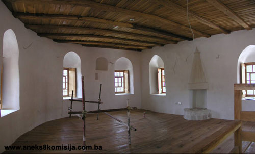
Close by the Old Bridge stands a small masjid built during the reign of Sultan Yavuz Selim I (1512-1520), used primarily by the military guarding the bridge. The masjid has no minaret; the azaan was called from a stone at the top of the Old Bridge by the parapet on the south side of the bridge. The bridge thus served as a minaret.
The original appearance of the masjid, and the date when it was built, are not known with accuracy. The building was repaired on several occasions and thus lost almost all its original appearance. The last time it underwent major repairs was in 1882, as recorded on the inscription incised on a plaque above the entrance door; this tarih (chronogram) plaque is now kept in the Regional Museum of Herzegovina in Mostar.
The masjid building abutted in part on the existing walls of the fortress, which formed its foundation walls, while the other two foundation walls, west and south, were new and considerably narrower. Other than these foundation structures, there are no remains of the building dating from the first half of the 16th century. The present-day masjid was built in the late 19th century during the Austro-Hungarian period, when the original walls above floor level were pulled down and new ones erected (Peković, Milošević, Kovačević, 2002/2003, p. 76).
When the masjid was built, a basement was excavated below it, about 5 metres in depth, which was apparently used as a military store. In 1676, when the Barutana or powder magazine was erected close to the masjid, the basement was probably vacated and no longer used for its original purpose.
During the Austro-Hungarian period it had been the intention to build a domed mosque with a tall stone minaret here. A plan was drawn up, which shows that the mosque was to have been square in ground plan with the sides measuring 8.10 m; that it was to have had a large central dome and three small domes over the portico; and that there was to have been a stone minaret of octagonal section, 25 m in height, by the right-hand wall. This plan was drawn up in February 1903 by engineer Dragutin Kohle, and is kept in the Archives of Herzegovina in Mostar. By ruling no. 75.959/1 dated 13 May 1903 the Territorial Government for Bosnia and Herzegovina allocated the sum of 7,500 crowns «for the transformation of the Sultan Selim mosque by the Old Bridge according to the plan» (Archives of the Vakuf Commission in Mostar, act no. 248/1903). It is not known just why this building was not erected and for what purpose the funds were expended. The masjid had no vakuf, but was maintained from state funds. The masjid owned merely one storeroom in Hendek near the Old Bridge. The masjid is entered in the cadaster as 3140, c.p. 17/78, and occupies an area, including the portico, of 205 sq.m.
Fragments of paintings with stylized foliar designs in vivid colours and light strokes survive on the walls of the masjid (Zvonić, 2001, p. 32).
Above the entrance to the mosque, a text in simple naskh script records that the masjid was built to the orders of Sultan Yavuz Selim, and that it was renovated by the benefactor Hajji Mehmed. The year of this renovation is given as 1300 AH (1882-83 CE).
The Institute for the Protection of Cultural Monuments in Mostar began conservation and restoration works on the building a few years before the 1992-95 war. Two shops, built in the portico in 1924, were demolished. It was then that the basement was discovered beneath the masjid, although its existence had already been known in 1892 when works began on digging out the foundations for a shop by the left-hand wall (Hasandedić, 2000, p. 147-151).
During the war, in 1993, the roof and west wall of the building were destroyed. The rehabilitation project for the complex provides for the rehabilitation of the masjid as well, and its restoration to its original religious function as a mosque.
3. Legal status to date
The Regional Plan of the Republic of Bosnia and Herzegovina to 2002 lists the Old Bridge as a Zero category monument.
Pursuant to the law, and by Ruling of the National institute for the Protection of Cultural Monuments and Natural Rarities in Sarajevo, no, 734/50, of 1950, the Old Bridge in Mostar with its two towers was protected as a cultural monument.
Pursuant to the law, and by Ruling of the National Institute for the Protection of Cultural Monuments of NR BiH in Sarajevo, no. 02-647-3, of 1962, the Old Bridge in Mostar with its two towers was entered in the register of immovable cultural monuments as no. 153.
The Old Bridge and towers are on the Provisional List of National Monuments of the Commission to Preserve National Monuments, under serial no. 377.
The Federal Ministry of Regional Planning and the Environment, Federal Town Planning and Building Inspector, issued a Ruling (no. UPI/06-23-3-51/03, dated 9 July 2003), ordering the Mostar City Authority, Project Coordination Unit, as investor of the works, immediately to suspend works on the building/rehabilitation of the Old Bridge, and to recommence the works after procuring a building permit.
The Federal Ministry of Regional Planning and the Environment issued a Ruling (no. UPI/02-23-7-18/02, dated 14 August 2003), issuing approval for the rehabilitation/rebuilding of the Old Bridge over the river Neretva in Mostar (on c.p. 6460, c.m. Mostar II, and c.p. 4516, c.m. Mostar I, old survey), bordering c.p. 7/1, c.m. Mostar (new survey), Municipality Old Town Mostar. This approval was issued to the City of Mostar, Project Coordination Unit for building the Old Bridge in Mostar (PCU).
The Federal Ministry of Regional Planning and the Environment, Federal Town Planning and Building Inspector, issued a Ruling (no. UPI/06-23-3-33/04, dated 18 March 2004) ordering the Mostar City Authority, Project Coordination Unit, as investor of the works, immediately to suspend works on the building/rehabilitation of the Tara and Halebija towers of the Old Bridge in Mostar, and to recommence the works after procuring a building permit.
4. Research and conservation and restoration works
Ÿ 1952 – the National Institute for the Protection of Cultural Monuments carried out repairs to the bridge and towers, consisting of replacing the dilapidated interfloor structures of the towers, repairing the roofs of both towers, the guardhouse and fish market, clearing the bridge and its abutments of vegetation which was causing serious damage to the structure, repairing the cracks on the west abutment wall of the bridge, and renovating the half-timbered guardhouse above the western entrance to the bridge (Zdravković, 1953, p. 142-143);
Ÿ 1953 – the roof structure on part of the storeroom by the Old Bridge was studied;
Ÿ 1954 – a detailed analysis of the structure of the bridge was carried out (PCU Mostar, PP presentation, 2003);
Ÿ 1955 – the tower by the bridge was clad with slabs and adapted;
Ÿ 1956 – the foundations of the Old Bridge were repaired;
Ÿ 1957 – major research works were carried out on the tower on the right bank of the Neretva (Findrik, 1959, p. 183). Repairs to the foundations of the right-hand abutment of the bridge were carried out (PCU Mostar, PP presentation, 2003);
Ÿ 1958 – leading and injecting on the Old Bridge; work to make good the tower on the right bank of the Neretva;
Ÿ 1963-1967 – repairs and conservation of the foundations of the Bridge (Krsmanović, Dolarović, Langof, 1967, pp. 5-12) and repairs to the barrel of the Old Bridge (Krsmanović, Dolarović, Langof, 1967, pp. 12-21);
Ÿ 1970 – replacement of parts of the arch (PCU Mostar, PP presentation, 2003);
Ÿ 1982 – research works carried out and the foundations of the Bridge again repaired (PCU Mostar, PP presentation, 2003);
Ÿ 1997 – the Institute for the Protection of the Cultural, Historical and Natural Heritage of Mostar, in association with UNESCO, drew up a plan for the protection of the monuments of the entire city of Mostar and the reconstruction of the historic quarter of the Old Town;
Ÿ 1999 – renovation of the Old Bridge and Old Town in Mostar, pursuant to an agreement between the Government of FBiH, the City of Mostar, the World Bank and UNESCO signed in Washington on 30 April 1999 (Regulatory Plan for the Preservation and Development of the Old Town in Mostar, 2001, p. 1).
5. Current condition of the property
An on-site inspection in June 2004 ascertained as follows:
Ÿ All works on the rehabilitation of the complex are in the final stage: laying cobbles on the approaches to the bridge, works to the interior within the buildings; the removal of the foundations of the scaffolding of the arch of the bridge is under way;
Ÿ On 19 June 2004 the technical approval of the bridge began, by the Federal expert committee, and technical approval of the towers is expected shortly;
Ÿ All works on the rehabilitation of the complex are due to be completed by 23 July 2004, when the formal opening of the Old Bridge and surrounding buildings is expected to take place.
III – CONCLUSION
Applying the Criteria for the adoption of a decision on proclaiming an item of property a national monument (Official Gazette of BiH nos. 33/02 and 15/03), the Commission has enacted the Decision cited above.
The Decision was based on the following criteria:
A. Time frame
B. Historical value
C. Artistic and aesthetic value
C.iii. proportions
C.iv. composition
C.vi. value of construction
D. Clarity
D.ii. evidence of historical change
D. iv. evidence of a particular type, style or regional manner
E. Symbolic value
E.i. ontological value
E.ii. religious value
E.iii. traditional value
E.iv. relation to rituals or ceremonies
E.v. significance for the identity of a group of people
F. Townscape/ Landscape value
F.i. Relation to other elements of the site
F.ii. meaning in the townscape
F.iii. the building or group of buildings is part of a group or site
G. Authenticity
G.i. form and design
G.v. location and setting
G.vi. spirit and feeling
G.vii. other internal and external factors
H. Rarity and representativity
H.ii. outstanding work of art or architecture
I. Completeness
I.i. physical coherence
I.ii. homogeneity
I.iii. completeness
The following documents form an integral part of this Decision:
- Copy of cadastral plan
- Copy of land register entry and proof of title;
- Photodocumentation;
- Drawings
Bibliography
During the procedure to designate the Old Bridge and towers as a national monument of Bosnia and Herzegovina the following works were consulted:
1953. Neidhart, Juraj and Čelić, Džemal, Stari most u Mostaru – arhitektonsko-urbanistička problematika konzerviranja i restauriranja mosta i okoline te korigiranje udaljenijih objekata, koji optički priparaju okolini mosta, (Old Bridge in Mostar – archictectural and town planning problems of the conservation and restoration of the bridge and surroundings and correction of more distant buildings visually part of the bridge surroundings) Naše starine I, Annual of the Institute for the Protection of Monuments of SR Bosnia and Herzegovina, Sarajevo, 1953.
1953. Zdravković, Ivan, Opravka kula kod Starog mosta u Mostaru (Repairs to the towers by the Old Bridge in Mostar), Naše starine I, Annual of the Institute for the Protection of Monuments of SR Bosnia and Herzegovina, Sarajevo, 1953.
1954. Kreševljaković, Hamdija, Stari hercegovački gradovi, (Old Herzegovinian towns) Naše starine II, Annual of the Institute for the Protection of Monuments of SR Bosnia and Herzegovina, Sarajevo, 1954.
1956. Mujić, Muhamed, Stari mostarski vodovod, (The old Mostar water main) Naše starine III, Annual of the Institute for the Protection of Monuments of SR Bosnia and Herzegovina, Sarajevo, 1956.
1959. Findrik, Ivan, Uređenje kule Starog mosta u Mostaru, (Making good the tower of the Old Bridge in Mostar) Naše starine VI, Annual of the Institute for the Protection of Monuments of SR Bosnia and Herzegovina, Sarajevo, 1959.
1967. Krsmanović D., Dolarović H., Langof Z., Sanacija Starog mosta u Mostaru (Repairs to the Old Bridge in Mostar), Naše starine XI, Annual of the Institute for the Protection of Monuments of SR Bosnia and Herzegovina, Sarajevo, 1967.
1969. Čelić, Džemal and Mujezinović, Mehmed, Stari mostovi u Bosni i Hercegovini, (Old Bridges in BiH) Veselin Masleša, Sarajevo, 1969.
1972. Četvrt stoljeća službe zaštite spomenika kulture i prirode u Bosni i Hercegovini, (A quarter century of service to the protection of cultural and natural monuments in BiH) Naše starine XIII, Annual of the Institute for the Protection of Monuments of SR Bosnia and Herzegovina, Sarajevo, 1972.
1974. Anđelić, Pavao, Srednjovjekovna župa Večenike-Večerić - postanak Mostara, (Mediaeval county of Večenike-Večerić) Journal of the National Museum of BiH in Sarajevo, new series, vol XXIX, Sarajevo, 1974.
1978. Dinić, Mihajlo, Zemlje hercega Svetog Save.(Land of herzeg St Sava) in Srpske zemlje u srednjem veku (Serbian lands in the middle ages), Belgrade, 1978.
1980. Institute for architecture, town planning and regional planning of the Faculty of Architecture in Sarajevo, Prostorni plan Bosne i Hercegovine; Faza «B» - valorizacija prirodne i kulturno-historijske vrijednosti, (Regional plan for BiH, Stage B: valorization of natural and cultural and historical values) Sarajevo, 1980.
1980. Hasandedić, Hivzija, Spomenici kulture turskog doba u Mostaru, (Cultural monuments of the Turkish period in Mostar) IRO «Veselin Masleša», Sarajevo, 1980.
1982. Regional Planning Institute - Mostar, Urbanistički plan Mostara,(Plan of Mostar) Sinteza, Mostar, 1982.
1984. Čelebić, Edin, Kulturne prilike u Mostaru krajem XIX i početkom XX vijeka, (Cultural circumstances in Mostar in the late 19th and early 20th century) Hercegovina 4, cultural and historical heritage magazine, Archive of Herzegovina, Mostar, 1984.
1984. Papić, Mitar, Školstvo u Bosni i Hercegovini (1918-1941), (Education in BiH 1918-1941) Veselin Masleša, Sarajevo, 1984.
1984. Ratković, Aleksandar, Srednjevjekovni Mostar i problematika njegovog istraživanja, (Mediaeval Mostar and problems of research) Naše starine XVI-XVII, Annual of the Institute for the Protection of Monuments of SR Bosnia and Herzegovina, Sarajevo, 1984.
1989. Pašić, Amir, Prilog proučavanja islamskog stambenog graditeljstva u Jugoslaviji na primjeru Mostara, Koliko je stara stambena arhitektura Mostara autohtona pojava, (Contribution to a study of Islamic residential architecture in Yugoslavia, the example of Mostar, to what extent is the old residential architecture of Mostar an indigenous phenomenon) doctoral dissertation, Zagreb, 1989.
1990. Andrejević, Andrej, Neimar Hajredin i njegov rad u Hercegovini, (Neimar Hayruddin and his work in Herzegovina) Hercegovina – cultural and historical heritage magazine, Archive of Herzegovina, Mostar, 1990.
1991. Kreševljaković, Hamdija, Izabrana djela II – Esnafi i obrti u Bosni i Hercegovini (1463-1878), (Selected Works II – guilds and trades in BiH 1463-1878) Veselin Masleša, Sarajevo, 1991.
1991. Kreševljaković, Hamdija, Izabrana djela III – banje, vodovodi, hanovi i karavansaraji, (Selected Works III – baths, water mains, hans and caravanserais) Veselin Masleša, Sarajevo, 1991.
1994. Pašić, Amir, Islamic Architecture in Bosnia and Hercegovina, Organisation of the Islamic Conference (OIC), Research Centre for Islamic History, Art, and Culture (IRCICA), Istanbul, 1994.
1996. Čelebi, Evlija, Putopis – odlomci o jugoslovenskim zemljama, (Travelogue – extracts on Yugoslav lands) Sarajevo Publishing, Sarajevo, 1996.
1997. Miletić, Karlo Drago, Mostar – susret svjetskih kultura, (Mostar – encounter of world cultures) Association of municipalities with Croat majority, Chief Secretariat of HDZ BiH, Mostar, 1997.
1998. PCU Mostar, Nomination for the World Heritage List, PowerPoint presentation, Mostar, 1998.
1998. Mujezinović, Mehmed, Islamska epigrafika Bosne i Hercegovine, (Islamic epigraphics of BiH) vol III, Sarajevo-Publishing, Sarajevo, 1998.
1999. A Joint Conservation Project of the Aga Khan Trust for Culture's Historic Cities Support Programme & The World Monuments Fund, Reclaiming Historic Mostar: Opportunities for revitalization, 15 Donnor Dossier for Conservation of the high Priority Sities in the Historic Core, New York - USA, Istanbul - Turkey, 1999.
2000. Ayverdi Dr. Ekrem Hakki, Avrupa'da Osmanli Mimari Eserlera Yugoslavya II, 3. kitab, Istanbul, 2000.
2000. Ratković, Aleksandar, Novi podaci o mostarskoj tvrđavi,(New facts on the Mostar fortress), Hercegovina 11-12 – cultural and historical heritage magazine, Archive of Herzegovina, Mostar, 2000.
2000. Hasandedić, Hivzija, Mostarski vakifi i njihovi vakufi, (Mostar's vakifs and their vakufs) Majlis of the Islamic Community Mostar, Mostar, 2000.
2001. City of Mostar, Municipality Stari Grad, The Aga Khan Trust for Culture, Geneva & World Monuments Fund, New York, Regulacioni plan očuvanja i razvoja Starog Grada u Mostaru, (Regulatory plan for the preservation and development of the Old Town in Mostar) World Monuments Fund, New York City, 2001.
2001. City of Mostar, Management plan Starog Grada u Mostaru – upravljanje, finansiranje, planiranje, intervencije, (Management plan for the Old Town in Mostar – management, finansing, planning, interventions) City of Mostar, 2001.
2001. Hadžismajlović, Vefik, Edmund Misera – gradovi i krajevi Bosne i Hercegovine na akvarelima 1880-1883, (Edmund Misera – towns and regions of BiH in watercolours 1880-1883) Bosniac Institute –Adil Zulfikarpašić Foundation, Sarajevo, 2001.
2001. Šarić, Salko, Likovna pozornica Mostara, (Mostar's art scene) Centre for culture, Mostar, 2001.
2002-2003. Peković Željko, Milošević Ante, Kovačević Nela, Arheološka istraživanja na mostarskim utvrdama u 2002. godini (Archaeological investigations on Mostar's fortresses in 2002), Hercegovina, annual for the cultural and historical heritage, nos. 8-19 (16-17), Mostar, 2002/2003
2003. City Institute for the Protection of the Cultural, Historical and Natural Heritage of Mostar, Rad Zavoda za zaštitu kulturno-historijskog i prirodnog nasljeđa Mostar u periodu od 1994. do 2003. godine, (Work of the Institute for the Protection of the Cultural, Historical and Natural Heritage of Mostar 1994-2003) brochure, Mostar, 2003.
2003. City of Mostar, The Old Town in Mostar – Management Plan, Mostar, 2003
2003. PCU Mostar, Probni projekat kulturnog naslijeđa – Rekonstrukcja Starog mosta u Mostaru, (Pilot project of the cultural heritage – Reconstruction of the Old Bridge in Mostar) PowerPoint presentation, 2003
2003. PCU Mostar, Reconstruction of the Old Bridge – Mostar, Newsletters 1-9, Mostar, May 2003
Institute for the protection of the cultural, historical and natural heritage of BiH, Centre for Heritage, Tradicionalni detalji sa objekata kulturno-historijskog naslijeđa u Bosni i Hercegovini (Traditional details from buildings of the cultural and historical heritage in BiH)
|