Status of monument -> National monument
Pursuant to Article V para. 4 Annex 8 of the General Framework Agreement for Peace in Bosnia and Herzegovina and Article 39 para. 1 of the Rules of Procedure of the Commission to Preserve National Monuments, at a session held from 20 to 26 January 2004 the Commission adopted a
D E C I S I O N
I
The historic site of the old Prusac fort is hereby designated as a National Monument of Bosnia and Herzegovina (hereinafter: the National Monument).
The National Monument is located on cadastral plot nos. 520 (upper fortress or citadel, bailey and moat with clock tower) and c.p. nos. 521, 522, 523, 524, 525/1, 525/2, 525/3, 525/4, 526, 527, 580/1,2, 581/1,2, 582, 583, 584, 585, 586 (road), 587,588, 589, 589, 590, 591, 592/1, 592/2, 592/3, 592/4, 593, 594 (road), 595, 596, 597, 598, 599 (lower fort) and c.p. no. 600 (road to lower fort from main gatehouse into the bailey and the citadel), cadastral municipality Prusac I, municipality Donji Vakuf, Federation of Bosnia and Herzegovina, Bosnia and Herzegovina.
The National Monument consists of the fortress, bailey, lower fort and movable heritage items in the mediaeval Archaeological collection of the National Museum of Bosnia and Herzegovina in Sarajevo.
The provisions relating to protection measures set forth by the Law on the Implementation of the Decisions of the Commission to Preserve National Monuments, established pursuant to Annex 8 of the General Framework Agreement for Peace in Bosnia and Herzegovina (Official Gazette of the Federation of BiH nos. 2/02 and 27/02) shall apply to the National Monument.
II
The Government of the Federation of Bosnia and Herzegovina (hereinafter: the Government of the Federation) shall be responsible for ensuring and providing the legal, scientific, technical, administrative and financial measures necessary to protect, conserve and display the National Monument.
The Commission to Preserve National Monuments (hereinafter: the Commission) shall determine the technical requirements and secure the funds for preparing and setting up signboards with the basic data on the monument and the Decision to proclaim the property a National Monument.
III
To ensure the on-going protection of the National Monument, the following measures are hereby stipulated:
Protection Zone I consists of c.p. no. 520, the site of the fortress-citadel, the bailey below it and the moat with clock tower, known as the Upper Fort of Prusac.
The following protection measures shall apply in this zone:
- all works on the monuments comprising the architectural ensemble are prohibited other than conservation and restoration works, including those designed to display the monument, with the approval of the Federal Ministry responsible for regional planning and under the expert supervision of the heritage protection authority of the Federation of Bosnia and Herzegovina (hereinafter: the heritage protection authority),
- all works that could have the effect of altering the site are prohibited, as is the erection of temporary facilities or permanent structures not intended solely for the protection and presentation of the National Monument,
- the removal of stone and any further damage to the site are prohibited
- the dumping of waste is prohibited.
Protection Zone II consists of the area of the Lower fort in which, other than the plot consisting of c.p. 586, 594 and 600 (access roads), the remaining plots listed in Enacting Clause 1 para. 2 of this Decision are privately owned. Houses and mahalas have been built in the Lower fort, and the central mosque is located there.
In this zone the following protection measures shall apply:
- the dismantling of the parts of the ramparts surrounding the Lower fort and the removal of stone therefrom are prohibited;
- all new construction and extensions/alterations to existing buildings by the walls of the fortifications are prohibited;
- a green belt shall be instituted alongside the fortifications as a buffer zone;
- all new buildings and extensions/alterations to existing buildings must conform to the townscape values of the buildings of the architectural site (maximum two storeys, i.e. 6.5 m to the base of the roof frame, hipped roofs, stone and white-washed plastered walls); and the approval of the heritage protection authority must be granted;
- the erection of billboards, advertisements and signs that spoil the view and block the view of the fortifications is prohibited;
- the breaching of the ramparts to lay access roads to properties is prohibited;
- the dumping of waste is prohibited.
- the walls shall be cleared of vegetation that poses a danger to the structure of the monument;
- repairs the walls shall be carried out.
IV
The removal of the movable heritage items specified in Clause 1 para. 2 of this Decision from Bosnia and Herzegovina is prohibited.
By way of exception to the provisions of paragraph 1 of this Clause, the temporary removal from Bosnia and Herzegovina of the movable items for the purposes of display or conservation shall be permitted if it is established that conservation works cannot be carried out in Bosnia and Herzegovina.
Permission for the temporary removal of the said items from Bosnia and Herzegovina under the conditions stipulated in the preceding paragraph shall be issued by the Commission to Preserve National Monuments, if it is determined beyond doubt that it will not jeopardize the items in any way. In granting permission for the temporary removal of the items, the Commission shall stipulate all the conditions under which the removal may take place, the date by which the items shall be returned to Bosnia and Herzegovina, and the responsibility of individual authorities and institutions for ensuring that these conditions are met, and shall notify the Government of the Federation of Bosnia and Herzegovina, the relevant security service, the customs authority of Bosnia and Herzegovina, and the general public accordingly.
V
All executive and area development planning acts not in accordance with the provisions of this Decision are hereby revoked.
VI
Everyone, and in particular the competent authorities of the Federation of Bosnia and Herzegovina, the Canton, and urban and municipal authorities, shall refrain from any action that might damage the National Monument or jeopardize the preservation thereof.
VII
The Government of the Federation, the Ministry of regional planning, the Federation heritage protection authority, and the Municipal Authorities in charge of urban planning and land registry affairs, shall be notified of this Decision in order to carry out the measures stipulated in Articles II to VI of this Decision, and the Authorized Municipal Court shall be notified for the purposes of registration in the Land Register.
VIII
The elucidation and accompanying documentation form an integral part of this Decision, which may be viewed by interested parties on the premises or by accessing the website of the Commission (http://www.aneks8komisija.com.ba)
IX
Pursuant to Art. V para 4 Annex 8 of the General Framework Agreement for Peace in Bosnia and Herzegovina, decisions of the Commission are final.
X
This Decision shall enter into force on the date of its adoption and shall be published in the Official Gazette of BiH.
This Decision has been adopted by the following members of the Commission: Zeynep Ahunbay, Amra Hadžimuhamedović, Dubravko Lovrenović, Ljiljana Ševo and Tina Wik.
Chair of the Commission
Ljiljana Ševo
No: 06-6-1045/03
21 January 2004
Sarajevo
E l u c i d a t i o n
I – INTRODUCTION
Pursuant to Article 2, paragraph 1 of the Law on the Implementation of the Decisions of the Commission to Preserve National Monuments, established pursuant to Annex 8 of the General Framework Agreement for Peace in Bosnia and Herzegovina, a “National Monument” is an item of public property proclaimed by the Commission to Preserve National Monuments to be a National Monument pursuant to Articles V and VI of Annex 8 of the General Framework Agreement for Peace in Bosnia and Herzegovina and property entered on the Provisional List of National Monuments of Bosnia and Herzegovina (Official Gazette of BiH no. 33/02) until the Commission reaches a final decision on its status, as to which there is no time limit and regardless of whether a petition for the property in question has been submitted or not.
At a session held on 1 to 2 July 1999 the Commission issued a Decision to add the Old Prusac Fort in Prusac, municipality Donji Vakuf, to the Provisional List of National Monuments of Bosnia and Herzegovina, numbered as 209.
Pursuant to the provisions of the law, the Commission proceeded to carry out the procedure for reaching a final decision to designate the Property as a National Monument, pursuant to Article V of Annex 8 and Article 35 of the Rules of Procedure of the Commission to Preserve National Monuments.
II – PROCEDURE PRIOR TO DECISION
In the procedure preceding the adoption of a final decision to proclaim the property a national monument, the following documentation was inspected:
Ÿ Documentation on the location and current owner and user of the property (copy of cadastral plan and copy of land registry entry)
Ÿ Data on the current condition and use of the property, including a description and photographs, data of war damage, data on restoration or other works on the property, etc.
Ÿ Historical, architectural and other documentary material on the property, as set out in the bibliography forming part of this Decision.
The findings based on the review of the above documentation and the condition of the site are as follows:
1. Details of the property
Location
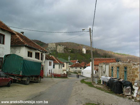
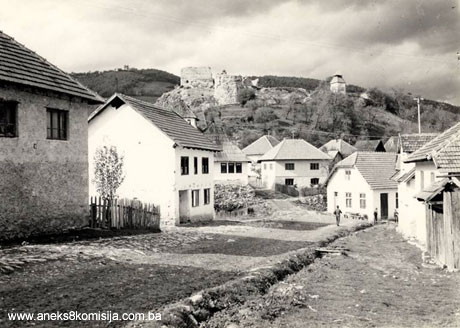
The historic site of the Old Prusac Fort (Biograd, Akhisar) is in Prusac, about 5 km south of Donji Vakuf and about 2 km from the main Donji Vakuf-Bugojno road. It was built on a tongue-shaped rocky eminence rising about 50 m above the Prusačka river, the banks of which are almost vertical at this point. It is thus well protected by the lie of the land on all sides other than the south, where there is a gradual slope. The entire surrounding area could be kept under observation from this point. A civilian settlement took shape below the fort. To the south of the fortifications, on the slope, lies the historic centre of Prusac. It was along this line that piped water was brought to the settlement from Ajvatovica.
The Prusac plain, which was the granary of Uskoplje, extends along the valley below Prusac town. In times of unrest in the 15th to 17th century it was also the place where troops assembled in this insecure frontier region.
Until 1878 and beyond, the main road from central Dalmatia to Bosnia passed through Prusac, with forks to the south, north and east.
In clear weather Donji Vakuf can be seen from the fort.
Historical information
During the course of archaeological excavations conducted in the 1980s on the hilltop, within the citadel walls, prehistoric material from the Eneolithic, Bronze and Iron ages was discovered. There was a hillfort settlement here, which was destroyed by later building works in the mediaeval and Ottoman periods (Marijanović, 2001, 90-114). The assumption is that in antique times there was a road between Prusac and neighbouring settlement, but its location has not yet been discovered (Pašalić, 1960, 41). The archaeological excavations revealed no antique remains in the old fort. Mazalić is of the view that the cobbles in Prusac, the remains of which were still visible in the 1950s on the main road through the settlement outside the main gatehouse to the fort, were of antique origin (Mazalić, 1951, 174).
Prusac was in the mediaeval župa of Uskoplje, which was divided into Upper and Lower Uskoplje. Susid fort was in Upper Uskoplje and Prusac and Vesela Straža in Lower Uskoplje. There are no surviving documentary sources on Prusac in the mediaeval period.
During fighting between the Ottomans and the Hungarians in the second half of the 15th century the border in Uskoplje župa was a shifting line. The Ottomans probably took the fort in 1463, but it did not remain under their control. In the autumn of that year the army of Herceg Vladislav, which operated in Uskoplje župa, helped to liberate Jajce from the Ottomans. It was then, most likely, that Prusac came under the rule of Herceg Vladislav.
The 1468 defter makes no reference to Vesela Straža or Biograd, but does refer to the fort of Susjed and Gračanica market (Šabanović, 1982, 128; Dinić, 1978, Zemlje, 240). The forts are not listed in the 1485 and 1489 inventories either.
Ÿ The earliest reference to the name Prusac is in a letter from the Bosnian sancak governor Skender-paša Mihajloglu (Mihajlović) to the Ragusans, written “In Prusac fort 29 July”. The year is not noted, but Truhelka dates the letter to 1478, or more likely to 1478-80. This date is also cited as the earliest reference to the Prusac fort by Mazalić, Kreševljaković, Vego and Šabanović (Truhelka, 1911, 49-50; Mazalić, 1951, 151; Kreševljaković, 1953, 23; Vego, 1957, 98; Šabanović, 1982, 43).
Ÿ In 1499, Skender-paša concentrated his troops in the Prusac plain to be ready for an attack on Jajce, while a Hungarian garrison was stationed in the fortress above. During the Jajce banate, 1464-1527, the fort passed from Hungarian to Ottoman hands and back several times, and people from Klis sancak often stayed in the fort.
Ÿ Prusac was finally conquered by Skender-paša’s son Mustaj-beg in 1502 (Mazalić, 1951, 151).
Ÿ Under the terms of a treaty between the Ottoman Empire and Hungary dated 20 August 1503, Prusac remained under Ottoman rule.
Ÿ Hungaro-Turkish sources dating from 1503 and 1519 refers to the fort by the name Belgrad = Biograd. Every Turkish-language documentary source refers to it as Akhisar, which is a literal translation of Biograd.
Two nahiyes feature in Uskoplje-Skoplje in early Ottoman documents. First to be founded was the nahiye of Skoplje, in Upper Skoplje, headquartered in Susid. When Prusac was taken, the nahiye of Belgrad (Akhisar) in Lower Skoplje was formed. This nahiya belonged to the Neretva vilayet and kadiluk; the earliest reference to it dates only from 1540. Towards the end of the 16th century Akhisar became the seat of the kadiluk and belonged to the Klis sancak. At that time Akhisar was the strongest fort and also an important cultural centre (Šabanović, 1982, 151, 153, 205, 213).
Since Prusac was on a crossroads, and on the main road leading from the Split region to Bosnia, between 1550 and the construction of the new Donji Vakuf-Bugojno road sometime after 1878 numerous travellers and delegations passed through it.
• In 1550, Catarino Zeno passed through the town, referring to it as “Castel bianco” (Biograd), and in 1531 Kuripešić also travelled through.
From the 16th century on, Bosnian governors and people from Klis sancak often encamped in Prusac, guarding the borders and preparing for incursions into neighbouring Venetian and Austrian territory (Šabanović, notes to the Bosnian translation of Evliya Çelebi’s travelogue, 1979, 131, nn. 39-40). Between the 16th century and the fall of Klis, Prusac was a duchy in the Klis sancak.
• In 1621, Sahroš Ibrahim-paša Memibegović, the appointed governor of Bosnia, surveyed the Prusac fort. There were then 60 houses within the ramparts and 200 outside. He reports that Prusac had a small castle with a bailey. The town had an aga and a kadi, and was often visited by the sancak [bey], being so close.
• In 1626 Anastazije Đorđić travelled through Prusac.
• In about 1647-48, with the start of the Candian war, Venetian troops advanced as far as Prusac.
• At the time when Çelebi first travelled through Bosnia, in 1660, the Bosnian beylerbey was Melek Ahmed Pasha, Çelebi’s patron, whom he constantly refers to as benefactor and strateg. He does so, too, in relation to Prusac, which the beylerbey renovated and repaired at his own expense (Çelebi, 1979, 132). At this time the fort had a dizdar or fort commander and 300 men, and 80 houses in the bailey. During the Candian war Prusac was the strategic defence in the defile through which Venetian troops (uskoks, as Çelebi calls them) could advance deeper into Bosnia. Çelebi records that the varoš (town) had eight mahalas with 800 solidly built houses (there was a large quarry nearby), single or two-storeyed, eight mosques, three tekkes, a hamam and eighty shops.
• In 1692 there occurred the second major incursion into Uskoplje by the Morlachs (Black Vlachs), aided by the Venetians, looting and plundering their way as far as Prusac and Donji Vakuf.
The first dizdar known by name was Hasanaga, who served until 1768. He was succeeded by his son Mustafa-aga, who held the post until the 1780s. The last dizdar was Abdulah-aga Rustempašić. In 1833 the fort had 7 cannon (Kreševljaković, 1952, 154).
The fort was abandoned in 1838. In Omer-paša Latas’s time, in the mid 19th century, Akhisar belonged to the Travnik kajmakamluk (district), but the centre of the mudirluk (county) remained there. When the Austro-Hungarian troops occupied Bosnia, the army stayed for a short while in the fort.
2. Description of the property
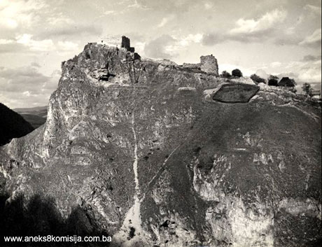
The fort consists of three components: the fortress-citadel or acropolis on the hilltop, the bailey below it, and the Lower fort. These were built one after the other. The old fort covers an area of about 22,000 sq.m.
Fortress-citadel
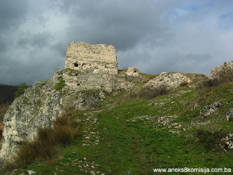
The approximate date, even, when the fortress and bailey were built is unknown, but it was probably in the late mediaeval period. The natural hilltop plateau on which the fortress was built measures 20 x 20 m and lies south-west/north-east. The size and shape of the fortress is perfectly adapted to the rocky terrain and fortification principles. The fortress is quadrilateral in plan with the north side cut off and terminating in a triangle (40o). To judge from its form it is of relatively late date, in the15th century. Exposed as it was to attack from three sides, it is surrounded by thick ramparts. The west wall has not survived, and even when it still stood it was less thick (about 1 m, the standard mediaeval thickness), since there was no danger from this direction. The thickest (2.4 m) and best equipped with loopholes and apertures for cannon is the south-east wall. All that now survives is just one aperture for firearms, similar to that on tower I. The continuation of this wall is the north-east wall, of the same thickness but without loopholes. The entrance to the fortress is near the end of this wall; it is now no more than a breach in the wall about 3 m wide. The stones that were laid to form the threshold can be discerned on the ground, as well as a few cobblestones outside the entrance. Here the wall turns at an angle of about 40o, continuing on as the north-west wall (1.5 m thick). Both walls are about 15 m long.
A quadrilateral tower of irregular shape was built on to the inside of the south end of the south-east wall. The south-east wall is 19 m long, two metres longer than the north-west wall. The walls of the tower have survived to a maximum height of 6-10 metres, depending on whether one looks at them from the inside or the outside. The thickness of the walls varies. The south-east wall is part of the perimeter rampart and is 2.2 m thick, the north-west wall is 2 m thick, and the longer walls are up to a metre thick. In some places they have almost collapsed, and there are also gaps in the walls. At some later date three apertures for cannon were built into the south-east wall, of which the one on the south corner survives, but the other two are filled with rubble. The surviving aperture is 1.45 m high as seen from the inside, and is about 1.70 m deep. The lower part of the tower has clearly become filled in to a height of about 1.5 m, or almost the entire height of the ground floor. Above the ground floor, another two rows of holes are visible on the wall face where the ceiling joists fitted. In some places on the interior smooth plaster of good quality and as hard as cement has survived on the walls, which means that the entire interior of the tower was plastered in this way. Mazalić found a heap of ruins outside the tower to the right and left of the entrance, suggesting that there was once a building of some kind there (Mazalić, 1951, 173).
Diagonally from the tower, at the end of the north-west wall, is a smaller guard tower, with a well beside it. Mazalić found there a circular well with a diametre of 1.5 m and a stone parapet (1951, 173). When the site was visited in November 2003 the outside of the upper part of the well consisted of a newly built rectangular masonry parapet. The interior was not plastered.
The guardhouse stood on the highest point of the terrain. It was of irregular shape. The entrance wall has not survived. The longer walls are 0.8 to 1.0 m thick by the entrance wall, increasing to 1.7 m thick at the other end. As a result, the interior is 2 m wide at the entrance side and 0.2 m narrower on the opposite site. It is 3.3 m long, but seems to have formerly been a metre longer (Mazalić, 1951, 173). The wall facing the entrance is about 2 m thick, and has a larger aperture for cannon. It is of the same type as the southern aperture in tower I. It was subsequently partly walled up, and now, as a result of the ground level of the guardhouse becoming filled in, only the upper part can be seen. The western perimeter rampart led from the guardhouse to tower I, but is no longer visible on the ground.
To the west of tower I, on the rocky terrain above the river, Mazalić identified a few remains of a wall (a lookout post) No evidence of the secret passageway to be used in case of danger, which local tradition claims, has been found.
Bailey below the fortress
The fortress was surrounded on outside, where it was easily approachable – from the western to the end of the south-eastern wall – by a moat 3-4 m deep and up to 6 m wide, with a bridge over it. The moat is now partly filled in, and the access to the fortress is covered with earth. Parallel to tower I, the outer, southern part of the moat, which is hollowed into the rocky ground at this point, is surrounded by a thin wall about 1 m thick, built later,in which two apertures for firearms have survived and are visible from the exterior. They have frames consisting of four monoliths, with the opening between measuring 30 x 40 cm. They are now buried on the inside. This forms part of the perimeter wall of the bailey below the fortress, which takes a right-angled turn and continues towards tower II, a length of about 40 m. This wall is about 1 m thick below tower I, thickening to 2 m towards tower I. The main entrance to the bailey stands about 1.5 m from tower II. The location of the entrance is well defended from both towers. The entrance is now merely a gap in the wall, much of which is crumbling. All that survives is the core and a few remains of the exterior revetment by tower II. Here too are the remains of a loophole, now buried on the inside.
Tower II is octagonal in shape, and forms part of the defensive structure of the bailey below the fortress. The present height of the tower is about 7 m on the outside, while inside the ground has been filled in and levelled, to at least half the height of the ground floor. Holes for the beams that separated the ground from the upper floor are visible on the inside wall. There are three loopholes on the ground floor, of the same type as in the wall linking tower I and tower II. The entrance to the tower was from the north-east, but there is no surviving trace of the door jambs, merely an opening about 2 m wide. The exterior diameter of the tower is about 12 m and the interior about 8 m. The walls are up to 2 m thick. The revetment has fallen from the exterior walls of the tower in many places, but much of it has survived in the interior.
Mazalić found the remains, or the rubble, of a building in the bailey between the entrance and tower II, measuring 12 x 6-8 m (Mazalić, 1951, 175). Local tradition claims that these are the ruins of the Bajazidija mosque. A surviving tarih or chronogram of the renovation of the mosque in 1601 records that a mosque (the Bajazidija) was built in 1488 by Skender-paša in the Prusac fort and dedicated to the Sultan of the day, Beyazit II (1481-1512). The mosque was extensively repaired by Kjafija in 1601, as to which the inscription reads, in translation: “This mosque was built to the order of Sultan Beyazit by the late Iskender-paša in 893 [1488] and renovated by kadija Hasan of Akhisar in 1010 [1601/2] “. This significant inscription, artistically incised on stone, is preserved in the turbe of the well known scholar Hasan Kjafija in Prusac (Spaho, 1983, 42-43). In the second half of the 17th century, some sixty years after the renovation, Çelebi wrote (in 1660) that there was no imperial osque in the fort (Çelebi, 1979, 132). During archaeological works conducted as part of the project entitled “Uskoplje Župa in the mediaeval and early Turkish periods (to the 17th century)”, part of the foundation walls of a building lying west-east were uncovered under the rubble of the building that tradition holds are the ruins of the Bayazidija mosque. The building measured 10.9 x 5.9 m, with walls 0.6 m thick, of cut stone, laid without great care in courses and bonded with a little lime mortar. At the western end of the south wall of the building that had been discovered, it was ascertained that a later building lying north-east/south-west had been built on the old wall. The walls of this later building were of good, regularly cut stone blocks. The different wall structures and orientation of the two buildings, and the local tradition that there was a mediaeval church here on which a mosque was later built in 1488, led the archaeologists to assume that the Carevica or Bajazidija mosque was built on the foundations of the church (Spaho, 1983, 33) (1).
The bailey by the fortress was surrounded by a wall to the east and north-east, about 1 m thick and 2-3 m high, with three quadrangular towers (marked on the plan as bastions I, II and III). All that remains of this wall is some minor remains between tower I and bastion I, and some of the walls of “bastions” II and III. The bailey covers an area of about 3,000 sq.m., with a length of 50 m and a width of 60 m.
Chronologically, the fortress was the first to be built, followed by the bailey below it with tower II and the three bastions. Both complexes are built of well-dressed local stone, limestone and tufa, well bonded with thin layers and joints of good quality mortar. The sand used in the mortar had been screened, which is the basic difference between mediaeval building techniques and later Ottoman period building, when unscreened river sand which included larger-grade gravel was used.
There was another moat below the east wall of the bailey, running along its entire length. The moat was 6-10 m wide and about 3 m deep. It began to erode in the 19th century. A clock tower was built in it, probably in the 18th century.
Clock Tower
Çelebi makes no reference to this tower in 1660, so it must have been built after his time, probably in the 18th century. The fort was no longer of great strategic importance, and the clock tower was built in the moat encircling the bailey below the fortress. The tower is square in section, with the sides measuring 3.9 m, and with a height of about 10 m. The tower was perhaps built by one of Prusac’s dizdars, one of whom is known to have endowed an estate near Prusac the revenues of which were to be used to pay an official to look after the clock. This land still belongs to the tower to this day. The bell dates from 1633. Local people say that the clock mechanism was made by a clockmaker from Gornji Vakuf. The clock has no face (Kreševljaković, 1957, 25-26; Mazalić, 1951, 178).
Lower Fort
Yet another bailey took shape on the eastern slope below the fortress – the Lower Fort, occupying an area of approx. 90 x 180 m and containing a settlement within ramparts. The outer perimeter walls of the entire complex of the old Prusac fort ran from the moat below tower I, to the south-east of bastion IV. The lower part of the perimeter ramparts ran from here south-west to tower IV to the north, at the foot of the slope on which the fort lay. The north wall of the bailey ran from tower IV in an irregular line to bastion III in the bailey. There were projecting towers (bastion III, towers III and IV) in the east bailey wall at the southern end, in the centre and at the northern end, each with three apertures for firearms, similar to those on the southern perimeter wall of the fortress, the south wall of the bailey and tower II. There was a moat about 10 m wide outside this wall, now completely filled in.
The main gatehouse was in the south-west part of the lower fort. The fort was approached by a cobbled road; the main Prusac road was also cobbled. The access road was 3 m wide and is now asphalted. There was a crossroads by the gatehouse, which was still being called “londža” (“meeting place”) by the older locals in the mid 20th century (Mazalić, 1951, 172). Prior to 1878 the main gatehouse to the fort with its oak doorframe and iron plates still stood. The Austrians removed it all and used it for other purposes. Around 1950 part of the doorjamb of the gatehouse still lay by the town mosque (Mazalić, 1951, 167), but it is now no longer there.
The lower fort and the south-western perimeter wall were probably built in the late 15th century. Later repairs to parts of the wall are to be seen. Repairs to the entire fort are known to have been carried out during the time of the Bosnian beylerbey Melek Ahmed-pasha in the second half of the 17th century (Mazalić 1951, 167). Prusac was an important site in the early Ottoman period, as it was again later in the 17th century. Although it always remained a duchy, from the 16th century on people from the Klis sancak and Bosnian governors encamped there from time to time, guarding the frontier and launching incursions into Venetian and Austrian territory.
There was a moat outside the gates to the fort, cut into the rocky soil, with a drawbridge. Çelebi found 80 soldiers’ houses in the fortress, and particularly notes that there was no imperial mosque, armoury, granary or anything else there (Çelebi, 1979, 132).
3. Legal status to date
Pursuant to the law, and by Ruling of the Institute for the Protection of Cultural Monuments of NR BiH No. 02-747-3 of 18 April 1962 in Sarajevo, the site of the Old Fort in Prusac was placed under state protection.
The historic site of the Old Fort in Prusac is on the Provisional List of National Monuments as the Prusac Fortress, under serial no. 209, and the ruins of the Beyazit mosque under serial no. 206.
The Regional Plan for BiH to 2000 lists the building as a Category III monument.
4. Research and conservation and restoration works
1958 – repairs to the Clock Tower in Prusac.
1982-1983 – archaeological excavations conducted as part of the project entitled “ Uskoplje Župa in the mediaeval and early Turkish periods”, led by the Republic Institute for the Protection of Cultural Monuments and the Natural Heritage of BiH. The results were set out in a report to the Self-Managing Cultural Association of RbiH, but the only part that was published was the section relating to the prehistoric strata in the Prusac fort (Marijanović, 2001).
The archaeological material excavated during these works in 1983 in the Prusac fortress consisted of metal and pottery items and part of a capital, probably from the mosque. The metal items are in the National Museum of BiH in the mediaeval collection, and all the rest, which remained in the Republic Institute for the Protection of the Cultural, Historical and Natural Heritage of BiH in Sarajevo, disappeared during the 1992-1995 war.
5. Current condition of the property
An on-site inspection conducted on 27 November 2003 ascertained the following:
About sixty years ago Mazalić visited the fort and described it in detail. By comparison with the plan of the fort and the ruined sections that he drew, the present situation is markedly worse (on the plan the ruinous sections are marked by lines by the walls). Parts of the walls are overgrown with vegetation. The moats were used in part in the 1992-1995 war, and trenches were dug in the bailey.
Fortress
The revetment has fallen from the surviving sections of the perimeter ramparts. The entrances to the building are merely gaps, with no structural elements remaining. The interior revetment of the walls of tower I and the guardhouse has fallen away in part. In some areas inside tower I only the lower courses of the revetment survives. The revetment of the outside walls of both buildings has partly fallen away, mainly at the corners. The well has since been repaired, with parapet walls and a top slab.
Bailey
The wall between tower II and bastion I has suffered badly. In parts there are simply ruins, with no surviving revetment, on parts of the retaining wall. The exterior revetment of tower II has also suffered badly, as has that of the perimeter walls extending from the tower in both directions. The entrances to the bailey and tower II are mere gaps in the wall.
During the 1992-1995 war a trench was dug in the bailey at right angles to the mediaeval moat, ending at the southern end of the moat with an opening that was closed off by a kind of “door” made of planks.
Lower Fort
The gatehouse has been completely destroyed. The perimeter wall from the south-west corner to the place where the gatehouse formerly stood is fairly ruinous and overgrown. All that remains of bastion IV is the corner that projected furthest outwards. The height of the perimeter wall varies, up to two metres, but the wall has almost completely disappeared in some places. The section of the perimeter rampart from the gatehouse to the northern corner and tower IV has partly survived to a height of about 1.5 m over a length of several metres. In some places it is overgrown with vegetation.
Building of houses and the development of mahalas began long since at the base of the Lower Fort and in the south-western part of the bailey (from the access road to the fortress), which is now packed with houses and courtyards. The moat that formerly encircled the ramparts of the Lower Fort has long since been filled in and a street now runs there.
The upper section of the south-western perimeter rampart is completely ruinous, with only the retaining walls on the slopes surviving. A little of the wall remains at the angle from which the Lower Bailey and the inhabited area begins. From there to bastion IV the above-ground parts of this wall, which is thinner than the others, have survived in part.
III – CONCLUSION
Applying the Criteria for the adoption of a decision on proclaiming an item of property a national monument (Official Gazette of BiH nos. 33/02 and 15/03), the Commission has enacted the Decision cited above.
The Decision was based on the following criteria:
A. Time frame
B. Historical value
C. Artistic and aesthetic value
C.iv. composition
D. Clarity
D.i. evidence of historical changes
F. Townscape/landscape value
F.ii. meaning in the townscape
F.iii. the building or group of buildings is part of a group or site
G. Authenticity
G.i. form and design
G.v. location and setting
H. Rarity and representativity
H. i. Unique or rare example of a certain type or style
The following documents form an integral part of this Decision:
- Copy of cadastral plan
- Photodocumentation;
- Drawings
Bibliography:
During the procedure to designate the monument as a national monument of Bosnia and Herzegovina the following works were consulted:
Çelebi, Evliya, Putopis (Bosnian translation of his Travelogue) Cultural Heritage Editions, Veselin Masleša, Sarajevo,1979.
Dinić, Mihajlo, Zemlje hercega sv. Save. (Lands of Herceg St. Sava) in: Srpske zemlje u srednjem veku (Serbian lands in the mediaeval period). Belgrade, 1978, 178-269.
Kreševljaković, Hamdija, Prilozi povijesti bosanskih gradova pod turskom upravom. (Contributions to the history of Bosnian towns under Turkish rule) Conbtributions for oriental philology and the history of the Yugoslav peopls under Turkish II/1951, Sarajevo, 1952., 119-184
Kreševljaković, Hamdija, Sahat-kule u Bosni i Hercegovini. (Clock towers in BiH) Naše starina IV, Sarajevo, 1957, 17-32.
Kreševljaković, Hamdija Stari bosanski gradovi, (Old Bosnian forts) Naše starine I, Sarajevo, 1953. 7-45.
Marijanović, Brunislav, Prusac (Biograd) - prapovijesno višeslojno nalazište.(Prusac [Biograd] – a prehistoric multistrata site) Journal of the National Museum in Sarajevo (Archaeology), new series, svVoleska 48/49, Sarajevo, 2001, 92-99.
Mazalić, Đoko, Biograd-Prusac, stari bosanski grad. (Biograd-Prusac, old Bosnian fort) Journal of the National Museum in Sarajevo, new series no. VI, Sarajevo, 1951, 147-189.
Pašalić, Esad, Antička naselja i komunikacije u Bosni i Hercegovini. (Antique era settlements and communications in BiH) Special publication by the National Museum, Sarajevo, 1960
Šabanović, Hazim, Bosanski pašaluk, postanak i upravna podjela (Bosnian pashaluk, genesis and administrative division) Svjetlost, Sarajevo, 1982.
Spaho, Fehim, “Župa Uskoplje u srednjem vijeku i ranom turskom periodu (do 17.st) sa posebnim osvrtom na utvrđene gradove Vesela Straža, Susjedgrad i Prusac.” (Uskoplje Župa in the mediaeval and early Turkish periods – to 17th C) Institute for the Protection of Cultural Monuments and Natural Sites of BiH Sarajevo. Research project SIZ studies BIH. Sarajevo, 1983, 1- 366.
Truhelka, Ćiro, Naši gradovi, opis najljepših sredovječnih gradova Bosne i Hercegovine, (Our forts, description of the finest mediaeval forts of BiH) Sarajevo, 1904. 64-69.
Truhelka, Ćiro, Tursko-slovijenski spomenici dubrovačke arhive. (Turko-Slav monuments in the Dubrovnik archives) Journal of the National Museum in Sarajevo XXIII, Sarajevo, 1911, 1-162.
Vego, Marko, Naselja srednjevjekovne bosanske države (Settlements of the mediaeval Bosnian state) Sarajevo, 1957.
|