Published
in the “Official Gazette of BiH”, no. 3/10.
Pursuant
to Article V para. 4 Annex 8 of the General Framework Agreement for Peace in Bosnia and Herzegovina
and Article 39 para. 1 of the Rules of Procedure of the Commission to Preserve
National Monuments, at a session held from 7 to 11 October 2003 the Commission
adopted a
D E C I S
I O N
I
The
natural and architectural ensemble of the river Bregava with flour mills,
fulling mills and bridges, Stolac Municipality, is
hereby designated as a National Monument of Bosnia and Herzegovina
(hereinafter: the National Monument).
The
National Monument consists of all the bridges, flour mills, fulling/rolling
mills and troughs on the river Bregava between Poplašić mahala to Ošanići
mahala (including the properties in these two mahalas), the Pjene, Provalije
and Veliki Bent waterfalls, the riparian area of the river Bregava, and both
banks up to the inner limit of the road parallel with the river from Poplašić
mahala to the Podgrad mosque.
The
National Monument is located on a site designated as cadastral plot no. 1308/1
(old survey), title deed no. 198, Land Register entry no. Iskaz I; c.p. no.
IV/29 (old survey), title deed no. 198, Land Register entry no. Iskaz I; c.p.
no. VII/34 (old survey, title deed no. 883, Land Register entry no. 1041; c.p.
no. VII/33 (old survey), title deed no. 771, Land Register entry no. 151,
cadastral municipality Stolac, and c.p. no. 488/1, title deed no. 308, Land
Register entry no. 358, cadastral municipality Ošanići, Stolac Municipality,
Federation of Bosnia and Herzegovina, Bosnia and Herzegovina.
The
provisions relating to protection and rehabilitation measures set forth by the
Law on the Implementation of the Decisions of the Commission to Preserve
National Monuments, established pursuant to Annex 8 of the General Framework
Agreement for Peace in Bosnia and Herzegovina (Official Gazette of the
Federation of BiH nos. 2/02 and 27/02) shall apply to the National Monument.
II
The
Government of the Federation of Bosnia and Herzegovina (hereinafter: the
Government of the Federation) shall be responsible for providing the legal,
scientific, technical, administrative and financial measures necessary for the
protection, conservation, restoration, presentation and rehabilitation of the
National Monument.
The
Government of the Federation shall be responsible for providing the resources
for drawing up and implementing the necessary executive regional planning
documentation for the National Monument.
The
Commission to Preserve National Monuments of Bosnia and Herzegovina
(hereinafter: the Commission) shall determine the technical requirements and
secure the funds for preparing and setting up signboards with basic details of
the monument and the Decision to proclaim the property a National Monument.
III
To ensure
the on-going protection of the National Monument, the following protection
measures are hereby stipulated:
Protection
Level I applies to the area defined in Clause 1 para. 3 of this Decision.
-
all works are prohibited
other than conservation and restoration works, the reconstruction of the
original buildings or parts thereof, works designed to ensure the sustainable
use of the properties, routine maintenance works on the properties forming the
natural and architectural ensemble, including those designed to display the
monument, subject to the approval of the Federal ministry responsible for
regional planning (hereinafter: the relevant ministry) and under the expert
supervision of the heritage protection authority of the Federation of Bosnia and Herzegovina
(hereinafter: the heritage protection authority);
-
all works that could be
detrimental to the National Monument are prohibited, such as the construction
of new buildings on the site of the National Monument, or the extension,
addition of storeys or other such works on existing properties;
-
the felling of low-growing
vegetation, shrubs and trees is prohibited except where necessary to maintain
forest health and vitality or when the plants pose a threat to the stability
and structure of the buildings;
-
the erection of temporary
facilities or permanent structures not designed solely for the protection and
presentation of the National Monument is prohibited;
-
during reconstruction,
restoration, conservation and routine maintenance of the properties forming the
natural and architectural ensemble, their original appearance shall be
retained, as shall the original type of roof structure, and original materials
shall be used and original building methods and techniques applied;
-
all methods and degrees of
intervention must be readable;
-
it is recommended that the
original use of the properties be retained. No change of use shall be such as
to alter the appearance of the buildings or their immediate surroundings
(alterations to their horizontal and vertical dimensions, façades and interior,
roof panes and interior layout are prohibited, as is the addition of pent roofs
etc.). No new use may be such as to impair the value of the townscape/landscape
or the value of the properties as monuments;
-
a project for the
landscaping of the banks of the river Bregava shall be drawn up on the basis of
a prior evaluation;
-
a detailed plan for the
protection of the National Monument shall be drawn up, which shall pertain to
the ensemble as a whole and to the individual properties within the protected
area defined in Clause 1 of this Decision;
-
a detailed conservation
plan shall be drawn up, to include protection measures for the natural and
built heritage;
-
a programme for the detailed
evaluation of the flora and fauna of the river Bregava and its banks shall be
drawn up every five years;
-
the evaluation of the
flora and fauna of the river Bregava and its banks shall be used every five
years as the basis for designing and implementing a project for the sustainable
protection of endemic and endangered species, with particular reference to Salmothymus
obtusirostris oxyrhynchus, Chondrostoma knerii, Barbitistes yersini, Poecilimon
elegans, Platycleis orina and Ephippiger discoidalis;
-
fishing is prohibited in
the Bregava from Poplašića mahala to the Podgrad mosque;
-
in the fulling mills still
in use, biodegradable detergents only shall be used;
-
washing cars on the banks
of or in the river Bregava, discharging waste water into the river and dumping
waste are prohibited;
-
the construction of dams,
channels or other infrastructure for the generation of hydro power on the river
Bregava is prohibited;
-
the extraction of tufa
deposits from the bed of the river Bregava is prohibited;
-
alterations to the course
of the river Bregava are prohibited, as is laying concrete on the river bed;
-
the removal of vegetation
and the installation of artificial beaches are prohibited;
-
potential polluters of the
river Bregava and its banks shall be identified, remedial works shall be
carried out, and a plan covering waste management, waste water management,
environmental management and the management of natural resources shall be drawn
up.
The
following urgent protection measures are hereby stipulated to protect
the National Monument:
-
conduct a preliminary
survey of the current situation, to determine the condition of and extent of
damage to the properties forming the natural and architectural ensemble;
-
conduct emergency
protection works on the properties most at risk (reconstruction and restoration
of roof structures, replacement of damaged areas of roof cladding, injecting
structural cracks etc.);
-
conduct a detailed survey
of the current state of the natural and architectural ensemble to identify:
-
the current condition of
the properties as regards the extent of preservation of their original
structure and appearance,
-
the exact extent of the
damage to each property,
-
the causes of
deterioration and degradation of the properties and the values of the natural
and architectural ensemble;
-
draw up a conservation,
restoration and revitalization project based on the survey of the current
situation;
-
conservation and
restoration of the properties in line with the conservation project;
-
draw up a maintenance
programme and plan for the properties forming the natural and architectural
ensemble, defining the organizations to be responsible for implementing the
said programme;
-
draw up a programme for
the revitalization of the National Monument.
A buffer
zone is hereby prescribed to protect the values of the natural and
architectural ensemble. The buffer zone consists of a strip 50 metres wide on
both sides of the river Bregava beyond the boundaries of the National Monument.
The following protection measures shall apply in this zone:
-
the construction of new
buildings and any extension, enlargement or alteration of the properties in the
buffer zone that could have the effect of endangering the National Monument or
impairing its appearance and values are prohibited;
-
interventions on the
properties in the buffer zone that have been carried out without permission
shall be removed to restore the buildings to their original condition;
-
the erection of
advertising hoardings, notice boards and signs impairing the view and obscuring
the natural and architectural ensemble is prohibited;
-
the construction of
additional infrastructure facilities, power transmission lines, electricity
transformer stations or substations etc. is prohibited except with the approval
of the relevant ministry and subject to the opinion of the heritage protection
authority.
IV
All
executive and area development planning acts not in accordance with the
provisions of this Decision are hereby revoked.
V
Everyone,
and in particular the competent authorities of the Federation of Bosnia and
Herzegovina, the Canton, and urban and municipal authorities, shall refrain
from any action that might damage the National Monument or jeopardize the
preservation thereof.
VI
The
Government of the Federation, the relevant ministry, the heritage protection
authority, and the Municipal Authorities in charge of urban planning and land
registry affairs, shall be notified of this Decision in order to carry out the
measures stipulated in Articles II to V of this Decision, and the Authorized
Municipal Court shall be notified for the purposes of registration in the Land
Register.
VII
The
elucidation and accompanying documentation form an integral part of this
Decision, which may be viewed by interested parties on the premises or by
accessing the website of the Commission (http://www.aneks8komisija.com.ba)
VIII
Pursuant
to Art. V para 4 Annex 8 of the General Framework Agreement for Peace in Bosnia and Herzegovina,
decisions of the Commission are final.
IX
On the
date of adoption of this Decision, the National Monument shall be deleted from
the Provisional List of National Monuments of Bosnia and Herzegovina (Official
Gazette of BiH no. 33/02, Official Gazette of Republika Srpska no. 79/02,
Official Gazette of the Federation of BiH no. 59/02, and Official Gazette of
Brčko District BiH no. 4/03), where it featured under serial nos. 590 and 591.
X
This
Decision shall enter into force on the day following its publication in the
Official Gazette of BiH and the Official Gazette of the Federation of BiH.
This
Decision has been adopted by the following members of the Commission: Zeynep
Ahunbay, Amra Hadžimuhamedović, Dubravko Lovrenović, Ljiljana Ševo and Tina
Wik.
No: 02-6-993/03-1
8 October 2003
Sarajevo
Chair of
the Commission
Amra
Hadžimuhamedović
E l u c i
d a t i o n
I – INTRODUCTION
Pursuant
to Article 2, paragraph 1 of the Law on the Implementation of the Decisions of
the Commission to Preserve National Monuments, established pursuant to Annex 8
of the General Framework Agreement for Peace in Bosnia and Herzegovina, a
“National Monument” is an item of public property proclaimed by the Commission
to Preserve National Monuments to be a National Monument pursuant to Articles V
and VI of Annex 8 of the General Framework Agreement for Peace in Bosnia and
Herzegovina (hereinafter: Annex 8) and property entered on the Provisional List
of National Monuments of Bosnia and Herzegovina (Official Gazette of BiH no.
33/02) until the Commission reaches a final decision on its status, as to which
there is no time limit and regardless of whether a petition for the property in
question has been submitted or not.
The
Commission to Preserve National Monuments issued a Decision to add the mills
and the bridge on the Ada to the Provisional
List of National Monuments of Bosnia and Herzegovina, numbered as 590
and 591.
Pursuant
to the provisions of the law, the Commission proceeded to carry out the
procedure for reaching a final decision to designate the Property as a National
Monument, pursuant to Article V of Annex 8 and Article 35 of the Rules of
Procedure of the Commission to Preserve National Monuments.
Statement of Significance
The
natural and architectural ensemble of the river Bregava with its bridges, flour
mills and fulling mills is a monument of outstanding value and testimony to the
skills of local builders and the vernacular architecture they produced.
It also
attests to the way of life of the people of Stolac over the three hundred years
during which the ensemble was constantly developing, and to their daily needs
and way of doing business.
The
Bregava is a karst river that rises in Do, below Mt Hrgud, and joins the river
Neretva at Klepci near Čapljina. For most of its length it flows through
Stolac, forming the mainstay of its historical development. The river is clear,
fast-flowing for the most part, and twice divides into branches which then
rejoin into one. It has two sizeable natural falls – above the Begovina, known
as Pjene, and above Propa, known as Provalije. In the 18th century a number of
bents or barriers were built in the river, forming artificial waterfalls; the
best known of these is Veliki bent by the Šarić summer residence. Fifteen
bridges have been built in Stolac since mediaeval times, ten of which are
historic buildings.
The river
has been used as a natural resource for the development of the economy and
transport. The many buildings along the river, the work of local builders,
attest to the interconnection, social development and interaction between the
people and their natural surroundings.
Mills,
with millstones for grinding grain, and fulling mills with troughs and vats for
fulling and dyeing cloth, have been built on the Bregava since the 15th
century. In the 18th century mills were part of the endowments of some of
Stolac’s best known benefactors – among the families who owned flour mills, fulling
mills and troughs were the Mehmedbašić, Behmen, Rizvanbegović, Šator, Leto,
Matić, Mahmutćehajić, Lalić, Buzaljko, Elezović, Turković, Haračić, Sidran and
Soldin families. Flour mills are long, narrow buildings built over the river
like bridges, with several arches; their walls are of rubble stone, and their
gabled roofs are clad with stone slabs. Each flour mill would have as many
millstones as it had arches. In some cases one flour mill would be worked by
several millers. Fulling mills are simple stone structures with gabled roofs,
sometimes two-storied, with vats and troughs for fulling, dyeing and washing
cloth. Flour mills and fulling mills were usually built side by side where the
current was favourable.
Until
World War II people’s lives in Stolac depended largely on the Bregava, on
account of the flour mills and fulling mills from which they earned their
living. Twelve mill complexes, with flour mills, fulling mills and vats, still
survive in Stolac, some intact, others in ruins.
II – PROCEDURE PRIOR TO DECISION
In the
procedure preceding the adoption of a final decision to proclaim the property a
national monument, the following documentation was inspected:
-
Documentation on the
location and current owner and user of the property (title deed and copy of
cadastral plan).
-
Data on the current
condition and use of the property, including a description and photographs,
data of war damage, data on restoration or other works on the property, etc.
-
Historical, architectural
and other documentary material on the property, as set out in the bibliography
forming part of this Decision.
The
findings based on the review of the above documentation and the condition of
the site are as follows:
1. Details of the property
Location
The
natural and architectural ensemble of the river Bregava with its flour mills,
fulling mills and bridges extends through the entire town of Stolac, consisting of the river itself and
all the buildings and structures built on it.
The
National Monument is located on a site designated as cadastral plot no. 1308/1
(old survey), title deed no. 198, Land Register entry no. Iskaz I; c.p. no.
IV/29 (old survey), title deed no. 198, Land Register entry no. Iskaz I; c.p.
no. VII/34 (old survey, title deed no. 883, Land Register entry no. 1041; c.p.
no. VII/33 (old survey), title deed no. 771, Land Register entryno. 151,
cadastral municipality Stolac, and c.p. no. 488/1, title deed no. 308, Land
Register entry no. 358, cadastral municipality Ošanići, Stolac Municipality,
Federation of Bosnia and Herzegovina, Bosnia and Herzegovina.
Historical information
“Evidence
is to be found along the river Bregava, which rises above Stolac and flows into
the Neretva near Čapljina, of human habitation from every age, from the
Neolithic to the Illyrians and Romans, mediaeval times, the Turks and modern
times. Stolac itself, a little town which took shape along the upper reaches of
the river, is a very ancient settlement.”(1)
The
Stolac čaršija as it now is began to develop in the early 16th century along
the river Bregava, which forms its urban backbone. The nucleus of the čaršija,
and its oldest point, from which it began to develop, is the area around the
Čaršija mosque. “The Mala [small] čaršija took shape by the Podgrad mosque, and
the Ćuprija [bridge] čaršija developed around the hammam and the Ćuprija
mosque. Rows of commercial and public buildings linked the Mala and Ćuprija
čaršijas with the Carska [Imperial] čaršija, thereby constituting the Stolac
Čaršija.”(2)
“The
mention of Stolac conjures up, in the minds of mosque of those who know it, the
entirety and diversity of its cultural heritage. However, the first visual
impression felt by a stranger to Stolac is the abundance of water in this oasis
in the karst.”(3)
The river
Bregava is the lifeline of the town of Stolac
and the mainstay of its daily life. Until World War II the livelihood of the
people of Stolac was largely dependent on the Bregava, along and over which
were located the facilities that provided them with an income. After World War
II the economy of Stolac underwent considerable changes, but the river remained
the focus of the daily lives of the people of Stolac, the place where they went
for walks, bathed in summer, gathered on its many bridges, or relaxed on the
terraces of the cafés along the river.
The
age-old interdependence of people and river is reflected in the riverscape
itself – it is impossible to imagine the watercourse and its banks without the
many bridges spanning the river, the flour mills and fulling mills as the image
of the livelihoods assured by the river, and the falls that add vitality to and
enhance the beauty of the natural course of the river.
The
cultural landscape of the river Bregava is a daily reminder of the past of
Stolac, a town where people came from various surrounding areas to grind their
grain and full their cloth. The river and all the small-scale, stone-built
merchant properties built on and over it are directly associated with the
living tradition of its residents. It is a cultural landscape that will always
reflect the culture and way of life that it shaped over such a long period.
Even now,
the cultural landscape of the river Bregava is a vivid memory for many people –
not only the people of Stolac itself, but also those whose forebears used to
come here with packhorses laden with grain and cloth. Stories, legends and
songs about the river Bregava and its flour mills, fulling mills and bridges
are told and retold to this day.
The river
Bregava and the small-scale, markedly vernacular buildings on and over it are
an essential part of the life of every native and resident of Stolac.
Bridges,
flour mills and fulling mills on the river Bregava
“Since
the town took shape along both banks of the Bregava, which are full of both
natural and artificial inlets, it was inevitable that there would have been
bridges here even in ancient times. Curiously, Evlija [Çelebi] does not mention
them, though he scrupulously enumerates other buildings. Later, too, neither
archival records nor travel chroniclers, as though by tacit agreement, make no
reference to any bridge-building in Stolac, though there can be no doubt that
as long ago as Roman times, and above all in mediaeval times, there must have
been at least one solidly-built bridge over the river. The place known as Mostine
[from most = bridge] is probably associated with the oldest crossing
of the Bregava, and last [19th] century Truhelka found vestiges of it – the
masonry foundations of three of the hewn stone piers of a bridge. The bridge
was 3 metres wide, the piers were 4 m apart, and the piers themselves were 0.96
m wide.
Stolac
now has three substantial stone bridges and four smaller ones, all in use and
all in relatively good condition. Though differing in size, design, age,
details, etc., they all have one thing in common: all are the creation of local
masons, without even a hint of the presence of a trained architect from the
centre. Anyone passing through Stolac with a degree of interest cannot but
sense the direct link between these bridges and primitive, purely utilitarian
structures without the least pretension to style such as the mills on the same
river. These mills, of which there were once many in Stolac and of which a
certain number still survive, display a strict functionality of form, the
limitations of the local builder's attachment to stone and round arches as
their most logical structural form. As many as ten identical arched openings
form a long, rhythmical succession over the mill-races, supporting the heavy
millstones and fulling stocks. A builder who used his skills, his primitive
technology and the materials to hand to erect buildings spanning the river from
bank to bank would clearly have no problem applying the same structural
principles to building a bridge. He used the same materials, the same
structural system, the same building methods. True, the span of the openings
became larger on the bridges than in the mills. But one should not imagine that
he made arches of lesser span under the mills because he was afraid to make
them wider; rather, it was because the diameter of the millstone, the primary
machinery, dictated the span of the mill-race.”(4)
The
bridges, and even more so the flour mills and fulling-mills, small structures
built by local masons with but one intention, to ease the lives of the people
of Stolac, remained the most important merchant properties in the town until
the end of World War II. The basis of the economy of Stolac was milling from
the 16th to the mid 20th century, supplemented in the 18th century by
leatherworking.
Identified
over the years by the name of their individual owners, by which they are still
recognizable to this day, the mills are all of the same type, with only minor
differences in the system of building.
They date
from a single period and, as “imperfect” buildings in the organism of the
Čaršija, are the reflection of its perfect structure.
The
earliest known vakufnama [deed of pious endowment] providing details of
a mill in a maintenance vakuf dates from 1815, which means that there were
certainly mills in existence in the early 19th century. However, given that
Stolac was settled and urbanized as far back as the 16th century, it is very
likely that some of the mills are of still earlier date.(5)
According
to Azra Gadžo Kasumović, who bases her claims on the writing of Fehim Dž.
Spaho, there was already one working mill on the Vidoštica/Bregava in mediaeval
times.(6)
Muhamed
Elezović writes in his book that the mills were mentioned by “Evlija Çelebi in
his travelogue in 1664. He says that there are ten mills in Do on the Bregava,
powered by water.”(7)
As Ale
Poljarević notes, one Memibegović recorded 180 mill wheels in the town in the
18th century, which would mean that Stolac had about 22 mills each with eight
or so mill wheels. Milling expanded significantly after World War I, under the
Kingdom of Serbs, Croats and Slovenes(8), as evidenced by details of leases and concessions of mills
dating from that period and up to World War II to be found in the Archive of
Herzegovina.
As
Muhamed Elezović observes, the flour mills in Stolac attracted the rural
population from as far as 40 km away in the direction of Ljubinje and 40 km in
the Bileća direction. During the Kingdom
of Yugoslavia, hundreds
of packhorses laden with grain to be ground came to Stolac every day. This led to
the development of an ancillary branch of the economy: cafés were opened
alongside the mills. Coffee-houses that were popular with the millers were the
Evropa Hotel at Propa, Islam Jaganjac's coffee-house and the café in the
Cultural Centre. Shops also opened alongside the mills(9).
“There
were eight flour mills between the Inat ćuprija and Provaljije. The brothers
Adem and Meho Haračić operated the mill by the Cultural Centre.... My father,
Meho Elezović, and my brother Ibrahim (Šaban) Elezović worked at Pogled....
Above this was the mill worked by Ibro Gerin and Meho Tucaković, alongside
which was Salko Leto's mill; right by Provalija was the mill of Osmo Turković
(Kolumbo).... These mills were to the right of the river Bregava. To the left,
by Provalije, were the mills of Sulo Buzaljko and his son Bajro, with that of
Huso Buzaljko and Džafer Sidran a little further down. There were two mills in
Begovina, both owned by beys, one to the right and the other to the left of the
Bregava. The first was operated by Nusret Rizvanbegović, and the second by
Murat Haračić, known as Brale. There were two mills in Podgrad, one by the Ali
pasha mosque, in Novak, the Ružića mill, where the millwheel was set vertically
in the river. The other was beside the Muftićevina... In the lower Bregava
valley, in Vidovo Polje, Ćamil Dizdar's mill (the Ošanići mill) is still
standing. There were mills at the source of the Bregava in Do(10), some of which are still in good
condition, belonging to the Škrbo, Brkić and Stolic families.”(11)
The
fulling mills of Stolac were always associated with the flour mills, but were
also separate buildings with their own distinct trade, forming an important
branch of the economy of Stolac.
“The
fullers' trade cannot be accurately dated, but probably dates back to the days
when people began to specialize in certain occupations, in mediaeval times. The
craftsmen of Stolac had their own customers and maintained business relations
with them right up to the outbreak of the war in 1992. Their main trade was
with the Podvelešci of Mostar (Žulje, Žuberin, Rabina, Kokorina), and the
villages of Nevesinje (Zovi do, Odžak, Kifino selo), of Trebinje (Šumljani,
Grmljani, Poljica, Popovo polje, Ravno) and of Ljubinje and their environs, and
with the people of Bileća and its hamlets. Customers from the immediate
environs of Stolac and from the town itself regularly brought their wares to be
washed in these mills. The villages around Stolac are Berkovići, Bitunja,
Žegulja, Poplat, Kruševo and so on. Woollen blankets were brought by the
lorry-load.... People from the length and breadth of the region came to the
fulling mills in Stolac from as much as 80 to 100 km away. For centuries,
people from the whole of Herzegovina
and Dalmatia brought their homespun to Stolac
to be fulled. Cloth was fulled in the fulling mills until the last fuller in
Stolac died, roughly in the late 1970s. All that remained were the troughs in
which homespun woollen and cotton blankets and carpets were washed, as they
still are to this day.”(12)
“There
were once eleven fulling mills in Stolac, with two at the source of the Bregava
in Do.... There were seven between the Inat ćuprija and Provalije. At Pogled,
there were the fulling mills of Ibrahim Elezović (one trough), Salkan Turković
and Alija Buzaljko. All these fullers were good at their trade, and their mills
were in an open area. Salkan Turković had one mill by the Kreševac beach.... Alija
Buzaljko had fulling mills after Salko Leto’s. There was also a stone house
(shop) there with a roof of stone slabs, where customers could board for the
night.... There were four fulling mills to the right, by Provalije. I said at
the beginning that they were owned by Sulo, Džemo and Adem Buzaljko. There were
as many as five troughs at Propije. There were two fulling mills in a building
by the Pjene waterfall in Begovina. They were the property of Muho Buzaljko. The
courtyard behind this building contained one fulling mill and two troughs. This
open-air fulling mill and one trough were the property of Nusret Rizvanbegović.
He had two fulling mills and one trough on the left side of the river Bregava
too, below the irrigation channel. The four troughs belonging to Alija
Premilovac (Olrajt) were opposite what is now the Centrala Restaurant; these
now belong to his son Jusuf (Juso).
Not one
fulling mill in Stolac is now in operation. All that remains are three troughs.
One, which is in working order, is in Pogled (the former fulling mill of Alija
and Muho Buzaljko); another in working order is at Propa in the fulling mills
belonging to Sulo Buzaljko. Ibrahim (Bajro Buzaljko, known as Batan, still
works in these fulling mills and in a flour mill. He repaired his grandfather’s
mill and works there.... One trough is in use in Begovina, worked by Muho
Buzaljko’s grandson Emin.... These troughs are now used to wash cotton covers
and carpets.”(13)
Several
families worked as millers and fullers, of whom Elezović mentions the Haračić,
Elezović, Tucaković, Leto, Turković, Buzaljko, Sidran, Rizvanbegović, Kukolj,
Miličević, Šator, Trkeš, Dizdar and Soldo families (millers); and the Buzaljko,
Elezović, Turković, Rizvanbegović, Brkić, Stolica, Škrbo and Dizdar families
(fullers)(14).
The town
of Stolac and
the river Bregava acquired their present appearance in the 18th century, when
most of the bridges, mills and fulling mills were built.
The flour
mills and fulling mills were in active use until the end of World War II, after
which they were gradually abandoned, largely because of changes to the economy
in Stolac and the gradual decline of small-scale businesses. Rapid
industrialization, electrification, lack of maintenance and even deliberate
demolition, as well as the ravages of the 1992-1995 war, have left Stolac today
with only seven bridges, ten or a dozen flour mills, and a couple of fulling
mills. Even so, this architecture on water still attests to the symbiosis
between human action and its natural surroundings, and the age-old bond between
people and nature, which in this case was not irreversibly destroyed, but
rather enriched by human action.
2. Description of the property
The
natural and architectural ensemble of the river Bregava in Stolac represents a
specific use of a natural resource, water, which sustains the biodiversity of a
natural area of outstanding interest and value. The many buildings on the
river, the work of local builders, attest to the interconnections, social
development and interaction between people and their natural surroundings.
The
natural and architectural ensemble attests to a particular way of exploiting
natural resources that is, above all, sustainable. The way the buildings are
placed in their setting shows that the local craftsmen south to incorporate
them into their natural surroundings in the simplest possible way, without
imposing on the surroundings or subordinating them to their works. The way the
watercourse is exploited, far from damaging the natural surroundings and their
potential, in fact respects the specific features and limits of its
surroundings.
The
natural and architectural ensemble of the river Bregava in Stolac is an
ensemble that came into being initially for economic reasons, and evolved into
its present form through interaction with and in response to the natural
surroundings.
The
protection of the natural and architectural ensemble does not merely mean
preserving the vernacular architecture; protecting the ensemble contributes to
the environment as a whole which constitutes one of the factors for which
Stolac is recognized, encourages the sustainable use of natural resources, and
helps to maintain the natural values of the landscape.
As it
flows through Stolac, the river Bregava creates waterfalls and cascades, flows
at different levels, and forms eyots. The inlets along the riverbanks provide
numerous points of access to the water and provide the people of Stolac with
their special bond with the river. Gardens, bathing places and residential
complexes grew up on the eyots.
The
presence of the river in the heart of the town allowed for avenues to be
planted and promenades to be created along almost the full length of its course
through Stolac.
The force
and beauty of the Provalije waterfall created by the Bregava downstream from
Begovina residential complex takes visitors’ breath away in spring and autumn.
In form,
material and position on the Bregava, the stone bridges and flour mills with
fulling mills are perfectly in harmony with and add to the river’s natural
beauty, merging into its banks to form a single natural and architectural
ensemble of which one of the most striking features is that everything is to
the human scale.
The
placing of the buildings along the river Bregava, which is not the result of
deliberate planning but of the builders’ respect for the values and beauty of
the surroundings, is evidence of the harmony between the natural and the built
heritage.
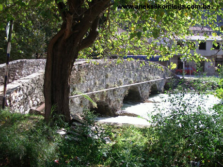
Bridges
“The
bridges of Stolac have certain features in common. Though built over a period
of at least at least three hundred years, all have round or segmental arches,
rather than the classic Turkish pointed arch. All are of rough-hewn,
semi-dressed stone. They lack the typical grade line rising from both banks to
the highest point; in two cases the grade line is effectively flat, in one it
is segmental, and in one it has three different gradients – in each case,
therefore, it is atypical for the date of the structure. These bridges also
lack the korkaluk [parapet] of stone slabs, and even have no string
course, with one exception. The powerful local architectural tradition,
however, never created designs that might have become the standard; they are
presented in their full vitality, shaped by mediaeval romantic and early
Turkish forms in their own specifically organic expression.”(15)
The
bridges of Stolac, in order proceeding downstream, are(16):
The
Ćuprija in Begovina
The most
recent of the three larger stone bridges in Stolac is undoubtedly the one in
Begovina, built in the late 18th or early 19th century when a branch of the
Rizvanbegović kapetan family(17) moved from Vidoški Grad and built an odžak [manor]
upstream on the Bregava on the eastern edge of the town. The whole area then
became known as Begovina after the manor.
Most of
the Rizvanbegović house was on the left bank, but as the family increased in
size, some of its members built themselves houses on the right bank too. The
Begovina bridge was therefore needed primarily to link the houses of this
powerful family, and it was the Rizvanbegović’s themselves who looked after it
and carried out necessary repairs right up to the Austro-Hungarian occupation.
This
bridge too has five arched openings, like the Ćuprija [see below], but neither
in its masonry nor in its state of preservation can it be compared with its
earlier model. The sloppy construction of the decadent stage of Bosnia and Herzegovina’s
oriental-influenced architecture did not last long. The bridge was soon a
semi-ruin, and was repaired using the crude approach of modern times, with
solid concrete and no trace of feeling for the aesthetic value of the
structure; nowadays the concrete prevents one from appreciating, even in rough
terms, what the Ćuprija in Begovina originally looked like.
The
arches of the bridge were an uneven oval in form; this irregularity was perhaps
not so marked initially, but as time passed, subsidence and deformation made it
ever more pronounced. The two arches by the right bank were demolished after
World War I, and instead of being reconstructed using appropriate materials,
the demolished sections were cobbled together with concrete. Concrete was also
used to patch up the lower parts of the piers, and it is impossible now to say
what they might originally have been like. A characteristic of the bridge is
that the first pier by the left bank is much wider in section than the others,
as a result of which the first opening by the left bank appears separate from
the rhythm of the other arches.
The grade
line is almost flat. There is no string course or korkaluk, but instead a
concrete parapet rising straight from the spandrel walls in the same plane.
On the
upstream side an open water channel was laid over the bridge, still further
narrowing and disfiguring the bridge.
The
visible masonry areas of the bridge are of rough-hewn stone, with the mortar in
the surface joints almost completely washed out. The stone of the arches is of
rather better finish.
The
arches are almost equal in span, ranging from 3.85 to 4.10 m, with the
exception of the arch by the left bank, which has a span of just 3.20 m. The
piers are each 1.75 m thick, with the exception of the one by the left bank,
which is 3.70 m thick. The roadway is 2.65 m thick, each railing is 15 cm
thick, and the overall length including the approaches is 35.5 m.
The
bridge is now used only by pedestrians, on account of its poor structural
condition and its narrow roadway.
The
interventions on the bridge which, as described, have disfigured it with
makeshift concrete repairs, were certainly necessary for its survival. However,
they have turned this historic structure, the value of which as part of the
surviving Begovina complex was incontestable, into something of which the
authenticity has been serious compromised and the aesthetic values largely
lost.
The Sara Kašiković
Bridge
The
bridge is on a right-hand branch of the Bregava above the Ćuprija as one makes
for Begovina. It is a single-arch bridge with a segmental, almost semicircular
arch. It was built of semi-dressed stone, of rather better finish in the
barrel, but rougher and less even in the spandrel walls, where it is covered to
a greater extent in mortar.
On the
downstream side, above the prominent keystone, is a built-in plaque with an
inscription in Cyrillic relating that this is the Sara Kašiković
Bridge, and that it was
built in 1896. The spandrel walls and parapet form a single mass with a slight
angle in the middle.
The
bridge joins the road running parallel with the river with the gardens on the
opposite bank. The two banks are at different levels, as a result of which a
number of steps, also made of stone, lead down from the bridge to the gardens
on the left bank. The bridge is a purely private one, which is why two cut
stone posts were built at the ends of the parapets on the right bank, by the
street, to which a gate was formerly fixed.
The arch
has a span of 8.40 m and a height above the water of 3.60 m. The arch is 40 cm
thick. The roadway is 1.87 m wide, the parapet walls are each 37 cm thick, and
the overall length of the bridge with the gate and steps is 12.5 m.
Though
built at the end of the last [19th] century, during the Austro-Hungarian
occupation, it was built entirely in the established traditional form of the
local vernacular architecture and was undoubtedly the work of a local mason. Interestingly,
as far as we known, it is the largest bridge built for purely private use. For
this reason it had gates to close the bridge at each end.
The
Ćuprija (Inat Ćuprija)
There is
a bridge in the centre of the town that has no name – the people of Stolac
simply call it Ćuprija, the Bridge. Furthermore, they also call the surrounding
area Ćuprija, and call the mosque there the mosque at Ćuprija. As well as the
very rustic appearance of the bridge, we believe that this absence of any other
epithet suggests that this is the oldest bridge in Stolac (the others are known
as the Podgrad Ćuprija, the Ćuprija in Begovina, and so on, suggesting that
they were built later, when there was already one bridge in the town, and so
needed a distinguishing epithet).
It is not
possible to say when the Ćuprija was built or by whom, but it could even be a
mediaeval structure which, with certain adaptations and occasional minor or
major repairs, has survived as a very solid bridge to this day.
Its
rustic appearance and the absence of any stylistic detail that might direct us,
even roughly, to a certain period, and the fact that it is the oldest bridge in
a very old settlement, are sufficient to suggest this conclusion, and even to
suspect that it may stand on the foundations of some kind of Roman bridge,
though the surviving superstructure has nothing Roman about it.
The
bridge has five round arches increasing in span and rise from the banks to the
centre in a regular rhythm. The round arches are denoted on the upstream and
downstream façades of the bridge by a distinct moulding, by the arches being
markedly recessed by comparison with the spandrel walls, and by the evenly
dressed stone of the arches and barrels, contrasting with the rustic finish of
the spandrel walls themselves.
Measured
from the left bank to the right, the arches and piers are of the following
widths:
-
First arch 2.95 m
-
First pier 1.20 m
-
Second arch 3.10 m
-
Second pier 1.80 m
-
Third arch 3.75 m
-
Third pier 1.60 m
-
Fourth arch 2.90 m
-
Fourth pier 1.60 m
-
Fifth arch 2,90 m
-
Approach spans 5.00 m
-
Overall 26.80 m
The
roadway of the bridge is of an average width of 4 m, and the parapet walls are
each 45 cm thick. The upstream cutwaters range from 1.70 to 2.50 m, and the
downstream buttresses from 1.75 to 2.25 m. The second pier from the left is the
most substantial.
The
stability of the bridge is emphasized formally by the relative narrow and very
elongated piers, with sharp cutwaters upstream and unevenly blunted buttresses
downstream projecting beyond the basic contours of the structure to a greater
extent than any other example we have examined here. These piers have recently
been patched up with cement mortar, which regrettably conceals their stone
structure, so that it is impossible to say to what extent their original form
has also been altered as a result.
The grade
line of the roadway rises from the banks towards the middle, but does not
follow the basic principle of a grade line roughly in the middle; instead, it
forms a slight, fairly regular arch, outlined in the view of the bridge by the
top line of the parapet.
The
spandrel walls, which are of rough-hewn stone fairly extensively covered with
mortar and overgrown with greenery, have no mouldings or structural details
except for the moulding above the arches. There is no string course or parapet;
instead, the spandrel walls rise above the roadway to form a parapet wall.
Though
the oldest of all the bridges in Stolac, it is now also the most stable and
solid bridge in the town.
The
Stolac Ćuprija, spanning the river in its extreme simplicity of outline and
detail, seems one with the terrain and the picturesque environs, where many
older buildings have survived, and above all, its scale. It impresses the
observer with the power of its visual expression, in which authority of purpose
and the stereotomic self-containment of its functionally coherent form are the
basic principles of the composition.
The Lučki
(Luka) Bridge
The Lučki
bridge is a footbridge built after World War II, using modern materials
(reinforced concrete).
The
bridge has two piers, and an almost completely level grade line.
The New
Bridge
The
bridge was built after World War II, using modern materials (reinforced
concrete).
The
erection of this bridge relieved the Podgrad ćuprija of heavy goods vehicle
traffic; the bridge is now the main entrance to Stolac from Mostar and
Berkovići.
The
footbridge by the Šaric summer residence
The
bridge is one of the small crossings over side channels, where the current is
mainly steady and innocuous, which is reflected in particular in the height of
the three arches, barely more than three metres, while the overall length of
the bridge is almost 15 metres. Interestingly, this footbridge does not span
the channel at right-angles, but at an oblique angle, with even the arches
echoing the direction of the current lying at an angle below the
superstructure.
The
bridge leading to the Ada
This is
on a left-hand channel of the Bregava, below Vidoški Grad, upstream from the
Podgrad bridge, connecting the eyot, where the interesting old houses of the
Ljubović and Jašarbegović families still stand, with the town’s high street.
It is a
small bridge with three arches of which the span is 2.40 m and two piers 1.70 m
in width; its overall length including the approaches is 13.70 m, and its width
is 3.10 m. Since the water level in this channel of the Bregava does not rise
significantly even in winter or after heavy rain, the arches are small and form
low segments over the water. Like the other bridges of Stolac, it is of
rough-hewn stone, rather better finished for the arches and less so for the
spandrel walls, which merge straight into the parapet wall as a single entity.
The
footbridge is completely flat, as is its parapet wall.
It is
impossible to say with certainty when this footbridge was built, as its formal
elements provide no basis for dating it. It would seem, however, that the eyot
was already inhabited in quite early times, and the architectural details on
some of the buildings, especially the windows, suggest a 17th century date at
the latest. There is no reason to suspect that the footbridge is any later in
date, since it would have been necessary to have a crossing to the eyot from
the moment the first houses were built there.
The
bridge by the Podgrad mosque (Ali-pasha mosque)
This
bridge is also one of the smaller crossings in Stolac. It is, however, below
the main road that was widened at the end of the last [19th] century to more
than seven metres, which almost completely destroyed the original impression
created by this bridge.
The
bridge is of hewn stone, and has three arches made of ashlar.
The Podgrad
ćuprija
The
Podgrad bridge is downstream from the Ćuprija, and is the first bridge in
Stolac to be reached when entering the town from Mostar and Čapljina via
Domanovići. It clearly acquired its name from its location, since it stands at
a point dominated by the Stolac fort, or Vidoški Grad as it is known in
historical sources. It is clear that it was built after the Ćuprija, not only
from its name but also from the urban structure, in which the residential
quarters and public edifices are all clearly oriented towards the Ćuprija,
whereas this bridge remains a kind of entrance to the town. A further argument
for a much later date is the fact that the settlement around it developed
mainly on the left bank, which means that the necessary limited symbiosis of
the bridge with the townscape did not arise.
Who built
the bridge and when is not known, any more than it is for the other bridges of
Stolac, but on the basis of certain structural comparisons we are inclined to
the hypothesis that it is no older than the early 18th century. The keystone of
one of the arches on the downstream side bears the date 1898, which is clearly
the date when the bridge was repaired during the Austro-Hungarian period, not
the date when it was built.
That was
the year when the occupying authorities widened the bridge on the downstream
side by rather more than two metres, to cope with modern traffic. The line of
this enlargement can clearly be seen under the barrels of the Podgrad Ćuprija. There
is no doubt that the bridge became more utilitarian as a result, but equally no
doubt that it lost much of its beauty and elegance.
The
Podgrad bridge now has two arches of differing sizes, supported by a pier in
the river and two abutments on the banks, which are higher here, and the river
bed is deeper. As a logical consequence, the rises of the arches are rather
higher to bring the grade line to the same level as the river banks.
The
differing spans and heights of the arches gives the bridge an asymmetrical
appearance. The pier has a triangular cutwater upstream, which is not
particularly pronounced in the overall image of the bridge. The unequal span
but roughly similar height of the arches give the impression of a makeshift or
clumsy design, or at least, an absence of harmonious proportions as the basis
for a harmonious impression. The smaller arch, by the left bank, has a span of
five metres and the larger, by the right bank, of eight. The pier is 2.5 m
wide, as is the upstream cutwater. The roadway is 4.80 m wide, the parapet
walls are each 35 cm wide, and the overall length of the bridge including the
approaches is about 26.50 m.
The
arches are of tufa, with a limestone keystone on the downstream side. The
voussoirs are of regular radial form. The spandrel walls are slightly
emphasized by a differentiation of surface, which underlines the difference in
material – unlike the arches, which are of tufa, the spandrel walls are of
white limestone cut into fairly regular blocks, with prominent pointing. This
is particularly evidence on the downstream façade; the upstream side, which is
more heavily patinated, is losing the contrasting colours that indicate the
different materials used. The use of the materials and the outline of the
larger arch are somewhat reminiscent of the Kozija [Goat] Bridge in Sarajevo, which dates in
its present form from the early 18th century. Though this bridge in Stolac is
far inferior to the Sarajevo bridge, we are inclined to date them to much the
same time, and to state that the Podgrad bridge is also the work of local
masons, since we already know that all the bridges in Sarajevo that were built
or rebuilt in the 18th century were the work of masons who mostly came from
Herzegovina.
The grade
line of this bridge is emphasized by a moulded string course which runs roughly
horizontally between the centres of the arches, at which point it angles down
towards the river banks. A similar treatment of the string course is to be seen
again on the Arslanagić
Bridge near Trebinje. It
is impossible to say whether there was once a stone slab korkaluk above the
string course, as on most old bridges; the parapet wall is now of rather crudely
dressed stone of varying heights on the upstream side and of large ashlar
blocks on the downstream side.
The
bridge in Polje
There is
no reference to this bridge in Čelić and Mujezinović's, Stari mostovi u
Bosni i Hercegovini. It is not known when this bridge was built, but it was
probably in the 19th or early 20th century, given the materials used, the
structure, and the repairs that can be seen on the bridge.
It was
built just by the mill in Polje, following the established traditional forms of
local vernacular architecture. It has four arches, with the barrels built of
ashlar blocks in horizontal courses; the voussoirs of the semicircular arches
are recessed by about 3 cm from the spandrel walls, which are of semi-dressed
stone.
Neither
the parapet nor the original grade line of the bridge has survived.
The grade
line is almost completely level, and the roadway is now decked with concrete. It
is fitted with a makeshift railing of iron posts and wire.
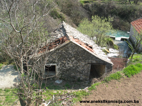
Flour mills and fulling mills
Flour mills
Identified
by the name of the various flour-mill owners, these are mainly of the same type
of building, without any great differences in structural system.
The way
the flour mills were built was dictated entirely by their function and the need
for their very existence; these simple but essential merchant structures are
free of all superfluity, from the whole to the minutest detail, without any
decoration. The vernacular builders set these small buildings in their stunning
natural surroundings without feeling the need to express their own skills in
design and architectural expression. Architecture here is the handmaiden of
need, a necessary means for achieving the basic aim – functionality.
Their
arrangement in the area depends solely on the force of the current; they were
built where the current is moderate, to ensure a steady source of power to turn
the mill wheels, the sole determinant of their position in the urban fabric.
“Anyone
passing through Stolac with a degree of interest cannot but sense the direct
link between these bridges and primitive, purely utilitarian structures without
the least pretension to style such as the mills on the same river. These flour
mills, of which there were once many in Stolac and of which a certain number
still survive, display a strict functionality of form, the limitations of the
local builder's attachment to stone and round arches as their most logical
structural form. As many as ten identical arched openings form a long,
rhythmical succession over the mill-races, supporting the heavy millstones....
But one should not imagine that he made arches of lesser span under the mills
because he was afraid to make them wider; rather, it was because the diameter
of the mill stone, the primary machinery, dictated the span of the mill-race.”(18)
The flour
mills on the river Bregava in Stolac are single-storey buildings, always raised
above water-level and always with gabled roofs. The way they are placed,
dictated by the operation of the mill wheel, gives the impression as one looks
at the downstream façade that they have two storeys, with the upper storey
resting on the arches of the lower.
The
interior of the mill is a single space housing the mill wheels. The length of
the building depends on the number of mill wheels, with one wheel in each of
the arches over the river. The mill wheels are set equidistant from one
another, a rhythm echoed on the façades by the arrangement of the arches.
“Beside
the mill was accommodation for the miller and his assistant, where there was a
hearth and a fireplace or stove for heating. There was also a stable by the
mill for packhorses.”(19)
The
miller's room was at the entrance to or the end of the mill.
The flour
mills were built of limestone(20) in lime
mortar. The walls were of hewn stone, and the quoins were usually of ashlar,
which was also used for the window and door frames and the barrels of the
arches. Traces of plaster are still to be seen on the entrance façades, and it
is likely that these were the only façades to be plastered. The walls were
plastered on the inside, as suggested by the remains of plaster on the walls of
most of the mills.
The mills
usually had windows only on the downstream side, with only the occasional mill,
such as the Elezović mill, fitted with a single upstream window. In some cases
the entrance façade had a window to light the miller’s room.
The
windows were usually rectangular, varying in size from mill to mill. They
always had wooden frames and a wooden lintel, and were fitted with iron
grilles.
Inside,
there were niches in the walls, usually on the downstream side, sometimes
double and sometimes single, rectangular or square, which were probably where
lanterns, candles and so on were placed to light the interior of the mill. Some
flour mills also have a niche in the entrance wall.
The
fireplace still survives in some of the flour mills and fulling mills above
Poplašići (the flour mills and fulling mills in Do).
The roof
structure is of wood, of simple design, with rafters fixed to a horizontal tie
beam and cross stays resting on the wall plates of the façade walls of the
mills. The eaves are kept to a minimum. The roofs are clad with stone slabs(21).
The flour
mills in Stolac were built above the level of the main river channel. The water
that powered the mill wheel was directed along an artificial channel built to
direct the water away from the main river channel. The channel was in effect a
mill pond, designed to create the fall needed to turn the wheel, with a stone
and mortar barrier or sluice gate built with lime and terra rossa. The
water flowed from the dam to the mill wheel along the mill race, built in the
old days from thick pine planks or stone and more recently of poured concrete,
laid at an angle sufficient to create the necessary water power – 30 to 45
degrees – and also narrowing towards the base.
The
machinery that powered the mill was mounted under an arched stone ćemer [vault]
below the floor of the mill, a space known as the izba, which contained the plazina
or kobila [axle] that turned the wheel. This was made of red oak, which
is very water-resistant. The wheel was originally wooden, but more recently
some mills were fitted with 9 to 17 iron buckets taking the force of the water.
The spindle or arbor was part of the wooden axle by means of which the rotation
of the wheel was transmitted to the top stone or runner, which did the actual
grinding. An iron spindle known as the senj passed through the floor of the
mill and the hole in the lower mill stone or bed to the top mill stone or
runner, which is mounted onto this spindle by a horizontal peg. The water from
the mill race fills the buckets of the mill wheel, its force turning the wheel
and transmitting it to the mill stone. The mill stone is circular, with a
diameter of 100 to 110 cm and a thickness of 15 to 30 cm. The wooden hopper
above the mill wheel containing the grain to be ground is triangular in
section, with the grain falling through the narrow slot at the base at a rate
controlled by a slipper, and onto the bed stone. The gap between the bed and
the runner is regulated by a lever to obtain the required fineness of the
flour, which falls to the floor between wooden planks that retain it in place.
This
flour-milling machinery has undergone no major alterations in the three hundred
years since the mills were first described. The only recent innovation is the
use of ball-bearings and an iron wheel(22).
Some of
the flour mills still have their mill wheels and wooden hoppers.
Fulling mills
“In
Stolac there are water mills, // In Stolac there are fulling mills, // Flour
mills milling, and fulling mills fulling.” This old song about the fulling and
flour mills tells us clearly that the flour and fulling mills were inseparably
linked. Wherever there was a flour mill, there too would be fulling mills and
troughs, if not together, then somewhere nearby. When a peasant set off for the
mill, he would take two pack horses, one laden with grain, and the other with
woollen blankets and homespun to be washed and fulled.”(23)
Fulling
mills, the smallest of the stone buildings on the river Bregava, echo the flour
mills in concept and placing in the townscape, forming a complex with the flour
mills.
“There
were many fulling mills in Stolac on the river Bregava, all of which were in
operation to the end of the last century (to 1992). They were installed by the
river or on eyots, and were made of timber. They were primitive devices for
fulling and felting homespun cloth.... The fulling mills were usually installed
in buildings, but some were in the open air. The fulling mill buildings were
built of limestone and mortar, with a roof of stone slabs or tiles. The lower
storey contained the fulling mill, and the upper a shop with a wing for drying
the cloth. The shops usually had two rooms, with a hearth in one and the other
used by customers... The water that powered the mill wheel was directed along a
separate channel which was in effect a mill pond, designed to create the fall
to power the wheel, with a sluice gate at the end. The mill pond was built of
various materials: stone, mortar, lime and terra rossa. The sluice gate
had a number of vents. The water flowed along the wooden mill race to the mill
wheel, which powered all the fulling machinery. The mill wheel was mounted on a
shaft resting on a wooden block to which the water was led along the mill race.
The wheel was fitted with cams or trips which raised the fulling stocks. The felloes
of the water wheel were fitted with buckets, three on each felloe, making
twelve in all. The cloth was placed in an oak trough and struck by pairs of
stocks each working alternately. Each stock weighed about 90 kg, with the face
of the mallet ending in three teeth. The shank of the stock was attached to a
beam in the upper part of the fulling mill. These beams were made of maple
wood, which makes a pleasant, quite melodious sound. When the stocks were
working, the maple beams sounded like the drums of war, and could be heard up
to three kilometres away. The pounding of the stocks, the roar of the Provalije
waterfall, the smell of the flour in the flour mills, and the bright colours of
the kilims, mats, ćenars, blankets and carpets combined to create the
particular charm familiar to those who knew what the Stolac čaršija was. It was
a feast for all the senses, not only the eyes and the soul. The fulling stocks
were made of four different kinds of wood: locust, oak, maple and mulberry.
I said at
the beginning that the fulling mills were used to full and felt woollen
homespun cloth. The types of homespun processed in the mills were those known
as sukno and raša, woven from four-ply thread, klašnja [woollen
cover] woven from 8 or 9-ply thread, gunj and guber [a rough,
heavy blanket, a horse blanket] woven from two-ply, himbulja
[haircloth], kabanica [a heavy cloth], and bičalj [unidentified:
Trans.]. All these were made of wool, and were used by the rural population for
their essential needs.”(24)
The
fulling mills were thus purely commercial structures, always associated with
flour mills, usually forming a small group of two or at most three buildings,
one of which would be the “stuparska radnja” or fuller’s shop, in which
business deals were struck. The other structure would be the fulling mill
itself, with a cloth-drying area on the upper floor or used for some other purpose
in summer. The structure of the fulling stocks, with their wooden foot or stock
and metal shaft, was outside the building, in the water, but there are also
examples where the water enters large stone “cauldrons” in the part of the
building at water level and protected from the elements.
Outwardly,
these structures are very simple, with hewn stone walls and an upper floor with
wooden floor joists and roof timbers. The roof is clad with stone slabs. The
walls are plastered on the outside, leaving the evenly cut stone exposed on the
arches over the water emerging from the “cauldrons” below. They are absolutely
plain and undecorated, of a purely utilitarian nature.
The
following mills or flour mills and fulling mills together are now to be seen in
Stolac, listed in order heading downstream:
Flour
mills and fulling mills in Do or above Poplašići
This
complex, on the right-hand side of the river, consists of a flour mill, trough,
fulling stocks and ancillary building.
The mill
is roughly square in plan, measuring 4.66 x 4.79 m. The lie of the land means
that, unlike every other mill, there is another room above the mill in Do, in
which the fireplace still survives. A flight of concrete steps now leads to
this room. The mill has two mill wheels.
The
ancillary building has two stories with two separate rooms. It measures roughly
9.50 x 5.00 m.
The
fulling stocks and troughs are in the open.
The
Rizvanbegović flour mill
This is
on the left-hand side of the river, upstream from the Begovina residential
complex. Measuring roughly 4.60 x 7.50 m, it has three mill wheels.
Complex
of flour mills and fulling mills with troughs at Propa (or the mill above the
Sara Kašiković bridge or Batan mill)
This
complex, on the right-hand side of the river, consists of a flour mill, a
fulling mill with a storeroom, and a trough.
The
complex is in two separate parts. One courtyard, by the road, contains a flour
mill, a fulling mill with a storeroom (shop) and two open-air troughs. The
fulling mill and shop, which measures roughly 8.80 x 4.30 m, is entered from
the courtyard. The mill, which measures roughly 19.00 x 5.00 m, has seven mill
wheels and a separate miller’s room by the entrance.
The other
part of the complex consists of a flour mill, fulling mill and trough.
The
fuller’s shop measures roughly 12.10 x 9.60 m.
As
Elezović notes, “There are still such premises (a shop by a fulling mill) at
Propa at the Buzaljkos’ place. One was a building by the road, with a stone
slab roof. It contained two fulling stocks, and two troughs in the courtyard. This
was owned by Sulo and Džemo Buzaljko. In the same place, but by the river
Bregava, was a stone building with a tiled roof, containing two fulling stocks
and two troughs, one in the channel under the building. These fulling mills
were owned by Adem and Džemo Buzaljko-Zmaj.”(25)
The
complex of flour mills with a fulling mill at Provalije (the (Tucaković mill,
Leto mill and drying house)
The
complex, which is on the left bank of the Bregava, consists of two mills and a
drying house.
The
Tucaković mill measures roughly 14.60 x 5.40 m, and has five arches.
The Leto
mill measures roughly 12.85 x 5.30 m, and also has five arches.
The
drying house measures roughly 6.80 x 3.10 m.
The mills
at Pogleđe
The
Elezović mill
This
stands on the left bank of the Bregava. It measures roughly 16.60 x 5.00 m, and
has eight arches.
The
Turković mill
This
stands on the left bank of the Bregava, in the Turković family courtyard. It
measures roughly 10.50 x 5.30 m, and has five arches. Inside are nine mill
wheels and the miller’s room, at the end of the mill.
The
Mehmedbašić or Behmen or Ćuprija mill
This
measures roughly 22,00 x 5,10 m, and has ten arches. Inside the mill are nine
mill wheels and the miller’s room at the end of the mill.
Remains
of the Podgrad mill
These are
on the left bank of the Bregava, very close to the Podgrad (Ali-pasha
Rizvanbegović) mosque and the Podgrad konak. They were discovered a year ago. What
remains shows that the mill had seven arches. It has survived only up to the
level of the arches.
The mill
in Polje (Vidovo Polje) or the Ošanići mill
This
stands just by the four-arched bridge. Its present condition is such that it is
impossible to tell how many arches it had, but it was probably four (which can
still be seen) or five.
Natural heritage
“The Bregava River valley is composed of the
Cretaceous and Palaeogene sediments, covered with debris and slope breccias in
the canyon, and downstream of Stolac with the alluvial deposit (the Vidovo
Polje). Faults of reverse type and the folded structures of the Dinaric
direction give a tectonic character to this area. The most rugged tectonic
element is the anticlinal form in which the canyon section of the watercourse
is cut through. The anticline is broken by a fault, which imposed the forming
of the canyon valley from the source close to the settlement of Stolac.”
“The
thickness of alluvial deposits in the riverbed ranges between 4 and 23 m. Alluvial
deposits accumulated faster after the construction of a small dam upstream from
Stolac. The limestone below the alluvium is highly karstified and water
permeable...”
“Discharge
of the Bregava springs exists owing to well-deposited alluvium (clogging layer)
through which a relatively small quantity of water percolates so that the
permanent course disappears only downstream of Stolac...”
“The
catchment area of the Bregava spring zone encompasses about 396 km2. The spring
zone consists of Bitunja Spring ... and Mali Suhavići and Veliki Suhavići... The
catchment area is divided... into two hydrogeological units. One is the direct
catchment area, which includes a huge mass of the Hrgud and Stinica mountains
located in the zone between Dabarsko Polje and the regional fault between
Ljubomirsko Polje and Stolac... The other part of the Bregava spring catchment
area, known as indirect catchment area, consists of the catchment area of
Dabarsko Polje, which includes the catchment areas of Trusinsko and Lukavičko
Polje... All water from Dabarsko Polje discharges through a few large ponors
(swallow holes). The largest one is Ponikva ponor. Additionally, a small
percentage of water from Fatničko Polje is discharged through the spring zone
through the Bitunja-Suhavići.”(26)
The water
quality in the Bregava varies. At the source, it is oligosaprobic to slightly
betamesosaprobic, whereas in Stolac it becomes oligosaprobic with a tendency to
deteriorate. At the mouth it is betamezosaprobic. In every case, the water of
the Bregava is alkaline, with a moderate salt content and high oxygen levels(27).
This
region, with its towns and villages of endemic forms and other characteristics
of a sub-Mediterranean climate, is of great interest. The plant cover
determines the appearance of a region. The link between people and the plant
cover is obvious. First come green plants which, as producers of organic food,
constitute the basic food of every biocenosis. Underwater plants enrich the
water with oxygen, and detritus provides food for many species of animals
living in the water. Macrophytic vegetation provides support and protection,
for instance by preventing erosion as it covers the banks with its root systems
and underwater steps.
This
oasis of green in the midst of the bare karst, on which the survival of a
distinct and important fauna depends, is seriously endangered. In recent times,
the reclamation of wetlands and marshes is displacing the wetland flora and
fauna(28). The
water plants of the Bregava belong to the Potamelia order [a
phytosociological order of fresh-water plant groups], Potamion eurosibiricum
alliance, Myriophylleto-Nupharetum association. At the mouth of the
Bregava marsh plants of the Phragmition communis alliance, Scirpeto
phragmitetum and Sparganieto-Chlorocyperetum longi associations, are
to be found.
Mud-bank
vegetation of the Fimbristylion dichotomae alliance, Fibristileto-Paspaletum
association is also to be found on the banks of the Bregava, as well as flood
forest vegetation consisting of willow, Salicetum albae association,
with fourteen species, including Salix alba, S. fragilis, S. purpurea, Vitex
agnus-castis and so on. A Populion albae alliance of poplar woodland
forms the continuation of or mingles with the narrow strip of willow. The
woodlands on the banks often form the habitat for various birds.
Another
interesting type of vegetation is the semi-cave vegetation of the order Adiantetalia,
Adiantum capillus-veneris-Eucladium alliance, and the species Perietaria
ramiflora. This rare and beautiful fern, known as the Maidenhair Fern,
covers certain specific habitats with its luxuriant growth. It can be found on
the banks of the Bregava below the bridges in Stolac(29).
Fifty-one
species of diatomic algae (diatomophyceae) have been identified in the
Bregava(30).
As a rule
the zoobenthos (the animal component of the benthos or organisms living on or
near the river- or sea-bed) is fairly well-developed in clean running water,
especially fast-flowing water. The bed of running watercourses forms the
habitat for members of many groups of animal organisms, on which most of this
country’s freshwater fish feed, especially salmonids(31). In Bregava, these include
Mollusca: Ancyclus fluviatilis, Oligochaeta, Hirudinea, Isopoda, Amphipoda,
Decapoda, Ephemeroptera, Plecoptera, Coloptera and Trichoptera.
The fish
population of the middle Neretva basin is mixed, giving a clue to the
distribution of the ichthyofauna in the Bregava, which joins the Neretva. Among
endemic species that have been registered is the Neretva soft-mouth trout (Salmothymus
obtusirostris oxyrhynchus), which is found in the Bregava. Another endemic
found in the Neretva is the nase, Chondrostoma knerii, which may also
form part of the population of the Bregava. Other species inhabiting these
waters are the river trout, marble trout, dentex, chub, bleak, minnow,
bitterling, eel and grey mullet. The spawning time and spawning runs of fish through
water courses depend on numerous factors. The presence of dams, fishing and the
discharge of waste water into water courses may have a considerable impact on
the presence and survival of ichthyofauna in these waters.
Insects
are also often present near water. The following endemic species have been
registered in Stolac: Barbitistes yersini, Poecilimon elegans, Platycleis
orina and Ephippiger discoidalis(32).
3. Legal status to date
The
Regional Plan for the Republic of Bosnia and Herzegovina to 2002 listed the
townscape of Stolac (the fort, the townscape below with three mosques, a
hammam, three bridges, the Begovina and several houses) as a Category I
monument.
The
Regional Plan for the Republic
of Bosnia and Herzegovina
to 2002 listed the Ćuprija, the Podgrad bridge and the bridge in the Begovina
in Stolac as Category II monuments.
The
Regional Plan for the Republic of Bosnia and Herzegovina to 2002 included the Bregava
valley, Stolac Municipality, area 1.5 ha, among the
most important natural sites, listed and valued as of local value with the
strictest protection regime, level II.
At a
session held on 14 July 2000 the Commission to Preserve National Monuments
adopted a decision to add the mills and the bridge on the Ada
to the Provisional list of National Monuments of Bosnia and Herzegovina
under serial numbers 590 and 591.
4. Research and conservation and
restoration works
No
conservation or restoration works have ever been carried out on the properties
in the natural and architectural ensemble under the supervision of the heritage
protection authority.
The
properties have been repaired when necessary by the owners themselves,
resulting in inappropriate interventions (the introduction of new, incompatible
materials such as concrete, cement and tiles). These interventions have not,
however, led to structural or formal alterations to the buildings nor have they
impaired their value (all the interventions are largely reversible).
In the 1940s
some of the bridges in Stolac were surveyed. The technical documentation is
housed in the Archive of Herzegovina.
Research
works were carried out on six of the bridges on the river Bregava by Džemal
Ćelić and Mehmed Mujezinović, who published their findings in their book Stari
mostovi u Bosni i Hercegovini. This listed all the changes to the bridges
as regards their structure to upgrade them to meet contemporary traffic
requirements. Works of this kind have been carried out on the Ali-pasha bridge,
the Podgrad Ćuprija, and the Begovina bridge; as a result of the widening of
the roadway over the bridges, all three have lost their harmony and elegance of
appearance.
Prior to
2004 the flour mills and fulling mills were documented in part, in
that the ground plan and elevation of a typical mill was drawn up.
In 2004,
as part of its campaign to train students, the Commission surveyed all the
mills that were accessible at the time in Stolac. Supervised and led by
experienced architects, the students drew up site plans, ground plans,
cross-sections and elevations, along with drawings of typical features, of all
the complexes of flour mills with fulling mills and troughs described above,
with the exception of the mill at Polje (the (Ošanići mill).
In March
and April 2007 the Commission cleared seven flour mills with fulling
mills and three bridges in Stolac of vegetation, as part of the project
entitled Programme for the on-going protection, presentation and integration of
the cultural, historical and natural heritage into the tourism sector of the
Herzegovina region, largely funded by the European Union.
The mills
in the complex of flour mills and fulling mills with troughs at Propa (the mill
above the Sara Kašiković bridge, the Batan mill) have recently been renovated
and restored to working order by the owner.
5. Current condition of the
properties
The flour
mills and fulling mills in Stolac are in extremely poor condition, the result
of minor war damage, the absence of routine maintenance, and disuse.
Only ten
or so of the twenty or more mills said by Elezović to have been in Stolac in
the 18th century now remain(33). Some
have fallen into complete ruin, with only vestiges remaining.
Only one
mill and trough has been restored and is in regular use (the mill in the
complex of flour mills and fulling mills with troughs at Propa (the mill above
the Sara Kašiković bridge, the Batan mill).
All the
other mill buildings are in a poor state of preservation and exposed to the
elements. In addition, rubbish is constantly being dumped inside the mills. The
damage to the mills takes the form of the absence of or serious damage to the
roof structure, cracks in the walls, courses missing from the walls, and
vegetation covering whole areas of the buildings. The mill races are overgrown
with vegetation and many are choked with rubbish. The channels themselves are
in poor condition and overgrown with weeds. Inside, the mills are in poor
condition, with broken wooden hoppers and mill wheels removed from their
bearings, but all the elements survive.
Though
the Commission to Preserve National Monuments cleared most of the mills of
vegetation and rubbish, the absence of routine maintenance and the owners' lack
of interest in restoring their properties has resulted in the mills become
overgrown once again.
Damage to the various mills
Flour
mills and fulling mills at Do or above Poplašići
The
complex is in relatively good condition. Structurally, the best-preserved
building is the fuller’s shop. The building has undergone certain alterations –
the addition of access steps and a terrace and replacing the original roof
cladding with different materials. The building is not in use.
The mill
is covered with self-sown vegetation and the roof timbers are at risk of
collapsing. The walls are in relatively poor condition.
Interventions
carried out during the past fifty years take the form of the addition of
concrete steps and a terrace and the replacement of the roof cladding with
tiles.
The
Rizvanbegović mill
The mill
is in relatively poor condition. Access is difficult on account of the
vegetation covering the path and the mill itself. The roof timbers are exposed
to the elements where the roof cladding is missing, and are thus affected by
damp. The walls are in fairly good condition.
Complex
of flour mills and fulling mills with troughs at Propa (the mill above the Sara
Kašiković bridge
of Batan mill)
This is
the only complex of flour mills and fulling mills with troughs in Stolac that has
been partly restored and is in use.
The flour
mill and two open-air fulling troughs have been restored by the owner. No
interventions have been carried out that might have irreversibly damaged the
appearance or form of the building, even though it was restored without the
supervision of the heritage protection authority. Inside the building, all the
equipment needed to grind all types of grain has been restored and the building
has been restored to its original use. It is now the only mill operated in the
traditional way by a water wheel.
The other
buildings in the complex have not been restored. Next to the restored flour
mill is a fulling mill with a shop, where the elements of the fulling stock are
fairly well preserved. The roof structure over part of the building is at risk
of falling in; the rest has already done so. The walls are in fairly good
condition.
The
fuller’s shop is in rather poor condition, and access is difficult on account
of the growth of vegetation. The roof structure over the front of the building
is at risk of falling in. The walls at the front of the building are in fairly
good condition. The rear of the building is in ruins, with the roof gone and
the walls in ruins down to floor level.
Complex
of flour mills with a fulling mill at Provalije (the Tucakovića mill, the Leto
mill and the drying house)
The
complex is in extremely poor condition.
All that
survives of the Tucakovića is the walls, which are in ruins down to floor level
in places, and which are overgrown with vegetation throughout.
The Leto
mill is in better condition than the Tucaković mill. The roof has collapsed in
the middle of the building, and the rest of the roof is at risk of falling in.
The walls are in relatively good condition and are covered with ivy.
The
drying house is the best preserved building in this complex. The roof
structure, roof cladding and walls are in very good structural condition. The
building is closed.
The mills
at Pogleđe
The
Elezović mill
The
Elezović mill is in quite poor condition, since the roof has fallen in
completely over part of the building, which is therefore exposed to the
elements, and the rest of the roof is in imminent danger of falling in too. The
walls are in relatively good condition, and partly covered with ivy. The
interior has been completely destroyed.
The
Turković mill
The
Turković mill is in relatively good condition, and the roof structure is
intact. The walls are in quite good condition. The interior is damaged. The
building is in use as a storeroom.
The
Mehmedbašić or Behmen or Ćuprija mill
This mill
is in quite poor condition, since the roof has fallen in completely over part
of the building, which is therefore exposed to the elements, and the rest of
the roof is in imminent danger of falling in too. The walls are in relatively
good condition, and partly covered with ivy. The interior has been completely
destroyed.
Remains
of the Podgrad mill
The
remains of the Podgrad mill were discovered in the latter half of 2008. It
has survived only up to floor level.
The mill
in Polje (Vidovo Polje) or the Ošanići mill
The mill
in Polje has undergone the most drastic changes of all the surviving mills,
since the mill race has been filled in and the water therefore no longer flows
under the mill. At some stage the mill was also partitioned into several rooms
inside. All that remains of the mill is the partly visible stone arches.
Bridges
In the
structural sense, all the bridges in Stolac have survived and are in use. The
Podgrad bridge, Inat Ćuprija, the Begovina bridge, the Ali-pasha bridge and the
bridge in Polje (the Ošanići bridge) are all still used for road traffic, while
the remaining three lesser bridges, the bridge on the Ada, the Sara Kašiković
bridge, the bridges by the Šarić summer residence, are used for pedestrian
traffic.
All the
bridges show signs of moss and lichen, and their footings are overgrown.
Later
interventions to some of the bridges have significantly altered their original
appearance.
Lack of
routine maintenance has resulted in major damage to the structure of some of
the bridges.
The Begovina
Ćuprija
The
appearance of the bridge was seriously compromised by unprofessional works
carried out after World War II.
The two
arches by the right bank (destroyed during World War I) were rebuilt in
concrete. Damage to the bridge was repaired using concrete, in a way that makes
it impossible to identify the basic form of the piers.
The
parapet walls and roadway are also concrete.
An open
concrete water channel has been added across the bridge on the upstream side.
The
bridge is used by pedestrians and also by small passenger vehicles.
The Sara Kašiković
Bridge
The
bridge is kept regularly maintained. The top course of the parapet wall was
recently restored and the joints were repaired.
Ćuprija
(Inat Ćuprija)
After
World War II the piers were repaired using cement mortar, covering the original
stone structure.
The
structure of the bridge is in relatively good condition.
The
mortar has fallen away from the joints in places, impairing the stability of
the stone blocks, especially on the parapet. The spandrel walls are covered
with moss.
Pipes
have been added to the downstream side of the bridge.
The
footbridge by the Šaric summer residence
The
bridge is in relatively good condition.
There is
no railing or parapet.
Lack of
maintenance has resulted in the mortar falling away from the joints or
deteriorating in places, impairing the stability of the stone blocks. The
spandrel walls are partly covered with moss.
The
roadway is asphalted.
The
bridge leading to the Ada
The
bridge is in relatively good condition.
Lack of
maintenance has resulted in the mortar falling away from the joints or
deteriorating in places, impairing the stability of the stone blocks.
Part of
the parapet on the upstream side has collapsed.
The
spandrel walls are partly covered with moss. The roadway is asphalted.
The
bridge by the Podgrad (Ali-pasha) mosque
The
bridge is on the main road that was widened by almost seven metres at the end
of the 19th century, which almost completely destroyed the original appearance
of the bridge.
In
addition, lack of maintenance has resulted in the mortar falling away from the
joints or deteriorating in places, impairing the stability of the stone blocks.
The
arches and spandrel walls of the bridge are covered with ivy.
The
Podgrad ćuprija
This
bridge underwent alterations during the Austro-Hungarian occupation, when it
was widened by two metres.
The
surroundings of the bridge are overgrown, partly concealing the bridge.
The
bridge is in relatively good condition. The footings of the piers and the
parapet are covered with moss. The mortar has fallen away from the joints or
deteriorated in places, impairing the stability of the stone blocks, especially
on the parapet.
The
roadway is asphalted.
The
bridge in Polje
The bridge
lost its original roadway and parapet as a result of works carried out at some
unknown date. All that is now visible are the arches of the bridge.
The grade
line is now almost completely flat, and has a concrete surface, with a
makeshift railing of iron posts and wire.
6. Specific risks
-
Neglect and lack of
maintenance of the properties in the natural and architectural ensemble, which
could result in some being lost altogether.
III – CONCLUSION
Applying
the Criteria for the adoption of a decision on proclaiming an item of property
a national monument, adopted at the fourth session of the Commission to
Preserve National Monuments (3 to 9 September 2002), the Commission has enacted
the Decision cited above.
The
Decision was based on the following criteria:
A. Time frame
B. Historical value
C. Artistic and aesthetic value
C.iii. proportions
C.iv. composition
C.v. value of details
D. Clarity
(documentary, scientific and educational value)
D.ii. evidence of historical change
D.iv. evidence of a particular type, style or
regional manner
D.v. evidence of a typical way of life at a
specific period
E. Symbolic value
E.iii. traditional value
E.v. significance for the identity of a group of
people
F. Townscape/ Landscape value
F.i. relation to other elements of the site
F.ii. meaning in the townscape
F.iii. the building or group of buildings is part
of a group or site
G. Authenticity
G.i. form and design
G.ii. material and content
G.iii. use and function
G.iv. traditions and techniques
G.v. location and setting
The
following documents form an integral part of this Decision:
-
Copy of cadastral plans
-
Copy of land register
entries
-
Drawings – site plan
-
Copy of technical
documentation of the bridges surveyed in 1940, property of the Archive of
Herzegovina
-
Drawings of the condition
of the mills with the fulling mills and troughs in 2004 by the Commission to
Preserve National Monuments
-
Photographic documentation
from the preparation of the decision (December 2007 and April 2009).
Bibliography
During
the procedure to designate the natural and architectural ensemble of the river
Bregava with mills, fulling mills and bridges as a national monument of Bosnia
and Herzegovina the following works were
consulted:
1927 Hasandedić, Hivzija. Muslimanska bastina u istocnoj
Hercegovini (The Muslim Heritage in Eastern
Herzegovina)
1998 Celic, Džemal and Mehmed Mujezinović. Stari mostovi u Bosni i
Hercegovini (Old Bridges in BiH). Sarajevo: Sarajevo Publishing, 1998
2005 Elezović, Muhamed. “Stolačke stupe” (The Fulling Mills of
Stolac), periodical Most, no. 193 (104 – new series), Yr XXX December
2005
Elezović,
Muhamed. Stolačke mlinice (The Mills of Stolac)
//http:www.geocities.com/stolacbridgebuildings
(1) Čelić Džemal
and Mujezinović Mehmed, Stari mostovi u Bosni i Hercegovini, Sarajevo: Cultural
Heritage Series, Sarajevo Publishing, 1998, 268
(2) Decision
of the Commission to Preserve National Monuments designating the architectural
ensemble of the Čaršija mosque and Čaršija in Stolac as a national monument of BiH,
decision no. 08/1-6-915/03 of 6 May 2003
(3) Elezović,
Muhamed, Stolačke mlinice, 1
(4) Čelić
Džemal and Mujezinović Mehmed, Stari mostovi u Bosni i Hercegovini, Sarajevo: Cultural
Heritage Series, Sarajevo Publishing, 1998, 268-270
(5) According
to the information on the granting of concessions to mills on the river Bregava
to be found in the Archive of Herzegovina, the mills were built “long ago,” as
stated by a witness before 1830.
(6) “During the
Ottoman period the summary census of the Bosnian sanjak for 872/73/1468-69
includes a reference, among settlements described as villages in the nahiya of
Dabri (an-nahiyeti Dabri), to Stolac (by the name Viduška or Vidoška),
with three vineyards, 11 households and 6 bachelor households, and an income of
4524 akças, and to the abandoned place of Stolac/Istolçe with two
vineyards and half a mill with an annual income of 500 akças. The name Viduška
was retained in Turkish sources as another name for the Stolac nahiya until the
18th century.” Gadžo-Kasumović, Azra (2001), “Stolac u Osmanskom periodu”, Hercegovina,
periodical for the cultural and natural heritage, 13-14, 23-41.
(7) Elezović
Muhamed, Stolačke mlinice
(8) Poljarević,
Ale, Arhitektura povijesne jezgre Stoca, master’s dissertation,
University of Zagreb, Postgraduate Centre Dubrovnik, January 1988, 62. The same
information is also provided by Elezović, Muhamed, Stolačke mlinice
(9) Elezović,
Muhamed, Stolačke mlinice
(10) Evliya
Çelebi refers only to the mills in Do in his description of Stolac. “Since
there are ten mills of this kazaba [Stolac] where the Do brook joins the
Bregava, they are powered by the waters of the Do.” Çelebi, Evlia, Putopis –
odlomci o Jugoslavenskim zemljama, trans. Hazim Šabanović, Sarajevo: Svjetlost, 1967, 414.
(11) Elezović,
Muhamed, Stolačke mlinice
(12) Elezović,
Muhamed, “Stolačke stupe,” periodical Most, no. 193 (104 – new series),
Yr XXX December 2005, from http://www.most.ba/104/074.aspx, May 2009
(13) Elezović,
Muhamed, “Stolačke stupe,” periodical Most, no. 193 (104 – new series),
Yr XXX December 2005, from http://www.most.ba/104/074.aspx, May 2009.
(14) Elezović,
Muhamed, op.cit. and Stolačke mlinice.
(15) Čelić
Džemal and Mujezinović Mehmed, Stari mostovi u Bosni i Hercegovini, Sarajevo: Cultural
Heritage Series, Sarajevo Publishing, 1998, 280.
(16) The
descriptions of all the bridges are from Čelić Džemal and Mujezinović Mehmed, Stari
mostovi u Bosni i Hercegovini, Sarajevo:
Cultural Heritage Series, Sarajevo Publishing, 1998, 270 – 280.
(17) A kapetan
was a type of local hereditary official exercising effective power in his kapetanija,
a feature unique to the Bosnian eyalet (Trans.)
(18) Čelić Džemal
and Mujezinović Mehmed, Stari mostovi u Bosni i Hercegovini, Sarajevo: Cultural
Heritage Series, Sarajevo Publishing, 1998, 270
(19)
Poljarević, Ale, Arhitektura povijesne jezgre Stoca, master’s
dissertation, University of Zagreb, Postgraduate Centre Dubrovnik, January
1988, 62.
(20) Limestone
is a sedimentary carbonate rock consisting of the mineral calcite, and may also
contain small quantities of other minerals: clay, sporogelite, diaspore,
hydrargyllite, limonite, haematite, quartz, zirkon, tourmaline and granite. It
is formed by deposits of the shells and skeletons of marine animals and, to some
extent, of plants. It is used as a building material and to make lime.
http://hr.wikipedia.org/wiki/Vapnenac,, accessed 17 September 2009.
[Translator’s note: this is a translation of the entire Croatian Wikipedia
article. The English Wikipedia entry for limestone is considerably more
comprehensive. See http://en.wikipedia.org/wiki/Limestone. ]
(21) Replaced
on most mills, over the years, with tiles.
(22) Elezović,
Muhamed, Stolačke mlinice and Poljarević, Ale, Arhitektura povijesne
jezgre Stoca, master’s dissertation, University of Zagreb, Postgraduate
Centre Dubrovnik, January 1988, 61, 62.
(23) Elezović,
Elezović, Muhamed, “Stolačke stupe,” periodical Most, no. 193 (104 – new
series), Yr XXX December 2005, from http://www.most.ba/104/074.aspx, May 2009.
(24) Elezović,
Muhamed, “Stolačke stupe,” periodical Most, no. 193 (104 – new series),
Yr XXX December 2005, from http://www.most.ba/104/074.aspx, May 2009.
(25) Elezović,
Muhamed, “Stolačke stupe,” periodical Most, no. 193 (104 – new series),
Yr XXX December 2005, from http://www.most.ba/104/074.aspx, May 2009.
(26) Various
authors, 2004, 43-45. “All statements contained in this document are made
without responsibility on the part of the authors, and are not to be relied
upon as statements or representations of facts; CUW-UK and ICCI Ltd do not make
or give, nor has any person authority on their behalf to make or give, any
representation of warranty whatever in relation to the contents of this
document.” [Translator’s note: the document in question is by Maksimovic, C.,
H. S. Wheater, D. Koutsoyiannis, S. Prohaska, D. Peach, S. Djordevic, D.
Prodanovic, C. Makropoulos, P. Docx, T. Dasic, M. Stanic, D. Spasova, and D.
Brnjos, Final Report, Analysis of the effects of the water transfer through the
tunnel Fatnicko Polje - Bileca reservoir on the hydrologic regime of Bregava
River in Bosnia and Herzegovina, Commissioner: Energy Financing Team,
Switzerland: CUW-UK, ICCI Limited, London, 2004. The passages in quotes are taken verbatim (with
the exception of one correction of a typo) from the document at
http://www.itia.ntua.gr/getfile/627/2/documents/2004BosniaFinalReport1b.pdf.,
where the final paragraph quoted above in fact precedes the rest of the
quotation.]
(27) Kosorić,
Đorđe, Sastav i karakteristike životnih zajednica Neretve (od Mostara do
granice sa SR Hrvatskom) za period do ljeta 1976, Sarajevo: 1977, pp. IV-115-116.
(28) Ibid.. pp.
V-2-4.
(29) Ibid., pp.
V-6-26.
(30) Ibid.,
pp.. IV-98.
(31) Ibid.,
pp.. IV-1.
(32) Mikšić,
Sofija, “Mediteranski oblici u fauni Orthoptera Hercegovine”, annual of the
Biology Institute of the University of Sarajevo, vol.33- 1980, Sarajevo: 1980,
141.
(33) Elezović,
Muhamed, op.cit.