Status of monument -> National monument
Pursuant to Article V para. 4 Annex 8 of the General Framework Agreement for Peace in Bosnia and Herzegovina and Article 39 para. 1 of the Rules of Procedure of the Commission to Preserve National Monuments, at a session held from 7 to 12 October 2003 the Commission adopted a
D E C I S I O N
I
The archaeological site of the antique-era military camp at Gračine in Humac, Ljubuški Municipality is hereby designated as a National Monument of Bosnia and Herzegovina (hereinafter: the National Monument).
The National Monument is located on cadastral plots nos. 2268, 2269, 2270, 2274, 2275, 2276, 2284, 2285, 2286, 2290, 2291, plot name Gračine, in private ownership, cadastral municipality Humac, Ljubuški Municipality, Federation of Bosnia and Herzegovina, Bosnia and Herzegovina.
The National Monument consists of the archaeological site of Gračine with antique-era military camp and the movable heritage items found on the archaeological site, now housed in the collections of the National Museum of Bosnia and Herzegovina in Sarajevo, the Museum of Herzegovina in Mostar and the Museum in the Franciscan Monastery in Humac, and registered in the inventories of finds of the museums.
The provisions relating to protection and rehabilitation measures set forth by the Law on the Implementation of the Decisions of the Commission to Preserve National Monuments, established pursuant to Annex 8 of the General Framework Agreement for Peace in Bosnia and Herzegovina (Official Gazette of the Federation of BiH nos. 2/02 and 27/02) shall apply to the National Monument.
II
The Government of the Federation of Bosnia and Herzegovina (hereinafter: the Government of the Federation) shall be responsible for ensuring and providing the legal, scientific, technical, administrative and financial measures necessary to protect, conserve, display and rehabilitate the National Monument.
The Government of the Federation shall be responsible for providing the resources for drawing up and implementing the necessary technical documentation for the rehabilitation of the National Monument.
The Commission to Preserve National Monuments of Bosnia and Herzegovina (hereinafter: the Commission) shall determine the technical requirements and secure the funds for preparing and setting up signboards with the basic data on the monument and the Decision to proclaim the property a National Monument.
III
To ensure the on-going protection of the National Monument, the following measures are hereby stipulated:
Protection Zone I comprises c.p.. 2268, 2269, 2270, 2274, 2275, 2276, 2284, 2285, 2286 2290,2291, name of plot Gračine, including the site of Gračine with the archaeological remains of a Roman camp.
The following measures shall apply in this zone:
Ÿ all works are prohibited other than research and conservation and restoration works, including those designed to display the monument, with the approval of the Federal Ministry responsible for regional planning and under the expert supervision of the heritage protection authority of the Federation of Bosnia and Herzegovina (hereinafter: the heritage protection authority),
Ÿ all works of any kind that could have the effect of altering the site or damaging the archaeological strata prior to archaeological excavations are prohibited
Ÿ the dumping of waste is prohibited.
The site of the National Monument shall be open and accessible to the public, and may be used for educational and cultural purposes.
Protection Zone II comprises c.p.. 2263, 2264, 2265, 2266, 2267, 2271, 2272, 2273, 2276, 2277, 2278, 2279, 2279, 2280, 2281, 2282, 2283, 2287, 2288, 2289, 2292, 2293, 2294, 2295, 2301, 2302, 2303, 2304, 2305, 2306, 2307, 2308, 2309, 2310, 2311/1.
In this zone the following measures shall apply:
Ÿ all works that could have the effect of altering the site or damaging the archaeological strata prior to archaeological excavations are prohibited
Ÿ new construction is prohibited, but reconstruction works on buildings that existed prior to 1992 shall be permitted, subject to observing the limits of two storeys (6.5 m to the roof cornice).
Protection Zone III comprises the plots bordering Protection Zone II between the roads bordering the site.
Ÿ The reconstruction of buildings that existed prior to 1992 is permitted together with the construction of new buildings, subject to observing the limits of two storeys (6.5 m to the roof cornice);
Ÿ In the event of movable items or immovable remains suggesting an archaeological stratum being encountered during building and other works, the heritage protection authority shall be notified forthwith and the works shall be suspended until archaeological investigations have been carried out.
IV
The removal of the movable heritage items specified in Clause 1 of this Decision (hereinafter: the movable items) from Bosnia and Herzegovina is prohibited.
By way of exception to the provisions of paragraph 1 of this Clause, the temporary removal from Bosnia and Herzegovina of the movable items for the purposes of display or conservation shall be permitted if it is established that conservation works cannot be carried out in Bosnia and Herzegovina.
Permission for their temporary removal from Bosnia and Herzegovina under the conditions stipulated in the preceding paragraph shall be issued by the Commission to Preserve National Monuments, if it is determined beyond doubt that it will not jeopardize the movable items in any way. In granting permission for their temporary removal, the Commission shall stipulate all the conditions under which the removal may take place, the date by which the collection shall be returned to Bosnia and Herzegovina, and the responsibility of individual authorities and institutions for ensuring that these conditions are met, and shall notify the Government of the Federation of Bosnia and Herzegovina, the relevant security service, the customs authority of Bosnia and Herzegovina, and the general public accordingly.
V
All executive and area development planning acts not in accordance with the provisions of this Decision are hereby revoked.
VI
Everyone, and in particular the competent authorities of the Federation of Bosnia and Herzegovina, the Canton, and urban and municipal authorities, shall refrain from any action that might damage the National Monument specified in Clause I of this Decision or jeopardize the preservation and rehabilitation thereof.
VII
The Government of the Federation, the Federal Ministry responsible for regional planning, the Federation heritage protection authority, and the Municipal Authorities in charge of urban planning and land registry affairs, shall be notified of this Decision in order to carry out the measures stipulated in Articles II to V of this Decision, and the Authorized Municipal Court shall be notified for the purposes of registration in the Land Register.
VIII
The elucidation and accompanying documentation form an integral part of this Decision, which may be viewed by interested parties on the premises or by accessing the website of the Commission (http://www.aneks8komisija.com.ba)
IX
Pursuant to Art. V para 4 Annex 8 of the General Framework Agreement for Peace in Bosnia and Herzegovina, decisions of the Commission are final.
X
This Decision shall enter into force on the date of its adoption and shall be published in the Official Gazette of BiH.
This Decision has been adopted by the following members of the Commission: Zeynep Ahunbay, Amra Hadžimuhamedović, Dubravko Lovrenović, Ljiljana Ševo and Tina Wik.
Chair of the Commission
Amra Hadžimuhamedović
No. 06-6-976/03-2
8 October 2003
Sarajevo
E l u c i d a t i o n
I – INTRODUCTION
Pursuant to Article 2, paragraph 1 of the Law on the Implementation of the Decisions of the Commission to Preserve National Monuments, established pursuant to Annex 8 of the General Framework Agreement for Peace in Bosnia and Herzegovina, a “National Monument” is an item of public property proclaimed by the Commission to Preserve National Monuments to be a National Monument pursuant to Articles V and VI of Annex 8 of the General Framework Agreement for Peace in Bosnia and Herzegovina and property entered on the Provisional List of National Monuments of Bosnia and Herzegovina (Official Gazette of BiH no. 33/02) until the Commission reaches a final decision on its status, as to which there is no time limit and regardless of whether a petition for the property in question has been submitted or not.
The Commission received a petition from XXX in September 2003 to designate the property as a national monument.
Pursuant to the provisions of the law, the Commission proceeded to carry out the procedure for reaching a final decision to designate the Property as a National Monument, pursuant to Article V of Annex 8 and Article 35 of the Rules of Procedure of the Commission to Preserve National Monuments.
II – PROCEDURE PRIOR TO DECISION
In the procedure preceding the adoption of a final decision to proclaim the property a national monument, the following documentation was inspected:
Ÿ Documentation on the location and current owner and user of the property (copy of cadastral plan and copy of land registry entry)
Ÿ Data on the current condition and use of the property, including a description and photographs, data of war damage if any, data on restoration or other works on the property if any, etc.
Ÿ The current condition of the site
Ÿ Historical, architectural and other documentary material on the property, as set out in the bibliography forming part of this Decision.
The findings based on the review of the above documentation and the condition of the site are as follows:
1. Information on the property
Location
The settlement of Humac is about 5 km south-west of Ljubuški, and now almost falls with the suburbs of Ljubuški. The area of Gračine in Humac is on a plateau between the left bank of the river Trebižat to the south and the settlement of Humac to the north. The land known as Gračine covers more than 4 hectares (Bojanovski, 1980, 10). The Roman military camp was built on level, easily surveyed, and well-drained land. About 450 m to the south of the camp is a bridge over the Trebižat; there was probably a bridge here in ancient times too. The site is bounded on three sides by local roads and to the north-west by the Vrgorac-Ljubuški road.
Historical information
In about the mid second century BCE the lower part of the Neretva became the bridgehead for the Roman conquest of the territory of the tribe of the Delmati in central Dalmatia and further east towards the interior, i.e. present-day Bosnia.
In 135 BCE the Roman colony of Narona became part of Roman Illyria. From that point right through to the ninth century CE and the pacification of the entire Illyrian territory, Narona, the present-day Vid near Metković, was the base from which further attacks were launched. Regardless of whether they were attacking the Delmati from the north or from the sea, the Romans were compelled to maintain a powerful garrison in Narona for the flanking defence of their southern holdings and their allies south of the Neretva. The site of this camp is not known. The Delmati could attack in the lower Neretva valley only through the long karst valley or channel running between Tilurium (Trilja) and Narona. The Romans could use the same valley to launch an attack on the Delmati.
In the view of a scholar who has studied Gračine, I. Bojanovski, the military camp in Gračine was set up to protect the nearby Roman colony of Narona (colonia Iulia Narona). Narona developed into a major settlement, along with Epidaurus (Cavtat) in the southern Adriatic. It was elevated to the rank of a colony by one of the rulers of the Julian dynasty, Caesar, Augustus or Tiberius [sic] (Bojanovski, 1988, 117).
Following Octavian's Illyrian war of 35-33 BCE, Narona definitively became a significant political and administrative centre in the province. It lay on the intersection of old trade routes, and since the lower course of the Neretva was navigable, sea vessels could dock in the port of Narona. At the end of the Republic and the beginning of the Empire, a good roads network was built in the province of Dalmatia. Narona lay on a main road, by the Aquileia-Drač (Durazzo) route.
The ager (administrative district) of Narona colony (Ager Naronitanus) covered almost the entire area of present-day western Herzegovina, from the Imota plain to the west, the Duvno plain to the north-west inhabited by the Delmati, to the Vidoško plain on the left bank of the Neretva, where the Daorsi lived.
After the fall of the Illyrian state in 167 BCE, this area was gradually but systematically settled by newcomers, Italic colonists who were allocated the best land, and the indigenous Illyrian population was gradually driven back into the interior (Ljubuški, Brotnjo, Čapljina, Cim near Mostar).
Part of the major coastal route from Salonika to Narona passed through the territory of the Narona ager, part of which covered the Tihaljina, Mlada and Trebižat river valleys. The route led from Narona via Bijača, Humac and Klobuk and through the Tihaljina valley to the Imota plain and on to Salonika. The remains of Roman agglomerations are particularly numerous on the Narona-Klobuk section, where Humac is situated (Pašalić, 1960, 57).
Narona was one of the targets of attack by the Delmati, an Illyrian tribe settled in the area of the Imota and Duvno plains, to the west of the river Krka. In the latter years of Caesar's reign it became a military base in the war against the Delmati. The earliest reference to a military camp near Narona is in the first letter, dated 5 December 45, written by Caesar's general Vatinije [Roman spelling not known] from his military camp (ex castris Narona) to Cicero.
Archaeological investigations have not been able to establish with certainty when the camp in Humac was built. The oldest stamp on a roof tile has the stamp of the tileworks, Q.C.P. Pansiana, of 43-42 BCE. Some early coins from Augustus' reign were found in the camp, dating from 31 BCE. Scholars assume that the camp dates from at the latest 14 BCE, when the Emperor Tiberius brought veterans of the Seventh Legion, which had a camp in Tilurium (Gardun near Trilje) to the Ljubuški plain (pagus Scunasticus) (Bojanovski, 1988, 124, 367). The oldest solid building material, however, dates from the second half of the first century BCE, and historical sources recount that the reason for building the camp, between 53 and 39 BCE, was the war with the Delmati, or at the time of Augustus' campaigns against the Delmati in 35 to 33 BCE (Bojanovski, 1985, 67; Bojanovski 1988, 367).
Various military and auxiliary troops (cohorts) were stationed in the camp, and were also sent to Bosnia and Herzegovina (Bojanovski, 1988, 356). From epigraphic material known to date, these were:
- Cohors I Lucensium Hispanorum equitata in the first half of the first century to some time prior to 80 BCE
- Cohors I Bracaraugustorum equitata in the mid first century;
- Cohors III Alpinorum equitata in the first century;
- Cohors VIII voluntariorum civium Romanum in the second or early third century;
- Cohors I Belgarum equitata in the second or early third century.
The camp was abandoned at some point at the turn of the second and third centuries CE (Bojanovski, 1985, 67). It is not known whether, when it was abandoned in the early third century, the camp belonged to the imperial fisc or was used for some other purpose, but movable archaeological finds indicate that life continued here, albeit less intensively, even after this date.
The camp was the central point to which various defence posts on the surrounding hills belonged. The camp itself was a large owner of land, meadows, pastures and forests on both banks of the Trebižat. All ethnic and economic movements in the Trebižat valley were dependent on the camp, which was the major centre for the Romanization of the area. Over the two hundred years of the camp’s existence, the Trebižat valley was one of the most densely settled areas in the province of Dalmatia. The archaeological situation confirms that Romanization was complete here (Bojanovski, 1985, 67).
K. Patsch assumed that a civilian settlement (canabae) would also have arisen alongside the camp. He identified all this combined as the Roman way station of Bigeste (Patsch, 1893, 57, 90). The other scholar of Roman roads, Bojanovski, is of the view that Bigeste was in Radišići on the road between Ljubuški and Vitina (Bojanovski, 1988, 119).
Legal status to date
Pursuant to Articles 39, 40, 42 and 55 of the Regional Planning Law (Official Gazette of SR BiH no. 13/74) and Article 188 claused 20 of the Statute of Ljubuški Municipality no. 3/74, and based on a motion by the Institute for the Protection of Cultural Monuments of BiH Sarajevo, the Municipal Assembly of Ljubuški issued a Decision, at the 26th joint session of the three councils held on 10 October 1977, to place the site of Gračine under special protection.
The site is not registered or categorized in the Regional Plan for the Republic of Bosnia and Herzegovina to 2002.
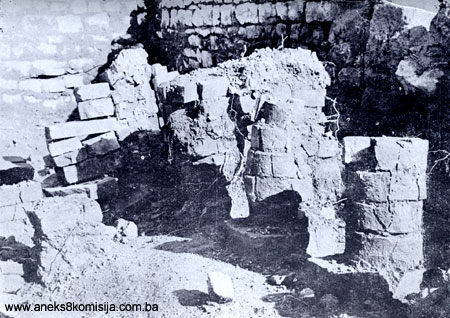
2. Description of the property
The camp extended over an area of about 1.5 hectares, and was built on a site that had not previously been inhabited. It was surrounded by stone ramparts 140 m long from north to south and 110 m long from east to west. The ramparts were about 0.9 m thick. All four corners of the perimeter ramparts have been excavated, but the disposition, shape and size of the towers and entrance remain unknown, since they have been cleared away. Here and there parts of the foundations of the ramparts, with a width of 0.90 to 0.95 m, have been excavated.
According to Bojanovski, there was a standing military camp (castra stativa) here, built for a cohort and its cavalry squadron of 30 cavalrymen. Each cohort had six centuries, and it may be assumed that a further five pavilions, i.e. sections of the barracks, similar to building III, remain to be found, of which two or three would be north of the central building and three or four to the south west of it on the part of the site that has not been excavated (Bojanovski, 1988, 366). The camp was designed for 400 to 500 soldiers. The area of the camp probably extended beyond the perimeter ramparts on all four sides almost as far as the roads that border the terrain on all sides (Bojanovski, 1980, 18).
Of the 1.5 hectares occupied by the camp within the ramparts, about 2500 sq.m. was excavated during the 1976-1979 campaigns, or about 1/6 of the walled-in area. Part of the terrain within the defence rampart – the entire western and southern areas – remains unexcavated. There are piles of stone here that have been cleared from the soil so the land could be used for cultivation (Bojanovski, 1980, 18 – 19).
The arrangement of early imperial Roman military camps, of which the camp in Gračine is one, was as follows. At the centre of the camp was the command building (principia). Beside this would be a temple as the centre of religious worship; this has not been found in Gračine. As well as lodgings for officers, there would also be huts for the soldiers, who were deployed into centuries and ales. There were also various auxiliary buildings within the camp, a clinic, stables, workshops and so on. There was usually a space left alongside the ramparts for chariots and troops to move about (ambulatorium). In Gračine this was probably in the south-east and north-west parts of the camp.
All the excavated parts of the camp were within the ramparts. The stone used in building was quarried very close to the camp from a site in Gračine.
In the area of the camp that was excavated, a complex of four buildings was uncovered, of which two, marked as buildings II and III, were wholly excavated and the other two, I and IV, were partly excavated, because they had been largely cleared away. The buildings lay north-east/south-west, and stood very close to or interconnected with one another. Buildings II and III were separated by a small courtyard with a width of from 4 to 10 m. Building I was just 5 metres away from building II, and building IV was also very close to buildings II and III, to the east of the two buildings and separated from them by a corridor about 3 m wide with a kind of vestibule serving both buildings.
Building I extends alongside the north-eastern part of the perimeter ramparts and probably occupied an outer position in the camp. Part of one room, measuring 12 x 9 m, was excavated. The walls are 0.6 m thick. Nothing definite can be ascertained concerning its architecture and the purpose for which it was used within the camp.
Building II was the central building in the camp, and stood some 5 m from building I. This is the best preserved of the buildings, albeit mainly in its foundations, which are as much as 1.5 m deep in the eastern, two-storeyed section, and has been wholly excavated. It was also the most solidly built structure, the eastern part of which had two levels (a basement with central heating and a ground floor), while the western part had just a ground floor level, built on shallower foundations, leading to the assumption that it was a later extension (Bojanovski, 1980, 29). In the eastern, higher section a large quantity of clamps for holding the ceiling in place were found. The building had an area of about 550 sq.m. The surviving foundation walls, which are 0.5 to 0.6 m. thick, were built of fairly regularly cut blocks laid in regular courses of two thick and one thin course.
This is the only building that had central heating equipment (praefurnium), in room A. From here pipes carried hot air to rooms B, C, F, G, I (a bathroom), in which hypocausts, suspensuras and tubulae were found in the basement area.
In the centre of the building are central rooms 9 m wide and of varying lengths ranging from 2 to 7 m (A to E). To the north of these (F to J) are a series of rooms, probably residential, of smaller size, about 5 m wide and also of varying lengths, from 4 to 7 m. To the south of the central rooms are the toilet facilities (P) and a space (N to M) that was probably a later addition facing building III, as a kind of verandah.
The best equipped and largest room was B, measuring 9 x 7.45 m. In the basement beneath this room 13 rows of suspensuras were noted, set 0.35 m apart. The suspensuras were covered by large bricks with a double coat of mortar over. The lower coat is 15 cm thick and made with coarse sand and the upper is 10 cm thick and made with fine sand. Mosaic is laid in this layer. Small fragments of the floor mosaic, which was made of black and white cubes in a geometric design, have survived alongside the walls. The walls of this room were decorated with frescoes, of which some small pieces were found with red, green and white paint. The adjacent, western room, C, measuring 9 x 5 m, had central heating. The basement below this room was linked to two apertures for room B. The remains of suspensuras were found here too. The floor and walls of this room were decorated in the same way as those of room B. To the west of these is room D, measuring 9 x 5 m, which is in the western, shallower part of this building. The floor was of small bricks laid in a herring-bone pattern. To the south and north of these are rooms P (toilet block) and I (bathroom) which, together with room C, probably formed part of an apartment (Bojanovski, 1980, 28-30).
The assumption is that this building housed the camp command, the so-called «central building». The archaeological material in this building is typologically and culturally limited to the period from the late first half of the first century to the second century CE (Bojanovski, 1988, 366).
Building III had much shallower and less solid foundations than building II. Most of the walls have been destroyed by deep ploughing. The foundations are of quarry stone, and in places a single course of the above-ground wall of cut blocks has survived.
This was a single storey building, with narrower walls than building II. The arrangement of the rooms is simple – a central corridor with small rooms leading off it. Many movable archaeological finds were discovered in this building, belonging to various military items in daily use. This leads to the conclusion that the building was used as a pavilion for the soldiers of one of the centuries.
Building IV, which has been almost wholly cleared away, was to the east of buildings II and III. All that remains is part of the corridor linking it to these two buildings. It is not possible to deduce anything about its arrangement or use, but it appears to have been an annex to the central structure, building II (Bojanovski, 1980, 21).
The camp underwent several stages of construction. Cohors III Alpinorum equitata, which was stationed in the camp in Gračine throughout the first century, left behind it no building inscriptions or stamps. To all appearances, however, it was during this time that most of the building works on the camp were carried out. In the second century it was replaced by Cohors I Belgarum, which left behind some written evidence of the construction of the camp.
The movable archaeological material, according to Bojanovski, belonged to the typical inventory of a Roman military camp: arms, equipment, various items of daily use, and bricks with the stamps of military units, LEG. III AVG and COH. I BELG, COH VIII VOLUNTARIORUM. In addition, the finds included shards of provincial terra sigillatae, glass drinking cups and bottles, and pottery lamps (lucerne), bronze applique and needles, and buttons. During the 1977-1979 excavations, 63 first-century Roman coins were found belonging to the Emperors Augustus, Tiberius, Caligula, Claudius and Nero (Kraljević, 1985, 134). Coins of later date that were found were a dinarius of Alexander Severus dated 224, and a follis Konstantiusa II of 337 (Bojanovski, 1980, Annex 2, Numismatic finds).
In his account of the excavations in Gračine, I. Bojanovski notes that even after conducting these archaeological works on the site, which were fairly limited in scope, there remains much that is unknown. The spatial arrangement of the camp could not be ascertained, and much of what is set out is assumption, taking it as read that this was a standing military camp (castra stativa). The layout of the camp has not been determined, although such camps from the early imperial period had an established basic layout (Bojanovski, 1980, 22-23). The existence of a camp in the Ljubuški region is not in dispute, as evidenced by the more than fifty tombstones of members of various military units in the environs of Ljubuški. The question is simply whether it was in Gračine, where the temple that was an obligatory component of a camp was not found and nor was an associated civilian settlement or canabae in the neighbourhood, given that the terrain has not been studied. On the other hand, nor is it in dispute that bricks were found in Gračine with the stamp of two cohorts, which is taken as evidence that the two cohorts in question were stationed there (Bojanovski, 1980, 25). In Hardomilje, on the right bank of the Trebižat, two inscriptions have been providing the information that in 173 coh. I Belg took part in the renovation and enlargement of the temple of Liber. Where this temple was, whether beneath the present-day monastery in Humac or on the right bank of the (Bojanovski, 1985, 68, n. 11; Dodig, 1985, 99), is not known. In his work on the finds from the right bank of the Trebižat, Dodig therefore gives a different opiniion, prompted among other things by the fact that Bojanovski, although a very reliable scholar, did not publish a complete account of the excavations in Gračine. Dodig expresses the view that building II in Gračine was a balneum (baths) with all the appropriate elements. He is of the view that building III was a casa with an atrium and vestibule. This leads inevitably to the conclusion that this was not a military camp but part of a civilian settlement or fortified villae, given that it is not in dispute that the site was surrounded by ramparts (Dodig, 1985, 96, n.4).
On nearby sites on the left and right banks of the Trebižat numerous tombstones and graves dating from the same period as the camp have been found, but the location of the necropolis associated with the camp itself remains unresolved (Dodig, 1985, 116).
3. Research and conservation and restoration works
Ÿ In 1976, when the Ljubuški-Vrgorac road was built, piles of stone were removed from Gračine to level the road. On this occasion, part of building II was discovered by chance. Fr Bonicije Rupčić led trial excavations on the site of the Roman military camp in Humac near Ljubuški. Several of the rooms in building II were excavated at that time. The movable archaeological material from this campaign is in the Archaeological Collection of the Franciscan monastery in Humac.
Ÿ In 1977-1989, as part of the scientific research project of the “archaeological excavations of the antique-era architecture of the military camp in Gračine near Ljubuški” an area of 2500 sq.m. was excavated, or approximately 1/6 of the area of the camp, without counting the perimeter ramparts and some possible smaller ancilllary buildings within the camp (Bojanovski, 1980, 18). The lead archaeologist was Dr. Ivo Bojanovski, of the Republic Institute for the Protection of Cultural Monuments and the Natural Heritage. The archaeological excavations were limited to the northern part of the camp, so that the full extent of the camp and all its contents, including those outside the ramparts, remains to be ascertained.
The movable archaeological material was mainly handed over to the National Museum in Sarajevo and the Museum of the Franciscan monastery in Humac, with a small quantity going to the Museum of Herzegovina in Mostar.
4. Current condition of the property:
An on-site inspection conducted in September 2003 ascertained the following:
Ÿ The site is at risk from rapid, intensive building in the immediate vicinity of the protected site of the antique-era excavations
Ÿ The site is exposed to specific threats (traffic, pollution, the effects of the elements)
Ÿ The site is at risk of rapid deterioration, and the conserved walls are collapsing in places, as the result of failure to provide regular maintenance
Ÿ The site of the excavations and around them is overgrown with bushes. There are piles of dug-out stone on the site around the excavations
Since the site is on plots on a level area surrounded on three sides by roads through the settlement and on the fourth by the large school building, access to the site is easy and display will also be easy. As a result, Protection Zone II covers the whole area on which there is a great deal of building presenting a threat to the monument.
III. CONCLUSION
Applying the Criteria for the adoption of a decision on proclaiming an item of property a national monument (Official Gazette of BiH nos. 33/02 and 15/03), the Commission has enacted the Decision cited above.
The Decision was based on the following criteria:
A. Time frame
B. Historical value
D. Clarity
D. iv. evidence of a particular type, style or regional manner
D. v. evidence of a typical way of life at a specific period
F. Townscape/ Landscape value
F.ii. meaning in the townscape
H. Rarity and representativity
H.i. unique or rare example of a certain type or style
The following documents form an integral part of this Decision:
- Photodocumentation;
- Drawings
Bibliography:
During the procedure to designate the monument as a national monument of Bosnia and Herzegovina the following works were consulted:
Atanacković-Salčić, Vukosava, Gračine, Humac, Ljubuški, antički vojni logor sa naseljem. (Gračine, Humac, Ljubuški, antique-era military camp and settlement) Archaeological Survey 19/1977, Federation of Archaeological Societies of Yugoslavia, Belgrade, 1977, 80-85, table, LII-LIV.
Atanacković-Salčić, Vukosava, Gračine, Humac, Ljubuški, antički - vojni logor sa naseljem. (Gračine, Humac, Ljubuški, antique-era military camp and settlement) Archaeological Survey 20/1978, Federation of Archaeological Societies of Yugoslavia, Belgrade, 1978, 73-77.
Bojanovski, Ivo, Arheološka istraživanja antičke arhitekture sa ostacima objekata vojnog logora i naselja i njegovog razvoja od i do V vijeka nove ere na lokalitetu Gračine kod Ljubuškog /1977-1979/. Naučno istraživački rad III. (Archaeological excavations of antique architecture with remains of buildings of military camp and settlement and its evolution from the 1st to 5th centuries CE in Gračine near Ljubuški, 1977-1979) Report. Institute for the Protection of Culture BiH, Sarajevo, Obala 27.jula 11a. Contract no: 03/4-249-1/77. Sarajevo, 1980.
Bojanovski, Ivo, Bosna i Hercegovina u antičko doba. (BiH in ancient times) Academy of Science and the Arts of Bosnia and Herzegovina, Works, Bk LXVI, Centre for Balkan Studies, Bk 6, Sarajevo 1988.
Bojanovski, Ivo, Epigrafski i topografski nalazi sa područja antičke Bigeste (pagus Scunasticus). (Epigraphic and topographic finds on the site of ancient Bigeste [pagus Scunasticus) In: 100 years of the Museum in Humac. Cultural Associatioin of Ljubuški Municipality, Ljubuški, 1985, 65-93.
Dodig, Radoslav, De Lubussa disputationes archaeologicae et epigraphice. In 100 years of the Museum in Humac. Cultural Association of Ljubuški Municipality, Ljubuški, 1985, 95-118.
Kraljević, Gojko, Numizmatička zbirka na Humcu (Numismatic collection in Humac) in 100 years of the Museum in Humac. Cultural Association of Ljubuški Municipality, Ljubuški, 1985, 133-138.
Pašalić, Esad, Antička naselja i komunikacije u Bosni i Hercegovini. (Antique-era settlements and roads in BiH) National Museum, Sarajevo, 1960.
Patsch, Carlo, Anhang - Die epigraphischen Denkmäler der römischen Strassen in Bosnien und der Herzegovina. In Balliif, Philip, Römische Srassen in Bosnien und der Herzegovina. Wien, 1893.
|