Status of monument -> National monument
Pursuant to Article V para. 4 Annex 8 of the General Framework Agreement for Peace in Bosnia and Herzegovina and Article 39 para. 1 of the Rules of Procedure of the Commission to Preserve National Monuments, at a session held on 4 to 8 March 2003 the Commission adopted a
D E C I S I O N
I
The site and remains of the Čaršija mosque in Prijedor are hereby designated as a National Monument of Bosnia and Herzegovina (hereinafter: the National Monument).
The site is located on a site designated as cadastral plot no. 1860, cadastral municipality Prijedor I, Prijedor Municipality, Republika Srpska, Bosnia and Herzegovina.
The National Monument consists of the site of the mosque, the harem or courtyard, and the burial ground alongside the mosque.
The provisions relating to protection and rehabilitation measures set forth by the Law on the Implementation of the Decisions of the Commission to Preserve National Monuments, established pursuant to Annex 8 of the General Framework Agreement for Peace in Bosnia and Herzegovina (Official Gazette of the Federation of BiH nos. 2/02 and 27/02/Republika Srpska no. 9/02) shall apply to the National Monument.
II
The Government of Republika Srpska shall be responsible for ensuring and providing the legal, scientific, technical, administrative and financial measures necessary to protect, conserve, display and rehabilitate the National Monument.
The Government of Republika Srpska shall be responsible for providing the resources needed to draw up and implement the necessary technical documentation for the rehabilitation of the National Monument.
The Commission to Preserve National Monuments of Bosnia and Herzegovina shall determine the technical requirements and secure the funds for preparing and setting up signboards with the basic data on the monument and the Decision to proclaim the property a National Monument.
III
The Government of Republika Srpska shall be responsible in particular for implementing the following measures:
- the Čaršija mosque in Prijedor and its surrounding mezarje (graveyard) shall be reconstructed in its original form, with the same dimensions (11.30 x 19.70 m), of the same materials or materials of the same kind, with the use of the same techniques and treatment as far as possible, on the basis of documentation on its original form, which forms an integral part of this Decision,
- the mosque shall be relocated to the north-west of its original site, as indicated on the site plan which forms an integral part of this Decision; the original site of the mosque shall be indicated on the ground in the mosque harem and pedestrian thoroughfare;
- the part of the cadastral plot on which the mosque formerly stood and which is now part of the pedestrian thoroughfare shall be indicated on the said pedestrian thoroughfare by distinctive paving; the layers of soil covering the part of the burial ground that has been turned into a pedestrian thoroughfare shall be removed; the burial ground shall be fenced/walled off following the boundaries of the site it occupied prior to 1992;
- all original fragments of the demolished building found on the site or on other sites to which they were removed after the demolition of the building, including tombstones removed to the Pećani dump, shall be recorded, conserved and reintegrated into the reconstructed building,
- all recovered fragments that are too badly damaged or for other justifiable reasons cannot be reintegrated shall be displayed appropriately within the mosque ensemble,
- prior to the start of reconstruction works, the surface layers of soil shall be removed in order to uncover the original foundation walls, which shall be surveyed in detail, made good as necessary, and marked on the ground on the pedestrian thoroughfare and mosque harem,
- all missing elements for which there is no reliable documentation shall be dealt with under the project in such a way as to ensure that their interpolation is plainly visible,
- all fragments of nišan that are recovered shall be presented in the parts of the site where mezars (graves) were located prior to demolition,
- since part of the architectural ensemble of the mosque harem has been turned into a pedestrian thoroughfare, the plot owned by the Islamic Community shall be supplemented by an area to the north or north-west of the mosque corresponding to the expropriated land,
- in the case of new buildings on adjacent plots, the minimum permissible distance from the new location of the mosque shall be 6m,
- new buildings on adjacent plots shall be of no more than two storeys (ground and one upper floor) of a maximum height to the roof cornice of 6m,
- no existing buildings on adjacent plots may be built onto nor increased in height.
IV
All executive and area development planning acts not in accordance with the provisions of this Decision are to be revoked.
V
Everyone, and in particular the competent authorities of Republika Srpska, and urban and municipal services, shall refrain from any action that might damage the National Monument or jeopardize the protection and rehabilitation thereof.
VI
The Government of Republika Srpska, the Ministry for Urban Planning, Housing and Public Utilities, Construction and the Environment of Republika Srpska, the relevant Protection Institute of Republika Srpska, and the Municipal Authorities in charge of urban planning and land registry affairs, shall be notified of this Decision in order to carry out the measures stipulated in Articles II to V of this Decision, and the Authorized Municipal Court shall be notified for the purposes of registration in the Land Register.
VII
The elucidation and accompanying documentation form an integral part of this Decision, which may be viewed by interested parties on the premises or by accessing the website of the Commission to Preserve National Monuments.
VIII
Pursuant to Art. V para 4 Annex 8 of the General Framework Agreement for Peace in Bosnia and Herzegovina, decisions of the Commission to Preserve National Monuments of Bosnia and Herzegovina are final.
IX
This Decision shall enter into force on the date of its adoption and shall be published in the Official Gazette of BiH and the Official Gazette of Republika Srpska.
This Decision has been adopted by the following members of the Commission to Preserve National Monuments: Zeynep Ahunbay, Amra Hadžimuhamedović, Dubravko Lovrenović, Ljiljana Ševo and Tina Wik.
No.: 07-6-145/03-3
5 March 2003
Sarajevo
Chairman of the Commission
Dubravko Lovrenović
E l u c i d a t i o n
I – INTRODUCTION
Pursuant to Article 2, paragraph 1 of the Law on the Implementation of the Decisions of the Commission to Preserve National Monuments, established pursuant to Annex 8 of the General Framework Agreement for Peace in Bosnia and Herzegovina, a “National Monument” is an item of public property proclaimed by the Commission to Preserve National Monuments (hereinafter referred to as the Commission) to be a National Monument pursuant to Articles V and VI of Annex 8 of the General Framework Agreement for Peace in Bosnia and Herzegovina and as property entered on the Provisional List of National Monuments of Bosnia and Herzegovina (Official Gazette of BiH no. 33/02) until the Commission reaches a final decision on its status, as to which there is no time limit and regardless of whether a petition for the property in question has been submitted or not.
The Commission received a petition from the Islamic Community of BiH Medžlis in 2002, and proceeded to carry out the procedure for reaching a final decision to designate the Property as a National Monument, pursuant to Article V of Annex 8 and Article 35 of the Rules of Procedure of the Commission to Preserve National Monuments.
II – PROCEDURE PRIOR TO DECISION
In the procedure preceding the adoption of a final decision to proclaim the property a national monument, the following documentation was inspected:
Ÿ Documentation on the location and current owner and user of the property (copy of cadastral plan and copy of land registry entry, Prijedor Municipality, dated )
Ÿ The current condition of the property
Ÿ Data on the current condition and use of the property, including a description and photographs
Ÿ Regulatory Plan for Prijedor Centre, 1987
Ÿ Regulator Plan for the central area of Prijedor with monument complex, 2000
Ÿ Historical, architectural and other documentary material on the property, as set out in the bibliography forming part of this Decision.
The findings based on the review of the above documentation are as follows:
1. Information on the historic monument
Location
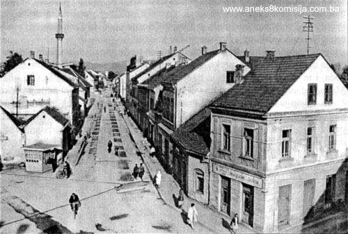
The Čaršija mosque is in Čaršija mahala in the centre of town, cadastral plot no. 1860, Prijedor I cadastral municipality, Prijedor, Republika Srpska.
The nucleus of the town was built on an island surrounded by the river Sana and Jendek (Berek-Žabljak). The town was founded at the time of the Viennese war (1683-1699), as a result of the Muslim population of Lika settling there. During the reign of Sultan Mahmud I (1730-1754) a fortress was built on the island. The varoš or town formed around the fortress. The island of Svinjarice (Stari Grad), a branch of the river Sana, Berek and the division into the island-based «Turkish varoš» and the shore-based «Serb varoš» lead us to traditions of the origins of Pridor, of Suhi Pridor or «dry Pridor» on the left bank and Mokri Pridor or «wet Pridor» on the right bank, of the root of the word «prodrijeti», to breach, and the river that altered its course near Hambarine. With time Pridor became Prijedor, with the mahalas of Grad, Zagrad, Ograde, Čaršija (around the bridge on the Berek), Majkovaca, Urije and Puharska (Prijedor i okolina, 1961, pp 8-11).
Historical data
A hadith qudsi in a chronogram over the entrance door gives the dates of 1840 and 1904 (“The places of worship in my land are my abode, and their visitors maintain them.” 1255 [1840] – 1322 [1904]) as the years in which the mosque was renovated, while in the harem of the mosque the oldest preserved nišan dates from 1832 (Mujezinović, 1998, p. 39).
The Čarsija mosque was set on fire on 30 May 1992 and then demolished, and its building materials were taken away to various sites outside the town. The site of the mosque was turned into a park.
2. Description of the monument
Architecture
The building, with exterior dimensions of 11.25 x 16.73 m, has two rows of windows, and consistent with the size of the building the stone walls are 105 cm thick. The exterior façade of the mosque was plaster rendered. The mosque had a hipped roof from which there arose a very slender wooden minaret, the top of which was about 26 metres above the ground floor level of the mosque. The roof structure was of wood, and the roof itself was of closely laid plain tiles with a double overlap. The ground plan and layout were the same as in the central mosque in Prijedor. There is a difference in ground plan between the two in that the Čaršija mosque had a somewhat less deep entrance area (2.70 m deep x 9.15 m wide) and a somewhat deeper “deep frontal” mahfil (gallery) (4.75 m deep x 9.15 m wide) than the central mosque, where the entrance area measures 5.00 m deep x 8.50 m wide and the deep frontal mahfil 4.00 m deep by 8.50 m wide.
The central prayer space was very spacious, with a width of 9.15 m and a length of 11.90 m. Certain information suggests that the prayer space was formerly even longer, but was shortened from the mihrab side in the course of street works (Bećirbegović, 1999, p. 129). The mahfil was reached from the entrance area via a three-flight wooden staircase to the left of the exterior entrance door.
The mahfil rested on two rows of wooden columns with corbels; no railed, raised sofas were constructed beneath the deep mahfil, at the level of the central space, so as to preserve the unity of the interior. The use of the deep mahfil together with the ground plan of the central area significantly increased the total usable area and the number of worshippers the mosque could hold at prayer time, which was the result of the specific political, economic and military circumstances in western Bosnia in the seventeenth and eighteenth centuries (Bećirbegović, 1999, pp. 58-63 and 127-129). The mahfil had an elliptical projection 80 cm deep and 240 cm wide in the axis of the mosque for the muezzin.
The minaret was reached from the mahfil by means of a wooden ladder. The total height of the minaret was 20 m (measured from the level of the wooden roof structure to the alem or finial topping the minaret). The minaret, in cross-section with fourteen equal sides, was 1.60 m wide at the base, 1.30 m wide at the gallery level, and 1.10 m wide near the top, below the cone. The central wooden mast was set in the axis of the right-hand front wooden pillar supporting the mahfil. The minaret was constructed of fourteen wooden perimetric pillars, chamfered on the exterior, their diameter gradually narrowing from the base of the minaret towards the top.
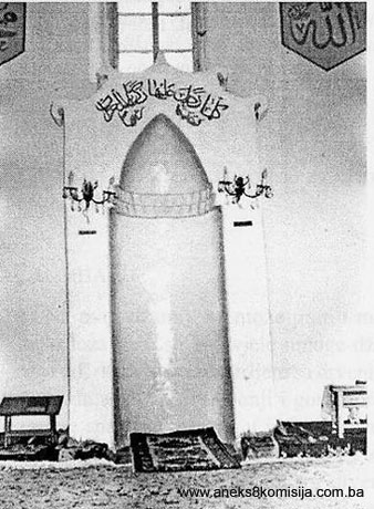
The interior contained mihrab, mimbar and ćurs (Ar. kursi, “throne”) as well as the mahfil. The mihrab, measuring 100 x 270 cm, was executed in the form of an elliptical niche topped by a pointed arch decorated with two horizontal bands of triangular motifs set on the pedestal of the arch; the mihrab niche measured 170 x 330 cm, and had a moulded finish in the upper part with unusual decoration.
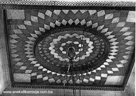
The ceiling was composed of wooden boarding about 20 cm wide, nailed on the lower side to the roof beams, with the joints between the boards covered with moulded latticing 3-4 cm wide, and moulded boards where the ceiling met the walls. In the centre of the ceiling of the Čaršija mosque was a square sofraluk edged in carved slats. The central circle within the rosette was decorated with coloured slats of rhomboidal form arranged in a geometric composition (Bećirbegović, 1999, pp. 58-63,129-130 and 167).
Typological links may be established in the Bosnian heritage between the Čaršija mosque in Prijedor, the central mosque in Prijedor and the Vidorija mosque in Bosanski Novi. Common to these mosques is that they have a single interior space with a large usable area for prayer, and that all three have a very slender wooden minaret emerging from the roof, all of them of the “open gallery” type, that is with the gallery of the šerefe (where the muezzin stands) unroofed.
The minarets are of wooden construction, with the same proportions as stone minarets. The ratio of the width of the minaret at the base to the total height from the base to the crescent moon is 1,60/21,50=1/13,5 in the case of the Vidorija mosque; 1,60/19,20=1/12 in the case of the town mosque in Prijedoru; 1,60/20,00=1/12,50 in the case of the Čaršija mosque in Prijedor; and 2,60/36,00=1/13,8 in the case of the Aladža mosque in Foča; these wooden minarets are of the same proportions as stone minarets.
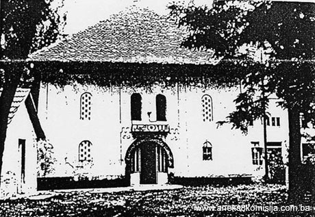
The windows in the façades are set in two rows. Each of the lower side façades has four windows, the mihrab wall has three in the upper and two in the lower row, and the entrance façade has four in the upper row (of which two have transoms) and two in the lower row, with the entrance door set in a round arch.
The central part of the entrance façade is emphasized by a shallow projection, with a decorative cornice at the level of the mahfil floor in the shape of a series of arches standing out from the background. The way in which the entrance area is emphasized, and the presence of horseshoe arches on the windows, indicate that the façade, and indeed the building itself, underwent certain alterations during the Austro-Hungarian period.
3. Current state of the monument
The Čarsija mosque was set on fire on 30 May 1992 and then demolished, and its building materials taken away to various sites outside the town. The site where it stood was turned into a park. Part of the mosque site was turned into a pedestrian thoroughfare as part of King Peter I the Liberator Street.
Inspection of the 2000 Regulatory Plan for the central area of Prijedor with monument complex revealed that provision had been made to relocate the mosque in order to widen the street (see Plan of Building and Regulatory Lines, Annex 5).
III – CONCLUSION
Applying the Criteria for the adoption of a decision on proclaiming an item of property a national monument, adopted at the fourth session of the Commission to Preserve National Monuments (3 to 9 September 2002), the Commission has enacted the Decision cited above.
The Decision is based on the following criteria.
A. Time frame
B. Historical value
C. Artistic and aesthetic value
C.iii. proportions
D. Clarity
D i. evidence of historical change
D. iv. evidence of a particular type, style or regional manner
E. Symbolic value
E. i. ontological value
E. ii. religious value
E. iii. traditional value
E. iv. connection with rituals or ceremonies
E. v. significance for the identity of a group of people.
F. Townscape/landscape value
F.ii. meaning in the townscape
G. Authenticity
G. v. position and location
G. vi. spirit and feeling
H. Rarity and representativity
H.i.unique or rare example of a certain type or style
The following documents, photographs and drawings form an integral part of this Decision:
1. Documentation of property rights
1.1. Čaršija mosque copy of cadastral plant
1.2. Čaršija mosque copy of land register entry
2. Photographs taken prior to the demolition of the building
3. Photographs taken since the demolition of the building
4. Architectural blueprints and technical drawings of the building – condition prior to demolition
4.1. Map of Bosnia and Herzegovina with position of the town marked
4.2. Plan of the town of Prijedor with the site of the building marked
4.3. Geodetic plan with building designated and indicating north
4.4. Ground plan at ground floor level
4.5. Cross section
4.6. Drawing of the mihrab
4.7. Drawing of windows
4.8. Drawing and outlines of minaret
4.9. Drawing and outlines of mihrab
5. Copies of entries in regulatory plans with accompanying documentation
Bibliography
Bećirbegović, Madžida, Džamije sa drvenom munarom u Bosni i Hercegovini, (Mosques with wooden minarets in Bosnia and Herzegovina), 2nd ed., Sarajevo-Publishing, Sarajevo, 1999
Mujezinović, Mehmed, ,Islamska epigrafika Bosne i Hercegovine, (Islamic Epigraphy of Bosnia and Herzegovina), Bk 3, 3rd ed., Cultural Heritage Editions, Sarajevo-Publishing, 1998
Prijedor i okolina (Prijedor and its surroundings), a publication of the National Committee of Prijedor Municipality and the press and publishing house Književne novine, Belgrade, Kultura, Belgrade, 1961 (using the services of the library of the Bosniac Institute in Sarajevo, founded by Adil Zulfikarpašić)
|