Status of monument -> National monument
Pursuant to Article V para. 4 Annex 8 of the General Framework Agreement for Peace in Bosnia and Herzegovina and Article 39 para. 1 of the Rules of Procedure of the Commission to Preserve National Monuments, at a session held from 25 to 31 January 2005 the Commission adopted a
D E C I S I O N
I
The architectural complex of the Old Vranduk Fort in Vranduk is hereby designated as a National Monument of Bosnia and Herzegovina (hereinafter: the National Monument).
The National Monument consists of the ramparts of the old fort with the keep and small tower, the mosque, and movable archaeological material excavated on the site and housed in the Museum of the City of Zenica.
The National Monument is located on a site designated as cadastral plot nos. 84, 85 and 123 (new survey), coresponding to c.p. nos. 191/47 and 191/48 (old survey), land register entry no. 468, cadastral municipality Vranduk, Municipality Zenica, Federation of Bosnia and Herzegovina, Bosnia and Herzegovina.
The provisions relating to protection measures set forth by the Law on the Implementation of the Decisions of the Commission to Preserve National Monuments, established pursuant to Annex 8 of the General Framework Agreement for Peace in Bosnia and Herzegovina (Official Gazette of the Federation of BiH nos. 2/02, 27/02 and 6/04) shall apply to the National Monument.
II
The Government of the Federation of Bosnia and Herzegovina (hereinafter: the Government of the Federation) shall be responsible for ensuring and providing the legal, scientific, technical, administrative and financial measures necessary to protect, conserve, and display the National Monument.
The Commission to Preserve National Monuments (hereinafter: the Commission) shall determine the technical requirements and secure the funds for preparing and setting up signboards with the basic data on the monument and the Decision to proclaim the property a National Monument.
III
To ensure the on-going protection of the National Monument, the following measures are hereby stipulated.
Protection Zone I consists of the area defined in Clause 1 para. 3 of this Decision. The following protection measures shall apply in this zone:
- all works are prohibited other than research and conservation and restoration works, including works designed to display the monument, with the approval of the Federal Ministry responsible for regional planning (hereinafter: the relevant ministry) and under the expert supervision of the heritage protection authority of the Federation of Bosnia and Herzegovina (hereinafter: the heritage protection authority),
- the site of the National Monument shall be open and accessible to the public, and may be used for educational and cultural purposes.
- the dumping of waste is prohibited
Protection Zone II consists of the area of the architectural ensemble of Vranduk, defined by the following boundaries:
- to the south, east and west, midstream of the river Bosna;
- to the north, the route of the M-17 road tunnel.
The following protection measures shall apply to this zone:
1. Carry out analysis of the current condition of the architectural ensemble of Vranduk, to include:
- chronological survey and style valorisation of existing residential properties,
- survey of number of storeys of existing properties,
- use of materials,
- state of damage and preservation,
- analysis of street fronts – detailed survey of the current condition, treatment, and identification of their complexity;
- analysis of open areas
2. Based on the analysis of the current condition, draw up a project for the restoration of the historical ambient of the architectural ensemble of Vranduk, with implementation of the following measures:
- maintenance, restoration, conservation and presentation of existing architectural structures and zoning elements of townscape value;
- restoration and reconstruction of the properties, forms and spaces that will enhance the ambiental value of the settlement;
- mandatory preservation or restoration of the original appearance of the properties (horizontal and vertical dimensions, proportions, number, size and arrangement of openings, architectural details and colours of walls, openings, treatment of facades),
- all methods used and levels of intervention must be recorded,
- cleaning and removal of extensions to properties or of entire properties themselves not appropriate to the townscape; replace individual elements on properties that have arisen as a result of subsequent interventions (replace gabled roofs by hipped roofs, remove balconies and loggias, remove picture windows/large glazed shop windows);
- no construction, artisanal-cum-construction or artisanal intervention shall be granted a building permit nor carried out without the approval of the relevant ministry and under the expert supervision of the heritage protection authority;
- no new use of any property shall be introduced contrary to traditional functions or use that would have the effect of altering the character and elements typical of the said townscape, or environmental polluting use.
3. Use of materials and forms on the properties:
- during conservation and restoration works, original materials shall be used (stone, tufa, schist), traditional binder media (hydraulic lime mortar, lime mortar) and traditional building methods, wherever possible;
- exterior surfaces shall be plastered with lime plaster and whitewashed;
- use of timber: pine, deal, juniper, chestnut, beech and oak;
- type and pitch of roof shall correspond to the original condition of the building: hipped roofs only, timber roof frames with pitch of 30 to 60 deg.;
- draw up a conservation and restoration project for side streets (sokak) with dry-stone retaining walls.
IV
The removal of the movable heritage items referred to in Clause 1 para. 2 of this Decision (hereinafter: the movable heritage) from Bosnia and Herzegovina is prohibited.
By way of exception to the provisions of paragraph 1 of this Clause, the temporary removal from Bosnia and Herzegovina of the movable heritage for the purposes of display or conservation shall be permitted if it is established that conservation works cannot be carried out in Bosnia and Herzegovina.
Permission for temporary removal under the conditions stipulated in the preceding paragraph shall be issued by the Commission to Preserve National Monuments, if it is determined beyond doubt that it will not jeopardize the movable heritage in any way.
In granting permission for the temporary removal of the movable heritage from Bosnia and Herzegovina, the Commission shall stipulate all the conditions under which the removal may take place, the date by which the items shall be returned to Bosnia and Herzegovina, and the responsibility of individual authorities and institutions for ensuring that these conditions are met, and shall notify the Government of the Federation of Bosnia and Herzegovina, the relevant security service, the customs authority of Bosnia and Herzegovina, and the general public accordingly.
V
All executive and area development planning acts not in accordance with the provisions of this Decision are hereby revoked.
VI
Everyone, and in particular the competent authorities of the Federation of Bosnia and Herzegovina, the Canton, and urban and municipal authorities, shall refrain from any action that might damage the National Monument or jeopardize the preservation thereof.
VII
The Government of the Federation, the Federal Ministry responsible for regional planning, the Federation heritage protection authority, and the Municipal Authorities in charge of urban planning and land registry affairs, shall be notified of this Decision in order to carry out the measures stipulated in Articles II to VI of this Decision, and the Authorized Municipal Court shall be notified for the purposes of registration in the Land Register.
VIII
The elucidation and accompanying documentation form an integral part of this Decision, which may be viewed by interested parties on the premises or by accessing the website of the Commission (http://www.aneks8komisija.com.ba)
IX
Pursuant to Art. V para 4 Annex 8 of the General Framework Agreement for Peace in Bosnia and Herzegovina, decisions of the Commission are final.
X
On the date of adoption of this Decision, the National Monument shall be deleted from the Provisional List of National Monuments of Bosnia and Herzegovina (Official Gazette of BiH no. 33/02, Official Gazette of Republika Srpska no. 79/02, Official Gazette of the Federation of BiH no. 59/02, and Official Gazette of Brčko District BiH no. 4/03), where it featured under serial no. 772.
XI
This Decision shall enter into force on the date of its adoption and shall be published in the Official Gazette of BiH.
This Decision has been adopted by the following members of the Commission: Zeynep Ahunbay, Amra Hadžimuhamedović, Dubravko Lovrenović, Ljiljana Ševo and Tina Wik.
No. 05.2-2-274/04-4
25 January 2005
Sarajevo
Chair of the Commission
Amra Hadžimuhamedović
E l u c i d a t i o n
I – INTRODUCTION
Pursuant to Article 2, paragraph 1 of the Law on the Implementation of the Decisions of the Commission to Preserve National Monuments, established pursuant to Annex 8 of the General Framework Agreement for Peace in Bosnia and Herzegovina, a “National Monument” is an item of public property proclaimed by the Commission to Preserve National Monuments to be a National Monument pursuant to Articles V and VI of Annex 8 of the General Framework Agreement for Peace in Bosnia and Herzegovina and property entered on the Provisional List of National Monuments of Bosnia and Herzegovina (Official Gazette of BiH no. 33/02) until the Commission reaches a final decision on its status, as to which there is no time limit and regardless of whether a petition for the property in question has been submitted or not.
The Commission to Preserve National Monuments issued a Decision to add the property to the Provisional List of National Monuments of Bosnia and Herzegovina, under the heading Vranduk mediaeval town and fortress, numbered as 772.
Pursuant to the provisions of the law, the Commission proceeded to carry out the procedure for reaching a final decision to designate the Property as a National Monument, pursuant to Article V of Annex 8 and Article 35 of the Rules of Procedure of the Commission to Preserve National Monuments.
II – PROCEDURE PRIOR TO DECISION
In the procedure preceding the adoption of a final decision to proclaim the property a national monument, the following documentation was inspected:
- Documentation on the location and current owner and user of the property (copy of cadastral plan and copy of land register entry)
- Details of legal protection of the property to date
- Data on the current condition and use of the property, including a description and photographs, data of war damage, data on restoration or other works on the property, etc.
- Historical, architectural and other documentary material on the property.
The findings based on the review of the above documentation and the condition of the site are as follows:
1. Details of the property
Location
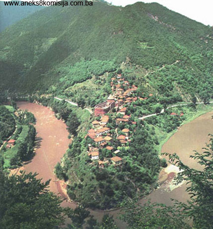
Vranduk and its old fort are situated on the left bank of the river Bosna, about 2 km to the north of Zenica, on the main M-17 Sarajevo-Zenica-Doboj road.
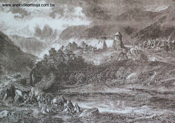
In its natural and geographical position, Vranduk guards the entrance to Central Bosnia, standing as it does at the very summit of a steep, inaccessible gorge. It is also the core from which this pictureque settlement developed. The fort is on a very important strategic route that ran along the Bosna valley from Visoko to the river Sava, which is 143 km from Vranduk. In addition to its strategic military value, the road was also of importance for merchants, particularly in the mediaeval and later periods. The defences of the passage from the central to the upper river Bosna valley had always been here.
The settlement is characterized by the specific relationship between the fortress and its outskirts (civilian settlement), which gives the entire image of Vranduk its particular value. The layout of Vranduk, with the fort at the centre and two separate residential quarters (Donja Mahala and Prigrad with Zavteza) resembles certain prehistoric hillfort-type settlements.
It consists of a site designated as cadastral plot nos. 84, 85 and 123 (new survey), coresponding to c.p. nos. 191/47 and 191/48 (old survey), land register entry no. 468, cadastral municipality Vranduk, Municipality Zenica, Federation of Bosnia and Herzegovina.
Historical information
Archaeological excavations to date on the actual site of the fort have yielded no signs of fortifications dating from the prehistoric period or antiquity (Raunig, 1973, 435). When it was conquered by the Illyrians in the early first century CE, the road ad Bathinum flumen was laid between the years 14 and 20, from Salona, part of which ran along the Bosna valley from Zenica towards Žepča. This was a military road, via munitia. No remains of a Roman road downstream from Zenica have been identified. To the north-east of Zenica is a mountain barrier about 1000 m high, not easily crossed, through which the river Bosna made its way to create the Vranduk pass, but it has not been proven whether it led via Orahovica (the route taken by Eugene of Savoy in 1697, avoiding Vranduk) (Bojanovski, 1973, 408, idem, 1974, 202; Kreševljaković, 1957, 211).
Vranduk was in the mediaeval župa (county) of Brod, one of seven counties of mediaeval Bosnia, which first features as a country in historical documents in the mid 10th century. From the 14th century to 1463, Vranduk was a gubernatorial town, and then a royal town, belonging to the Crown Lands. At this time it was the only fortified town in the county of Brod.
Historical works emphasize the military function of the fortress, and particularly the heightened concern of Bosnia’s kings in the 15th century on account of its important strategic position. Since Vranduk was not of immediate interest to Dubrovnik merchants and business people, no major economic activity is recorded in Dubrovnik’s administrative documents.
Archaeological and toponomastic evidence in Vranduk suggest that it underwent its full development in much the same way as the most advanced 15th century centres in Bosnia. In addition to the relatively small fortress, a system of defences took shape in the environs of Vranduk; within those walls, a small settlement “sotto Vranduch” also came into being. Its location on the slopes directly below the fort indicates the need for the protection of the fortified town. Here King Tomaš had the church of St Thomas built. There is no cultivable land alongside the fortress itself, as a result of which a larger trade and crafts settlement outside the ramparts came into being in the village of Varošišć, about 2.5 km. from the Vranduk fort. Here the Franciscans founded a monastery and built the church of St Mary, to which documents dating from 1449, 1461 and 1462 refer. Building began in 1447, but the church was still not finished in 1462 (Anđelić, 1972, 239; idem 1973a, 439, 448; idem 1984, 159, 252).
Being a royal fort, Vranduk was a major objective during campaigns by the Hungarian army against the Bosnian state. The earliest reference to it is in a letter from the Dubrovnik Government to Hungary’s King Sigismund dated 11 March 1410. The letter shows that the Croatian Slavonian ban (governor) Pavle Bősseny, commander of the Hungarian army, which was making incursions into central Bosnia via the river Bosna valley in battle against King Ostoja, was in Vranduk in March 1410 as castellan with a garrison of mercenaries of the Hungarian army. At the beginning of that same year the Hungarians had conquered Vranduk and seized it from Bosnia’s King Ostoja (Perojević, 1991. 432-434; Ćirković, 1964, 212; Anđelić, 1984, 144, 309).
The outskirts of Vranduk are referred to 20 years later, in 1430, when King Tvrtko II stayed there, “sotto Uranduch,” on 7 and16 August, as recorded by an envoy from Dubrovnik, Restić, who also reported to his government in a letter dated from the same place the following year, 1431(Jalimam, 1991, 29 notes 44, 45 and 46; Kovačević-Kojić, 1978, 82). During these years the pretender to the Bosnian throne, Radivoj, held Vranduk and received envoys from other states there (Jalimam, 1991, 29, note 48; 30, notes 53 and 54).
Under the command of the Croatian-Slavonian ban Matko Talovac, the Hungarians organized a military campaign, helping King Tvrtko II to regain the throne. They conquered the Ottoman army led by Isak-beg and restored a number of towns and forts to Tvrtko, including Vranduk (Jalimam, 1991, 30).
During King Tomaš’ reign, Vranduk was the object of particular attention. He was the king who had a church dedicated to St Thomas, his patron saint, below the fort; at his request, he obtained special privileges for it from the Pope in Rome. There is no reference to a Catholic church in Vranduk in early Ottoman official records (defters). Presumably the mosque dedicated to Sultan Mehmed II El Fatih was erected on it (Jalimam, 1991, 31; Handžić, 1973, 387). The sources also refer to this as the Imperial or Emperor’s mosque (Mujezinović, page 444). A berat (decree) issued by the Bosnan vali Silahdar Abdulah Pasha in Muharram 1195 AH (28 December 1780 to 26 January 1781) states that one Ali-halifa was appointed as imam and preacher (cami and hassa) of the Imperial mosque in Vranduk, in Brod nahija (Ottoman administrative district corresponding to a county). This document is held by the Imamović family in Vranduk. Some members of this family were imams in this mosque (Mujezinović, page 444).
After his wedding in Milodraž, King Tomaš was in Vranduk, from where he issued a charter to Duke Ivan Dragišić’s sons on 22 August 1446. The charter was countersigned by many other princes and landowners in addition to Stjepan Vukčić Kosača, indicating that they were staying in Vranduk with the king (Perojević, 1991, 513-514; Jalimam, 1991, 30-31). The king’s brother Radivoj, previously pretender to the throne, appears in documents from 1447 on as “Prince of Vranduk” (Perojević, 1991, 513; Jalimam, 1991, 29, note 46).
In 1449, King Tomaš entered into a reciprocal trade agreement with Prince Nikolo of Trogir, the terms of which included opening workshops in Split, Fojnica and Jajce (Kovačević- Kojić, 1987, 82).
While King Tomaš was with Hungary’s King Matthias Corvinus in Segedin in late 1458 and early 1459, when the situation in Serbia and Bosnia was discussed, a large Ottoman force commanded by Isak-beg, son of the late Ishak-beg, invaded Bosnia and laid siege to Bobovac and Vranduk in late January 1459. The Bosnian king informed King Matthias about this in a letter dated 10 February 1459, written in Jezero near Jajce and addressed to Ivan Vitez, Bishop of Varadin and adviser to Hungary’s King Matthias Corvinus (Perojević, 1991, 545-547; Ćirković, 1964, 318).
The curtain wall of the Vranduk fortress was probably reinforced during King Tomaš’ reign, when Bosnia was under increased pressure from the Ottomans. This refurbishment is associated with the end of the first half of the 15th century, when the king and his family often spent time in Vranduk.
Vranduk was conquered by the Ottomans in 1463 and from then on remained the northernmost frontier fortification under Ottoman rule. It was attached to the vilayet of the Crown Lands, a territorial unit of the Bosnian Sandžak.
According to a defter dating from 1468/9, Vranduk was the northernmost fort in Ottoman hands on the river Bosna. The Vranduk fort with its garrison and the “Podgrađe” varoš (outskirts, town) were in the Crown Lands vilayet. It is not referred to in the 1485 and 1498 censuses, but reappears again in a census dated 1516, as a fortress and centre of the Vranduk nahija. (Šabanović, 1982, 42, 125). Under the terms of a peace treaty between Sultan Bayezid II and Hungary’s King Ladislaw I in 1503, Vranduk was among the towns belonging to the Ottoman Empire (Šabanović, 1982, 55).
From 1516 to the end of the 16th century it was in the Vranduk nahija and had a garrison. Later it lost its strategic importance as the centre of this administrative unit, and remained as a fort in the Zenica region.
During his campaign against Bosnia in 1697, Eugene of Savoy, aware that Vranduk would be difficult to conquer, decided to bypass it (Kreševljaković, 1957, 211).
In the 18th century, 28 captaincies were established in the Bosnian Sandžak. Between the 1699 Treaty of Karlowitz and the 1718 Treaty of Passarowitz, but after 1715, the Vranduk captaincy was established, headquartered in Vranduk. It was only in 1773 that the headquarters of this captaincy was transferred to Derventa. During the 18th century Vranduk belonged to the Bosna Brod or Travnik kadiluk (area under the jurisdiction of a qadi or Islamic judge) in the Zenica nahija with Vranduk (Šabanović, 1982, 229; Kreševljaković, 1991, 29-30, 158-159, 161). As surviving documents reveal, in the 18th and early years of the 19th century, Vranduk was used as a prison for political prisoners, mainly educated people (Hrelja, 1957, 138).
A description dating from 1906 notes that the fort had four cannon (Jelavić, 1906, 314), the same number as in the 1833 inventory. Five years later, it was listed among the forts needing repairs (Kreševljaković, 1953, 20).
In 1878, Austrian troops occupied the fort without a battle. Until 1890 it was occupied by a small Austrian garrison. From then on it remained empty, and ceased to exist as a military strategic place.
2. Description of the property
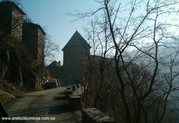
The old Vranduk fort is of the hill fortifications type. In terms of the area it covers, it is a small fort erected on a strategic, easily defended elevation which is difficult of access. The fort is well adapted to the lie of the land, resulting in considerably less thick rampart walls, and the smallest number possible of towers.
The layout of the defence structures and the size of the old Vranduk fort were dictated by the nature of the terrain. The fort was built on a natural and artificially levelled rocky stone plateau, and the curtain walls of the fort were erected on its slopes. It rises above the Bosna river valley by some 25 m. The fort lies with its long axis north-west. It consists of:
- ramparts and main entrance;
- bailey with cistern and well;
- main towers or keeps
- guardhouse (built onto the keep), and
- small towers.
The entrance to the fort is via a number of steps through a gateway in the north-east part of the bailey ramparts (C). The entrance is a simple, low-arched gateway, originally with no additional defence components. The entrance doorway is 0.82 m in height, and the overall height of the gateway is approx. 1.70 m. The door jambs are composed of sizeable pieces of quarry stone. Outside the entrance gateway is a paved plateau, to which the stone steps lead.
The main tower or keep of the fortress stands on the highest point of the old fort, to the north of the bailey. It was erected straight onto bedrock, the strata of which slope from north to south. It is partly set back into the curtain wall and part faces inwards.
The ground plan of the keep is roughly square, with the outer sides 9.25 in length and the inner approx. 5.85 x 5.80, with diagonal measurements of 6.50 m (south-north) and 7.50 m (east-west).
The tower was built of pieces of quarry stone with lime mortar binder; with the passage of time it has acquired a greyish patina. The walls vary in thickness. The north-west and north-east are the thickest, for strategic reasons, ranging in places from 1.95 m to as much as 2.20 m.
The upper reaches of the tower differ from the lower, with the thickest walls those facing the bailey to the north-west and south-east, while the north-east and north-west, where openings have been left, somewhat thinner, ranging from 1.10 m to 1.20 m in thickness. In the upper part of the tower, seen in section, the north, east and west corners are slightly rounded while the south corner of the walls meet at an angle of approx. 110 degrees. The keep was probably once taller, and was reduced in height when firearms came into use.
The entrance to the keep is in the south-west wall. Here the wall is 1.53 m thick. The door is 80 cm in width and about 2.20 m from the south corner of the keep.
The keep probably had three storeys, the lowest of which was used for storage purposes, and the upper two to house the garrison and for combat purposes.
The first floor is at a level of +3.31 m from zero level, the level of the bailey. This storey has two openings, facing north-west and north-east, which were later altered to form loopholes. The north-east opening is 1.60 m wide on the inside and 50 cm wide on the outside, with a height of 1.42 m on the outside and 1.17 m on the inside. The north-west opening is 1.60 m wide on the inside and 0.45 m on the outside, with a height of 1.48 m on the inside and 1.22 m on the outside. The window lintels are composed of 15 cm thick oak beams laid alongside each other.
The second storey includes a room for the garrison, with six trapezoid cannon holes in the north-east and north-west walls. These vary in width, ranging from 1.10 to 1.25 m at the base, with a height of approx. 80 cm on the inside, and from 48 to 61 cm on the outside. Later they were altered to form narrow loopholes. There is an access pathway along the entire length of these two walls, as a result of which the walls are more than 2 m thick in these places.
The floor joists of the keep were timber, and composed of a primary load-bearing beam in the form of a single, substantial oak beam set in special sockets in the south-west and north-east walls, with the secondary load-bearing structure laid across it. This consisted of oak joists, less substantial than the primary beam. Boards were probably attached to these joists. The roof of the keep is pyramidal, with eaves projecting beyond the wall face by 50 cm, and clad with cut wooden shingles.
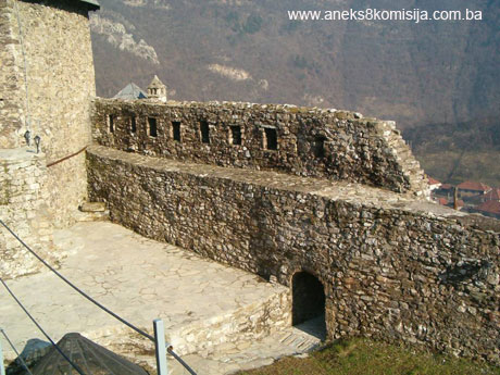
To the south of the keep lies the bailey, which is ellipsoid in ground plan, about 37 m in length and 12 m in width. The walls of the bailey were built in two stages. It is rare for separate walls to feature in fortifications architecture in Bosnia and Herzegovina. First come the outer ramparts, about 1 m in thickness, on the outer edge of the rocky plateau and incorporated into the cliff. When they were first built they lacked crenelations with loopholes at the top of the walls. Later, walls were built on the inside of the ramparts; these are up to 1.80 m thick, and of poorer quality, laid on a layer of very hard brown earth. These were used as the walkway of the ramparts. Twenty-seven loopholes were pierced, approx. 1.00 to 1.55 m apart, in the upper, outer part of the west rampart.
The rampart walls range in height from 4.50 to 7.50 m to the east, 9.50 to 12 m to the west, 9.50 to the north, and as much as 12.00 m to the south.
The cistern and filter well are in the north-west part of the bailey, cut into the bedrock to a depth of 6 m. The well-shaft sunk into the rock is 5.5 m in diameter. It was first faced with a 0.5 m thick layer of waterproof grey-green clay. This was followed by a 1.2 m thick layer of river gravel and sand. The central well-shaft is circular, with a diameter of 2.50 m, and is faced with carefully-laid cut tufa blocks of varying sizes. There was a low wall of quarry stone with mortar binder on the northern edge of the cistern. Part of this wall reached as far as the entrance to the fort. Judging from the type and solidity of its construction, this cistern was presumably built by Dalmatian masons (Raunig, 1973, 456-457).
A small tower was later built about 1.80 m from the north-east corner of the keep. This tower is an irregular rectangle in ground plan, with the west wall measuring 4.75 m on the outside, the east wall 5 m, the north wall 4.7 m ande the south wall 4.5 m. The walls vary in height from 5.35 to the west to as much as 8.30 m to the east.
The interior of the tower is also rectangular, 3.10 m in width to the east, 2.25 m to the north, 3.30 m to the west and 2.05 m to the south. It had a basement and two storeys.
The basement had no openings, and was at depth of 3.90 m below the level of the first storey.
The first storey had an entrance door 95 cm wide and a single window 75 cm wide to the east. The walls are approx. 1.15 m thick.
The second storey contains a room measuring 3.52 x 3.74 m. This room has five openings in all: to the south, 0.92 m wide and 0.95 m high; to the east, 0.81 m wide and 0.95 m high; to the north, two splayed loopholes, 15 cm wide on the outside and approx. 60 cm on the inside; and to the west, a single oblique loophole 1.05 m wide on the inside. There is a built-in fireplace with a paved hearth by the south wall. The fireplace is 84 cm wide. Smoke escaped through a chimney channel and stone chimney. The floor joists of the small tower were timber.
The wall of the tower is hipped, with 50 cm wide eaves, clad with wooden shingles.
A wall about 1.3 m thick and about 12.5 m long was built running parallel with the east rampart of the fort from the south-east corner of the small tower almost all the way to the entrance.
The entire system of the tower and separate wall was a later addition designed to protect the entrance to the fortress.
Archaeological remains
Archaeological works on the area of the bailey revealed a number of strata. At a depth of 2.10 to 1.66 m, on the rock forming the original ground-level of the building, burnt beams and the remains of burnt vegetation, small heaps of burnt soil and a pile of burnt grain were found in places. Three archaeological strata lay above the rock.
Cultural stratum 1 (Plan 1) was the lowest level, lying above the rock and over the remains described above. It ranged in thickness from 5 to 30 cm, depending on the uneven rocky soil. This is the floor level, composed of mortar with an admixture of light yellow sand. This flooring seems to have covered the entire bailey and to have been laid to level it. It was laid at the same time as the inner walls of the fortress were built or a little later (Raunig, 1973, 455).
The remains of the solidly built foundations of a crosswall built on the rock belong to the same stratum as the flooring. It ran from east to west, dividing the bailey into two unequal halves. It was built of cut quarry stone blocks, bonded with morter with quicklime. Some three metres from the west rampart was a door or entrance about 3 m wide. Part of a stone doorjamb found nearby probably belonged to this doorway.
There is a cistern with filter well in the north-west part of the bailey.
Cultural stratum 2 (plan 2) consisted of brown earth mixed with quarry stone and some minor finds. Less solidly-built buildings were found here.
The remains of a building made of wattle and daub ran south of building (B), below steps (E) on the west wall, reaching as far as the east rampart. This was probably used to store provisions. There was a hearth (no. 3) inside the building (Raunig, 1973, 457). Another two hearths made of tufa or burnt earth were found in an open area in the flooring of the bailey (nos. 4-6).
Close to hearth no. 6 in the southern half of the west wall, the remains of the substructure of a mill (no. 8) were found, built of quarry stone, with a substantial layer of what was probably burnt timber above it. Inside the substructure, two millstones were found at the bottom. The mill probably had stone footings with a manually-operated timber superstructure. More millstones or parts of millstones were found throughout the bailey in the same cultural stratum.
A bench was found by the east wall in the southern half of the bailey. The bench was 5 m long and about 1.4 m wide. It was built of quarry stone bonded with mortar. It is not known what it was used for.
The third excavated stratum (plan 3), the surface layer consisting of humusy soil and rubble, ranged in thickness from 0.2 to 0.5 m. Two lime pits (nos. 2 and 3) were found in this stratum, along with the remains of the Dizdar’s (fortress commander’s) house. The remains of the walls of a building made of šeper (1) were discovered at a 15 to 30 cm below surface level.
The substructure of this building was found below this stratum, at a depth of 0.3 to 0.5 m. It was composed of sizeable pieces of quarry stone laid on the ground in courses or compact surfaces. The house was probably already derelict when it accidentally caught fire. In the late 1960s, when the excavations were conducted, local people still knew that it had been the Dizdar’s house, but not when it burned down (Raunig, 1973, 458).
The buildings in stratum 1 belong to the period of the mediaeval Bosnian state, and those of strata 2 and 3 to the Ottoman period in Bosnia.
Movable artifacts
The most numerous artifacts are pottery shards. These are of typical late mediaeval pottery, where three basic types can be distinguished: coarse pottery in the shape of pots and dishes for everyday use, shards of finer-quality pottery vessels with traces of yellow-green and greenish-brown glaze or pigment, and fired pottery in the shape of drinking glasses.
The most common iron artifacts are sundry tools, harness parts (curb bits, horseshoes, spurs), arrows, door hinges and keys, and a few late mediaeval rings.
Part of an armoured doublet was found in the lowest stratum, stratum 1. The most common bronze artifacts are decorative pins, buckles and a few simple rings. The glass artifacts discovered were fragments of late mediaeval drinking cups. There were coins of various origin, Hungarian, Turkish and Yugoslav from the time of King Aleksandar, none of which has been chronologically identified.
Spurs of the same type were found in all three strata, along with pottery and coins from different periods, indicating that the strata had become intermixed. After preliminary treatment, the artifacts were handed over to the Museum of the City of Zenica, where they are kept in storerooms.
Despite later alterations, the fortress has retained its wholly original, simple form, reminiscent of earlier European fortifications. Although it is one of the few forts in Bosnia and Herzegovina that has been fully surveyed, it has not been possible to determine the exact date when it was built. Originally, in addition to the keep, there was a timber building for the garrison and a cistern (from the lowest cultural stratum 1) in a relatively cramped space between the bailey ramparts. This suggests that the fort was built in the late 14th century (Popović, 1995, 37).
In later times, the subsequent addition of the outer parts of the fortifications served as the front defence line. In the case of Vranduk this is the small tower with a wall separated by a wall and the thickened curtain walls of the bailey. These could have followed during the 15th century, prior to 1463.
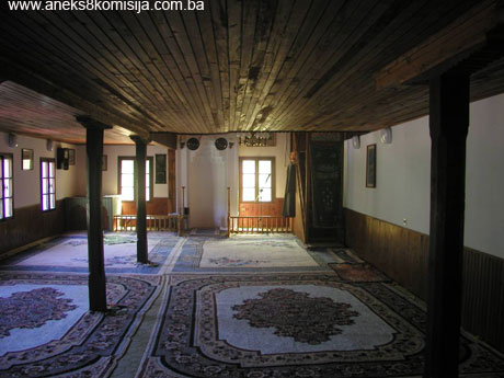
Sultan Fatih Mosque
Judging from old photographs taken before World War II, as well as others taken somewhat later, there were a great many buildings with steep hipped roofs clad with shingles on the slopes of Vranduk settlement. Among them was the old Vranduk mosque, known as the Sultan Fatih mosque. During later interventions, the pitch of the mosque roof was altered as was the roof cladding.
This mosque is of the type with a wooden double-sided mahfil and wooden minaret. It was built right beside the Vranduk fort(2).
The mosque is of rectangular ground plan, measuring 13.64 x 7.28 m, and consists of a ground and a first floor. Since it was built on a very steep site, the east wall, facing the river Bosna, is extremely high(3). One of the features of this mosque is its two entrances – one to the north and another to the west.
The north door, which is 1.63 m wide, leads into the ground floor of the mosque, or more exactly into an antechamber measuring 3.17 x 6.50 m, where the wooden staircase leading to the mahvil is located to the west. The main entrance to the central prayer space is roughly midway along the south wall, and is 1.34 m wide.
The west door leads straight into the mahfil(4), with no antechamber.
The interior of the central prayer area measures 14.10 x 6.54 m. The mosque lies north-south, not south-east/north-west.
There is a decorated mihrab by the south wall, with a niche with a diameter of 1.02 m and sides each 33 cm wide. The wooden mimber is in the south-west corner of the mosque.
The entire west wall and part of the north wall, over a length of approx. 2.20 m, are of quarry stone with lime mortar as binder medium. The stone wall here ranges in thickness from 55 to 64 cm. The rest of the ground floor wall and the entire first floor are half timbered, with an overall thickness of 14 cm.
In this mosque, the wooden mahfil covers two-thirds of the central prayer space. The side mahvil is 2.7 m wide and the front mahfil 9.1 m wide, so creating a large usable area. The height of the area above the mihrab is 3.7 x 4.60 m. The structure of the wooden mahfil rests on the west stone wall and a central wooden beam running north-south, with three wooden 14 x 14 cm pillars. The distance between the pillars varies from 2.50 m to the north to 5.87 m between the two pillars in the central part of the mosque.
To the east of the building are a total of twelve rectangular windows in two rows. The windows are 72.5 cm wide. To the south, in the mihrab wall, there are four windows, and in the north wall three – one lower and two upper. To the west,there are two windows beside the entrance door – one by the north-west and the other by the south-west corner of the building.
The mosque roof is hipped and, judging from the nature of the roof frame, the treatment of the timber components and the types of joints (steel cramps), this roof dates from one of many interventions, when the pitch of the roof was altered and the type of roof cladding changed. The mosque is now clad with plain tiles.
The mosque has an octagonal wooden minaret to which the outside of which thin vertical laths are fixed. To the north, about ten metres from the mosque, is a small abdesthana (premises for ritual ablutions before prayer), which is a later addition.
3. Legal status to date
By Ruling of the National Institute for the Protection of Cultural Monuments and Natural Rarities of NR BiH of Sarajevo, no. 1304/50, dated 9 October 1950, the property was placed under state protection, and by Ruling of the Institute for the Protection of Cultural Monuments of NR BiH of Sarajevo, no. 02-788-3 dated 18 April 1962, the old Vranduk fort, Municipality Zenica, in state ownership, c.p. nos 191/57 and 191/48, was placed under state protection and entered in the Register of Immovable Cultural Properties. This Ruling entered into force on 24 October 1962.
The 1980 Regional Plan for Bosnia and Herzegovina listed the property as a Category II cultural and historical property.
The property was on the Provisional List of the Commission to Preserve National Monuments under the heading Mediaeval town and fort of Vranduk, serial no. 772.
4. Research and conservation and restoration works
- 1914 – restoration work begun
- 1948 – the keep and small tower were roofed
- 1952 – conservation of the fortress walls was carried out – the demolished part of the wall on the keep was rebuilt (details from the file on the building of the Institute for the Protection of Monuments of BiH).
- 1959 – on account of damage caused by high winds, work was carried out to make good the shingle roof cladding. Cost of the work amounted to 38,000 dinars (details from the file on the property of the Institute for Protection of Monuments of BiH).
- 1967 – roof cladding on the towers was replaced
- June 1968 – archaeological excavations carried out (Branka Raunig MSc.). Following the excavations, the outer ramparts were made good.
- June and July 1968 – remains of the Franciscan church of St Mary in the village of Varošišać were surveyed. The works were supervised by Dr Pavao Anđelić.
- 1969 – conservation works on the fort were undertaken (all repair and conservation works were carried out by the Institute for the Protection of Cultural Monuments of BiH).
- 1998 – photographs were taken of the damage to the fort, and it was established that:
- the greatest damage was to the outside wall of the southwest part of the fort. This consisted of a visible vertical crack from the top of the rampart down to approx. 1.45 m above the rock on which the ramparts were built. The crack has caused a shift in the level of the wall face, in the form of a fissure of approx. 5 to 20 cm, narrowest at the bottom;
- there was considerable damage to the inner and outer wall surfaces, most of which was in the premises subsequently built during the Ottoman period, caused by pieces of stone falling as a result of the binder medium being washed out. It was not possible to determine the extent of the damage without excavations;
- parts of the east rampart had collapsed;
- there was extensive self-sown vegetation, which was undermining the structure of the walls;
- the roof cladding of the keep and the small tower was in very poor condition;
- the openings were unprotected;
- the walkway surface of the inner wall was damaged;
- the access to the fort was badly neglected.
- 1999 – the first stage of conservation and restoration work was carried out, as follows:
- clearing the old fort;
- removing and clearing grass and self-sown vegetation growing at various points on the inner and outer faces of the ramparts;
- clearing out the well;
- rebuilding the collapsed wall of the well-shaft;
- erecting a protective barrier around the well;
- installing a drainage channel;
- levelling the courtyard to provide a slope towards the drainage channel;
- making wooden windows and shutters for the small tower;
- making a wood door for the small tower;
- making a wooden door for the entrance to the fort;
- mounting iron bars on the entrance to the keep;
- repairing cracks on the east side of the ramparts using pieces of quarry stone and hydraulic mortar;
- making good damage to the crown of the rampart walls;
- making good damage to the walkway platform of the ramparts;
- constructing access steps to the fort;
- pointing the inner surfaces of the rampart walls.
- 2001/2002 – second stage of conservation and restoration works carried out, as follows:
- removal and clearing of self-sown vegetation from the inner and outer faces of the ramparts;
- dismantling the existing roof cladding of shingles on the keep and small tower;
- dismantling separate components of the timber roof structure from the keep and small tower and later reassembly;
- gradual clearing of the piled-up soil in the basement area of the keep to a level of 2.50 m (a depth of up to 30 cm in relation to the existing floor level in the basement) in order to lay quarry stone paving with a base layer;
- removal of a layer of soil to lay quarry stone paving in part of the bailey and outside the small tower. A 20 cm thick layer was removed;
- laying new paving of 5cm thick split paving stones on part of the area within the bailey (courtyard) of the fort and outside the fort on the small “plateau” outside the small tower, along the outer east ramparts, creating a slope of 1.5% to the south (towards the drainage channel carrying rainwater to the well); (5)
- laying new stone paving slabs;
- laying floors in the basement premises of the keep and small tower;
- laying quarry stone floors in the premises below the steps by the keep;
- pointing the walls after cleaning the joints by removing mortar, decomposed materials, grass and soil. The joints were cleaned using pressure water jets. Once dry, they were filled with 1:3 lime mortar;
- a single-faced wall on the south-west and west sections of the ramparts was built, as on the east and north-east footings of the ramparts by the small tower, using new quarry limestone in lime mortar, the composition of which matched that of the existing lime mortar in the surviving walls. The new stone was from the quarry where the stone was extracted for the previous conservation and restoration works on the fort. The size, finish, geometry and, in particular, the bond of the stone blocks correspond in full to the surviving wall surfaces;
- minor cracks and damage to the walls of the ramparts and towers, the wall by the small tower, and the vaulted passageway leading into the fort, were made good;
- parts of the timber pyramidal roof frame over the rectangular ground-plans of the keep and small tower were made and installed;
- roof battens (battens + laths) for the shingle cladding were installed;
- the roofs of the keep and small tower were double-clad with completely new shingle;
- timber floor joists for the basement/ground floor were made and mounted; (6)
- timber floor joists for the ground floor/first floor were made and mounted;
- a single-flight wooden stairway of cut oak for the entrance to the small tower was made and installed;
- single-casement windows were procured and mounted;
- a protective barrier on the access path to the fort and along the inner edge of the walkway of the outer ramparts was manufactured and erected; (7)
- the roofs above the keep and small tower were provided with thermo- and hydroinsulation;
- damaged parts of the stone door and window frames and minor damage to the structure of the walls were made good;
- the soil was consolidated by the east part of the fort using deciduous tree species the roots of which stabilize the soil;
- waste material was removed after the fort was cleared;
- a lightning conductor was made and mounted.
5. Current condition of the property
Since conservation and restoration works on the old Vranduk fort have been carried out on a numbeer of occasions by the Institute for the Protection of the Cultural, Historical and Natural Heritage of Bosnia and Herzegovina and the City of Zenica Museum, which initiated archaeological excavations on the fortress in 1968, it the fort can now be said to be in relatively good condition. In 1999, works began to implement the project to repair the fort – the first stage, in which urgent repairs to the ramparts, the small tower and the keep were carried out. The conservation and restoration works carried out in 2002 eliminated all the risks to which the fort was exposed. At the same time, the damage to the east side of the outer rampart which had been made good was monitored.
To the south of the fort, a stable and WC have been added to the residential property on c.p. no. 86, which poses a direct risk to the south rampart wall and to the fort as a whole. To the north of this building a large quantity of waste material has been dumped.
The mosque is in good structural condition. Apart from damp, there are no problems, particularly none of a structural nature. As a result of numerous interventions, particularly to the interior, the mosque has lost much of its authenticity. This pertains in particular to the inappropriate use of wooden panelling, which has been fixed to almost every surface – the ceilings, floor joists, stairs, and even the walls to a height of 80 cm – and to the exterior, where the roof pitch has been altered and unsuitable material used as cladding.
There are many properties in the settlement at risk of rapid deterioration because of the type of materials they were built from, and from lack of maintenance. Many owners have died and a number are living abroad. There is also the problem of the demolition of old properties and the erection of new ones that are inappropriate to the existing townscape in type and pitch of roof and in size. It is interesting to note that despite the use of modern materials as infill (brick, slag bricks), the original half-timbered system has been retained or used again.
The Vranduk fort is actively involved in every cultural event in Zenica and in Bosnia and Herzegovina (European Heritage Days, Plum Days, cultural events as part of the ZEPS fair, theatre performances . . .)
As part of the improvements to the tourist attractions of the city and the canton, the Tourist Association has incorporated the site into its programme.
Work is currently in hand to equip the exhibition display in the keep.
III – CONCLUSION
Applying the Criteria for the adoption of a decision on proclaiming an item of property a national monument (Official Gazette of BiH nos. 33/02 and 15/03), the Commission has enacted the Decision cited above.
The Decision was based on the following criteria:
A. Time frame
B. Historical value
C. Artistic and aesthetic value
C.iii. proportions
C.iv. composition
D. Clarity (documentary, scientific and educational value)
D.i. material evidence of a lesser known historical era
D.ii. evidence of historical change
D. iv. evidence of a particular type, style or regional manner
E. Symbolic value
E.iii. traditional value
E.v. significance for the identity of a group of people
F. Townscape/ Landscape value
F.ii. meaning in the townscape
F.iii. the building or group of buildings is part of a group or site
G. Authenticity
G.iv. traditions and techniques
G.v. location and setting
H. Rarity and representativity
H.i. unique or rare example of a certain type or style
H.ii. outstanding work of art or architecture
I. Completeness
I.iii. completeness
I.iv. undamaged condition
The following documents form an integral part of this Decision:
o Copy of cadastral plan
o Copy of land register entry and proof of title;
o Photodocumentation;
o Drawings
Bibliography
During the procedure to designate the monument as a national monument of Bosnia and Herzegovina the following works were consulted:
1904. Truhelka, Ćiro, Naši gradovi, opis najljepših sredovječnih gradova Bosne i Hercegovine (Our Towns, Description of the Most Beautiful Old Towns of Bosnia and Herzegovina). Sarajevo, Naklada Knjižare J. Studnička and others. 1904.
1906. Jelavić, Vjekoslav, Francuska izvješća o Bosni (French Reports on Bosnia), Jnl of the National Museum of Bosnia and Herzegovina, XVIII, Sarajevo, 1906, 307-314.
1908. Bodenstein, Gustav, Povijest naselja u Posavini 1718-1739 (History of Posavina Settlements 1718-1739), Jnl of the National Museum of Bosnia and Herzegovina, XX, Sarajevo, 1908, 95-112
1952. Kreševljaković, Hamdija, Prilozi povijesti bosanskih gradova pod turskom upravom. Prilozi za orijentalnu filologiju i istoriju jugoslovenskih naroda pod turskom vladavinom (Contributions to the History of Bosnian Towns under Turkish Administration, Contributions for Oriental Philology and the History of the South Slavs under Turkish Governance), II/1951, Institute for Oriental Studies in Sarajevo, Sarajevo, 1952,119-184.
1953. Kreševljaković, Hamdija, Stari bosanski gradovi. (Old Bosnian Forts) Naše starine I, Sarajevo, 1953, 7-45.
1957. Vego, Marko, Naselja srednjovjekovne bosanske države (Settlements of the mediaeval Bosnian state) Sarajevo, 1957.
1957. Hrelja, Kemal, Zenica i njena okolina (Zenica and its environs), Sarajevo, 1957.
1963. Anđelić, Pavao, Trgovište, varoš i grad u srednjovjekovnoj Bosni-Prilog tipologiji naselja (Market, town and fort in mediaeval Bosnia – contribution to the typology of settlements), Jnl of the National Museum of Bosnia and Herzegovina (Archaeology), n.s. vol. XVIII, Sarajevo, 1963, 179-194.
1972. Anđelić, Pavao, Bobovac i Kraljeva Sutjeska, stolna mjesta bosanskih vladara u XIV i XV stoljeću (Bobovac and Kraljeva Sutjeska, Headquarters of Bosnian Rulers in the 14th and 15th century), IRO Veselin Masleša, Sarajevo, 1972.
1973. Anđelić, Pavao, Pogled na franjevačko graditeljstvo XIV i XV vijeka u Bosni (Review of Franciscan Architecture of the 14th and 15th centuries in Bosnia) In Papers from Symposium «Mediaeval Bosnia and European Culture», Proceedings III, publ. Museum of the City of Zenica, Zenica, 1973, 201-206.
1973a Anđelić, Pavao, Ruševine srednjovjekovne crkve u Varošišću kod Vranduka (Ruins of a Mediaeval Church in Varošić near Vranduk) In Papers from Symposium «Mediaeval Bosnia and European Culture», Proceedings III, publ. Museum of the City of Zenica, Zenica, 1973, 439-452.
1973. Bojanovski, Ivo, Rimska cesta dolinom Bosne (Roman Road along river Bosna), In Papers from Symposium «Mediaeval Bosnia and European Culture», Proceedings III, publ. Museum of the City of Zenica, Zenica, 1973, 393-414.
1973. Handžić, Adem, Nahija Brod krajem XV i početkom XVI vijeka (Brod nahija in the late 15th and early 16th century), In Papers from Symposium «Mediaeval Bosnia and European Culture», Proceedings III, publ. Museum of the City of Zenica, Zenica, 1973, 383-381.
1973. Raunig, Branka, Osnovni izvještaj o iskopavanju srednjovjekovne utvrde Vranduk 1968. godine (Initial Report on Excavations of the Mediaeval Vranduk Fort 1968) In Papers from Symposium «Mediaeval Bosnia and European Culture», Proceedings III, publ. Museum of the City of Zenica, Zenica, 1973, 453-469
1974. Bojanovski, Ivo, Dolabelin sistem cesta u rimskoj provinciji Dalmaciji.(Dolabella's roads system in the Roman province of Dalmatia) Academy of science and the arts of Bosnia and Herzegovina, Proceedings, bk. XLVII, Centre for Balkan Studies, bk 2, Sarajevo, 1974.
1978. Kovačević-Kojić, Desanka, Gradska naselja srednjovjekovne bosanske države. (Urban Settlements of the Mediaeval Bosnian State) Sarajevo, 1978.
1979. Çelebi, Evliya, Putopis – odlomci o jugoslovenskim zemljama (Travelogue – Excerpts on Yugoslav countries), IRO Veselin Masleša, Sarajevo, 1979.
1982. Šabanović, Hazim, Bosanski pašaluk (The Bosnian pashaluk) Sarajevo, 1982.
1984. Anđelić, Pavao, Srednji vijek – doba stare bosanske države. (The Mediaeval Period – the time of the old Bosnian State) in: Visoko i okolina kroz historiju 1. (Visoko and environs through History 1). Municipality Visoko, Visoko, 1984,103-309.
1990. Jalimam, A. Salih, Vranduk kroz istoriju, prilozi za studiju (Vranduk through History, contributions to a study), Museum of the City of Zenica, Zenica, 1990.
1991. Kreševljaković, Hamdija, Kapetanije u Bosni i Hercegovini (Captaincies in BiH) Collected Works I, IRO Veselin Masleša, Sarajevo, 1991.
1991. Perojević, Marko, Stjepan Ostoja (opet) (Stjepan Ostoja [again]) In: Povijest Bosne i Hercegovine (History of Bosnia and Herzegovina), Bk.I, HKD Napredak, Sarajevo, 1942-1991. 427-451.
1991. Perojević, Marko, Stjepan Tomašević. In: Povijest Bosne i Hercegovine (History of Bosnia and Herzegovina), Bk.I, HKD Napredak, Sarajevo, 1942-1991., 505-554.
1995. Popović, Marko, Srednjovekovne tvrđave u Bosni i Hercegovini (Mediaeval Forts in Bosnia and Herzegovina). Zbornik za istoriju Bosne i Hercegovine 1 (History of Bosnia and Herzegovina Collected Papers 1), Serbian Academy of Sciences and Arts, Committee for History of Bosnia and Herzegovina, Beograd, 1995, 33-55.
1998 Mujezinović, Mehmed, Islamska epigrafika Bosne i Hercegovine (Islamic epigraphics of BiH), bk. II, 3rd ed., Cultural Heritage Series, Sarajevo Publishing, 1998.
1999. Bećirbegović, Madžida, Džamije sa drvenom munarom u Bosni i Hercegovini (Mosques with wooden minarets in BiH), Sarajevo Publishing, 1999.
(1) burnt red household lime with traces of wattle
(2) According to Madžida Bećirbegović, fort mosques had various positions. In most instances they were in the central part of the fort, which was the best protected, as can be seen in the cases of the mosques in Bužim, Jezersko, Kušlat, Peć, Ostrožac, Stijena etc. Sometimes it would stand immediately above the gate house, like the mosques in Ostrožac, Podzvizd etc. In Velika Kladuša it was located inside the fort, while the one in Vranduk was built outside the ramparts, but very close to the tower. Such mosques had a well located within the fort instead of a fountain (Bećirbegović, page. 28).
(3) The height of this wall is equivalent to the height of a three or even four storey building
(4) For this reason it was presumably used soley by women.
(5) Before laying the paving slabs, the soil was levelled and tamped and a layer of drainage gravel was laid over it of 10 mm granulation in a layer d=20 cm, creating a slope of 1.5% towards the drainage channel. A small channel was laid in the layer of gravel. A layer of sand, 5 cm thick, was laid on the gravel surface, and the new paving stones were bedded in the sand. The joints were pointed with cement mortar.
(6) The construction consists of the following elements: main transverse load-bearing beam, which supports wooden beams. Boards were nailed to the beam as the flooring base. Hard felt was laid on the beams under the floorboards to reduce impact. Fibreglass insulation was laid between the beams.
(7) The girders of the barrier consist of solid iron 2.0 x 2,0 cm sections, anchored to the stone structure of the wall and floor. These are interconnected with three rows of wire cables fitted with tensioning bolts to enable them to be tightened as needed. The barrier is of transparent type.
|