Status of monument -> National monument
Pursuant to Article V para. 4 Annex 8 of the General Framework Agreement for Peace in Bosnia and Herzegovina and Article 39 para. 1 of the Rules of Procedure of the Commission to Preserve National Monuments, at a session held from 6 to 12 May the Commission adopted a
D E C I S I O N
I
The archaeological site of Ripač in the village of Ripač near Bihać is hereby designated as a national monument of Bosnia and Herzegovina (hereinafter: the National Monument).
The National Monument stands on Velika otoka comprising cadastral plots 1417, 1418, 1406-1407, 1411-1414, 1416, 1420-1428; Mala otoka comprising c.p. 1399,1400 1398, 1402-1405; and Gradina on the right bank of the Una, comprising c.p. 1352-1355, 1357, 1358, 1382, 1382/2, 1391, 1395,1396, Bihać Municipality, Federation of Bosnia and Herzegovina, Bosnia and Herzegovina.
The provisions relating to protection and rehabilitation measures set forth by the Law on the Implementation of the Decisions of the Commission to Preserve National Monuments, established pursuant to Annex 8 of the General Framework Agreement for Peace in Bosnia and Herzegovina (Official Gazette of the Federation of BiH nos. 2/02 and 27/02) shall apply to the National Monument.
II
The Government of the Federation of Bosnia and Herzegovina (hereinafter: the Government of the Federation) shall be responsible for ensuring and providing the legal, scientific, technical, administrative and financial measures necessary to protect, conserve, display and rehabilitate the National Monument.
The Government of the Federation shall be responsible for providing the resources for drawing up and implementing the necessary technical documentation for the rehabilitation of the National Monument.
The Commission to Preserve National Monuments of Bosnia and Herzegovina (hereinafter: the Commission) shall determine the technical requirements and secure the funds for preparing and setting up signboards with the basic data on the monument and the Decision to proclaim the property a National Monument.
III
For the purpose of preservation of the National Monument the following Protection Zones are hereby designated:
Protection Zone on Velika otoka comprises c.p. 1406-1407, 1409-1414/1,2,3, 1420-1428 On Velika otoka plots 1417, 1418 have been partly surveyed. The other plots - 1406-1407, 1411-1414, 1416, 1420-1428 – have not been surveyed. Plots c.p. 1407 and1408 (mosque and graveyard) and 1422/1,2,3 are owned by the Islamic Community; the remainder are in private ownership.
On Mala otoka the protection zone covers the entire area, c.p. 1398, 1402-1405. On Mala otoka plots 1399 and 1400 have been partly surveyed in the strip along the west bank. The other plots – 1398, 1402-1405 – have not been surveyed. All are in private ownership.
The protection zone on Gradina comprises c.p. 1352-1355, 1357, 1358, 1382, 1382/2, 1391, 1395,1396, all in private ownership. A very small area of Gradina has been surveyed in the south-east part of the site north of the mosque and graveyard.
Systematic archaeological investigations should be carried out on the entire protected area.
The construction of new buildings or any other works that could have the effect of damaging or disturbing the archaeological stratum or altering the appearance of the National Monument are prohibited without a prior on site inspection by a qualified architect and approval from the Federal minister responsible for regional planning and the professional supervision of the heritage protection authority of the Federation of Bosnia and Herzegovina.
IV
All executive and area development planning acts not in accordance with the provisions of this Decision are to be revoked.
V
Everyone, and in particular the competent authorities of the Federation of Bosnia and Herzegovina, the Canton, and urban and municipal authorities, shall refrain from any action that might damage the National Monument specified in Clause I of this Decision or jeopardize the preservation and rehabilitation thereof.
VI
The Government of the Federation, the Federal Ministry responsible for town planning, the Federation heritage protection authority, and the Municipal Authorities in charge of urban planning and land registry affairs, shall be notified of this Decision in order to carry out the measures stipulated in Articles II and IV of this Decision, and the Authorized Municipal Court shall be notified for the purposes of registration in the Land Register.
VII
The elucidation and accompanying documentation form an integral part of this Decision, which may be viewed by interested parties on the premises or by accessing the website of the Commission (http://www.anek8komisija.com.ba)
VIII
Pursuant to Art. V para 4 Annex 8 of the General Framework Agreement for Peace in Bosnia and Herzegovina, decisions of the Commission are final.
IX
This Decision shall enter into force on the date of its adoption and shall be published in the Official Gazette of BiH and the Official Gazette of the Federation of BiH.
This Decision has been adopted by the following members of the Commission: Zeynep Ahunbay, Amra Hadžimuhamedović, Dubravko Lovrenović, Ljiljana Ševo and Tina Wik.
Chairman of the Commission
Amra Hadžimuhamedović
No: 06-6-541/03-9
6 -12 May 2003
Sarajevo
E l u c i d a t i o n
I – INTRODUCTION
Pursuant to Article 2, paragraph 1 of the Law on the Implementation of the Decisions of the Commission to Preserve National Monuments, established pursuant to Annex 8 of the General Framework Agreement for Peace in Bosnia and Herzegovina, a “National Monument” is an item of public property proclaimed by the Commission to Preserve National Monuments (hereinafter referred to as the Commission) to be a National Monument pursuant to Articles V and VI of Annex 8 of the General Framework Agreement for Peace in Bosnia and Herzegovina (hereinafter referred to as Annex 8) and as property entered on the Provisional List of National Monuments of Bosnia and Herzegovina (Official Gazette of BiH no. 33/02) until the Commission reaches a final decision on its status, as to which there is no time limit and regardless of whether a petition for the property in question has been submitted or not.
At a session held on 1-2 July 1999 the Commission issued a Decision to add the archaeological site of Ripač in the village of Ripač nr Bihać to the Provisional List of National Monuments of Bosnia and Herzegovina, numbered as 62.
Pursuant to the provisions of the law, the Commission proceeded to carry out the procedure for reaching a final decision to designate the Property as a National Monument, pursuant to Article V of Annex 8 and Article 35 of the Rules of Procedure of the Commission to Preserve National Monuments.
II – PROCEDURE PRIOR TO DECISION
In the procedure preceding the adoption of a final decision to proclaim the property a national monument, the following documentation was inspected:
Ÿ Documentation on the location and current owner and user of the property (copy of cadastral plan and copy of land registry entry)
Ÿ Data on the current condition and use of the property, including a description and photographs, data of war damage if any, data on restoration or other works on the property if any, etc.
Ÿ Historical, architectural and other documentary material on the property, as set out in the bibliography forming part of this Decision.
The findings based on the review of the above documentation and the condition of the site are as follows:
1. Details of the site
Location
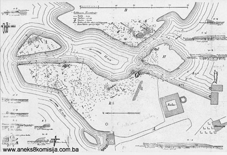
Ripač is in the south eastern part of the Bihać plain, at the point where the Una enters a gorge some 9 km south of Bihać. The present-day settle extends along both banks of the Un and on the island eyots of Velika and Mala otoka.
Some 250 m away, immediately above Velika and Mala otoka, on the right bank of the Una, is the site of Gradina.
Historical data
Three necropolises have been discovered in Bihać plain: Jezerine in Pritoka, in Ribić and in Crkvina in Golubić, with archaeological finds typical of the material culture of the prehistoric tribe of the Japodi (from the tenth century BCE to the second century CE).
There are no historical data for the prehistoric and antique part of the site. The lake-dwelling settlement on Velika and Mala otoka has been dated by archaeological means to the period of the late Bronze Age and early Iron Age, from the tenth to the end of the fourth century BCE.
Finds of items from antique times, including six Roman coins dating from the second to the fourth century, scattered about Velika otoka, and parts of a wall dating from antiquity, indicate that there was at least one building on the island at that time.
There is a square building, a tower or keep, on Velika otoka, probably the remains of the mediaeval fortress of Ripač which is known from fifteenth century historical sources. References to this fortress date from 1408 onwards.
In 1408 King Sigismund issued a charter to Toma Tompa which draws attention to his services in defending Ripač from the Bosnians and Ottomans. At that time, Ripač was an important place in the Hum župa or county.
In 1431 and 1434 King Sigismund bestowed and affirmed the fort of Ripač to the princes of Krk Frankopan.
Prior to 1449 the fort of Ripač was in the possession of the Krbava princes.
In 1512 there is reference to a military garrison in Ripač from then until 1587 the names of several castellans are known.
In 1527 Nikola Jurišić took Ripač for King Ferdinand and reaffirmed all the old privileges of the inhabitants.
In 1591 the Ottomans seized Ripač after numerous assauults, but did not hold it because the powder magazine in the fortress exploded and destroyed it.
In 1592, with the conquest of Bihać, Ripač too came under Ottoman rule. The fort and settlement were poorly defended and maintained until the Vienna war and the siege of Bihać.
The last reference to the fort of Ripač in historical documents dates from 1697 (Lopašić 1943, 212-216).
Legal status to date:
In the procedure preceding the adoption of a final decision to proclaim the property a national monument, the following documentation was inspected:
The register of immovable properties, where the site is not registered, meaning that up to 1992 it had not been placed under state protection by the Institute for the Protection of Cultural Monuments of SRBiH, although there had been attempts to have it so protected by foreign experts.
The site of Ripač is on the Provisional List of National Monuments under serial no. 62.
Pursuant to the Regional Plan for Bosnia and Herzegovina the area of the River Una from its source to Ripač was classed as a World Heritage site
2. Description of the monument
The first discoveries of prehistoric lake dwellings in Bosnia and Herzegovina were on the site of Ripač. Together with Donja Dolina near Bosanska Gradiška they are an exceptionally valuable and rich archaeological site of prime importance.
At the end of the nineteenth century, when archaeological excavations were carried out, there were four eyots on the Una at Ripač: Velika and Mala otoka and two very small eyots, of which one has almost completely disappeared, while all that remains of the other is some remnants in the form of a tuff cascade between the two islands. The western part of Velika otoka has also partly disappeared, probably as a result of the disturbance to the soil by the archaeological investigations, following which the Una swept away that part at high water. The findings of the archaeological excavations were that the lake dwelling settlement extended along the Una between Velika and Mala otoka as well as on both these and the two smaller islands. The settlement was estimated to have covered an area of about 3,000 sq.m. An area of 865 sq.m. was investigated during the first excavatons, and in 1975 and 1976 an area of 47 sq.m. was excavated. About two-thirds of the site remains to be further investigated. On part of the area covered by the site are new private houses and other buildings, which significantly reduces the opportunities for investigation.
The late nineteenth century excavations were to an average depth of 3 m. below the then surface on Velika otoko, and stratigraphically were divided into seven strata. During the 1975 excavations the dig went to a depth of more than 6 m, given that there were movable archaeological finds even at that depth. Since the strata at a depth of 3 to 6 m. were below the level of the river Una, water seeped into the dig, and it was not possible as a result to reach the subsoil.
The stratigraphic situation identified in Ripač indicated with fair certainty that the formation of the islands may be ascribed to the presence of humans on the site occupied by the islands. An artificial barrier was created when the numerous piles were driven into the original river bed to build the lake dwellings, which led to increased sedimentation. The process was also hastened by the lake dwellers' throwing out their rubbish (shards of pottery, animal bones and so on), so that what probably happened was that several small eyots developed in the Una riverbed which with time merged into one large island. The main course of the river above Velika otoka takes an almost right angle to the left creating a sharp bend of almost unnatural form. The river course between Velika and Mala otoka is in fact precisely the natural course of the river, and clearly, at some stage after the destruction of the lake dwellings and prior to the construction of the mediaeval fort of Ripač on Velika otoka the river carved a passage through the original single island.
From the data from the first excavations in Ripač it can be assumed that the buildings in the settlement were separated by passageways for boats, whether they were individual larger buildings or two or three smaller buildings standing hard by one another. The arrangement of the more than 2,500 piles that were discovered reveals fairly regularly arranged rectangles 6-8 m wide from the south-east to the north-west and 10-12 m. long from the south-west to the north-east. It remains an unresolved question whether the buildings occupied the whole of that area or whether there were passageways around the buildings on one or more sides. During the first excavations the lower parts of the walls of individual premises were discovered, made of round logs laid horizontally one above the other, probably with doors on one of the narrower sides, windows, with the roofs thatched or covered with pieces of tree bark. Based on the preserved lower parts of the walls, the buildings are assumed to have measured about 3.5 x 7 m, probably with internal dividing walls. In some places parts of the platforms on which the houses stood were discovered. The floor and walls were covered with daub. The buildings stood on a cornice of horizontal beams resting on round or hewn oak or rarely fir piles with a diameter of from 15 to 40 cm, driven into the river bed. The excavations identified a number of features of the way wooden material was held in place by cutting, piercing, fitting together, stacking and so on.
Further excavations revealed parts of two premises that were assumed, on the basis of certain features, to be the remains of two buildings just 0.5 m apart. Hitherto unknown features were discovered in the structure of the flooring of these premises. In the south-eastern structure the flooring was composed of a base of horizontally laid split lots rammed one against the other, over which was laid a layer of pure sand 10 cm deep to keep out the damp. Over this was a layer of rammed burnt earth 3 cm. thick.
In the north-eastern structure two floorings were discovered: the later of combined small-grade hardcore and river pebbles, below which was a kind of grid of thin wooden beams and laths filled with soil, small shards of pottery and the residue of rotten wood, about 15 cm thick. The older flooring was of the same consistency, beneath which was a thin layer of soil, all resting on a wooden base or platform of fir logs, planks and bundles of twigs with piles beneath them. Given the total thickness and weight of the two stone floorings, this building must have stood on the solid ground of the island, although it was built in the same way as lake dwellings.
The wooden structures of the Ripač lake dwellings are exceptionally well preserved.
The majority of the movable finds from the lake dwelling settlement in Ripač are shards and more or less intact pottery vessels. Typical of these vessels is a shiny black glaze, usually decorated with imitation ribbon-like decoration, while older examples are decorated with sharply separated facets on the rim and handles. The repertoire of forms is varied: cups, bowls, pots, urns and so on. These pottery forms are related to the contemporary pottery of the hill fort settlement in Pounje (Fiala, 1896, 94-100; Radimský, 1896, 73-93; Čović, 1962, 41-61), and in certaiin forms and details with a whole series of other sites both near and distant. Metal finds, particularly fibula and needles, are directly related with corresponding finds from Japodi necropolises in the Una valley (Marić, 1968, 5-79). The many moulds for casting axe heads, spears and other items indicate advanced metallurgy. Since there are no major deposits of metal ores in the wider environs, raw materials were obtained through barter.
The economic basis of life in this settlement was agriculture and raising livestock, which must have produced significant excess products to be used for barter. The remains of flora that were discovered showed that the occupants of the lake dwelling settlement raised cereals (what, barley, oats), legumes (broad beans, peas), and the seeds of various mainly wild fruits, perhaps indicating embryonic orchardry. Among the osteological remains, the bones of domestic animals (pigs, sheep and goats, buffalo, horse, dog) predominated, while there were fewer bones of game animals (roe deer, red deer, chamois, hare, badger, beaver, bear, fox, wild cat). Hunting, fishing and gathering wild produce seem to have played only a supplementary role in the economy.
Among outstandingly significant finds are about fifteen anthropomorphic statuettes, most very sketchily made, merely indicating certain features of the human body. One stands out, a statuette of pyramidal form representing one of the last items of a series of pyramidal anthropomorphic terracottas originating back in the Bronze Age; also significant are two items of naked terracotta hermaphrodite figures. Finally, the largest of these items, prismatic in form, representing a naked seated female figure, probably represents the supreme female divinity. This statuette is akin to many similar examples concentrated in the north-west Balkans. (Raunig, 2004.).
The site of Gradina is a levelled elongated hillock on the right bank of the Una. Before the AVNOJ road was cut, Gradina was roughly square in shape with rounded longitudinal sides following the curves of the terrain. With the construction of the road, the north-east part of Gradina, about 500 sq.m., was cut off. A railway line runs along the east side of Gradina. The west side slopes down to the right bank of the Una, immediately above the islands with the lake dwellings, about 250 m away. In the north-east part of the site, a prehistoric necropolis was accidentally discovered during agricultural works. The finder took the grave goods from one grave with a skeleton and shards of a pottery urn, in which the goods had been – a small earthen pot and some iron items. The grave with the skeleton can be dated to phase I (800-650 BCE) of the Japodi necropolises in the Una valley, while graves with urns mainly belong to phase II (650-360 BCE) and III (360-250 BCE) (Raunig, 1981, 141-161).
Small test probes near the site where the graves were found produced evidence suggesting a prehistoric settlement from the late Iron Age. From the situation on the ground it appears that most of the necropolis has been destroyed by later exploitation of the plateau (graveyards, recent buildings, orchard, road) but it is possible that further prehistoric graves might be discovered.
The mediaeval fort of Ripač on Velika otoka was built on a strategic site to defend the Una crossing. In the second half of the nineteenth century walls up to a height of 2 m. were still visible at some points, but by the end of the century they had already been pulled down, since they were damming the flow of water to nearby mills. Radimsky was still able to reconstruct the ground plan of the fort, which occupied the whole area of Velika otoka. It was known to the locals as Forkolan fort, but in historical sources it is referred to as Ripač (Lopašić 1943, 212).
The fortress had a triangular ground plan. The longer side (the south-west) was 120 m. long, and from here to the peak of the triangle in the north-east the fort was 190 m. long. The outer ramparts had four semi-projecting round towers. When Radimsky visited the fort only the foundations were visible of a square tower within the walls of the fort (Radimsky, 1893, 61). Now (2003) the last remains of those foundations have ended up in the concrete piers of the newly-erected bridge.
Velika otoka and dry land are linked by a long bridge (there are now two bridges, from dry land to Mala otoka and from Mala otoka to Velika otoka. Immediately across the bridge on Velika otoka is the mosque, now roofless, which belonged to the Ibrahimpašić family. The remains of the ramparts of the fort were right by the mosque.
3. Research and conservation and restoration works
In the second half of the nineteenth century Lopašić visited the site and gave a brief description of the mediaeval fort.
In 1892 the prehistoric site was accidentally discovered.
In 1893-1897 the National Museum conducted excavations led by V. Radimsky and V. Čurčić. The material gathered during these excavations is in the National Museum of Bosnia and Herzegovina in Sarajevo. The documentation has been lost, or was not found during a review of documentation conducted in the 1960s in the National Museum, but the majority of the technical drawings had been published.
In 1975-1978, under the auspices of a scientific project entitled Archaeological investigations of lake dwellings in the Una valley, the Pounje (the Una basin) Regional Museum in Bihać carried out further investigations of lesser extent led by B. Raunig. The material found on this occasion and the documentation are in the Pounje Regional Museum in Bihać.
4. Current condition of the site
On-site inspection determined as follows:
Ÿ on both of the islands on the Una, since the 1970s the site and remains of the Japodi lake dwellings are rapidly being devastated and destroyed by building on this outstandingly attractive site. The same area is of major importance for further scientific investigations of the oldest occupants known by name of this part of Bosnia and Herzegovina. Preventing further unregulated construction and the destruction of the unexcavated parts of the lake dwellers’ settlement in Ripač would mean preserving major cultural and scientific wealth for the future;
Ÿ house-building has been going on constantly on Gradina for a long time. In 1975 there were about fifteen buildings on Velika otoka; now there are twenty or so. In 1974 there were a few rural buildings on Gradina – now there are twenty or so.
III - CONCLUSION
The finds from the prehistoric settlement and necropolis in Ripač, along with those from the nearby sites with necropolises of Pritoka, Ribić and Golubić, are typical of the material culture of the prehistoric tribe of the Japodi. Of these the finds from Ripač are the oldest, and opportunities for finding such a well preserved lake dwellers' settlement are few and far between. This adds still further to the value of the site. Since the islands on the Una were attractive, particularly from the strategic point of view, life continued in antique and mediaeval times in somewhat altered circumstances. The ground settled and stabilized and larger buildings and fortresses were built on the site.
Applying the Criteria for the adoption of a decision on proclaiming an item of property a national monument, adopted at the fourth session of the Commission to Preserve National Monuments (3 to 9 September 2002), the Commission has enacted the Decision cited above.
The Decision was based on the following criteria:
A. Time frame
B. Historical value
D. Clarity
D.i. material evidence of a lesser known historical era
D. v. evidence of a typical lifestyle of a certain period
G. Authenticity
G.ii. material and content
G.v. location and setting
H. Rarity and representativity
H.i. unique or rare example of a certain type or style
The following documents form an integral part of this Decision:
- Photodocumentation;
- Drawings
Bibliography
During the procedure to designate the site as a national monument of Bosnia and Herzegovina the following works were consulted:
Behn, Fridrich, Pfahlbau, Technik. U: M. Ebert: Reallexikon der Vorgeschichte, Band X, Berlin, 1927./28., 75-98
Benac, Alojz, Mlađe kameno i prelazno doba (New Stone and Transitional Age) in: Cultural History of BiH from earliest times to the start of Ottoman Rule. Sarajevo, Veselin Masleša, 1984., 29-99.
Čović, Borivoj, Gradinsko naselje na Kekića Glavici. (Hill fort settlement on Kekića Glavica) Journal of the National Museum in Sarajev, (Archaeology), n.s, XVII, Sarajevo, National Museum, 1962, 41-61.
Čović, Borivoj, Zaključna razmatranja (Concluding observations) In Prehistory of the Southern Slav Lands – Bronze Age: IV, Sarajevo, Academy of Science and the Arts of BIH and Svjetlost, 1983, 807-829.
Ćurčić, Vejsil, Der prähistorische Pfahlbau der Bronzezeit in Ripač bei Bihać in Bosnien. Wissenschaftliche Mitteilungen aus Bosnien und Herzegovina, 12, Wien, In Commision bei Carl Gerold’s Sohn, 1912., 3-11
Drechsler-Bižić, Novi pogledi na kulturu sojeničkog naselja u Ripču. (New thoughts on the culture of the lake dwellings in Ripač) Journal of the National Museum in Sarajevo, n.s, VIII, Sarajevo, National Museum, 1953,103-110.
Fiala, Franjo, Ueber einige Wallbauten in nordwestlichen Bosnien. Wissenschaftliche Mitteilungen aus Bosnien und Herzegovina IV, Wien, In Commision bei Carl Gerold’s Sohn, 1896., 73-93.
Korošec, J. Ljudske statuete iz Ripča. (Human statuettes from Ripač) Journal of the National Museum in Sarajevo,, n.s. VII, Sarajevo, National Museum, 1952, 231-239.
Lopašić, Radoslav, Bihać i Bihaćka krajina. (Bihać and the Bihać krajina) Zagreb, Matica Hrvatska, 1943.
Marić, Zdravko, Japodske nekropole u dolini Une. (Japodi necropolises in the Una valley) Journal of the National Museum in Sarajevo, (Archaeology), n.s. XXIII, Sarajevo, National Museum, l968, 5-79.
Radimský, Vaclav, Der prähistorische Pfahlbau von Ripač bei Bihać. Wissenschaftliche Mitteilungen aus Bosnien und Herzegovina III, Wien, In Commision bei Carl Gerold’s Sohn, 1895, 219-22
Radimský, Vaclav, Die Gradina Čungar bei Cazin. Wissenschaftliche Mitteilungen aus Bosnien und Herzegovina IV, Wien, In Commision bei Carl Gerold’s Sohn, 1896, 73-93
Radimský, Vaclav, Die prähistorische Pfahlbau von Ripač bei Bihać. Wissenschaftliche Mitteilungen aus Bosnien und Herzegovina V, Wien, In Commision bei Carl Gerold’s Sohn, 1897, 29-77.
Radimský, Vaclav, Nekropola u Jezerinama u Pritoci kod Bišća. (Necropolis in Jezerina in Pritoka near Bišće) Journal of the National Museum in Sarajevo, V, Sarajevo, National Museum, 1893., 37-92.
Raunig, Branka, Praistorijska nekropola na Gradini u selu Ripač. (Prehistoric necropolis on Gradina in the village of Ripač) Journal of the National Museum in Sarajevo, (Archaeology), n.s.35/36, Sarajevo, National Museum, 1981,141-161.
Raunig, B. Umjetnost i religija prahistorijskih Japoda. (Art and religion of the prehistoric Japodi) Doctoral dissertation, in press.
Truhelka, Ćiro, Kulturne prilike Bosne i Hercegovine u doba prehistoričko. (Cultural circumstances of BiH in the prehistoric age) Journal of the National Museum in Sarajevo, XXVI, Sarajevo, National Museum, 1914, 43-139.
|