Pursuant
to Article V para. 4 Annex 8 of the General Framework Agreement for Peace in Bosnia and Herzegovina
and Article 39 para. 1 of the Rules of Procedure of the Commission to Preserve
National Monuments, at a session held from 4 to 6 February 2013 the Commission
adopted a
D E C I S
I O N
I
The
historic site of the necropolis with stećak tombstones at Bor in Hrđavci,
Municipality Foča, is hereby designated as a National Monument of Bosnia
and Herzegovina (hereinafter: the National
Monument).
The
National Monument consists of the necropolis with 28 stećaks.
The
National Monument is located on a site designated as cadastral plot no. 800
(new survey), title deed no. 71, cadastral municipality Rodijelj, Municipality
Foča, Republika Srpska, Bosnia and Herzegovina.
The
provisions relating to protection measures set forth by the Law on the
Implementation of the Decisions of the Commission to Preserve National
Monuments, established pursuant to Annex 8 of the General Framework Agreement
for Peace in Bosnia and Herzegovina (Official Gazette of Republika Srpska no.
9/04, 70/06 and 64/08) shall apply to the National Monument.
II
The
Government of Republika Srpska shall be responsible for providing the legal,
scientific, technical, administrative and financial measures necessary for the
protection, conservation and presentation of the National Monument.
The
Commission to Preserve National Monuments (hereinafter: the Commission) shall
determine the technical requirements and secure the funds for preparing and
setting up signboards with basic details of the monument and the Decision to
proclaim the property a National Monument.
III
To ensure
the on-going protection of the National Monument on the area defined in Clause
1 para. 3 of this Decision, the following protection measures are hereby
stipulated:
-
all works are prohibited
other than research and conservation-restoration works and routine maintenance
works, including those designed to display the monument, with the approval of
the Ministry responsible for regional planning in Republika Srpska (hereinafter:
the relevant ministry) and under the expert supervision of the heritage
protection authority of Republika Srpska (hereinafter: the heritage protection
authority);
-
infrastructure works may
be carried out with the approval of the relevant ministry and subject to the
expert opinion of the heritage protection authority;
-
no works shall be carried
out to tidy the necropolis or make good any damage without a prior repair,
restoration and conservation plan, and with the approval of the relevant
ministry and under the expert supervision of the heritage protection authority;
-
the removal of the
tombstones from the graves to any other location is prohibited;
-
the removal of lichen and
moss from the stećaks is prohibited;
-
by way of exception to the
above provision, the stećaks may be cleaned if required to examine the
epigraphic or decorative features of a stećak, subject to first compiling a
report and obtaining the approval of the entity ministry responsible for
regional planning. The report should be based on such biological, chemical,
physical and other analyses as a conservator considers necessary, and should
include appropriate conservation measures and an assessment of the impact of
cleaning methods on the stone;
-
the area is a potential
archaeological site, and any investigative works must be carried out in the
presence of an archaeologist;
-
the site of the monument
shall be open and accessible to the public, and may be used for educational and
cultural purposes;
-
the dumping of waste is
prohibited.
The
Government of Republika Srpska shall be responsible in particular for ensuring
that the following measures are carried out:
-
conducting a geodetic
survey of the site;
-
drawing up and
implementing a plan for the repair, restoration and conservation of the site,
with a preliminary survey of its current state in order to determine the type
and degree of vulnerability of the site and the damage to the tombstones;
-
drawing up a maintenance
plan for the site.
IV
All
movable artefacts found during the course of the archaeological survey shall be
deposited in the nearest museum able to provide the necessary personnel,
material and technical conditions or in the National Museum of Bosnia and
Herzegovina in Sarajevo,
processed, and suitably presented.
By way of
exception to the provisions of para. 1 of this Clause, until such time as the
National Museum of Bosnia and Herzegovina reopens, and if the nearest museum is
unable to provide the necessary personnel, material and technical conditions,
the principals of the archaeological investigations are required to submit a
written request to the Commission to specify the institution where the
archaeological finds shall be temporarily housed.
All
movable and immovable archaeological material found during the course of the
archaeological investigations shall be professionally analyzed.
Upon
completion of the archaeological works the archaeologist in charge of the
investigations shall submit a report to the Commission and to the institution
that conducted the investigations.
The
archaeologist leading the investigations must have access to all the movable
and immovable archaeological material found during the course of the investigations
and until his/her report is completed, for a period not exceeding three years.
All
immovable finds shall be conserved in situ as the archaeological
investigations proceed, and the movable archaeological material shall be
conserved and placed for safe keeping in a suitable storage facility.
Upon
receipt of a report on the investigations conducted, the Commission shall
identify which movable artefacts shall be subject to protection measures to be
determined by the Commission.
The
removal of the movable artefacts referred to in para. 1 above from Bosnia and Herzegovina
is prohibited.
By way of
exception to the provisions of paragraph 7 of this Clause, if the leader of the
investigations determines that a given archaeological artefact must be
processed abroad, and provides evidence to that effect to the Commission, the
Commission may permit the temporary removal of the artefact from the country
subject to detailed conditions for its export, treatment while out of the
country and return to Bosnia and Herzegovina.
V
All
executive and area development-planning acts are hereby revoked to the extent
that they are not in accordance with the provisions of this Decision.
VI
Everyone,
and in particular the competent authorities of Republika Srpska, and urban and
municipal authorities, shall refrain from any action that might damage the
National Monument or jeopardize the preservation thereof.
VII
The
Government of Republika Srpska, the relevant ministry and the heritage
protection authority, and the Municipal Authorities in charge of urban planning
and land registry affairs, shall be notified of this Decision in order to carry
out the measures stipulated in Articles II – VI of this Decision, and the
Authorized Municipal Court shall be notified for the purposes of registration
in the Land Register.
VIII
The
elucidation and accompanying documentation form an integral part of this
Decision, which may be viewed by interested parties on the premises or by
accessing the website of the Commission (http://www.kons.gov.ba).
IX
Pursuant
to Art. V para. 4 Annex 8 of the General Framework Agreement for Peace in Bosnia and Herzegovina,
decisions of the Commission are final.
X
This
Decision shall enter into force on the day following its publication in the
Official Gazette of BiH.
This
Decision has been adopted by the following members of the Commission: Zeynep
Ahunbay, Martin Cherry, Amra Hadžimuhamedović, Dubravko Lovrenović, and
Ljiljana Ševo.
No: 05.2-02.3-53/13-3
5 February 2013
Sarajevo
Chair of
the Commission
Ljlijana
Ševo
E l u c i
d a t i o n
I – INTRODUCTION
Pursuant
to Article 2, paragraph 1 of the Law on Implementation of the Decisions of the
Commission to Preserve National Monuments, established pursuant to Annex 8 of
the General Framework Agreement for Peace in Bosnia and Herzegovina, a
“National Monument” is an item of public property proclaimed by the Commission
to Preserve National Monuments to be a National Monument pursuant to Articles V
and VI of Annex 8 of the General Framework Agreement for Peace in Bosnia and
Herzegovina and property entered on the Provisional List of National Monuments
of Bosnia and Herzegovina (Official Gazette of
BiH no. 33/02) until the Commission reaches a final decision on its
status, as to which there is no time limit and regardless of whether a petition
for the property in question has been submitted or not.
On 14
September 2011 Ifet Rogo of Sarajevo submitted a
proposal/petition to the Commission to designate the Kaursko groblje (stećaks)
and Muslim burial ground (Bor), Hrđavci, Foča, as a national monument of Bosnia
and Herzegovina.
Pursuant
to the provisions of the law, the Commission proceeded to carry out the
procedure for reaching a final decision to designate the Property as a National
Monument, pursuant to Article V, para. 4 of Annex 8 and Article 35 of the Rules
of Procedure of the Commission to Preserve National Monuments.
Statement of Significance
The
mediaeval tombstones known as stećaks provide impressive evidence of the
growing economic power of Bosnian feudal society in the 14th century, the
opening of mines, increasing urbanization, and the wish of individuals to
display their status and power through the appearance of their tombstones.
The
necropolis with stećaks at Bor contains 28 stećaks, all chest-shaped with the
exception of one gabled (sarcophagus-like) tombstone, and in good condition.
They were made of two different types of stone, and are lying west-east and
north-south. One is decorated with two swastikas and three crosses in relief
and reverse relief.
II – PRELIMINARY PROCEDURE
In the
procedure preceding the adoption of a final decision to proclaim the property a
national monument, the following documentation was inspected:
-
details of the current
condition and use of the property, including a description, architectural
survey and photographs
-
an inspection of the
current state of the property
-
a copy of the cadastral
plan
-
a copy of the Land
Register entry
-
historical, architectural
and other documentary material on the property, as set out in the bibliography
forming part of this Decision
Pursuant
to Article V para. 2 of Annex 8 of the General Framework Agreement for Peace in
Bosnia and Herzegovina and Article 37 of the Rules of Procedure of the
Commission, before rendering a final decision designating a property as a
national monument, the Commission is required to provide the owner of the
proposed monument, the person submitting the petition, the institutions
responsible for heritage, professional and academic institutions, experts and
scholars, as well as other interested parties, to express their views. The
Commission received the petition on 14 September 2011.
Accordingly,
the Commission took the following steps:
-
sent a letter ref.
05.2-35.2-8/11-130 dated 20 September 2011 requesting documentation and views
on the designation of the necropolis with stećaks at Bor in Hrđavci, Foča as a
national monument to Foča Municipality (Mayor), department responsible for
urbanism and cadastral affairs, the Ministry of Regional Planning, Construction
and the Environment of Republika Srpska, the Institute for the Protection of
the Cultural and Natural Heritage of Republika Srpska, and the Institute for
the Protection of Monuments under the Federal Ministry of Culture and Sport
-
sent a letter ref
05.2-36.1-11/12-83 dated 16 August 2012 to the department responsible for
urbanism and cadastral affairs, Foča Municipality, requesting a copy of the
cadastral plan and Land Register entry for the plot of which Bećir Beširević is
sole owner, and seeking the owner’s views on the designation of the property,
as a national monument of Bosnia and Herzegovina
-
published an announcement
in the Official Gazette of BiH no. 103/12 of 24 January 2013 to inform the
public that the procedure to designate this and other properties as national
monuments was under way and appealing to the owners and other interested
natural and juristic persons, bodies and institutions to submit their views on
the designation of the property as a national monument to the Commission within
30 days.
As of the
date on which this Decision was rendered, the Commission had received the
following documentation:
-
letter ref.
07-40-4-4069-1/11 of 28 September 2011 from the Institute for the Protection of
Monuments under the Federal Ministry of Culture and sport, supplying the
Commission with details of the listing and prior statutory protection of the necropolis
with stećaks at Bor in Hrđavci, Foča
-
letter ref.
07/1.20/624-650-1/2011 of 28 September 2011 from the Institute for the
Protection of the Cultural and Natural Heritage of Republika Srpska notifying
the Commission to Preserve National Monuments that the RS Institute has no
record of the listing and prior statutory protection of the necropolis with stećaks
at Bor in Hrđavci, Foča
-
copy of cadastral plan no.
5, scale 1:2500, for c.p. no. 800 (new survey), title deed no. 71, c.m.
Rodijelj, Foča, Republika Srpska, Bosnia and Herzegovina, supplied to the
Commission on 20 November 2012 by Foča
Municipality, Department
of Social Affairs
-
as of the date this
Decision was rendered, the views of the owner of the plot had not been
received.
The
findings based on the review of the above documentation and the condition of
the property are as follows:
1. Details of the property
Location
The
village of Hrđavci is 10.25 km as the crow flies north-west of Foča town
centre, at an altitude of 824 m, 43° 34.790'N and 18° 42.120'E(1), on the western slopes of Hotka
hill (1231) high above the left bank of the RIver Kolina.
The
National Monument is located on a site designated as cadastral plot no. 800
(new survey), title deed no. 71, cadastral municipality Rodijelj, Municipality
Foča, Republika Srpska, Bosnia and Herzegovina.
Historical background
Ivo
Bojanovski is of the opinion that in Roman times, the upper Drina valley
constitute a separate civitas, as in mediaeval times, or was part of the
municipium in Komini near Pljevlje (Municipium S...), with which the
Drina valley forms a natural entity. Judging from the meagre sources available,
in pre-Roman times the area belonged to the tribal federation of the Pirustae,
which Ptolemy included among the civitates of eastern Dalmatia.
Strabo regarded them as one of the more powerful Pannonian tribes. Together
with the Desidiates, they fought to the death against the Romans, and were the
last to be defeated in Bato’s uprising of 6-9 CE. J. Knežević studied the area
from the hodological perspective, followed by K. Patsch. Their research
revealed that the area was already quite densely populated in pre-Roman times,
with numerous castella and oppida, together with tumuli; the
population density was greatest along the central course of the Ćehotina and
its tributaries.
Foča
occupies a very favourable location where there was a crossroads in ancient
times, making Roman finds in Foča very likely. One of the roads followed the
Ćehotina valley to Pljevlje (mun. S...) – later known as the Ragusan
road. Another ran along the Drina valley and Sutjeska
to the south and north. One of the largest Roman settlements in the upper Drina
valley was at the confluence of the Koluna and the Drina
at Ustikolina. Remains of Roman buildings have been found on both sides of the
Koluna, right the way down to its confluence with the Drina (at Oklaci) and
Ćelija, a diluvial terrace in the southern part of the settlement covering an
area of about 150 x 100 m, where the temple and burial site of the settlement
were lolcated, and the foundations of buildings have been found just beneath
the surface in gardens. The foundations of a sizeable villa rustica
(walls, polychrome mosaic of white, blue, red and black tesserae, a hypocaust
etc.) have been found at Gromile, right by the right bank of the Drina, at Cvilina, opposite Ustikolina, level with the
mouth of the Kosova (Kosovski brook). The outlines of three buildings, the
foundations of which are relatively well preserved, were identified in an area
of rather more than a hectare. This is a villa rustica of the 2nd or 3rd
century, forming the heart of a large landed property (/w«i/i/J [sic], a
praedium), probably consisting of the entire Cvilina polje, about 3
kilometres long and 300 metres wide, and seemingly the surrounding woodland and
pastures. A bridge over the Drina connected
the villa with the settlement in Ustikolina.
Though
there is no great wealth of Roman remains in the Drina
valley, particularly those in a complete state (partly for lack of
investigation), they nonetheless provide good evidence of the Roman presence
and activities in this ore and forest-rich area. The upper Drina valley has not
been studied from this perspective either, but toponyms and archaeology provide
ample evidence of mining activity, particularly of silver and lead in the
Koluna valley, around Ustikolina, and around Foča and along the Ćehotina valley
as far as Pljevlje. There was significant mining activity in Roman times too,
while later, in the 12th and 13th centuries(2), Saxon miners were active there, as the many toponyms deriving
from the root “Sas” attest. I. Bojanovski associates the name Foča with mining,
deriving it from the mining term Hod-ica, hođica, “open-cast where
digging continued for a long time, going deep into the ground,” giving the
mediaeval name for Foča – Choca, Coza, Choza. This continued until the seams were exhausted
in mediaeval times(3).
There is
mention of the Drina/upper Drina area, around
the upper course of the river, in the Chronicles of the Doclean priest(4). Its considerable economic and
political importance can be traced from then on, whether it was within the
mediaeval state of Serbia or
of Bosnia.
In 1373 the area belonged to Bosnia,
when Tvrtko I and knez Lazar agreed to divide up the holdings of the Serbian
župan Nikola Altomanović. The upper Drina valley is rich in forests and ideal
for herding and bee-keeping, while the fertile valleys began very early to
export grain to Dubrovnik.
At the same time the area remained a major crossroads, vital to international
communications. The road from Dubrovnik led
through the area to mediaeval Serbia
and on to the Istanbul
road, known as the Via Drine or Via Choce, Hotče. The Drina
district thus linked Dubrovnik with Serbia and the
rest of the Balkans. A road also led upstream from Foča via Goražde to Srebrenica, Serbia
and on to Hungary.
Foča was well known as a trading centre owned by the Hranić-Kosača family. The earliest reference to it in written
sources dates from 1368(5).
2. Description of the property
A macadam
road branches off to the left from the Ustikolina to Jabuka road at the village
of Šahbašići, leading to Hrđavci and Malo Marevo. The necropolis with stećaks
is at the entrance to Hrđavci, 100 m below the road to the right, at an
altitude of 849 m, 43º 34. 395' N and 18º 42. 005' E(6). By agreement with his
neighbours, local resident Ifet Rogo has erected a sign indicating the way to
the necropolis. The eastern part of the plot, designated as c.p. 800, c.m.
Rodijelj, contains the necropolis with stećaks occupying an area of 40 x 30 cm,
which was used for burials according to the ritual of the mediaeval Bosnian
Church. Examination of the tombstones in situ yielded basic information
about them. Their shape and the presence of decorations usually depend on their
date of origin, enabling us to date the stećaks to the late mediaeval period
(14th century).
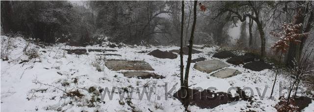
The site
was found to contain 28 stećaks, all chest-shaped with the exception of one
gabled (sarcophagus-like) tombstone (no. 22), and in good condition. They are
arrayed in rows running north-south, with the tombstones themselves lying
west-east, with the exception of stećaks 8, i, 10, 11 and 19(7), which are lying north-south.
The stećaks, which are in good condition, were made of two different types of stone.
Some have sunk into the ground. Stećak no. 2 is decorated with two swastikas
and three crosses in bas- and reverse relief. A Muslim burial ground still in
use is located about 50 m to the south-east of the necropolis with stećaks.
The
petition to designate the site calls it the “Kaursko groblje (stećaks) and
Muslim burial ground (Bor), Hrđavci, Foča,” but during the survey of the
tombstones it was found that the local population call the site where the
stećaks are located “Bor,” hence the title for the Decision has been amended to
“Necropolis with stećaks at Bor in Hrđavci, Foča Municipality.”
When the
nišan gravestones were inspected by the Commission’s freelance associate Hazim
Numanagić, it was found that there are no nišans in the Muslim burial ground
that meet the criteria for designation as a national monument.
Condition of the stećaks
Stećak
no. 1. – chest, undecorated, covered with topsoil, west end visible,
lying west-east; the stećak measures 100 cm wide x 30 cm high.
Stećak
no. 2. – chest with decoration, leaning to the north, covered with lichen
and moss, lying west-east; the stećak measures 220x106x45 cm.
The west
end is decorated with three small crosses between which are two swastikas. The crosses are in relief and the swastikas
in reverse relief.
Stećak
no. 3. – chest, undecorated, sunken, western part of the top damaged,
covered with creepers, lying west-east; the stećak measures 170x73x17 cm.
Stećak
no. 4. – chest, undecorated, leaning to the north, covered with lichen
and moss, lying west-east; the stećak measures 215x92x30 cm.
Stećak
no. 5. – chest, undecorated, sunken, covered with lichen and moss, lying
west-east; the stećak measures 170x75x09 cm.
Stećak
no. 6. – chest, undecorated, sunken, covered with lichen and moss, lying
west-east; the stećak measures 175x80x07 cm.
Stećak
no. 7. – chest, undecorated, sunken, covered with lichen, lying
west-east; the stećak measures 170x75x15 cm.
Stećak
no. 8. – chest, undecorated, leaning to the east, covered with lichen
and moss, lying north-south; the stećak measures 202x92x25 cm.
Stećak
no. 9. – chest, undecorated, leaning to the east, covered with lichen
and moss, with low-growing plants between this and no. 8 and posing a threat to
both stećaks as it grows, lying north-south; the stećak measures 195x107x35 cm.
Stećak
no. 10. – chest, undecorated, leaning to the east, lying north-south; the
stećak measures 194x80x13 cm.
Stećak
no. 11. – chest with plinth, undecorated, covered with lichen and moss,
lying north-south; the stećak measures 167x42x33 cm; the plinth measures
198x62x20 cm.
A feature
is that there is no plinth on the west side, which has not been worked in the
same way as the other three sides.
Stećak
no. 12. – chest, undecorated, sunken, lying west-east; the stećak
measures 165x70x05 cm.
Stećak
no. 13. – chest, undecorated, of fine workmanship, lying west-east; the
stećak measures 190x95x28 cm.
Stećak
no. 14. – chest, undecorated, partly sunken, edges of the top damaged,
lying west-east; the stećak measures 156x100x15 cm.
Stećak
no. 15. – chest, undecorated, leaning to the south, lying west-east; the
stećak measures 215x90x19 cm.
Stećak
no. 16. – chest, undecorated, covered with lichen, lying west-east; the
stećak measures 200x106x18 cm.
Stećak
no. 17. – chest, undecorated, covered with lichen and moss, lying
west-east; the stećak measures 208x107x25 cm.
Stećak
no. 18. – chest, undecorated, leaning to the north, lying west-east; the
stećak measures 170x97x28 cm.
Stećak
no. 19. – chest, undecorated, completely sunken, covered with topsoil and
grass, located on the approach path to the necropolis, lying west-east; the
stećak measures 116 cm visible length x 07 cm visible height.
Stećak
no. 20. – chest, undecorated, sunken, covered with lichen, lying
west-east; the stećak measures 150 x 120 x 11 cm.
Stećak
no. 21. – chest, undecorated, with earth piled up against the east end,
lying west-east; the stećak measures 187x90x10 cm.
Stećak
no. 22. – gabled, undecorated, sunken to roof height and leaning to the
south, covered with lichen and moss, lying west-east; the stećak measures 187x
85 x visible height 18 cm.
Stećak
no. 23. – chest, undecorated, with earth piled up against the east end,
covered with lichen and moss, lying west-east; the stećak measures 150x94x27
cm.
Stećak
no. 24. – chest, undecorated, covered with lichen and moss, lying
west-east; the stećak measures 230x110x22 cm.
Stećak
no. 25. – chest, undecorated, partly sunken, covered with lichen and
moss, lying west-east; the stećak measures 190x135x12 cm.
Stećak
no. 26. – chest, undecorated, covered with lichen and moss, lying
west-east; the stećak measures 168x70x15 cm.
Stećak
no. 27. – chest with plinth, undecorated, piled up with earth to plinth
height on the north side, covered with lichen and moss, lying west-east; the
stećak measures 157x57x38 cm; the plinth measures 185x88x20 cm.
Stećak
no. 28. – chest, undecorated, covered with lichen and moss, lying
west-east; the stećak measures 205x90x10 cm.
3. Legal status to date
The
findings of an inspection of the documentation on statutory protection of the
property during the preliminary procedure are as follows:
The
Regional Plan for BiH to 2000 lists 34 sites of necropolises with stećaks (1459
stećaks) in Foča Municipality, without precise identification(8).
Letter
ref. 07-40-4-4069-1/11 of 28 September 2011 from the Institute for the
Protection of Monuments under the Federal Ministry of Culture and Sport states
that the necropolis of stećaks at Kaursko groblje and the nišan gravestones at
Bor in the village of Hrđavci, Foča Municipality was not recorded under that
heading and was not on the Register of Cultural Monuments of the Socialist
Republic of Bosnia and Herzegovina.
4. Research and
conservation-restoration works
No
investigative or conservation-restoration works have been carried out.
5. Current condition of the
property
The
findings of on-site inspections conducted on 13 September 2011, 15
August 2012 and 5 December 2012 are as follows:
-
as plant growth resumes in
spring the necropolis becomes overgrown with grass and low-growing plants,
-
some of the tombstones are
chipped, damaged, overturned or partly or wholly sunken into the ground, and
are covered to a greater or lesser extent with plant organisms (lichen and
moss),
-
the survey of the
necropolis uncovered 19 stećaks, but after the petitioner had cleared the site
to remove low-growing plants and grass the final number was found to be 28,
-
the petitioner has erected
a signpost bearing the words Nekropola Hrđavci by the road to the village, to
direct passers-by to the site with the stećaks.
6. Specific risks
-
deterioration of the site
as a result of long-term neglect
-
adverse effects of the
elements
-
self-sown vegetation.
III – CONCLUSION
Applying
the Criteria for the adoption of a decision on proclaiming an item of property
a national monument (Official Gazette of BiH nos. 33/02 and 15/03), the
Commission has enacted the Decision cited above.
The
Decision was based on the following criteria:
A. Time
frame
B. Historical
value
C. Artistic and aesthetic value
C.i. quality of workmanship
C.ii. quality of materials
C.v. value of details
C.vi. value of construction
D. Clarity
(documentary, scientific and educational value)
D.i. material evidence of a lesser known
historical era
E. Symbolic value
E.ii. religious value
E.iii. traditional value
E.v. significance for the identity of a group of
people
G. Authenticity
G.i. form and design
G.ii. material and content
G.iii. use and function
G.iv. traditions and techniques
G.v. location and setting
The
following documents form an integral part of this Decision:
-
Ownership documentation
-
Copy of cadastral plan no.
5, scale 1:2500, for c.p. no. 800 (new survey), title deed no. 71, c.m.
Rodijelj, Foča, Republika Srpska, Bosnia and Herzegovina, supplied to the
Commission on 20 November 2012 by Foča
Municipality, Department
of Social Affairs.
-
Documentation on prior
protection of the property
-
Letter ref.
07-40-4-4069-1/11 of 28 September 2011 from the Institute for the Protection of
Monuments under the Federal Ministry of Culture and sport, supplying the
Commission with details of the listing and prior statutory protection of the
necropolis with stećaks at Bor in Hrđavci, Foča.
-
Letter ref.
07/1.20/624-650-1/2011 of 28 September 2011 from the RS Institute for the
Protection of the Cultural and Natural Heritage notifying the Commission to
Preserve National Monuments that the RS Institute has no record of the listing
and prior statutory protection of the necropolis with stećaks at Bor in
Hrđavci, Foča.
-
Photodocumentation
-
Photographs of the
property taken on 13 September 2011, 15 August 2012 and 5 December 2012 by
historian Zijad Halilović using Canon EOS 450D digital camera.
-
Technical documentation
-
Technical drawings of the
necropolis (plan of the necropolis, drawings of the tombstones) measured and
surveyed on 15 August and 5 December 2012 by historian Zijad Halilović and
Milka Grujić BSc.Arch.
Bibliography
During
the procedure to designate the monument as a national monument of Bosnia
and Herzegovina the following works were
consulted:
1980. Various authors. Prostorni plan Bosne i Hercegovine, faza b –
valorizacija, prirodne i kulturno-historijske vrijednosti (Regional Plan
for Bosnia and Herzegovina,
phase B – valorization of natural, cultural and historical assets). Sarajevo: Institute for Architecture and Town and Country
Planning of the Faculty of Architecture in Sarajevo
and the Planning Authority of Bosnia and
Herzegovina in Sarajevo,
1980.
1981. Kovačević-Kojić, Desanka. “Arhivsko-istorijska istraživanja
Gornjeg Podrinja.” (Archival and historical research into the upper Drina region). Sarajevo:
Naše starine XIV-XV, 1981, 109.-125
1988. Arheološki leksikon Bosne i Hercegovine (Archaeological
lexicon of BiH), Vol. 3. Sarajevo: National Museum
of Bosnia and Herzegovina,
1988, 119-132
1988. Bojanovski, Ivo. “Gornje Podrinje (Municipium S . . .?),”
in: Bosna i Hercegovina u antičko doba (The upper Drina [Municipium
S...?] in Bosnia and
Herzegovina in Antiquity). Sarajevo: ANUBiH vol.LXVI, CBI vol. 6. 1988, 204,
205
2009. Živković, Tibor. Gesta regum Sclavorum. Belgrade:
Istorijski institut Beograd – Manastir Ostrog,
Tom II, 2009
(1) Google Maps –
http://maps.google.hr (17 August 2012)
(2) Production
in Bosnia's
mines was stepped up during the reign of Stjepan II Kotromanića (1322-1353),
peaking in the first half of the 15th century. After 1430, the only mines to
show significantly increased production were the silver mines (Srebrenica,
Fojnica, Kreševo, Deževice). The presence of Saxon miners in tthe upper Drina valley area in the 12th and 13th centuries has not
been fully proven. It is possible that I. Bojanovski associates Saxon activity
in this pat of the world with their presence in eastern Serbia. The
Rascian kings Stefan Vladislav (1234-1243) and Stefan Uroš I (1243-1276) are
known to have brought in Saxon miners to revive the mining and metal-working
industry in Serbia.
The Saxons came from the Romanian town of Erdelj,
bringing their know-how, technology, and the mining laws and customs then
prevailing in Saxony.
(3) Bojanovski,
Ivo. “Gornje Podrinje (Municipium S . . .?),” in: Bosna i Hercegovina
u antičko doba, Sarajevo:
Djela Centra za balkanološka ispitivanja ANUBIH LXVI (6), 1988, 204 – 210.
(4) In Gesta
regum Sclavorum Tibor Živković analyzed both redactions of the Chronicle
of the Doclean priest – the “Croatian redaction” (CR) originally
written in Latin, and the “Latin redaction” (LR) – and the relationship between
the two. Analysis of the narrative revealed that both CR and LR were written by
the same person, suggesting that HR was the original and LR the final version.
He believed that the author of the Chronicle was a foreigner who, before
settling in Dalmatia, had travelled and read
widely, and that he was a member of the Catholic Church. The analysis of the
documents and events led him to believe that the Doclean priest wrote Gesta
regum Sclavorum in the latter half of the 13th century, not the mid 12th
century as was the prevailing scholarly opinion. Živković, Tibor, Gesta
regum Sclavorum, Beograd: Istorijski institut Beograd – Manastir Ostrog,
Tom II, 2009.
(5) Kovačević-Kojić,
Desanka, “Arhivsko-istorijska istraživanja Gornjeg Podrinja,” Sarajevo: Naše
starine XIV-XV, 1981, 109,110.
(6) Taken on
site by GPS on 5 December 2012.
(7)
Translator's note: however, the description below gives the orientation of no.
19 as west-east.
(8) Grupa autora, Prostorni
plan Bosne i Hercegovine, faza b – valorizacija, prirodne i
kulturno-historijske vrijednosti, Sarajevo:
Institut za arhitekturu, urbanizam i prostorno planiranje Arhitektonskog
fakultet u Sarajevu i Urbanistički zavod za Bosnu i Hercegovinu Sarajevo, 1980,
51.