Status of monument -> National monument
Pursuant
to Article V para. 4 Annex 8 of the General Framework Agreement for Peace in Bosnia and Herzegovina
and Article 39 para. 1 of the Rules of Procedure of the Commission to Preserve
National Monuments, at a session held from 6 to 8 November 2012 the Commission
adopted a
D E C I S
I O N
I
The
natural and architectural ensemble of the Radetina Tower with natural heritage,
Cazin Municipality, is hereby designated as a National Monument of Bosnia
and Herzegovina (hereinafter: the National
Monument).
The
National Monument consists of the Radetina
Tower, the cave where the
tower is located, the Radetina brook and the natural surroundings of the Tower.
The
National Monument is located on a site designated as cadastral plot no. 62 (new
survey), corresponding to c.p. nos. 937/70, 937/63 and 937/64 (old survey),
title deed no. 38/01, Land Register entry nos. 834 and 1370, cadastral
municipality Cazin, Municipality Cazin, Federation of Bosnia and Herzegovina, Bosnia and Herzegovina.
The
provisions relating to protection measures set forth by the Law on the
Implementation of the Decisions of the Commission to Preserve National
Monuments, established pursuant to Annex 8 of the General Framework Agreement
for Peace in Bosnia and Herzegovina (Official Gazette of the Federation of BiH
nos. 2/02, 27/02, 6/04 and 51/07) shall apply to the National Monument
II
The
Government of the Federation of Bosnia and Herzegovina (hereinafter: the
Government of the Federation) shall be responsible for providing the legal,
scientific, technical, administrative and financial measures necessary for the
protection, conservation and presentation of the National Monument.
The
Government of the Federation shall provide the resources for conducting
archaeological works and producing the technical documentation required for the
protection and preservation of the National Monument.
The
Commission to Preserve National Monuments (hereinafter: the Commission) shall
determine the technical requirements and secure the funds for preparing and setting
up signboards with basic details of the monument and the Decision to proclaim
the property a National Monument.
III
To ensure
the on-going protection of the National Monument on the site defined in Clause
1 para. 3 of this Decision, the following protection measures are hereby
stipulated:
built heritage
-
all works are prohibited
other than investigative, archaeological and conservation-restoration works on
the Tower, including works designed for the presentation of the monument, with
the approval of the federal ministry responsible for regional planning and
under the expert supervision of the heritage protection authority of the
Federation of Bosnia and Herzegovina (hereinafter: the heritage protection
authority);
-
during structural repair,
conservation and restoration works on the National Monument, original materials
and binders shall be used wherever possible;
-
repairs shall be carried
out using the existing stone blocks;
-
the site of the National
Monument shall be open and accessible to the public, and may be used for
educational and cultural purposes;
-
the site defined in Clause
1 para. 3 of this Decision is a potential archaeological site, and therefore no
works that could in any way alter the site or pose a threat to the monument may
be carried out without the supervision of the heritage protection authority and
the presence of an archaeologist;
-
construction or works that
could have the effect of altering the site are prohibited, as is the erection
of temporary facilities or permanent structures not designed solely for the
protection and presentation of the National Monument;
-
a programme for the
refurbishment, presentation and routine maintenance of the National Monument
shall be produced and implemented;
-
the approach paths shall
be cleared and made good;
-
the dumping of waste is
prohibited.
natural heritage
-
a detailed plan shall be
produced for the preservation of the natural setting, consisting of the cave,
the Radetina brook and the natural stone bridge, to protect the entire area
without compromising its existing state and the ecological balance;
-
existing tall vegetation
and specific plant species shall be preserved;
-
the exploitation of the
woodland is prohibited with the exception of felling for tree health and
vitality;
-
signposts and route
markers shall be erected.
With a
view to protecting the natural and built ensemble, a buffer zone is
hereby prescribed, consisting of the area bordering the National Monument to
the north as far as Radetina brook (c.p. nos. 1450 and 1451), to the east of
c.p. nos. 63 and 64, and to the south and west up to and including the approach
road (c.p. nos. 61, 65 and 68).
Measures
to protect the natural values of the site shall apply in the buffer zone. The
extraction of stone, the felling of trees except for tree health and vitality,
the construction of industrial facilities and major infrastructure and of any
facility that could endanger the National Monument during construction or
operation are prohibited.
IV
All
movable artefacts found during the course of the archaeological survey shall be
deposited in the nearest museum able to provide the necessary personnel,
material and technical conditions or in the National Museum of Bosnia and
Herzegovina in Sarajevo,
catalogued, and suitably presented.
By way of
exception to the provisions of para. 1 of this Clause, until such time as the
National Museum of Bosnia and Herzegovina reopens, and if the nearest museum is
unable to provide the necessary personnel, material and technical conditions,
the principals of the archaeological investigations are required to submit a
written request to the Commission to specify the institution where the
archaeological finds shall be temporarily housed.
All
movable and immovable archaeological material found during the course of the
archaeological investigations shall be professionally catalogued.
Upon
completion of the archaeological works the archaeologist leading the
investigations shall submit a report to the Commission and to the institution
that conducted the investigations.
The
archaeologist leading the investigations must have access to all the movable
and immovable archaeological material found during the course of the
investigations and until his/her report is completed, for a period not
exceeding three years.
All
immovable finds shall be conserved in situ as the archaeological
investigations proceed, and the movable archaeological material shall be
conserved and placed for safe keeping in a suitable storage facility.
Upon
receipt of a report on the investigations conducted, the Commission shall
identify which movable artefacts shall be subject to protection measures to be
determined by the Commission.
The
removal of the movable artefacts referred to in para. 1 of this Clause from Bosnia and Herzegovina
is prohibited.
By way of
exception to the provisions of paragraph 7 of this Clause, the temporary
removal from Bosnia and Herzegovina of the movable artefacts for the purposes
of display or conservation shall be permitted if the leader of the
investigations determines that a given artefact must be catalogued abroad, and
provides evidence to that effect to the Commission, which may permit the
temporary removal of the artefact from the country subject to detailed
conditions for its export, treatment while out of the country and return to Bosnia and Herzegovina.
V
All
executive and area development planning acts are hereby revoked to the extent
that they are not in accordance with the provisions of this Decision.
VI
Everyone,
and in particular the competent authorities of the Federation of Bosnia and
Herzegovina, the Canton, and urban and municipal authorities, shall refrain
from any action that might damage the National Monument or jeopardize the
preservation thereof.
VII
The
Government of the Federation, the federal ministry responsible for regional
planning, the heritage protection authority, and the Municipal Authorities in
charge of urban planning and land registry affairs, shall be notified of this
Decision in order to carry out the measures stipulated in Articles II to VI of
this Decision, and the Authorized Municipal Court shall be notified for the
purposes of registration in the Land Register.
VIII
The
elucidation and accompanying documentation form an integral part of this
Decision, which may be viewed by interested parties on the premises or by
accessing the website of the Commission (http://www.kons.gov.ba)
IX
Pursuant
to Art. V para 4 Annex 8 of the General Framework Agreement for Peace in Bosnia and Herzegovina,
decisions of the Commission are final.
X
This
Decision shall enter into force on the day following its publication in the
Official Gazette of BiH.
This
Decision has been adopted by the following members of the Commission: Zeynep
Ahunbay, Martin Cherry, Amra Hadžimuhamedović, Dubravko Lovrenović, and
Ljiljana Ševo.
No:06.2-2.3-73/12-35
7 November 2012
Sarajevo
Chair of
the Commission
Ljliljana
Ševo
E l u c i
d a t i o n
I – INTRODUCTION
Pursuant
to Article 2, paragraph 1 of the Law on the Implementation of the Decisions of
the Commission to Preserve National Monuments, established pursuant to Annex 8
of the General Framework Agreement for Peace in Bosnia and Herzegovina, a
“National Monument” is an item of public property proclaimed by the Commission
to Preserve National Monuments to be a National Monument pursuant to Articles V
and VI of Annex 8 of the General Framework Agreement for Peace in Bosnia and
Herzegovina and property entered on the Provisional List of National Monuments
of Bosnia and Herzegovina (Official Gazette of BiH no. 33/02) until the Commission
reaches a final decision on its status, as to which there is no time limit and
regardless of whether a petition for the property in question has been
submitted or not.
On 9
February 2010 the Bihać Institute for the Protection of the Cultural Heritage submitted
a proposal/petition to the Commission to designate the Radetina
Tower in Cazin
Municipality as a national monument of BiH.
Pursuant
to the provisions of the law, the Commission proceeded to carry out the
procedure for reaching a final decision to designate the Property as a National
Monument, pursuant to Article V of Annex 8 and Article 35 of the Rules of
Procedure of the Commission to Preserve National Monuments.
Statement of Significance
Like
other mediaeval fortifications in the Una valley, with which it formed part of
the system of defences in the frontier region, the Radetina Tower
was built on a precipitious, inaccessible height. The earliest reference to the
tower is as a holding of the Kobasić lords, who ruled Brekovica in the 15th and
16th centuries. In his 1536 report on the towers and forts of the Krajina
(military frontier region), General Ivan Lenković states that the Radotina
(Radetina) Tower, which is in the village of Ćoralići, is uncared for, and that
there is no need to preserve it; rather, it should be demolished. The tower
came under Ottoman rule after 1577, and from then on was used as a karaula
(watch-tower) and guard house, giving the area the name Karaula.
The
natural setting of the tower, consisting of the cave in which Radetina brook
rises, a natural stone bridge and rich mixed woodland, forms an integral whole
with the built heritage of this mediaeval fortified structure.
II – PRELIMINARY PROCEDURE
During
the procedure preceding the adoption of a final decision to proclaim the
property a national monument, the following documentation was inspected:
-
documentation on the
location and current owner and user of the property (copy of cadastral plan,
copy of land register entry, proof of title).
-
details of the current
condition and use of the property, including a description and photographs,
details of war damage, details of rehabilitation works on the property and of
the project, materials and building methods applied during rehabilitation.
-
historical, architectural
and other documentary material on the property, as set out in the bibliography
forming part of this Decision.
-
details of statutory
protection to date.
-
the views of the owner in
writing, expressing full agreement to the designation of the property as a national monument of BiH.
Pursuant
to Article V para. 2 of Annex 8 of the General Framework Agreement for Peace in
Bosnia and Herzegovina and Article 37 of the Rules of Procedure of the
Commission, before rendering a final decision designating a property as a
national monument, the Commission is required to provide the owner of the
proposed monument, the person submitting the petition, the institutions
responsible for heritage, professional and academic institutions, experts and
scholars, as well as other interested parties, to express their views.
Accordingly,
the Commission sent a letter ref. 07.1-35.2-8/11-189 dated 14 November 2011
requesting documentation and views on the designation of the Radetina Tower in
Cazin as a national monument of Bosnia and Herzegovina to Cazin Municipality
(mayor and department responsible for town planning and cadastral affairs), the
Federal Ministry of Regional Planning, the Institute for the Protection of
Monuments under the Federal Ministry of Culture and Sport and the Bihać
Institute for the Protection of the Cultural Heritage.
As of the
date on which this Decision was rendered, the Commission had received the
following documentation:
-
on 8 February 2010 the
Bihać Institute for the Protection of the Cultural Heritage submitted a
petition for the protection of the Radetina
Tower in Cazin under
cover of letter ref. 0066/10, followed by letter ref. 06-759/11 of 26 October
2011 supplying additional details and a proposal for repairs to the property.
-
letter ref. 03-23-2-272/12
dated 2 March 2012 from the Federal Ministry of Regional Planning notifying the
Commission to Preserve National Monuments that it has no information or
documentation on the property in question.
-
letter ref.
07-40-4-4297-1/11 dated 19 October 2011 from the Institute for the Protection
of Monuments under the Federal Ministry of Culture and Sport supplying the
following documentation for the Radetina Tower: ruling on statutory protection;
ruling on entry in the Register and File on the property.
-
letter ref. 03-40-8762/12
dated 23 August 2012 from the Department of General Administration and Social
Affairs, Cazin Municipality, supplying the following
documentation:
-
copy of cadastral plan no.
2 of 25 July 2012
-
copy of title deed no.
38/01 of 23 July 2012
-
Land Register entry nos.
834 and 1370.
The
findings based on the review of the above documentation and the condition of
the site are as follows:
1. Details of the property
Location
Cazin,
which is 26 km to the north of Bihać, on the road to Velika Kladuša, is the
largest town on the left bank of the Una. The Radetina Tower
is 4 km from Cazin, on a precipitous, inaccessible height north-west of Cazin,
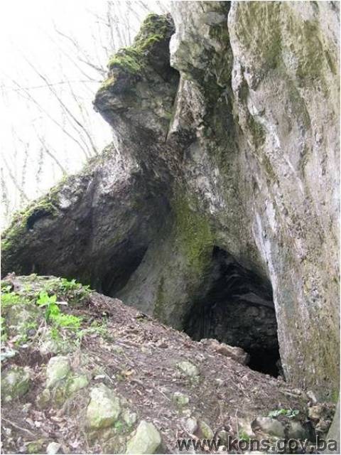
between the villages of Ćoralići and Gornja Koprivna. The entrance to the tower
was probably through the cave beneath, in which Radetina brook rises.
The
National Monument is located on a site designated as cadastral plot no. 62 (new
survey), corresponding to c.p. nos. 937/70, 937/63 and 937/64 (old survey),
title deed no. 38/01, Land Register entry nos. 834 and 1370, cadastral municipality
Cazin, Municipality Cazin, Federation of Bosnia and Herzegovina, Bosnia and
Herzegovina.
Historical background(1)
The Cazin region was already inhabited in prehistoric times, as
evidenced by the remains of various artefacts of pottery, stone, bronze and
iron, found at Čungar, Gradina, Selište and elsewhere. The Bihać area was
settled by the Iapodes in the 8th century BCE, and it is likely that they were
also present in the Cazin area. In the early years CE Romans settled in the
area. The earliest reference to Cazin in historical sources dates from 1522,
when the Ottomans conquered Knin and Cazin became the seat of the bishops of
Knin. Cazin was held for a time by Petar Keglević, who in 1535 surrendered it
on the king's orders to the new bishop of Knin, Canon Petar of Ripač. It was
while the latter was holding court there, in 1539, that the Ottomans took the
town.
A
frontier garrison was based in Cazin from 1553. In July 1576 the Ottomans, led
by Ferhad pasha Sokolović, finally took Cazin and Bužim. By 1577 an Ottoman
garrison of 50 cavalrymen and 150 infantrymen was already based in Cazin (Lopašić,
1943, 132). The following year Ferhad pasha surrendered Cazin without a
fight to General Ivan Ferenberg, only to retake it, this time for good, later
that same year (Lopašić, 120-123, Kreševljaković, 1953, 32).
In 1584
the Ottomans embarked on a further reinforcement of the fort in Cazin, which
was one of the most strongly fortified towns on the border between the two
empires. In or around 1570 the Kamengrad kadiluk [area under the
jurisdiction of a qadi – Islamic judge and administrative officer] was
established within the Bosnian sanjak, covering the nahijas [minor
administrative districts] in the Sana river
valley, to which the town of Cazin
also belonged (Šabanović, 1982, 175,181).
According
to a treaty of 1625 on the borders between the Ottoman holdings in the Krajina
and neighbouring Croatia, there were military garrisons in all the forts held
by the Ottomans in the Krajina, including Cazin (Lopašić, 1943, 31).
In the
18th century, Cazin formed part of the Ostrožač captaincy, and did not have a dizdar
[fortress commander] of its own. In the 19th century Cazin belonged to the
Bihać kajmakamluk (district) and the Cazin or Ostrožac mudirluk (Šabanović,
1982, 233).
The
Gračanica, Radetina and Bišovac towers formed a triangle, designed to protect
Mutnik Fort, which stood at the centre of the triangle. Catholic overlords held
Mutnik Fort, probably the major fort in the area, until it was occupied by the
Ottomans in the early 16th century.
The
Radetina Tower, together with the other mediaeval forts in the Una-Sana area,
formed part of the frontier defences. The earliest reference to the Radetina Tower is as a holding of the Kobasić
lords, who ruled Brekovica in the 15th and 16th centuries. In his 1536 report
on the towers and forts of the Krajina (military frontier region), General Ivan
Lenković states that the Radotina (Radetina) Tower, which is in the village of
Ćoralići, is uncared for, and that there is no need to preserve it; rather, it
should be demolished. The tower came under Ottoman rule after 1577, and from
then on was used as a karaula (watch-tower) and guard house, giving the
area the name Karaula.
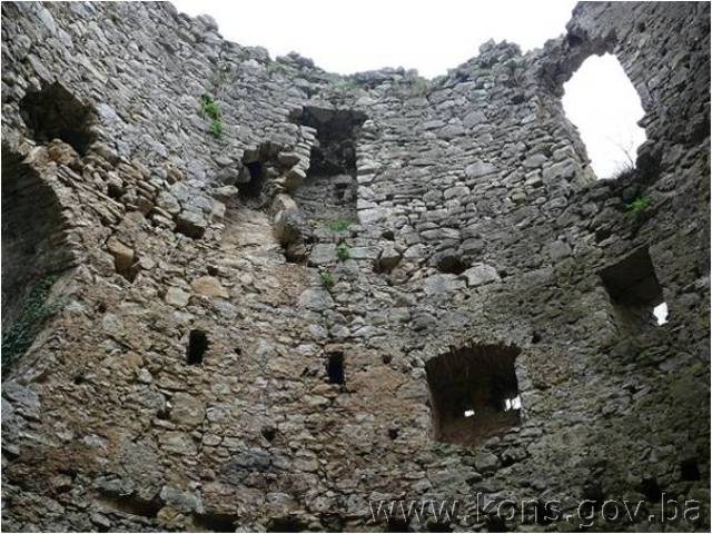
2. Description of the property
The tower
is a tall and relatively narrow building, erected to be used as a fortified
manor. It is round in plan, with an interior diameter of approx. 6.00 m. Being
built on sloping high ground, it varies in height from approx. 8.00 m to 10.00
m. The walls, which are approx. 1.40 m thick, were built of rubble stone.
The
entrance to the tower is from the north, once reached via a corridor on the
south side. This is now in ruins, making it almost impossible to enter the
tower.
The tower
has no roof. The remains of the balcony which served as a lookout-post can be
seen above the entrance.
Small
openings serving as loopholes can be seen from the inside.
The
position of wooden tie beams can be seen at heights of approx. 2.00, 4.00 and
6.00 m above the probable floor level.
The walls
of the tower also had windows serving as lookouts, which are splayed towards
the inside.
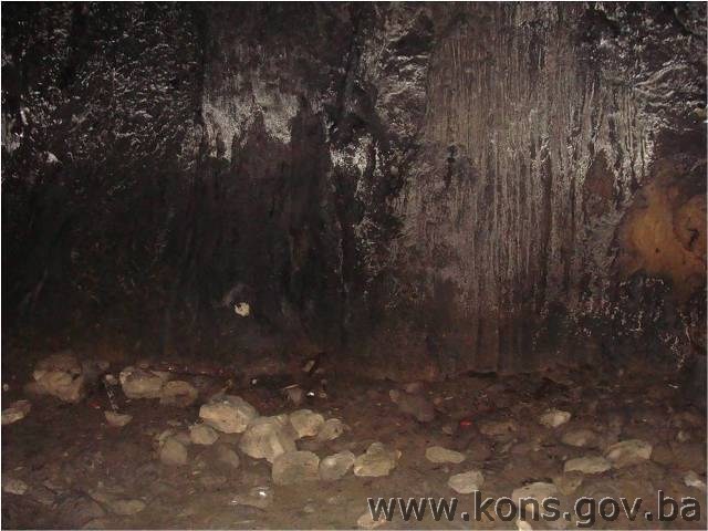
Natural heritage(2)
The
Radetina Tower stands in an area of hydrographic, geological and floristic
interest, on a precipitous, inaccessible height at the foot of which is a natural
cave(3) and a stone bridge.
The
natural entrance to the cave was originally much larger, but is now partly
walled up with rubble stone, leaving an aperture about 2.00 m wide and 1.5 m
high. The first chamber is oval in plan, with a width of about 5.40 m and a
length of about 11 m. This chamber is about 3.00 in height. The cave then
narrows, widening out again after about 15 m into a second chamber the size of
which is not known. Radetina brook rises in the cave.
Geologically,
the Cazin(4) area is Mesozoic in age(5), with Radetina located on a Jurassic enclave between upper
Cretaceous strata to the east and Miocene to the west. It too is geologically
diverse, with the wider area dominated by the middle Jurassic (Dogger), whereas
tufa is typical of the wider region. The immediate area of the Radetina Tower
is of the lower Jurassic (Malm) period(6).
Lithologically,
the entire area is dominated by massive limestone and dolomite (the Cazin
dolomite bed known as Džehveruša, estimated to contain “about a hundred
million m3”of dolomite, is well known). The Radetina area itself consists of
laminated limestone, dolomite and platy limestone with chert – Lemeš deposits
with microfossils Clypeina jurassica and Pianella grudii.(7)
The Cazin
region is characterized hydrologically by three catchment areas: that of the
River Una, with its tributary the Dobrenica, that of the River Korana, with its
tributaries the Toplica, Mutnica, Crnaja and Grahova rivers, and that of the
River Glina, with its tributaries the Rijeka, Mircoljica and Pivnica rivers(8). The waters from the wider Radetina area gravitate towards the
Glina catchment area, while Radetina itself has more than thirty free-flowing
springs (average output less than three l/s) feeding Kelečevac brook(9).
The area
has a moderate continental climate, with Cazin experiencing fairly harsh
winters and hot summers, markedly influenced by local conditions(10).
Flora
The
vegetation of the Cazin area is lush, characterized by mesophile oak forests
with sessile oak and common hornbeam communities (Querco – Carpinetum Horv.
et al. 1974)(11).
Stefanović,
V.(12) also
includes Fagetalia among the mesophile hornbeam woodland, but identifies the Erythronio
– carpinetum illyricum Horvat et.al. 1974 community, describing it as
sessile oak and hornbeam forest on moderately acid brown, illimerized, clayey
soils(13).
The Cazin
region is known for its disjunct range of sweet chestnut forest (Querco –
Castanetum)(14).
As well
as sweet chestnut, the tree layer contains Quercus petraea, Fagus sylvatica,
Betula verrucosa, and Carpinus betulus. The shrubs and ground
vegetation consist of acidophile species: Genista tinctoria. Genista
germanica, Juniperus communis, Frangula alnus, Rubus hirtus, Vaccinium
myrtillus, Hieracium murorum, Hieracium umbellatum, Lazula pilosa, Lazula
albida, Veronica officinalis, Pteridium aquilinum, Calluna vulgaris, Potentilla
erecta, and Melamyrum pratense ssp. vulgatum. There is also commonly
a well developed moss layer with the species Polytrichum formosum,
Leucobrium glaucum, and Dicranum scoparium. Unlike the sessile
oak-hornbeam association, where the structure is more complex and the shrub
layer much more highly developed, this community is characterized by its
uniformity, and the dominance of acidophile species.
Fauna
The
forest cover and presence of potable water provide a suitable habitat for
several species of mammals, birds, amphibians and invertebrates.
There are
no documented indicators for the state of the fauna of Bosnia and Herzegovina
(and consequently the area here in question) except for an overview of the
state of the mammalian fauna (Kotrošan et. al.(15)), with a systematic list of fauna and a bibliography giving 153
sources, providing a systematic and reliable basis for this subject.
The
underlying features of the habitats of the surroundings of the Radetina Tower
indicate that species of the following are certainly to be found: Mammalia,
Aves, Ichthyofauna(16), Reptilia(17), tortoises, Amphibia, and Crustacea(18).
3. Legal status to date
An
inspection of the protection of the property reveals that:
-
the architectural ensemble
of Radetina Tower was protected by the Institute for the Protection of Cultural
Monuments and Natural Rarities in Sarajevo, People’s Republic of Bosnia and
Herzegovina, ruling no. 02-708-3 of 23 October 1962;
-
pursuant to ruling no.
1092/51 of 28 December 1951 the Radetina Tower was inscribed in the register of
immovable cultural monuments under serial no. 63;
-
the 1980 to 2002 Regional
Plan for Bosnia and Herzegovina, phase B, valorization, lists the Radetina
Tower under category II.
4. Research and
conservation-restoration works
-
no investigative or
conservation-restoration works have been carried out;
-
in 2011 the Bihać
Institute for the Protection of Monuments produced an action plan that covered
a survey of the wider geodetic area, archaeological investigations of the
Radetina Tower, and clearing and laying access paths.
5. Current status of the property
The
findings of an on-site inspection on 10 July 2012 are as follows:
-
the site is very difficult
of access;
-
the entire area around the
tower is overgrown with tall and low-growing vegetation and scattered with
fallen stone;
-
the walls of the tower are
covered inside and out with dense plant growth;
-
the walls are in very poor
condition or almost ruinous in places through neglect;
-
the approach paths are in
very poor condition, fallen away or non-existent in places, making it
impossible to reach the tower;
-
the cave below the tower
has not been investigated and there is no way of entering the tower through the
cave.
6. Specific risks
-
adverse effects of the
elements
-
self-sown vegetation
-
neglect
III – CONCLUSION
Applying
the Criteria for the designation of property as a national monument (Official
Gazette of BiH nos. 33/02 and 15/03), the Commission has enacted the Decision
cited above.
The
Decision was based on the following criteria:
A. Time frame
B. Historical value
C. Artistic and aesthetic value
C.i. quality of workmanship
C.iii. proportions
C.vi. value of construction
D. Clarity
(documentary, scientific and educational value)
D.i. material evidence of a lesser known
historical era
D.ii. evidence of historical change
D.iv. evidence of a particular type, style or
regional manner
E. Symbolic value
E.i. ontological value
E.iii. traditional value
E.v. significance for the identity of a group of
people
The
following documents form an integral part of this Decision:
-
Ownership documentation
-
copy of cadastral plan no.
2, scale 1:25000, issued on 25 July 2012 by the Department of Proprietary
Rights, Geodetics and Cadastral Afairs, Sector for Geodetics and Cadastral
Affairs, Cazin Municipality
-
copy of title deed no.
38/01 issued on 23 July 2012 by the Department of Proprietary Rights, Geodetics
and Cadastral Afairs, Sector for Geodetics and Cadastral Affairs, Cazin
Municipality
-
Photodocumentation
-
photographs of the
Radetina Tower in Cazin taken in July 2012 by members of staff of the
Commission to Preserve National Monuments
-
Other documentation
-
ruling no. 02-708-3 of 23
October 1962 issued by the Institute for the Protection of Cultural Monuments
and Natural Rarities in Sarajevo, People’s Republic of Bosnia and Herzegovina
-
ruling no. 1092/51 of 28
December 1951, pursuant to which the Radetina Tower was inscribed in the
register of immovable cultural monuments under serial no. 63
Bibliography
During
the procedure to designate the property as a national monument, the following
works were consulted:
1904. Truhelka, Ćiro. Naši gradovi, opis najljepših sredovječnih
gradova Bosne i Hercegovine (Our Towns, Description of the Most Beautiful
Old Towns of Bosnia and Herzegovina). Sarajevo: Naklada Knjižare J. Studnička
and others, 1904.
1934. Kreševljaković, Hamdija. Cazin i okolina (Cazin and
Environs). Sarajevo: 1934.
1943. Lopašić, Radoslav. Bihać i bihaćka krajina (Bihać and the
Bihać Krajina), 2nd ed. Zagreb: 1943.
1952. Kreševljaković, Hamdija. “Prilozi povijesti bosanskih gradova pod
turskom upravom”, Prilozi za orijentalnu filologiju i istoriju
jugoslovenskih naroda pod turskom vladavinom (Contributions to the History
of Bosnian Towns under Turkish Administration, Contributions for Oriental
Philology and the History of the South Slavs under Turkish Governance), II/1951.
Sarajevo: Institute for Oriental Studies in Sarajevo, 1952, 119-184.
1953. Kreševljaković, Hamdija. “Stari bosanski gradovi,” (Old Bosnian
Towns), Naše starine I. Sarajevo: 1953, 7-45.
1957. Vego, Marko. Naselja srednjovjekovne bosanske države
(Settlements of the Mediaeval Bosnian State). Sarajevo: Svjetlost, 1957.
.
1982. Šabanović, Hazim. Bosanski pašaluk (The Bosnian pashaluk).
Sarajevo: Svjetlost, 1982.
1988. Arheološki leksikon Bosne i Hercegovine (Archaeological
Lexicon of BiH), Vol. 2. Sarajevo: National Museum in Sarajevo, 1988.
1991. Kreševljaković, Hamdija. Kapetanije u Bosni i Hercegovini
(Captaincies in BiH) Collected Works I. Sarajevo: Veselin Masleša, 1991.
1995. Popović, Marko. Srednjovekovne tvrđave u Bosni i Hercegovini
(Mediaeval Forts in Bosnia and Herzegovina), Zbornik za istoriju Bosne i
Hercegovine 1 (History of Bosnia and Herzegovina Collected Papers 1).
Beograd: Serbian Academy of Sciences and Arts, Committee for History of Bosnia
and Herzegovina, 1995, 33-55.
1995. Kruhek, M. Krajiške utvrde hrvatskog kraljevstva (Frontier
fortifications of the Kingdom of Croatia). Zagreb: 1995, 191.
2002. Mrgić-Radojčić, Jelena. Donji kraji Krajina srednjovjekovne
Bosne (Lower regions of the Krajina frontier of mediaeval Bosnia).
Belgrade: 2002.
2006. Institute for Architecture, Urbanism and Spatial Planning, Sarajevo
Spatial
plan for Cazin Municipality 2002-2020
(1) The historical details are taken
from the following Decisions issued by the Commission: the Nurija Pozderac
house in Cazin, the Bijela Stijena Fort in Stijena, Cazin Municipality, and
the Cazin Fort and mosque in Cazin.
(2) For more on the natural heritage,
see the report Zaštita prirodnog naslijeđa Kule Radetina, općina Cazin
compiled on 9 August 2012 by Enida Malešević
(3) There was probably a secret
entrance to the tower in the cave, but in the absence of investigations this is
only speculation.
(4)
Geological map – Bihać, (annexed)
(5) A total of 187 million years –
Triassic, Jurassic and Cretaceous periods
(6) Translator's note: Malm is the old
name for the upper (not lower) Jurassic
(7) The land has no visible
contaminants, pollution, degradation or devastation. The soils of the wider area are acid brown
clayey illimerized soils.
(8) “Strateški plan za vode, zaštitu
okoliša i komunalnu djelatnost općine Cazin 2010 – 2014“, Cazin
(9) Free-flowing springs are found in
the plains, unlike the hillsides where there are water-worn gullies, dry
stream-beds in which water flows only at times of high rainfall or
snow-melt. Since the plots from which
water gravitates towards Kelečevac brook are privately-owned, and the entire
area is clean and well-preserved, it is important that the local community be
encouraged and provided with incentives to raise awareness of the importance of
protecting the environment, ensure that water courses remain clean, and take
steps to prevent potential pollution. Abramov, N.N. (1974): Snabdevanje
vodom stanovništva, industrije i poljoprivrede, IP Građevinska knjiga,
Beograd)
(10) The average annual air temperature
is 9.5 °C, with an annual air temperature amplitude of 20.6 °C. The coldest
months are January, followed December and February; the warmest are July,
August and June http://bs.wikipedia.org/wiki/Cazin
(11) This woodland association is
widespread on a wide variety of soils, on the series of limestone and acid
brown soils, but avoids wet, acid soils. In altitude, it forms the transition
between the flood forests of the plains and the beech forests of the uplands
(as evidenced from the presence of Salix alba, Alnus glutinosa, and
Adenostyles alliariae). There are relatively few surviving tall sessile oak
and common hornbeam forests. Regenerated forests at various stages of
development are to be found, as in Radetina, where hornbeam is no longer an
understorey species but, as a result of the degradation of the association, has
become the dominant species. The national classification of the HR habitats of
such woodland calls it mixed oak-hornbeam and pure hornbeam woodland (Erythronio
– Carpinion association (Horvat 1958) Marinček in Mucina et. al. 1993),
belonging to the order FAGETALLA SYLVATICAE Pawl. in Pawl. et. al. 1928,
described as mesophile and neutrophile forests of the upland and hilly region,
usually beyond flood levels, in which the upper forest storey is dominated by
common or sessile oak, and the understorey by hornbeam (which may become the
dominant tree species in degraded stands). Stefanović, V. (1986): Fitocenologija
sa pregledom šumskih fitocenoza Jugoslavije, Svjetlost, Sarajevo.
(12)
Ibid.
(13) Erythronio – carpinetum
illyricum occupies hilly terrain as part of this forest along with a number
of species common to oak-hornbeam forest (e.g.. Athyrium filix femina,
Nephrodium filix mas, Polypodium vulgare, Phyllitis scolopendrium, Polystichum
lonchitis, Asplenium trichomanes, Campanula trachelium, Listera ovata, Asarum
europaeum, Cicerbita alpina, Poa bulbosa, Geranium phaeum, Ranunculus
lanuginosus, Knautia sylvatica, Saxifraga rotundifolia, Heracleum sphondylium,
Rosa pendulina, Geum rivale, Salvia glutinosa, Circaea alpina, Adenostyles
alliariae, Mycelis muralis, Anemone hepatica, Lunaria rediviva, Carex
sylvatica, Festuca sylvatica, Geranium robertianum, Asperula odorata, Galium
sylvaticum. Glechoma hederacea, Allium ursinum, Arum maculatum, etc) and differentials;
Erythronium dens canis, Lathyrus montanus, Lusula pilosa, Melampyrum
pratense, Polytrichum formosum, and Primula vulgaris).
(14) It is essential to describe this
community given its importance and the relative proximity to Radetina of the
community Querco – Castanetum illyricum Horvat et. al. 1974. It occupies
hilly drained slopes at altitudes of 150 to 600 m. It is contiguous with
sessile oak and common hornbeam forest, where it is widespread on silicates, on
leached acid brown soils, brown podsols or illimerized soils. In the tree
layer, one of the edificators is sweet chestnut, a relict from the ice age as a
result of the warm climate of the margins of the Pannonian plain.
(15) Kotrošan, D., Bjedov, V.,
Kryštufek, B., (2005): “Stanje istraženosti faune sisara Bosne i Hercegovine,”
proceedings of the Faculty of Forestry of the University of Sarajevo, no. 1,
pp. 229-55, Sarajevo (annexed)
(16) There are more than thirty
free-flowing springs in Radetina (average output less than 3 l/s), feeding
Kelečevac brook. The water is clean and there are no potential polluters (no
illegal rubbish dumps, no nearby human habitation, and such agriculture as
there is, is largely organic). Kelečevac
brook has two fish species – chub (Squalius cephalus) and common nase (Chondostroma
nasus), which belong to the Cyprinidae (carp or minnow family),
indicating their tolerance of low oxygen levels resulting from high water
temperatures in summer when water levels are low.
(17) Reptiles are fairly well
represented, and the lizards and snakes typical of the area are indicators of
good levels of biodiversity.
(18) During the on-site inspection of
Radetina tower on 10 July several juvenile specimens of the Danube crayfish,
Galician crayfish, Turkish crayfish or narrow-clawed crayfish (Astacus
leptodactylus) were observed in Kelečevac brook. Crayfish of this species
live in lowland watercourses, and are resistant to water of rather poor
physical and chemical quality, as well as tolerating wide variations in oxygen
and temperature. Unlike other European species of the Astacidae family, they
are both diurnal and noctural, resulting in higher food intakes and consequent
greater and more rapid growth than other species. The people living not only in
this region but everywhere else where the watercourses are clean should be
warned of the dangers of introducing invasive American crayfish, which are more
aggressive than the indigenous European species and compete for living space
and food, driving native species out of their habitats.
|