Status of monument -> National monument
Pursuant
to Article V para. 4 Annex 8 of the General Framework Agreement for Peace in Bosnia and Herzegovina
and Article 39 para. 1 of the Rules of Procedure of the Commission to Preserve
National Monuments, at a session held from 4 to 6 June 2012 the Commission
adopted a
D E C I S
I O N
I
The
archaeological site of Mekota, Gornji Rakani, Municipality Novi Grad, is
hereby designated as a National
Monument of Bosnia and Herzegovina
(hereinafter: the National Monument).
The
National Monument consists of a prehistoric necropolis and movable
archaeological material from the site kept in the Gallery in Novi Grad.
The
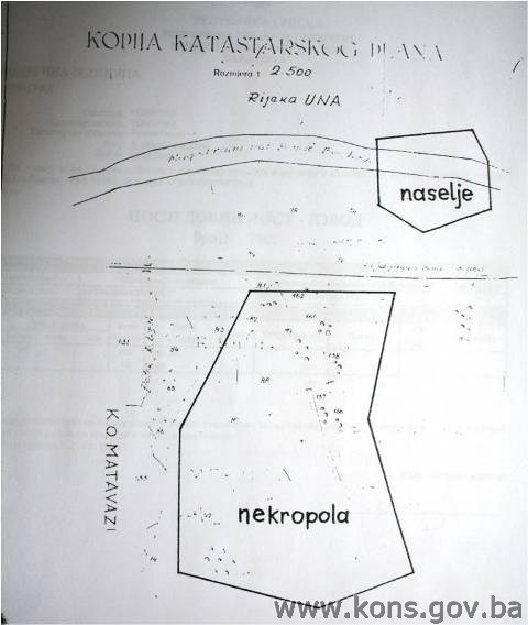
National Monument is located on a site designated as cadastral plot nos. 90
and. 157, title deed no. 76/2, c.p.nos 161 and 162, title deed no. 106/2, c.p.
no. 82, title deed no. 79/2, and c.p. nos. 88, 89, 156 and 158, title deed no.
195/1, cadastral municipality Gornji Rakani, Municipality Novi Grad, Republika
Srpska, Bosnia and Herzegovina.
The
provisions relating to protection measures set forth by the Law on the
Implementation of the Decisions of the Commission to Preserve National
Monuments, established pursuant to Annex 8 of the General Framework Agreement
for Peace in Bosnia and Herzegovina (Official Gazette of Republika Srpska no.
9/02, 70/06 and 64/08) shall apply to the National Monument.
II
The
Government of Republika Srpska shall be responsible for providing the legal,
scientific, technical, administrative and financial measures necessary for the
investigation, protection, conservation and presentation of the National
Monument.
The
Commission to Preserve National Monuments (hereinafter: the Commission) shall
determine the technical requirements and secure the funds for preparing and
setting up signboards with basic details of the monument and the Decision to
proclaim the property a National Monument.
III
To ensure
the on-going protection of the property on the site specified in Clause 1 para.
3 of this Decision, the following protection measures are hereby
stipulated:
-
all works are prohibited
other than investigative and conservation-restoration works, and works designed
for the presentation of the monument, with the approval of the ministry
responsible for regional planning in Republika Srpska and under the expert
supervision of the heritage protection authority of Republika Srpska;
-
the zone is a potential
archaeologist site and investigative works must therefore be carried out only
in the presence of an archaeologist;
-
earthworks, building works
and alterations to the morphology of the site are prohibited, as is the
erection of infrastructure and industrial facilities and plant;
-
digging on the site is
prohibited;
-
the unauthorized
collection of movable archaeological finds is prohibited;
-
measures for the technical
protection of the archaeological site may be carried out only after
archaeological excavations have been conducted;
-
the dumping of waste is
prohibited;
The
Government of Republika Srpska shall be responsible in particular for ensuring
that the following measures are carried out: archaeological
investigations, the production of an inventory and the publication of the
findings on the movable archaeological artefacts currently kept in the Gallery
in Novi Grad, and the production of a project for the presentation of the finds
in the Town Hall in Novi Grad or other premises meeting the required
conditions.
IV
All
movable artefacts found during the course of the archaeological survey shall be
deposited in the Town Hall in Novi Grad or the nearest museum able to provide
the necessary personnel, material and technical conditions or in the National
Museum of Bosnia and Herzegovina in Sarajevo,
catalogued, and suitably presented.
All
movable and immovable archaeological material found during the course of the
archaeological investigations shall be professionally catalogued.
Upon
completion of the archaeological works the archaeologist leading the
investigations shall submit a report to the Commission and to the institution
that conducted the investigations.
The
archaeologist leading the investigations must have access to all the movable
and immovable archaeological material found during the course of the
investigations and until his/her report is completed, for a period not
exceeding three years.
All
immovable finds shall be conserved in situ as the archaeological investigations
proceed, and the movable archaeological material shall be conserved and placed
for safe keeping in a suitable storage facility.
Upon
receipt of a report on the investigations conducted, the Commission shall
identify which movable artefacts shall be subject to protection measures to be
determined by the Commission.
V
The
removal of the movable artefacts found during the archaeological survey from Bosnia and Herzegovina
is prohibited.
By way of
exception to the provisions of paragraph 2 of this Clause, the temporary
removal from Bosnia and Herzegovina of the movable artefacts for the purposes
of display or conservation shall be permitted if the leader of the
investigations determines that a given artefact must be catalogued abroad, and
provides evidence to that effect to the Commission, which may permit the
temporary removal of the artefact from the country subject to detailed
conditions for its export, treatment while out of the country and return to
Bosnia and Herzegovina.
VI
All
executive and area development planning acts are hereby revoked to the extent
that they are not in accordance with the provisions of this Decision.
VII
Everyone,
and in particular the competent authorities of Republika Srpska, and urban and
municipal authorities, shall refrain from any action that might damage the
National Monument or jeopardize the preservation thereof.
VIII
The
Government of Republika Srpska, the ministry responsible for regional planning
in Republika Srpska, the ministry responsible for culture, and the heritage
protection authority of Republika Srpska, and the Municipal Authorities in
charge of urban planning and land registry affairs, shall be notified of this
Decision in order to carry out the measures stipulated in Articles II – VII of
this Decision, and the Authorized Municipal Court shall be notified for the
purposes of registration in the Land Register.
IX
The
elucidation and accompanying documentation form an integral part of this
Decision, which may be viewed by interested parties on the premises or by
accessing the website of the Commission (http://www.kons.gov.ba)
X
Pursuant
to Art. V para 4 Annex 8 of the General Framework Agreement for Peace in Bosnia and Herzegovina,
decisions of the Commission are final.
XI
This
Decision shall enter into force on the day following its publication in the
Official Gazette of BiH.
This
Decision has been adopted by the following members of the Commission: Zeynep
Ahunbay, Martin Cherry, Amra Hadžimuhamedović, Dubravko Lovrenović, and
Ljiljana Ševo.
No: 05.1-2.3-73/12-14
4 June 2012
Sarajevo
Chair of
the Commission
Amra
Hadžimuhamedović
E l u c i
d a t i o n
I – INTRODUCTION
Pursuant
to Article 2, paragraph 1 of the Law on the Implementation of the Decisions of
the Commission to Preserve National Monuments, established pursuant to Annex 8
of the General Framework Agreement for Peace in Bosnia and Herzegovina, a
“National Monument” is an item of public property proclaimed by the Commission
to Preserve National Monuments to be a National Monument pursuant to Articles V
and VI of Annex 8 of the General Framework Agreement for Peace in Bosnia and
Herzegovina and property entered on the Provisional List of National Monuments
of Bosnia and Herzegovina (Official Gazette of BiH no. 33/02) until the
Commission reaches a final decision on its status, as to which there is no time
limit and regardless of whether a petition for the property in question has
been submitted or not.
On 20
June 2003 the Novi Grad Cultural and Education Centre, Karađorđeva 71,
submitted a petition/proposal to designate the archaeological site of Mekota as
a national monument
of Bosnia and Herzegovina.
Pursuant
to the provisions of the law, the Commission proceeded to carry out the
procedure for reaching a final decision to designate the Property as a National
Monument, pursuant to Article V para. 4 of Annex 8 and Article 35 of the Rules
of Procedure of the Commission to Preserve National Monuments.
Statement of Significance
Mekota,
where the prehistoric necropolis is located, is 12 km upstream from Novi Grad,
on the right bank of the River Una, next to the main Novi Grad to Bihać road. A
prehistoric settlement has also been recorded to the north-east of the
necropolis, on the river bank. A total of 769 graves were found on the site
where archaeological excavations have been conducted, an area of 1,611 m². The
necropolis may be dated roughly to the late 9th to late 7th century BCE. Most
of the finds in the graves consist of biconical goblets laid by the skeleton,
in or beside urns, singly or in a group. The rest of the finds consist mainly
of spectacle fibulae and pendants, wire spirals and twisted torques.
A
detailed interpretation of the artefacts would constitute a significant
contribution to the study of the development of burial practices during the
late Bronze and Iron Ages in north-west Bosnia.
II – PRELIMINARY PROCEDURE
In the
procedure preceding the adoption of a final decision to proclaim the property a
national monument, the following documentation was inspected:
-
documentation on the
location of the property and the current owner and occupant (copy of cadastral
plan and Land Register entry),
-
details of the current
condition and use of the property, including a description and photographs,
data of war damage, data on restoration or other works on the property, etc.,
-
historical, architectural
and other documentary material on the property, as set out in the bibliography
forming part of this Decision.
Pursuant
to Article V para. 2 of Annex 8 of the General Framework Agreement for Peace in
Bosnia and Herzegovina and Article 37 of the Rules of Procedure of the
Commission, before rendering a final decision designating a property as a
national monument, the Commission is required to provide the owner of the
proposed monument, the person submitting the petition, the institutions
responsible for heritage, professional and academic institutions, experts and
scholars, as well as other interested parties, to express their views. Accordingly,
the Commission sent:
-
letter ref.
05.1-35.19/12-9 of 2 February 2012 to the Novi Grad department responsible for town
planning, geodetics and proprietary rights requesting documentation and views
on the designation of the archaeological site of Mekota, Novi Grad
Municipality, as a national monument of Bosnia and Herzegovina
-
letter ref.
05.1-35.2-5/12-32 of 22 February 2012 to the Novi Grad Cultural and Education
Centre requesting information on the movable archaeological artefacts from the
site
-
letter ref.
05.1-35.1-11/12-65 of 15 May 2012 to the Department of Geodetics and
Proprietary Rights Banja Luka, Novi Grad branch, requesting identification of
the old and new surveys and copies of the cadastral plan for the wider area.
In
response, the Commission has received the following documentation:
-
letter ref.
21.33/952.1-1-169/12 of 9 February 2012 from the Department of Geodetics and
Proprietary Rights Banja Luka, Novi Grad branch, supplying the Commission with
a copy of the cadastral plan, proof of title and Land Register entry
-
letter ref. 03/16-052/2/12
of 24 February 2012 from Novi Grad Municipality, Dept. of Administration,
Sector for Social Affairs, supplying the Commission with a copy of the
cadastral plan, proof of title and Decision no. 02/8-473-7/81 of 27 April 1981
ruling that the archaeological investigations at Mekota in Gornji are of public
importance and that the real property on the cadastral plots of the said site
may be expropriated
-
letter ref. 03/16-052/2/12
of 24 February 2012 from Novi Grad Municipality, Dept. of Administration,
Sector for Social Affairs, notifying the Commission that a public notice addressed
to the owners was posted on the notice board of Novi Grad Municipality on 7
February and sent to the local radio station for publication, and supplying the
Commission with copies of the archaeological survey no. 23, press cuttings
relating to the archaeological investigations at Mekota
-
letter ref. 01-43/12 of 8
March 2012 from the Novi Grad Cultural and Education Centre supplying the
Commission with copies of documents dating from the time of the archaeological
investigations (“Report on Archaeological Excavation of the Mekota Necropolis.
near Bosanski Novi in 1986”)
-
The views of the owner had
not been received by the time this decision was adopted.
The
findings based on the review of the above documentation and the condition of
the property are as follows:
1. Details of the property
Location
Mekota is
12 km upstream from Novi Grad, on the right bank of the River Una, next to the
main Novi Grad to Bihać road and the railway line, at an altitude of 138 m, 44°55.627' N
and 16°17.2370'E.
The
partly wooded site lies at the base of a gentle slope rising from the Una
valley, just 120 m from the right bank of the Una. A prehistoric settlement has
also been recorded to the north-east of the necropolis, on the river bank; this
has not been investigated, so its relationship to the necropolis cannot be
determined with certainty.
The
National Monument is located on a site designated as cadastral plot nos. 90
and. 157, title deed no. 76/2, c.p.nos 161 and 162, title deed no. 106/2, c.p.
no. 82, title deed no. 79/2, and c.p. nos. 88, 89, 156 and 158, title deed no.
195/1, cadastral municipality Gornji Rakani, Municipality Novi Grad, Republika
Srpska, Bosnia and Herzegovina.
Historical background
According
to Stane Gabrovec and Borivoj Čović, “the Iron Age in former Yugoslavia
corresponds roughly to the last millennium BCE, from the end of the Bronze Age
to the Roman occupation. A more accurate periodization has been defined for
Central Europe, with the sites of Hallstatt in Austria and La Tène in Switzerland(1). P. Reinecke used these as
markers for the early and late Iron Age (Hallstatt A-D and La Tène
A-D). In 1987, Alojz Benac proposed a separate chronological system for the
former Yugoslav region, based on the context of various cultural groups within
regional “entities” known and identifiable not only from their distinctive
material culture but also from the different pace of their development. The
names of the groups were based on representative graves or grave goods; in some
cases, numbers rather than names were used.
The Donja
Dolina-Sanski Most group(2), an
arbitrary construct(3), occupied
the area of the Bosnian Sava basin between the confluence of the Una and Vrbas
with the Sava, and the hilly areas somewhat further south, particularly in the Sana river basin. These
regions offered quite favourable living conditions – fertile soil suitable for
cultivation and areas well suited to herding, hunting and fishing.
The
cultural groups of the early Iron Age in the south-east Alpine regions did not
persist into the later Iron Age, but were succeeded by a variety of different
cultures. This is equally true of the Donja Dolina-Sanski Most group. However,
all these groups, throughout the region, have in common that they took shape at
an early stage, in the heyday of the Pannonian urnfield culture(4) with cinerary burials(5).
The
widespread urnfield culture included the northern regions of Bosnia, whence
it spread further south. The expansion and development of the group can be
traced over a period of more than five centuries, its origins undoubtedly to be
found in the middle Bronze Age. In northern Bosnia, it can be traced from the
final decades of the 13th century to the end of the 12th (first phase). The
second great phase of development lasted roughly from the final decades of the
11th to the end of the 9th century. The changes brought about by evolution and
population movements were also reflected in north-western Bosnia in the
appearance of the incineration of the dead and in certain pottery and metal
forms in the context of the Iapodes group(6).
In the
Iron Age, there were three basic kinds of settlement in the area of the Donja
Dolina-Sanski Most group: hill forts (the most common), open lowland
settlements (of which there were twelve), and one pile dwelling settlement(7). The oldest of the hill forts
may even pre-date the Iron Age, originating in the Bronze Age or even the
Eneolithic, but as a rule they came into being in the middle Bronze Age, with a
few originating in the late Bronze Age. Indeed, these may date from the Iron
Age, corresponding to the origins of the cultural groups of that period to
which they belong(8). Hill
forts differed in size but always reflected the terrain, and were usually
hilltop or inland promontory forts(9).
Cultural
and political influences can certainly be seen in burial methods. “Princely”
graves are found in the early stages of almost every group, indicated by the
grave goods (sword, spear, axe, horse harness). This is the chief innovation
compared with the graves of the urnfield culture and the late Bronze Age. These
graves are usually found in tumuli, which are for the most part family burial
sites. The structure of the grave sites thus reflects a strongly clan-based or
tribal social structure, headed by a chieftain(10).
The marked
development of crafts and trade undoubtedly had a major impact on the
development of Iron Age society from a clan-based structure to a proto-urban
society. It is easy to distinguish more powerful colonies from weaker ones, in
that the former were surrounded by smaller strongholds of a different type,
obviously associated with the parent settlement. Some of these larger
settlements (Nesactium, Metulum, Delminium) could have become “capital” towns. Further
important evidence of this kind of development can be observed in the spiritual
or cultic-religious domain. Cultic deposits of the Škocjan type constitute the
early beginnings of a shared cultic site, a precursor to a sanctuary, linking a
larger supra-tribal community. The earliest known sanctuary, which is in Pod
near Bugojno, was discovered by B. Čović, who led systematic archaeological
investigations.
The
religion of Iron Age communities(11) seems to have manifested itself in the artefacts and symbols in
which inherited cults and religious beliefs can be recognized, and in graves,
as monuments of the cult of the dead, which played an important part in the
community. There were marked differences from group to group in the two areas,
but there were also not inconsiderable shared features or developmental trends.
The earlier religious strata, particularly the solar cult and the cult of water
divinities, as well as those associated with cave-type cult sites, belong to
this category.
Z. Marić
has dealt in detail with the genesis of the Iron Age population in
north-western Bosnia
and its culture(12). Some of
his basic postulates are as follows:
-
the urnfield culture was
brought to northern Bosnia
in the final decades of the second millennium BCE (Ha A). The culture was fully
consolidated in the area in the early centuries of the first millennium (Ha B)
-
with the exception of the
Iapodes in the Una basin, the Iron Age inhabitants of north-western Bosnia were the direct descendants of those who
brought the urnfield culture from western Pannonia to the area
-
these descendants were
probably known as the Pannoni
-
the inhabitants of Donja
Dolina and their kin in northern Bosnia should also therefore be
regarded as Pannonians
-
in Roman times the area in
which Donja Dolina is located belonged to the Pannonian Oseriates
-
in pre-Roman times
Maezaian territory around the River Sana was markedly Pannonian in character,
with many features of the urnfield culture and its offshoots(13).
2. Description of the property
Archaeological
investigations to date, both test digs and systematic excavations, together
with chance finds by local people, suggest that the prehistoric necropolis
covered an area of more than 20,000m²(14). The number of graves may be estimated as several thousand. The
wealth of chance finds led to test digs being conducted in October and November
1980 with a view to determining the true nature and approximate limits of the
site. Five trenches were opened, with a total area of 100 m², and 66 prehistoric
graves were uncovered, with a quantity of pottery and bronze material, while
the distribution of the trenches confirmed that this is a very large
necropolis.
These
results led to systematic excavations in May and June 1981. An area of 700 m²
was excavated, consisting of 28 5 x 5 m trenches, and 386 new graves were
uncovered, at depths ranging from the surface to 180 cm. As a rule, under the
20-25 cm layer of topsoil was a layer of soft clay down to a depth of 75 to 85
cm, beneath which was a solid layer of clay down to the sterile subsoil. The
toponym Mekota derives from this layer of soft (mek, mekan) clay.
The
graves contained bronze and pottery artefacts, leather decorations, glass paste
beads and a number of iron and amber artefacts. The most numerous finds were
biconical goblets and small spectacle fibulae and pendants, torques, bracelets,
anklets and bronze wire rolled into spirals. In most cases the deceased had
been cremated and their ashes laid in a shallow grave or placed in an urn. There
were several instances of inhumation, though no skeletons were found as the
nature of the soil had caused them to disintegrate. The inhumation graves were
quite rich in bronze jewellery, and each contained at least one goblet by the
head or elsewhere. The jewellery was found at the points where it would have
been worn during the deceased’s lifetime(15).
The
numerous finds from the 1981 archaeological excavation showed a certain
likeness to the finds from the Sanski Most necropolis and Zecovi hill fort(16). It will be possible to analyze
and define the site only on completion of the excavations. The graves in the
northern sector of the necropolis may be dated to the late Bronze Age with
scattered later Hallstatt and La Tène burials. The finds show
that the site does not belong to the Iapodes, and further investigations could
identify the boundary between Illyrian and Pannonian tribes in the lower Una
valley and fill the gap between the Eneolithic and Hallstatt stages of
development in north-western Bosnia(17).
The
excavations continued in 1982 near test trench 1 opened in 1980. Five trenches
were completed in this large area, and then extended to a wider excavation area
around test trench 3 of 1980. A 10 x 10 m grid was laid down, with four
trenches in each quadrant. Sixteen trenches were excavated at this level,
making a total of 21 over an area of 525 m², in which 228 new graves were
discovered.
Further
archaeological investigations began in 1986, after a four-year gap. The idea
was that the necropolis might have an earlier part, dating from the late Bronze
Age, which is of considerable interest, particularly since no graves definitely
belonging to an earlier period than Ha B2/B3 had previously been discovered in
the Una valley region. Archaeological excavations were conducted under the
auspices of this research programme in 1986 and 1987.
In 1986,
65 new graves were discovered in an area of 200 m² (eight 5 x 5 m trenches). The
material excavated was similar to that previously discovered, with no
significant differences. Pottery goblets and urns were found in the usual
proportions. The only noticeable difference was that there were fewer bronze
artefacts. This may have been because the trenches were in a small semicircular
depression, which was less suitable for excavation, since the view of the
settlement on the bank of the Una from the necropolis, and vice versa,
was poor; the site would therefore have been avoided for burials and fewer of
the deceased were buried there(18). Eighteen
of the 65 graves had urns, while of the remaining 47, only three could
definitely said to have been inhumations.
The urns
could be roughly divided into small globular urns with a short but pronounced
neck, sometimes slightly everted, and biconical urns with a small flat base and
the upper half sometimes slightly everted. The urns had one or two strap
handles, and were sometimes covered by a deeper conical or biconical bowl. The
urns were found in the following combinations: alone (5 urns), an urn
containing a goblet, an urn containing a goblet with a bowl as cover, an urn
with a goblet and an iron bracelet beside it, and urns with two or three
goblets beside them (one of each instance). The goblets were usually biconical,
with only a few conical.
Besides
the graves with urns, another 32 graves were found with one goblet, seven with
two, one with three, and four in which the goblets were accompanied by metal
grave goods. Two of the three inhumation graves had a goblet along with bronze
grave goods.
In the
1987 archaeological investigations, trenches were opened at the highest point
of the site, about 120 m from trench 1 of 1908. Three trenches with an area of
72 m², were opened side by side from north to south, following the slope of the
hillside. Twenty-four graves were found, all but one containing pottery goblets
and urns. The urns were found alone or in combination with damaged bronze grave
goods, or with goblets beside (in one case) or inside the urn (in one case).
Twelve graves contained only goblets, six of them in inhumation graves. More
metal artefacts were discovered in this part of the necropolis. Most of the
bronze jewellery consisted of anklets, bracelets, spectacle pendants and
fibulae, double spectacle decorations and small scrolls of wire. The anklets
and bracelets were semicircular in section, sometimes with open ends. The
pottery goblets were biconical, with the base of omphalos type or flat. They
were made of pure cleaned clay and fired to a colour ranging from red to dark
brown. The urns were globular or biconical, with everted rim, and one or two
strap handles narrowing towards the top on the shoulder. The decoration on the
shoulder consisted of three parallel horizontal lines with swags or hatched
dog’s tooth below. These motifs were executed as a false band decoration or
cannelures. The base of the urns was invariably flat.
The
wealth of finds in these 24 graves may be attributed to the attractive site
where they were located, on the hillside where they could easily be seen from
the settlement on the bank of the Una and vice versa.
A total
of 67 trenches were opened over the five campaigns, an area of 1,611 m², and
769 graves were discovered. The necropolis may be roughly dated to the late 9th
to late 7th century BCE. No graves were found that could be dated to any
earlier phase of the late Bronze Age (Ha A-B1-2), and few could be dated to the
late 9th and 8th centuries BCE (Ha B3)(19).
3. Legal status to date
At the
request of the Bosanski
Novi Museum,
Bosanski Novi Municipal Council adopted a decision at its session held on 13
April 1981, ruling that the archaeological investigations at Mekota in Gornji
were of public importance and that the real property on cadastral plots 156,
157, 158, 161, 162, 82, 88, 89 and 90 could be expropriated.
The
Regional Plan for BiH to 2000 did not list Mekota as a protected cultural
monument.
4. Research and
conservation-restoration works
The
archaeological site of Mekota is in the Archaeological Lexicon of BiH
under the heading Mekota, Gornji Rakani, Bosanki Novi(20) (now Novi Grad), as a
prehistoric necropolis of flat graves.
The
necropolis was discovered in 1980 during a field survey, along with the
settlement to the north-west of the necropolis. Test digs were conducted that
year, which yielded an abundance of finds, leading to the conclusion that this
was a major necropolis.
Major
systematic archaeological investigations were conducted in 1981 and 1982,
and continued in 1986. The investigations were led by archaeologist
Enver Mulabdić, curator of the Bosanski
Novi Museum,
under the supervision of archaeologist Zdenko Žeravica of the Republic
Institute for the Protection of Monuments in Sarajevo in association with archaeologist
Milenko Radivojac.
The Novi
Grad Cultural and Education Centre supplying the Commission with copies of documents
dating from the time of the archaeological investigations (“Report on
Archaeological Excavation of the Mekota Necropolis. near Bosanski Novi in 1986”).
The local museum (the old Town Hall) in which the archaeological material was
housed after excavation was damaged during the 1992-1995 war and the
archaeological finds were transferred to the Gallery (Novi Grad) where they are
still housed. Having long been left unsupervised, they should now be examined
by an archaeologist to determine their condition and any defects.
5. Current condition of the
property
The
findings of an on site inspection conducted on 25 May 2012 are as
follows:
-
Mekota is very close to
the main Novi Grad to Bihać road and the railway line
-
it lies at the base of a
gentle slope rising from the Una valley, just 120 m from the right bank of the
Una, and is partly wooded
-
the dense vegetation,
consisting of both woody and low-growing plants, makes it impossible to see
where the archaeological excavations were conducted
-
places where the site has
been “freshly” dug to no great depth can be seen here and there(21)
-
few residents of Rakani
know exactly where the site is located and where the archaeological excavations
were conducted
6. Specific risks
-
unauthorized digging in
search of archaeological artefacts
III – CONCLUSION
Applying
the Criteria for the adoption of a decision on proclaiming an item of property
a national monument (Official Gazette of BiH nos. 33/02 and 15/03), the
Commission has enacted the Decision cited above.
The
Decision was based on the following criteria:
A. Time frame
D. Clarity
(documentary, scientific and educational value)
D.i. material evidence of a lesser known
historical era
D.iv. evidence of a particular type, style or
regional manner
E. Symbolic value
E.v. significance for the identity of a group of
people
G. Authenticity
G.ii. material and content
The
following documents form an integral part of this Decision:
-
Ownership documentation
-
Department of Geodetics
and Proprietary Rights Banja Luka, Novi Grad branch, supplying the Commission
with a copy of the cadastral plan, proof of title and Land Register entry
-
Photodocumentation
-
photographs taken on 25
May 2012
Bibliography
During
the procedure to designate the monument as a national monument of Bosnia
and Herzegovina the following works were
consulted:
1980. Redžić, Husref (ed.). Prostorni plan Bosne i Hercegovine, Faza
“B” - Valorizacija, Prirodne i kulturno-historijske vrijednosti (Regional
Plan for Bosnia and
Herzegovina, phase B – valorization of natural,
cultural and historical assets). Sarajevo: Institute
for Architecture and Town and Country Planning of the Faculty of Architecture
in Sarajevo and the Planning Authority of Bosnia and Herzegovina in Sarajevo, 1980.
1982. Milinović, Ante. “Mekota, Gornji Rakani kod Bosanskog Novog -
praistorijska nekropola kasno bronzano doba (period polja s urnama)” (Mekota,
Gornji Rakani nr. Bosanski Novi – prehistoric necropolis, late Bronze Age
(urnfield period), Arheološki pregled, vol. 23. Ljubljana: 1982.
1987. Benac, Alojz (ed.). Prahistorija jugoslavenskih zemalja. Željezno
doba (Prehistory of Yugoslav lands) V. Sarajevo: Akademija nauka i umjetnosti Bosne
i Hercegovine, Centar za balkanološka ispitivanja, 1987.
1987. Čović, Borivoj. “Grupa Donja Dolina-Sanski Most” (the Donja
Dolina-Sanski Most group) in Prahistorija jugoslavenskih zemalja. Željezno
doba (Prehistory of Yugoslav lands) V. Sarajevo: Akademija nauka i umjetnosti Bosne
i Hercegovine, Centar za balkanološka ispitivanja, 1987.
1988. Čović, Borivoj (ed.). Arheološki leksikon BIH (Archaeological
lexicon of BiH), vol. 2. Sarajevo:
1988.
1988. Čović, Borivoj (ed.). Arheološki leksikon BIH (Archaeological
lexicon of BiH), vol. 1. Sarajevo:
1988.
2010. Mulabdić, Enver. “Mekota u Gornjim Rakanima” (Mekota in Gornji
Rakani), Glasnik Zemaljskog muzeja BiH, Sarajevo, Arheologija. Sarajevo: 52/2010.
(1) Benac, Alojz,
(ed.), Prahistorija jugoslavenskih zemalja. Željezno doba V, Sarajevo: Akademija nauka
i umjetnosti Bosne i Hercegovine, Centar za balkanološka ispitivanja, 1987,
901.
(2) Čović, Borivoj,
“Grupa Donja Dolina-Sanski Most,” u Prahistorija jugoslavenskih zemalja.
Željezno doba V, Sarajevo:
Akademija nauka i umjetnosti Bosne i Hercegovine, Centar za balkanološka
ispitivanja, 1987, 232.
(3) Translator’s
note: this rather baffling sentence begins, in literal translation: “The
distribution of the Donja Dolina-Sanski Most group, which should be arbitrarily
accepted, is considered as a group that existed in the Bosnian Sava basin....”
(4) So called after
the funerary practice of cremation of the deceased and the burial of the ashes
in an urn.
(5) Benac, Alojz,
(ed..), op.cit., Sarajevo:
1987, 904.
(6) Čović, Borivoj
(ed..), Arheološki leksikon BIH, Vol. 1, Sarajevo: 1988, 101, 102.
(7) Čović, Borivoj,
op.cit., Sarajevo:
1987, 267.
(8) Benac, Alojz,
(ed..), op.cit., Sarajevo:
1987, 912.
(9) Translator’s
note: I assume that this is what is meant by the terms “so-called circular or
marginal” in the original of this Decision
(10) Benac, Alojz,
(ed.), op.cit., Sarajevo:
1987, 918.
(11) Benac,
Alojz, (ed.), op.cit., Sarajevo:
1987, 921.
(12) Čović,
Borivoj, op.cit., Sarajevo:
1987, 281.
(13) “In the
past two decades no new works have taken place and no new archaeological finds
have been published that might fundamentally alter the pattern of ethnogenetic
relations in this country developed by Z. Marić. A number of questions,
however, remain unanswered.” Čović, Borivoj, op.cit., Sarajevo: 1987, 281.
(14) Mulabdić, Enver,
“Mekota u Gornjim Rakanima,” in Glasnik Zemaljskog muzeja BiH,
Arheologija, Sarajevo:
2010, 82.
(15) Mulabdić,
Enver, op.cit., Sarajevo:
2010, 83.
(16) Milinović,
Ante, “Mekota, Gornji Rakani kod Bosanskog Novog- praistorijska nekropola kasno
bronzano doba (period polja s urnama),” in Arheološki pregled, Vol. 23.,
Ljubljana:
1982, 47.
(17) Milinović,
Ante, “Mekota,” op.cit., Ljubljana:
1982, 47.
(18) Mulabdić,
Enver, op.cit., Sarajevo:
2010, 84.
(19) Mulabdić,
Enver, op.cit., Sarajevo:
2010, 86.
(20) Čović,
Borivoj (ed.), Arheološki leksikon BIH, Vol. 2, 1988, 37.
(21) According
to local residents, people without authorization are digging in search of
artefacts.
|