Status of monument -> National monument
Published in the Official Gazette of BiH, no. 17/12.
Pursuant to Article V para. 4 Annex 8 of the General Framework Agreement for Peace in Bosnia and Herzegovina and Article 39 para. 1 of the Rules of Procedure of the Commission to Preserve National Monuments, at a session held from 21 to 24 November 2011 the Commission adopted a
D E C I S I O N
I
The historic site of the prehistoric tumulus and necropolis with stećak tombstones at Mramorje in the hamlet of Raonići, Kaoštice, Municipality Višegrad, is hereby designated as a National Monument of Bosnia and Herzegovina (hereinafter: the National Monument).
The National Monument consists of the prehistoric tumulus and a necropolis with twelve stećak tombstones.
The National Monument is located on a site designated as part of cadastral plot no. 3114, title deed no. 39, cadastral municipality Kaoštice, Municipality Višegrad, Republika Srpska, Bosnia and Herzegovina
The provisions relating to protection measures set forth by the Law on the Implementation of the Decisions of the Commission to Preserve National Monuments, established pursuant to Annex 8 of the General Framework Agreement for Peace in Bosnia and Herzegovina (Official Gazette of Republika Srpska no. 9/02, 70/06 and 64/08) shall apply to the National Monument.
II
The Government of Republika Srpska shall be responsible for providing the legal, scientific, technical, administrative and financial measures necessary for the protection, conservation and presentation of the National Monument.
The Commission to Preserve National Monuments (hereinafter: the Commission) shall determine the technical requirements and secure the funds for preparing and setting up signboards with basic details of the monument and the Decision to proclaim the property a National Monument.
III
To ensure the on-going protection of the National Monument on the area defined in Clause 1 para. 3 of this Decision, the following measures are hereby prescribed:
- all works are prohibited other than investigative and conservation-restoration works, routine maintenance works, and works designed for the presentation of the monument, with the approval of the ministry responsible for regional planning (hereinafter: the relevant ministry) and under the expert supervision of the heritage protection authority of Republika Srpska(hereinafter: the heritage protection authority);
- the site of the monument shall be open and accessible to the public, and may be used for educational and cultural purposes;
- infrastructure works may be performed subject to the approval of the relevant ministry and the expert opinion of the heritage protection authority;
- the refurbishment of the tumulus necropolis and repairs to any damage are permitted solely subject to first drawing up a plan for repairs, restoration and conservation and to the approval of the relevant, and under the expert supervision of the heritage protection authority;
- the widening of the road towards the area with the tumulus and necropolis with stećak tombstones is prohibited;
- the rearrangement, displacement and removal of stone from the grave mound are prohibited;
- the removal of lichen and moss from the stećaks is prohibited;
- by way of exception to the above provision, the stećaks may be cleaned if required to examine the epigraphic or decorative features of a stećak, subject to first compiling a report and obtaining the approval of the entity ministry responsible for regional planning. The report should be based on such biological, chemical, physical and other analyses as a conservator considers necessary, and should include appropriate conservation measures and an assessment of the impact of cleaning methods on the stone;
- the area is an archaeological site, and investigative works must therefore be carried out in the presence of an archaeologist;
- the dumping of waste is prohibited.
The Government of Republika Srpska shall be responsible in particular for ensuring that the following measures are carried out:
- conducting a geodetic survey of the site;
- drawing up a plan for the repair, restoration, conservation and presentation of the National Monument.
The plan for the repair, restoration, conservation and presentation of the National Monument shall cover:
- archaeological investigations of the site of the National Monument;
- making good the roadway and the area along the protected site;
- restoring overturned and leaning stećaks to an upright position;
- tidying the protected site and removing self-sown vegetation;
- making good the access path and installing benches and litter bins in the southern part of the protected site at least 7 m from the stećaks;
- the routine maintenance of the monument.
IV
All movable artefacts found during the course of the archaeological survey shall be deposited in the nearest museum able to provide the necessary personnel, material and technical conditions or in the National Museum of Bosnia and Herzegovina in Sarajevo, processed, and suitably presented.
All movable and immovable archaeological material found during the course of the archaeological investigations shall be professionally analyzed.
Upon completion of the archaeological works the archaeologist in charge of the investigations shall submit a report to the Commission and to the institution that conducted the investigations.
The archaeologist leading the investigations must have access to all the movable and immovable archaeological material found during the course of the investigations and until his/her report is completed, for a period not exceeding three years.
All immovable finds shall be conserved in situ as the archaeological investigations proceed, and the movable archaeological material shall be conserved and placed for safe keeping in a suitable storage facility.
Upon receipt of a report on the investigations conducted, the Commission shall identify which movable artefacts shall be subject to protection measures to be determined by the Commission.
The removal of the movable artefacts referred to in para. 1 above from Bosnia and Herzegovina is prohibited.
By way of exception to the provisions of paragraph 7 of this Clause, if the leader of the investigations determines that a given archaeological artefact must be processed abroad, and provides evidence to that effect to the Commission, the Commission may permit the temporary removal of the artefact from the country subject to detailed conditions for its export, treatment while out of the country and return to Bosnia and Herzegovina.
V
All executive and area development planning acts are hereby revoked to the extent that they are not in accordance with the provisions of this Decision.
VI
Everyone, and in particular the competent authorities of Republika Srpska and urban and municipal authorities, shall refrain from any action that might damage the National Monument or jeopardize the preservation and rehabilitation thereof.
VII
The Government of Republika Srpska, the relevant ministry and the heritage protection authority of Republika Srpska, and the Municipal Authorities in charge of urban planning and land registry affairs, shall be notified of this Decision in order to carry out the measures stipulated in Articles II – VI of this Decision, and the Authorized Municipal Court shall be notified for the purposes of registration in the Land Register.
VIII
The elucidation and accompanying documentation form an integral part of this Decision, which may be viewed by interested parties on the premises or by accessing the website of the Commission (http://www.kons.gov.ba)
IX
Pursuant to Art. V para 4 Annex 8 of the General Framework Agreement for Peace in Bosnia and Herzegovina, decisions of the Commission are final.
X
This Decision shall enter into force on the day following its publication in the Official Gazette of BiH.
This Decision has been adopted by the following members of the Commission: Zeynep Ahunbay, Martin Cherry, Amra Hadžimuhamedović, Dubravko Lovrenović, and Ljiljana Ševo.
No. 05.2-2.3-77/11-42
23 November 2011
Sarajevo
Chair of the Commission
Dubravko Lovrenović
E l u c i d a t i o n
I – INTRODUCTION
Pursuant to Article 2, paragraph 1 of the Law on the Implementation of the Decisions of the Commission to Preserve National Monuments, established pursuant to Annex 8 of the General Framework Agreement for Peace in Bosnia and Herzegovina, a “National Monument” is an item of public property proclaimed by the Commission to Preserve National Monuments to be a National Monument pursuant to Articles V and VI of Annex 8 of the General Framework Agreement for Peace in Bosnia and Herzegovina and property entered on the Provisional List of National Monuments of Bosnia and Herzegovina (Official Gazette of BiH no. 33/02) until the Commission reaches a final decision on its status, as to which there is no time limit and regardless of whether a petition for the property in question has been submitted or not.
On 17 September 2009 the Society for Return and Friends of the Village of Kaoštice of no. 16 Remzije Pehlivanovića St., Sarajevo, submitted a proposal/petition to designate the Raonići necropolis of stećaks in the village of Kaoštice, Višegrad Municipality, as a national monument of Bosnia and Herzegovina.
Pursuant to the provisions of the law, the Commission proceeded to carry out the procedure for reaching a final decision to designate the property as a national monument, pursuant to Article V para. 4 of Annex 8 and Article 35 of the Rules of Procedure of the Commission to Preserve National Monuments.
Statement of significance
The property consists of a prehistoric grave mound (tumulus) and twelve stećak tombstones on a hillock beside the road from Međeđa via Kaoštice to Strgačina.
The mediaeval tombstones known as stećak form part of an unbroken sepulchral continuity in Bosnia that reaches far back into prehistoric times, and are clearly associated with the older sites of prehistoric settlements and places of worship, agglomerations and burial grounds dating from antiquity, late antique and early mediaeval churches and fortified towns. Their genesis and development may be traced from the mid 12th to the early 16th century.
The tombstones at Mramorje in Raonići belong to the type of recumbent stone monoliths: slabs, chests and gabled or sarcophagus-shaped. The artistic quality of the tombstones is to be seen in their decorations, in high and reverse relief. The twelve tombstones consist of four slabs, two chests and six gabled, of which three are decorated: gabled no. 3, slab no. 4 and chest no. 10. The decorative motifs consists of a zigzag line, a border of vine scrolls, a double spiral, a vodenica (circular garland), a crescent moon, an “apple” (demiorb), the figure of a horseman thrusting his spear into a large dragon which is attacking a woman, the figure of a dragon in a circle, a djed’s staff and a symbol that appears to consist of some kind of symmetrical spirals with handles.
II – PRELIMINARY PROCEDURE
In the procedure preceding the adoption of a final decision to proclaim the property a national monument, the following documentation was inspected:
- Data on the current condition and use of the property, including a description and photographs;
- An inspection of the current condition of the property;
- A copy of the cadastral plans;
- A copy of the Land Register entries;
- Historical, architectural and other documentary material on the property, as set out in the bibliography forming part of this Decision.
Pursuant to Article V para. 2 of Annex 8 of the General Framework Agreement for Peace in Bosnia and Herzegovina and Article 37 of the Rules of Procedure of the Commission, before rendering a final decision designating a property as a national monument, the Commission will provide the owner of the proposed monument, the person submitting the petition, the institutions responsible for heritage, professional and academic institutions, experts and scholars, as well as other interested parties, to express their views.
The Commission received the petition on 17 September 2009, and accordingly sent a letter ref. 05.2-35.2-8/11-124 dated 20 September 2009 requesting documentation and views on the designation of the necropolis with stećak tombstones at Mramorje in the hamlet of Raonići in the village of Kaoštice, Višegrad Municipality, to Višegrad Municipality (Mayor, department responsible for urbanism and cadastral affairs), the Ministry of Regional Planning, Construction and the Environment of Republika Srpska, the Institute for the Protection of the Cultural and Natural Heritage of Republika Srpska, the Department of Geodetics and Proprietary Rights of Republika Srpska, and the Institute for the Protection of Monuments under the Federal Ministry of Culture and Sport.
In response, the Commission received the following documentation:
- Letter ref. 07-40-4-4071-1/11 dated 27 September 2011 from the Institute for the Protection of Monuments under the Federal Ministry of Culture and Sport supplying the Commission to Preserve National Monuments with details of the listing and preliminary protection status of the necropolis of stećaks in the village of Kaoštice, Višegrad Municipality;
- Letter ref. 07/1.20/624-648-1/2011 dated 28 September 2011 from the Institute for the Protection of the Cultural and Natural Heritage of Republika Srpska notifying the Commission to Preserve National Monuments that it has no information or documentation relating to the necropolis with stećak tombstones in the hamlet of Raonići in the village of Kaoštice, Višegrad Municipality;
- Letter ref. 05-624-4/11 of 12 October 2011 from the Department of Spatial Planning and Communal Services of Višegrad Municipality, supplying the Commission to Preserve National Monuments with a copy of cadastral plan no. 21.15/952.1-3-234/11 of 3 October 2011 and photographs, and noting that there is no Land Register for Kaoštice cadastral municipality;
- The views of the owners of the plots had not been received at the time this Decision was adopted.
The findings based on the review of the above documentation and the condition of the site are as follows:
1. Details of the property
Location
The village of Kaoštice is on the right bank of the Drina, near Međeđa, 12, 24 km south-west as the crow flies of Višegrad. Raonići is a hamlet above Kaoštice. The prehistoric tumulus and necropolis with stećaks is by the road, at an altitude of 899 m, 43° 41.583'N and 19° 11.838'E(1) or N 4839420.253 E 6596927.200 EPE:1,8 SBAS(2).
The National Monument is located on a site designated as part of cadastral plot no. 3114, title deed no. 39, cadastral municipality Kaoštice, Municipality Višegrad, Republika Srpska, Bosnia and Herzegovina.
Historical background
Prehistoric grave mounds (tumuli) are known by a variety of names, including barrow, mound, burial mound, tumulus and hill (the terms used in the local language in Bosnia and Herzegovina are gomila, gromila, kamena gomila, grobna gomila, tumulus, unka, humka, unjka and zaspa). They are among the most common prehistoric structures, mainly concentrated in southern Bosnia, the Drina valley and Herzegovina, but occasionally found in central and northern Bosnia as well. Tumuli are artificial mounds, usually round or occasionally elliptical in plan, originally probably conical in outline, but usually surviving as domed shaped mounds of various heights. They were made of earth or earth and stone; those in the karst regions were typically made entirely of stone, with the exception of those in the poljes. With the exception of tumuli serving as fortifications (limit tumuli as part of a hill fort system) and those serving as places of worship, known as zaspa(3), most are funerary structures with one or more burials, which may be related (of the same chronological phase in family or clan tumuli) or date from different phases of a given period. It is not uncommon, too, to find burials from different period, as for instances later burials from the Roman period, or entire mediaeval necropolises on prehistoric tumuli(4).
Scholarship has established that there are grave mounds in Bosnia and Herzegovina belonging to the prehistoric Illyrians, on account of which they are also known as Illyrian tumuli(5).
In 1373 the area above the village of Kaoštice became part of the mediaeval Bosnian state, when the local overlord, Lazar Hrebljanović (r. c. 1370 to c. 1389) and Bosnia’ ban, later King Tvrtko I (r. 1353-1391), overcame Nikola Altomanović in battle and divided his lands between them. The northern district, as far as the confluence of the Lim and the Drina, with the fortified towns of Dobrun, Rudnik and Užice, went to knez Lazar, while ban Tvrtko merged the central part of the area, the Drina and Lim valleys as far as beyond Prijepolje, with the Bosnian state.
After the death of King Tvrtko I, two local overlords seized power in the upper Drina and lower Lim valleys: knez Pavle Radenović Pavlović (d. 1415), founder of the landed Pavlović family, and grand voyvoda Sandalj Hranić (d. 1435), a member of the Kosača family. The Pavlovići held a narrow strip of land on the right side of the Drina from the confluence with the Lim, taking in Višegrad and Dobrun, which was ruled after Pavle Radenović’s death by his son Petar Pavlović (d. 1420) and Radoslav Pavlović (d. 1441), and finally Radoslav’s son voyvoda Ivaniš (d. 1450).
After Ivaniš, the area was ruled by his brothers voyvoda Petar and knez Nikola Pavlović until 1463. The Pavlovići lands in the Drina area and that of its confluence with the Lim included Brodar on the left side of the Drina, while on the right side of the Drina their holdings included Mt. Bujak, on the boundary between Rudo and Višegrad municipalities. It was here that on 29 September 1447 Ivaniš Pavlović issued a charter confirming the trade privileges of Dubrovnik merchants, and ending with the words “on the mountain at Bujak facing our fort of Brodar.”
Ivaniš and his brothers had their court in the Mt. Bujak area, near the village of Mramor, and it was there that the charter was composed(6).
The Kosača family, in the person of herceg Stjepan Kosača, held the entire left bank of the Lim from Komoran, south of Prijepolje, to the confluence of the Lim and the Drina, while on the right bank he held Miloševac fort and, probably, the angle between the left bank of the Uvac and the Lim. A. Bejtić says that the Kosača’s lands extended along the right bank of the Lim and downstream from the confluence with the Uvac. Evidence of this can be found in the toponym Sandaljeva kosa in the village of Bijelo brdo, suggesting that the Pavlovići held only a narrow strip on the right bank of the Drina, running eastwards between Dobrun and Bijelo brdo. The Pavlović lands on the right bank of the Drina were identical to those held by prince Lazar in 1373, as the northern part of the Altomanović’s lands.
After the conquest of the Bosnian kingdom by the Ottoman Empire, the nahija of Brodar was established near Međeđa, above the confluence of the Lim and the Drina, on the site of the eponymous mediaeval fort(7).
A charter issued by voyvoda Ivaniš Pavlović to people of Dubrovnik on 29 September 1442 was signed by knez Juraj, son of Radosav Vladimirić, in the capacity of witness on behalf of his brother knez Radoje, as the words make clear: “and in the absence of knez Radoje son of Radosav Vladimirić his brother knez Jurai signed on his behalf.”
In addition to mediaeval documents referring to members of the Vladimirić-Radosalić family, a Cyrillic epitaph on a stećak in Čaplja necropolis, also in Kaoštice, records that Juraj, brother of Radoje, lies buried there. The epitaph reads: “Here lies Juraj (with) Radoje, his lord.”(8) The scribe refers to Radoje as lord, as do scribes from Dubrovnik, whereas Juraj has no title.
This makes it clear that the brothers knez Radoje and Juraj were the sons of Radosav Vladimirić, envoys of voyvoda Ivaniš Pavlović. Knez Radosav Vladimirić was on permanent duty at the court of the Pavlović knez’s. He is referred to in that capacity on 31 December 1427, as it his son Jurko (Juraj) Vladimirić on 25 October 1432. An attestation from voyvoda Petar and his brother knez Nikola Pavlović to people of Dubrovnik dated 15 June 1454 features knez Juraj Radosalić as witness. Marko Vego takes the surname Radosalić to mean the Vladimirić family. These written documents and the epitaph of Juraj Vladimirić-Radosalić of Kaoštice suggests that knez Radoje Vladimirić-Radosalić died after 29 September 1442 and knez Juraj Vladimirić-Radosalić after 15 July 1454. This is suggested by the epitaph on the stećak from Čaplja in Kaoštice. All this indicates that the Vladimirić-Radosalić family originated from Kaoštice (Koštice) near Međeđa(9).
Details in the literature(10) include the fact that Kaoštice did not form part of the Pavlović lands in mediaeval times, but at the same time, the mediaeval documents referred to above reveal that members of the Vladimirić-Radosalić family were lower-ranking knez at the Pavlović court. The wording of the epitaph on the tombstone below which Juraj was buried, at Čaplja in Kaoštice, suggests that knez Radosav Vladimirić and his sons Radoje and Juraj were from Kaoštice (Koštice) near Međeđa.
This raises the question whether the borders of the Pavlović lands extended across to the right bank of the Drina even before its confluence with the Lim, to include the village of Kaoštice, and what status members of the Vladimirić-Radosalić enjoyed at the Pavlović court, if the area they ruled was not part of the Pavlović lands.
2. Description of the property
The monuments at Mramorje in Raonići are on a hillock beside a road that was in use even before mediaeval times, as evidenced by the tumulus on the site. The road connected the lower Lim valley region, via Strgačina, with the Pavlović lands, and was also in use during the Austro-Hungarian period in Bosnia and Herzegovina. The prehistoric tumulus and necropolis with stećaks is by the road, at an altitude of 899 m, 43° 41.583'N and 19° 11.838'E or N 4839420.253 E 6596927.200 EPE:1.8 SBAS.
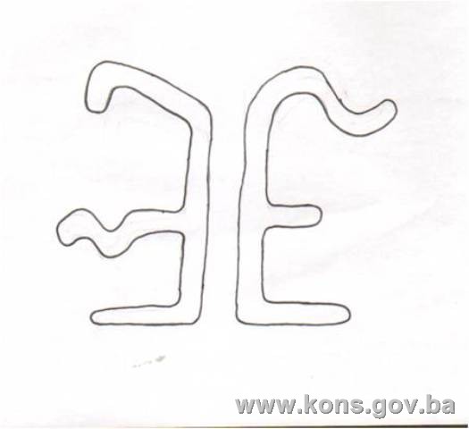
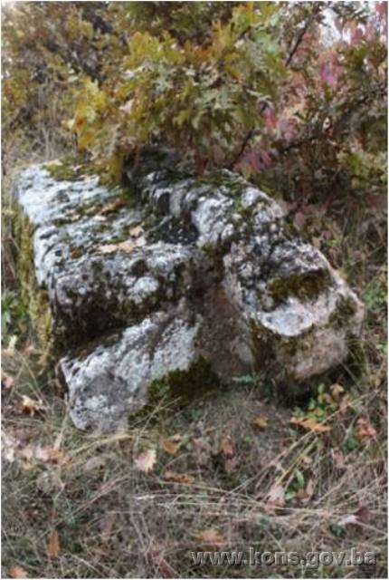
The prehistoric grave mound (tumulus) is round, with a diameter of approx. 3.5 m. and was built of stone and earth. It stands at the highest point of the site, to the north. A circle of small stones of 10 to 30 cm can be seen in places; the stone is of the same type on the entire circumference of the tumulus. The stećaks, which stand in rows from north to south, and lie west-east, belong to the type of recumbent stone monoliths: slabs, chests and gabled or sarcophagus-shaped. The artistic treatment of the stećci is to be seen in their form and decoration. Considerable aesthetic value of form was achieved – the tombstones are relatively large – but their essential artistic quality lies in their decoration, in high relief and reverse relief. The twelve tombstones consist of four slabs, two chests and six gabled, of which three are decorated: gabled no. 3, slab no. 4 and chest no. 10. The decorative motifs consists of a zigzag line, a border of vine scrolls, a double spiral, a vodenica (circular garland), a crescent moon, an “apple” (demiorb), the figure of a horseman thrusting his spear into a large dragon which is attacking a terrified woman, a dragon in a circle, a djed’s staff and a symbol that appears to consist of some kind of symmetrical spirals with handles. The stećci are of fine workmanship, some sunken into the ground or overturned.
Condition of the monuments
The prehistoric grave mound (tumulus) is round, with a diameter of about 3.5 m. and was built of stone and earth. It stands at the highest point of the site, to the north. A circle of small stones of 10 to 30 cm can be seen in places; the stone is of the same type on the entire circumference of the tumulus. The local macadam road passes the site to the east. The lower parts of the tumulus, closer to the ground, are covered with grass, while around it are low vegetation and tallish trees. Other than the stones forming a circle at the top, there are no signs of the remains of a tomb.
Stećak no. 1. – gabled with plinth, undecorated, of good workmanship, sunken at the west end, covered with moss and lichen, lying west-east; the stećak measures 127x40x40 cm; the plinth measures 60x50x14 cm.
Stećak no. 2. – gabled undecorated, of good workmanship, sunken and tilting towards the north, lying west-east; the stećak measures 104x44x35 cm.
Stećak no. 3. – gabled, decorated, covered with moss and lichen, lying west-east; the stećak measures 172x52x44 cm.
The west end is decorated with a double spiral motif in reverse relief. A double zigzag spiral, also in reverse relief, runs along the south side below the roof. The east end is decorated with a motif that could be some kind of symmetrical spirals with handles.
Stećak no. 4. – slab with plinth and decoration, covered with moss and lichen and overgrown with low-growing plants, lying west-east; the stećak measures 180x57x30 cm.
To the west the top bears a vodenica in reverse relief.
Stećak no. 5. – slab, largely sunken, covered with moss and lichen, lying west-east; the stećak measures 150x43x4 cm.
Stećak no. 6. – gabled with plinth, undecorated, covered with moss and lichen, lying west-east; the stećak measures 140x38x44 cm; the plinth measures 165x55x8cm.
Stećak no. 7. – gabled with plinth, undecorated, covered with moss and lichen and overgrown with vegetation, lying west-east; the stećak measures 175x54x53 cm; the plinth measures 194x65x2 cm.
Stećak no. 8. – slab undecorated, sunken on the north side, covered with moss and lichen, lying west-east; the stećak measures 175x68x6 cm.
Stećak no. 9. – gabled with plinth, undecorated, covered with moss and lichen and overgrown with vegetation, has slipped down a gully and is lying on its south-east side and is not therefore in situ, lying southwest-northeast; the stećak measures 161x39x81 cm; the plinth measures 200x60x30 cm.
Stećak no. 10. – chest without plinth, decorated, of good workmanship, covered with moss and lichen, overturned onto its south side, lying west-east; the stećak measures 187x70x80 cm.
The east end is decorated with what appears to be a dragon in a circle, and the west end with a crescent moon, horns pointing down, with an apple in the middle. Above the crescent moon is a cable twist border. The north end is decorated with the figure of a horseman thrusting his spear into a large dragon which is attacking a woman. The top of the stećak is decorated with a djed’s staff.
Stećak no. 11. – chest without plinth, undecorated, covered with moss and lichen and overgrown with vegetation, damaged east end, lying west-east; the stećak measures 155x104x54 cm.
Stećak no. 12. – slab without plinth, undecorated, sunken, lying north-south; the stećak measures 162x64x18 cm.
3. Legal status to date
The Regional Plan for BiH to 2000 lists 31 sites of necropolises with stećaks (1015 stećaks) in Višegrad Municipality as Category III monuments, without precise identification(11).
A letter dated 27 September 2011 from the Institute for the Protection of Monuments under the Federal Ministry of Culture and Sport states that the necropolis of stećaks in Raonići in the village of Kaoštice is not listed, but that the same village includes:
- Čaplja necropolis of stećaks, Kaoštice, Višegrad,
- Mediaeval necropolis of stećaks. 15 surviving stećaks.
The property was not on the Register of Cultural Monuments of the Socialist Republic of Bosnia and Herzegovina.
4. Research and conservation-restoration works
Research, consisting of compiling an inventory and visiting sites in Višegrad Municipality, was conducted by Šefik Bešlagić(12).
The epitaph of Juraj of Kaoštice near Međeđa has been discussed by Dr. Truhelka, Ćiro. “Bosančica, prinos bosanskoj paleografiji”. Sarajevo: Glasnik Zemaljskog Muzeja u Bosni i Hercegovini, 1889. Vol. IV, 77.; Vego, Marko. “Novi i revidirani srednjovjekovni natpisi iz Bosne.” Sarajevo: Naše starine XIV-XV, journal of the Institute for the Protection of Cultural Monuments and Natural Rarities of Bosnia and Herzegovina, 1981, 55.
No conservation-restoration works have been carried out.
5. Current condition of the property
The findings of an on-site inspection conducted on 12 November 2011 are as follows:
- the lower parts of the prehistoric grave mound (tumulus), closer to the ground, are covered with grass, while around it are low vegetation and tallish trees;
- the entire tumulus is covered with moss, where low-growing grasses are beginning to take hold;
- the tombstones are at risk of rapid deterioration as a result of neglect;
- some of the tombstones are chipped, damaged, overturned or partly or wholly sunken into the ground, and covered with plant organisms (lichen and moss);
- as plant growth resumes in spring the necropolis becomes overgrown with grass and low-growing and tall plants, causing further damage to the tombstones;
- stećak no. 9 has slid down towards the road and overturned onto its side; stećak no. 10 is also lying on its side and may be decorated on its south side as well.
6. Specific risks
- vandalism – overturning the tombstones;
- disintegration of the site as a result of long-term neglect;
- adverse effects of the elements;
- self-sown vegetation.
III – CONCLUSION
Applying the Criteria for the adoption of a decision on proclaiming an item of property a national monument (Official Gazette of BiH nos. 33/02 and 15/03), the Commission has enacted the Decision cited above.
The Decision was based on the following criteria:
A. Time frame
B. Historical value
C. Artistic and aesthetic value
C.i. quality of workmanship
C.ii. quality of materials
C.iii. proportions
C.v. value of details
D. Clarity (documentary, scientific and educational value)
D.i. material evidence of a lesser known historical era
D.iv. evidence of a certain type, style or regional manner
E. Symbolic value
E.ii. religious value
E.iii. traditional value
E.v. significance for the identity of a group of people
G. Authenticity
G.i. form and design
G.ii. material and content
G.iii. use and function
G.iv. traditions and techniques
G.v. location and setting
G.v. value of details
H. Rarity and representativity
H.i. unique or rare example of a certain type or style
The following documents form an integral part of this Decision:
- Ownership documentation
- Letter ref. 05-624-4/11 of 12 October 2011 from the Department of Spatial Planning and Communal Services of Višegrad Municipality, supplying the Commission to Preserve National Monuments with a copy of cadastral plan no. 21.15/952.1-3-234/11 of 3 October 2011 and photographs, and noting that there is no Land Register for Kaoštice cadastral municipality;
- Documentation on previous protection of the property
- Letter ref. 07-40-4-4071-1/11 dated 27 September 2011 from the Institute for the Protection of Monuments under the Federal Ministry of Culture and Sport supplying the Commission to Preserve National Monuments with details of the listing and preliminary protection status of the necropolis of stećaks in the village of Kaoštice, Višegrad Municipality;
- Letter ref. 07/1.20/624-648-1/2011 dated 28 September 2011 from the Institute for the Protection of the Cultural and Natural Heritage of Republika Srpska notifying the Commission to Preserve National Monuments that it has no information or documentation relating to the necropolis with stećak tombstones in the hamlet of Raonići in the village of Kaoštice, Višegrad Municipality.
- Photodocumentation
- Photographs of the property taken on 12 November 2011 by historian Zijad Halilović using Canon EOS 450D digital camera.
- Technical documentation
- Technical drawings of the property (plan of the necropolis, survey of the tombstones) surveyed and recorded on 12 November 2011 by Zijad Halilović, historian and archaeology specialist, and Andrew Lawler, post-graduate student at the Raymond Lemaire International Centre for Conservation, Katholieke Universiteit Leuven, Belgium, volunteer with the Commission. The plan of the necropolis, scale 1:200, was made by architect Amra Sarić, freelance associate for the technical survey of monuments for the Commission to Preserve National monuments.
Bibliography
During the procedure to designate the monument as a national monument of Bosnia and Herzegovina the following works were consulted:
1889. Dr. Truhelka, Ćiro. “Bosančica, prinos bosanskoj paleografiji” (Bosančica, contribution to Bosnian palaeography). Sarajevo: Glasnik Zemaljskog Muzeja u Bosni i Hercegovini, 1889. Vol. IV.
1971. Bejtić, Alija. “Rudo i rudski kraj kroz vijekove” (Rudo and the Rudo region over the centuries) in: Separat iz knjige «Rudo – spomenica povodom 30-godišnjice Prve proleterske brigade» (offprint from the book Rudo – commemorative volume marking the 30th anniversary of the First Proletarian Brigade). Sarajevo: 1971.
1971. Bešlagić, Šefik. Stećci, kataloško-topografski pregled (Stećci, a catalogue and topographical survey). Sarajevo: Veselin Masleša, 1971.
1980. Various authors. Prostorni plan Bosne i Hercegovine, faza b – valorizacija, prirodne i kulturno-historijske vrijednosti, Institut za arhitekturu, urbanizam i prostorno planiranje (Regional Plan for Bosnia and Herzegovina, phase B – valorization of natural, cultural and historical assets). Sarajevo: Institute for Architecture and Town and Country Planning of the Faculty of Architecture in Sarajevo and the Planning Authority of Bosnia and Herzegovina in Sarajevo, 1980.
1981. Vego, Marko. “Novi i revidirani srednjovjekovni natpisi iz Bosne” (New and revised mediaeval epitaphs and inscriptions from Bosnia). Sarajevo: Naše starine XIV, 1981.
1982. Bešlagić, Šefik. Stećci. Kultura i umjetnost (Stećak tombstones – culture and art). Sarajevo: Veselin Masleša, 1982.
1982. Šabanović, Hazim. Bosanski pašaluk, postanak i upravna podjela (Bosnian Pashaluk, origins and administrative division). Sarajevo: Svjetlost, 1982.
1988. Čović, Borivoj. “Zaspa,” in Arheološki leksikon Bosne i Hercegovine (Archaeological Lexicon of Bosnia and Herzegovina), vol. I. Sarajevo: National Museum in Sarajevo, 1988.
1988. Čović, Borivoj. “Tumulus,” in Arheološki leksikon Bosne i Hercegovine (Archaeological Lexicon of Bosnia and Herzegovina), vol. I. Sarajevo: National Museum in Sarajevo, 1988.
2003. Miškanović, Miloš D. “Karta identifikovanih naselja zemlje Pavlovića prema popisu iz 1604.” In Zemlja Pavlovića srednji vijek i period turske vladavine, Zbornik radova (Map of identified villages in the Pavlović lands according to the 1604 census, in The Pavlović lands, mediaeval and Turkish periods, collected papers) ed. Miloš D. Miškanović. Banja Luka, East Sarajevo: Academy of Sciences and Arts of Republika Srpska and University of East Sarajevo, 2003.
For more on prehistoric tumuli in Bosnia and Herzegovina see the decision of the Commission designating the group of six prehistoric grave mounds (tumuli) in Gomiljani, Municipality Trebinje as a national monument of Bosnia and Herzegovina, no. 02-2-38/2008-7 of 28 March to 1 April 2008 (Official Gazette of BiH no. 60/08) and on the Commission's web site, http://www.kons.gov.ba
Google earth, accessed on 13 November 2011
GPS Magellan Professional, accessed on 12 November 2011
(1) Google earth, accessed 13. 11. 2011.
(2) GPS Magellan professional, accessed 12. 11. 2011.
(3) Zaspa is a local term for a particular form of prehistoric tumulus in western Bosnia, increasingly now being replaced by words such as humka, unjka, crkvina, glavica etc, but preserving the tradition that they are buried churches. They are ordinary tumuli covered with earth or a mixture of earth and sand, sometimes with stone too, and are large in size, even as much as 10 m in height. They were first recorded by F. Fiala in 1896. The best known are the zaspa in Benkovac near Bosanska Krupa, Crkvina in Johovica near Bosanski Novi, Glavica (Hunjka) in Rejzović near Ključ, and Hunka in Kljevi near Sanski Most. They date roughly to the Bronze and Iron Ages (18th-3rd centuries BCE) (Borivoj Čović, “Zaspa” in Arheološki leksikon Bosne i Hercegovine, tom I, Sarajevo: Zemaljski muzej u Sarajevu, 1988, 190).
(4) Borivoj Čović, “Tumulus” in Arheološki leksikon Bosne i Hercegovine, tom I (ed. Borivoj Čović), Sarajevo: Zemaljski muzej u Sarajevu, 1988, 173.
(5) For more on prehistoric tumuli in Bosnia and Herzegovina see the decision of the Commission designating the group of six prehistoric grave mounds (tumuli) in Gomiljani, Municipality Trebinje as a national monument of Bosnia and Herzegovina, no. 02-2-38/2008-7 of 28 March to 1 April 2008 (Official Gazette of BiH no. 60/08) and on the Commission's web site, http://www.kons.gov.ba
(6) Bejtić, Alija, “Rudo i rudski kraj kroz vijekove” in Separat iz knjige «Rudo – spomenica povodom 30-godišnjice Prve proleterske brigade». Sarajevo: 1971, 185, 186.
(7) Hazim, Šabanović, Bosanski pašaluk – postanak i upravna podjela, Sarajevo: Svjetlost, 1982, 131.
(8) Marko, Vego, “Novi i revidirani srednjovjekovni natpisi iz Bosne“, Naše starine XIV-XV, Godišnjak Zavoda za zaštitu spomenika kulture prirodnih znamenitosti i rijetkosti Bosne i Hercegovine, Sarajevo: 1981, 55.
(9) Vego, Marko, “Novi i revidirani srednjovjekovni natpisi iz Bosne.” Sarajevo: Naše starine XIV-XV, Godišnjak Zavoda za zaštitu spomenika kulture prirodnih znamenitosti i rijetkosti Bosne i Hercegovine, 1981, 55.
(10) Miloš d. Miškanović, “Karta identifikovanih naselja zemlje Pavlovića prema popisu iz 1604.“, u: Zemlja Pavlovića srednji vijek i period turske vladavine, Zbornik radova (ur. Milan Vasić), Akademija nauka i umjetnosti Republike Srpske i Univerzitet Srpsko Sarajevo, Banja Luka, Srpsko Sarajevo, 2003, 2-3 i 611-613.
(11) Various authors, Prostorni plan Bosne i Hercegovine, faza b – valorizacija, prirodne i kulturno-historijske vrijednosti, Sarajevo: Institut za arhitekturu, urbanizam i prostorno planiranje Arhitektonskog fakultet u Sarajevu i Urbanistički zavod za Bosnu i Hercegovinu Sarajevo, 1980, 51.
(12) Bešlagić, Šefik, Stećci, kataloško-topografski pregled, Sarajevo: Veselin Masleša, 1971, 255-260.
|