Status of monument -> National monument
Pursuant to Article V para. 4 Annex 8 of the General Framework Agreement for Peace in Bosnia and Herzegovina and Article 39 para. 1 of the Rules of Procedure of the Commission to Preserve National Monuments, at a session held from 21 to 24 November 2011 the Commission adopted a
D E C I S I O N
I
The archaeological site of Skelani, Srebrenica Municipality, is hereby designated as a National Monument of Bosnia and Herzegovina (hereinafter: the National Monument).
The National Monument consists of a Roman settlement, two early Christian basilicas, the graves within the basilica, and movable artefacts housed in the National museum in Sarajevo and the Rimski Municipium Archaeological Museum in Skelani.
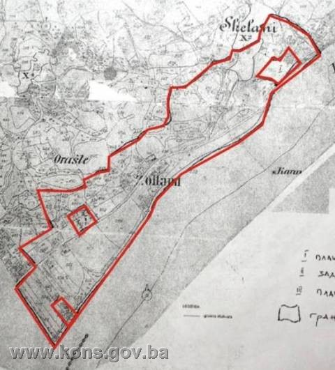
The National Monument is located on the following sites: c.p. 172/1, Land Register entry no. 2, c.p. 170/3, Land Register entry no. 125, c.p. 169/1, Land Register entry no. 3, c.p. 169/2 Land Register entry no. 33 (site of Anka’s yard), c.p. 501/1 and c.p. 501/5, Land Register entry no. 92 (site of Co-op Centre), c.p. 517/2, c.p. 517/4, c.p. 519/16 and c.p. 519/17, Land Register entry no. 120 (site of Branko’s field)c.p. 203/1, c.p. 203/2, c.p. 203/3, c.p. 203/4, c.p. 203/5, Land Register entry no. 30, c.p. 176/8, Land Register entry no. 155, c.p. 174/1, c.p. 174/3, Land Register entry no. 105, c.p. 158/5, Land Register entry no. 90, c.p. 179, c.p. 180/1, c.p. 180/2, c.p. 180/ c.p. 180/3, c.p. 180/4, c.p. 172/2, Land Register entry no. 34, c.p. 165/1, 165/2, c.p. 165/3, Land Register entry no. 128, c.p. 171, Land Register entry no.30 c.p. 159, c.p. 160, c.p. 177/1, Land Register entry no. 2, c.p. 158/2, c.p. 158/4, c.p. 158/6, Land Register entry no.84, c.p. 167/2, Land Register entry no. 57c.p. 170/1, c.p. 170/2, c.p. 168/1, c.p. 168/3, c.p. 168/4, Land Register entry no. 33, c.p. 167/1, c.p. 167/3, c.p. 167/4, Land Register entry no. 95, c.p. 161/1,c.p. 161/2, c.p. 162/2, Land Register entry no.29, c.p. 137, Land Register entry no. 2 c.p. 403, c.p. 408/1 (part), c.p. 408/2, 409/1 (part), c.p. 409/2, c.p. 409/3, c.p. 409/4, Land Register entry no.31, c.p. 175/1, c.p. 176/2, c.p. 178, c.p. 410/1, c.p. 410/3, c.p. 410/4, c.p. 176/3, c.p. 176/4, c.p. 176/5, Land Register entry no. 3, c.p. 410/5, c.p. 410/6, Land Register entry no. 149, c.p. 176/1, c.p. 176/6, c.p. 176/7, c.p. 410/2, Land Register entry no. 129, c.p. 404 (part), c.p. 405 (part), c.p. 406 (part), c.p. 407 (part), Land Register entry no.112, c.p. 411/1, c.p. 417, c.p. 417/2, c.p. 417/3, c.p. 417/4, c.p. 417/5, c.p. 420/1, c.p. 420/2, c.p. 420/3, c.p. 420/4, Land Register entry no. 5, c.p. 425, c.p. 426/3 (part), c.p. 471, c.p. 487 (part), c.p. 488, c.p. 489, c.p. 493, c.p. 426/11, c.p. 426/12, Land Register entry no. 9, c.p. 426/6, Land Register entry no.142, c.p. 426/7, Land Register entry no. 146, c.p. 426/8, Land Register entry no. 147, c.p. 426/10, Land Register entry no.150, c.p. 426/9, Land Register entry no. 148, c.p. 426/5, Land Register entry no. 143, c.p. 426/4, Land Register entry no.144, c.p. 426/2, Land Register entry no.154, c.p. 424, Land Register entry no.4, c.p. 423/3, Land Register entry no.164, c.p. 422, c.p. 423/1, c.p. 423/2, c.p. 423/4, Land Register entry no.7, c.p. 421/1, c.p. 421/2, c.p. 421/7, c.p. 421/8, c.p. 421/9, c.p. 421/10, Land Register entry no. 47, c.p. 498/2, c.p. 497/2, Land Register entry no. 71, c.p. 499/1, Land Register entry no. 118, c.p. 499/2, c.p. 499/3, c.p. 500/1, Land Register entry no. 19, c.p. 504/1, c.p. 504/3, Land Register entry no. 108, c.p. 504/2, Land Register entry no. 110, c.p. 501/7, Land Register entry no. 161, c.p. 504/4, Land Register entry no. 162, c.p. 506/1, c.p. 506/2, c.p. 506/3, c.p. 506/4, c.p. 506/5, Land Register entry no. 124, c.p. 507/1, c.p. 507/2, c.p. 507/3, c.p. 507/4, c.p. 507/5, c.p. 507/6, c.p. 508/2, c.p. 508/3, c.p. 508/4, c.p. 508/5, c.p. 508/6, c.p. 508/7, c.p. 508/8, c.p. 508/9, c.p. 509, Land Register entry no. 50, c.p. 511/1, c.p. 511/2, c.p. 511/3, c.p. 511/4, c.p. 512, Land Register entry no. 91, c.p. 513/1, c.p. 513/2, c.p. 514/1, c.p. 514/2, c.p. 514/3, Land Register entry no. 63, c.p. 515/1, c.p. 515/2, c.p. 516, Land Register entry no. 64, c.p. 517/3, c.p. 519/5, Land Register entry no.137, c.p. 517/1, c.p. 519/1, c.p. 519/2, c.p. 519/3, c.p. 519/4, c.p. 519/6, c.p. 519/7, c.p. 519/9, c.p. 519/10, c.p. 519/11, c.p. 519/12, c.p. 519/13, c.p. 519/14, c.p. 519/15, c.p. 519/18, Land Register entry no.120, c.p. 519/8, Land Register entry no. 136, c.p. 520/1, c.p. 520/2, c.p. 520/3, Land Register entry no. 104, c.p. 521, c.p. 522, Land Register entry no. 126, c.p. 461/1, c.p. 461/2, c.p. 461/3, Land Register entry no. c.p. 462, Land Register entry no. 54, c.p. 501/3, Land Register entry no.115, c.p. 497/1, c.p. 498/1, c.p. 501/4, c.p. 501/6, Land Register entry no. 92, c.p. 421/3, c.p. 421/4, c.p. 421/5, c.p. 421/6, c.p. 395, c.p. 505/1, c.p. 505/2, c.p. 505/3, c.p. 505/4, c.p. 505/5, c.p. 495/2, c.p. 495/3, c.p. 495/4, Land Register entry no. 48, c.p. 163/2, c.p. 158/1, c.p. 158/3, c.p. 174/2, c.p. 175/2, c.p. 175/3, c.p. 176/9, c.p. 177/2, c.p. 401/1, c.p. 401/2, c.p. 401/3, c.p. 402/1, c.p. 402/2, c.p. 402/3, c.p. 402/4, c.p. 411/2, c.p. 412, c.p. 413, c.p. 414/1, c.p. 414/2, c.p. 416, c.p. 420/5, c.p. 423/5, c.p. 426/1, c.p. 495/1, c.p. 495/5, c.p. 500/2, , c.p. 505/6, c.p. 506/6, c.p. 508/1, c.p. 508/10, c.p. 508/11, c.p. 508/12, c.p. 508/13, c.p. 473, cadastral municipality Žabokvica Turska, Municipality Srebrenica, Srebrenica, Republika Srpska, Bosnia and Herzegovina.
The provisions relating to protection measures set forth by the Law on the Implementation of the Decisions of the Commission to Preserve National Monuments, established pursuant to Annex 8 of the General Framework Agreement for Peace in Bosnia and Herzegovina (Official Gazette of Republika Srpska no. 9/02, 70/06 and 64/08) shall apply to the National Monument.
II
The Government of Republika Srpska shall be responsible for providing the legal, scientific, technical, administrative and financial measures necessary for the protection and presentation of the National Monument.
The Commission to Preserve National Monuments (hereinafter: the Commission) shall determine the technical requirements and secure the funds for preparing and setting up signboards with basic details of the monument and the Decision to proclaim the property a National Monument.
III
To ensure the on-going protection of the National Monument on the area defined in Clause 1 para. 3 of this Decision, the following protection zones are hereby prescribed:
Protection Zone I, consisting of c.p. 172/1, Land Register entry no. 2, c.p. 170/3, Land Register entry no. 125, c.p. 169/1, Land Register entry no. 3, c.p. 169/2, Land Register entry no. 33 (site of Anka’s yard), c.p. 501/1 and c.p. 501/5, Land Register entry no. 92, c.p. 510 (site of Co-op Centre), and c.p. 517/2, c.p. 517/4, c.p. 519/16 and c.p. 519/17 Land Register entry no. 120 (site of Branko’s field)
The following protection measures shall apply in this zone:
- all works are prohibited other than investigative and conservation-restoration works, including those designed for the presentation of the monument, with the approval of the ministry responsible for regional planning in Republika Srpska and under the expert supervision of the heritage protection authority of Republika Srpska;
- earthworks, building works and alterations to the morphology of the site, infrastructure works, and the erection of industrial facilities and plant are prohibited;
- the removal or extraction or earth, gravel or stone is prohibited;
- undercutting or undermining the gradient of the site is prohibited;
- the collection of movable archaeological artefacts with authorization is prohibited;
- leaving litter and rubbish and the temporary or permanent dumping of waste matter, hazardous chemical, explosive or toxic materials and other hazardous substances are prohibited;
- measures for the technical protection of the archaeological site may be carried out only after archaeological investigations have been conducted.
Protection Zone II, consists of c.p. 203/1, c.p. 203/2, c.p. 203/3, c.p. 203/4, c.p. 203/5, Land Register entry no. 30,c.p. 176/8, Land Register entry no. 155,c.p. 174/1, c.p. 174/3, Land Register entry no. 105, c.p. 158/5, Land Register entry no. 90, c.p. 179 , c.p. 180/1, c.p. 180/2, c.p. 180/ c.p. 180/3, c.p. 180/4, c.p. 172/2, Land Register entry no. 34, c.p. 165/1, 165/2, c.p. 165/3, Land Register entry no. 128, c.p. 171, Land Register entry no. 30, c.p. 159, c.p. 160, c.p. 177/1, Land Register entry no. 2, c.p. 158/2, c.p. 158/4, c.p. 158/6, Land Register entry no. 84, c.p. 167/2, Land Register entry no. 57;
c.p. 170/1, c.p. 170/2, c.p. 168/1, c.p. 168/3, c.p. 168/4, Land Register entry no. 33, c.p. 167/1, c.p. 167/3, c.p. 167/4, Land Register entry no. 95, c.p. 161/1, c.p. 161/2, c.p. 162/2, Land Register entry no. 29, c.p. 137, Land Register entry no. 42, c.p. 160, Land Register entry no. 2, c.p. 403 , c.p. 408/1 (part) c.p. 408/2, 409/1dio, c.p. 409/2, c.p. 409/3, c.p. 409/4, c.p., Land Register entry no. 31, c.p. 175/1, c.p. 176/2, c.p. 178, c.p. 410/1, c.p. 410/3, c.p. 410/4, c.p. 176/3, c.p. 176/4, c.p. 176/5, Land Register entry no. 3, c.p. 410/5, c.p. 410/6, Land Register entry no. 149, c.p. 176/1, c.p. 176/6, c.p. 176/7, c.p. 410/2, Land Register entry no. 129, c.p. 404 (part), c.p. 405 (part), 406 (part), c.p. 407 (part), Land Register entry no. 112, c.p. 411/1, c.p. 417, c.p. 417/2, c.p. 417/3, c.p. 417/4, c.p. 417/5, c.p. 420/1, c.p. 420/2, c.p. 420/3, c.p. 420/4, Land Register entry no. 5, c. p. 425, c.p. 426/3 (part), c.p. 471, 487 (part), c.p. 488, c.p. 489, c.p. 493, c.p. 426/11, c.p. 426/12, Land Register entry no. 9, c.p. 426/6, Land Register entry no. 142, c.p. 426/7, Land Register entry no. 146, c.p. 426/8, Land Register entry no. 147, c.p. 426/10, Land Register entry no. 150, c.p. 426/9, Land Register entry no. 148, c.p. 426/5, Land Register entry no. 143, c.p. 426/4, Land Register entry no. 144, c.p. 426/2, Land Register entry no. 154, c.p. 424, Land Register entry no. 4, c.p. 423/3, Land Register entry no. 164, c.p. 422, c.p. 423/1, c.p. 423/2, c.p. 423/4, Land Register entry no. 7, c.p. 421/1, c.p. 421/2, c.p. 421/7, c.p. 421/8, c.p. 421/9, c.p. 421/10, Land Register entry no. 47, c.p. 498/2, and c.p. 497/2, Land Register entry no. 71, c.p. 499/1, Land Register entry no. 118, c.p. 499/2, c.p. 499/3, c.p. 500/1, Land Register entry no. 19, c.p. 504/1 and c.p. 504/3, Land Register entry no. 108, c.p. 504/2, Land Register entry no. 110,c.p. 501/7, Land Register entry no. 161,c.p. 504/4, Land Register entry no. 162, c.p. 506/1, c.p. 506/2, c.p. 506/3, c.p. 506/4, c.p. 506/5, Land Register entry no. 124, c.p. 507/1, c.p. 507/2, c.p. 507/3, c.p. 507/4, c.p. 507/5, c.p. 507/6,c.p. 508/2, c.p. 508/3, c.p. 508/4, c.p. 508/5, c.p. 508/6, c.p. 508/7, c.p. 508/8, c.p. 508/9, c.p. 509, Land Register entry no. 50, c.p. 511/1, c.p. 511/2, c.p. 511/3, c.p. 511/4, c.p. 512, Land Register entry no. 91, c.p. 513/1, c.p. 513/2, c.p. 514/1, c.p. 514/2, c.p. 514/3, Land Register entry no. 63,c.p. 515/1, c.p. c.p. 515/2, c.p. 516, Land Register entry no. 64, c.p. 517/3, c.p. 519/5, Land Register entry no. 137, c.p. 517/1, c.p. 519/1, c.p. 519/2, c.p. 519/3, c.p. 519/4, c.p. 519/6, c.p. 519/7, c.p. 519/9, c.p. 519/10, c.p. 519/11, c.p. 519/12, c.p. 519/13, c.p. 519/14, c.p. 519/15, c.p. 519/18, Land Register entry no. 120, c.p. 519/8, Land Register entry no. 136, c.p. 520/1, c.p. 520/2, c.p. 520/3, Land Register entry no. 104, c.p. 521, c.p. 522, Land Register entry no. 126, c.p. 461/1, c.p. 461/2, c.p. 461/3, c.p. 462, Land Register entry no. 54, c.p. 501/3, Land Register entry no. 115, c.p. 497/1, c.p. 498/1, c.p. 501/4, c.p. 501/6, Land Register entry no. 92, c.p. 421/3, c.p. 421/4, c.p. 421/5, c.p. 421/6, c.p. 395, c.p. 505/1, c.p. 505/2, c.p. 505/3, c.p. 505/4, c.p. 505/5, c.p. 495/2, c.p. 495/3, c.p. 495/4, Land Register entry no. 48, c.p. 163/2, c.p. 158/1, c.p. 158/3, c.p. 174/2, c.p. 175/2, c.p. 175/3, c.p. 176/9, c.p. 177/2, c.p. 401/1, c.p. 401/2, c.p. 401/3, c.p. 402/1, c.p. 402/2, c.p. 402/3, c.p. 402/4,411/2, c.p. 412, c.p. 413, c.p. 414/1, c.p. 414/2, c.p. 416, c.p. 420/5, c.p. 423/5, c.p. 426/1, c.p. 495/1, c.p. 495/5, c.p. 500/2, c.p. 505/6, c.p. 506/6, c.p. 508/1, c.p. 508/10, c.p. 508/11, c.p. 508/12, c.p. 508/13 and c.p. 473.
Protection Zone II is a potential archaeological site, and in consequence all works are prohibited that could in any way have the effect of altering the site or endangering the monument without preliminary protective archaeological investigations, subject to the conditions prescribed by the heritage protection authority and suitable provision for the presentation of any finds.
IV
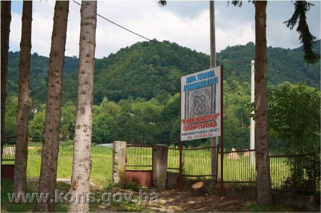
All movable artefacts found during the course of the archaeological survey shall be deposited in the Roman Municipium Archaeological Museum, Skelani, Srebrenica Municipality, catalogued, and suitably presented.
All movable archaeological artefacts found during the course of the archaeological investigations shall be professionally catalogued.
Upon completion of the archaeological works the archaeologist leading the investigations shall submit a report to the Commission and to the institution that conducted the investigations.
The archaeologist leading the investigations must have access to all the movable and immovable archaeological material found during the course of the investigations and until his/her report is completed, for a period not exceeding three years.
All immovable finds shall be conserved in situ as the archaeological investigations proceed, and the movable archaeological artefacts shall be conserved and placed for safe keeping in a suitable storage facility.
Upon receipt of the report on the investigations conducted, the Commission shall identify which movable artefacts shall be subject to protection measures to be determined by the Commission.
V
The removal of the movable artefacts referred to in Clause 4 para. 1 of this Decision (hereinafter: the movable heritage) from Bosnia and Herzegovina is prohibited.
By way of exception to the provisions of paragraph 1 of this Clause, the temporary removal from Bosnia and Herzegovina of the movable heritage for the purposes of display or conservation shall be permitted if it is established that conservation works cannot be carried out in Bosnia and Herzegovina or can be carried out to a higher standard and more quickly and cheaply abroad.
Permission for temporary removal under the conditions stipulated in the preceding paragraph shall be issued by the Commission to Preserve National Monuments, if it is determined beyond doubt that it will not jeopardize the movable heritage in any way.
In granting permission for the temporary removal of the movable heritage, the Commission shall stipulate all the conditions under which the removal from Bosnia and Herzegovina may take place, the date by which the items shall be returned to the country, and the responsibility of individual authorities and institutions for ensuring that these conditions are met, and shall notify the Government of Republika Srpska, the relevant security service, the customs authority of Bosnia and Herzegovina, and the general public accordingly.
VI
All executive and area development planning acts are hereby revoked to the extent that they are not in accordance with the provisions of this Decision.
VII
Everyone, and in particular the competent authorities of Republika Srpska and urban and municipal authorities, shall refrain from any action that might damage the National Monument or jeopardize the preservation and rehabilitation thereof.
VIII
The Government of Republika Srpska, the Ministry responsible for regional planning in Republika Srpska and the heritage protection authority of Republika Srpska, and the Municipal Authorities in charge of urban planning and land registry affairs, shall be notified of this Decision in order to carry out the measures stipulated in Articles II – VII of this Decision, and the Authorized Municipal Court shall be notified for the purposes of registration in the Land Register.
IX
The elucidation and accompanying documentation form an integral part of this Decision, which may be viewed by interested parties on the premises or by accessing the website of the Commission (http://www.kons.gov.ba)
X
Pursuant to Art. V para 4 Annex 8 of the General Framework Agreement for Peace in Bosnia and Herzegovina, decisions of the Commission are final.
XI
On the date of adoption of this Decision, the National Monument shall be deleted from the Provisional List of National Monuments of Bosnia and Herzegovina (Official Gazette of BiH no. 33/02, Official Gazette of Republika Srpska no. 79/02, Official Gazette of the Federation of BiH no. 59/02, and Official Gazette of Brčko District BiH no. 4/03), where it featured under serial no. 575.
XII
This Decision shall enter into force on the day following its publication in the Official Gazette of BiH.
This Decision has been adopted by the following members of the Commission: Zeynep Ahunbay, Martin Cherry, Amra Hadžimuhamedović, Dubravko Lovrenović, and Ljiljana Ševo.
No: 05.1-2.3-77/11-32
21 November 2011
Sarajevo
Chair of the Commission
Dubravko Lovrenović
E l u c i d a t i o n
I – INTRODUCTION
Pursuant to Article 2, paragraph 1 of the Law on the Implementation of the Decisions of the Commission to Preserve National Monuments, established pursuant to Annex 8 of the General Framework Agreement for Peace in Bosnia and Herzegovina, a “National Monument” is an item of public property proclaimed by the Commission to Preserve National Monuments to be a National Monument pursuant to Articles V and VI of Annex 8 of the General Framework Agreement for Peace in Bosnia and Herzegovina and property entered on the Provisional List of National Monuments of Bosnia and Herzegovina (Official Gazette of BiH no. 33/02) until the Commission reaches a final decision on its status, as to which there is no time limit and regardless of whether a petition for the property in question has been submitted or not.
The Commission to Preserve National Monuments issued a decision to add the site of Skelani, Srebrenica, to the Provisional List of National Monuments of Bosnia and Herzegovina under serial no. 575.
Pursuant to the provisions of the law, the Commission proceeded to carry out the procedure for reaching a final decision to designate the Property as a National Monument, pursuant to Article V of Annex 8 and Article 35 of the Rules of Procedure of the Commission to Preserve National Monuments.
Statement of Significance
The Roman town of Malvesiatium, where present-day Skelani on the Drina is now located, is one of Bosnia and Herzegovina’s most important sites of Antiquity. It was a significant economic and strategic centre dating from the reign of Emperor Vespasian (c. 70s CE). The site consists of the remains of the town hall, thermal baths, a palace, two early Christian basilicas and a brickworks, together with a quantity of important Roman monuments, including numerous inscriptions honouring local dignitaries, and an altar revealing the identity of the legions based there, some of which – such as the Legia Gemina – were among the elite troops of the Empire.
II – PRELIMINARY PROCEDURE
In the procedure preceding the adoption of a final decision to proclaim the property a national monument, the following documentation was inspected:
- Documentation on the location and current owner and user of the property (copy of cadastral plan and copy of land register entry).
- Data on the current condition and use of the property, including a description and photographs, data of war damage, data on restoration or other works on the property, etc.
- Historical, architectural and other documentary material on the property, as set out in the bibliography forming part of this Decision.
Pursuant to Article V para. 2 of Annex 8 of the General Framework Agreement for Peace in Bosnia and Herzegovina and Article 37 of the Rules of Procedure of the Commission, before rendering a final decision designating a property as a national monument, the Commission is required to provide the owner of the proposed monument, the person submitting the petition, the institutions responsible for heritage, professional and academic institutions, experts and scholars, as well as other interested parties, to express their views. Accordingly, the Commission sent the following requests:
- Letter ref. 05.1-35.2-8/11-50 dated 12 April 2011 to the Institute for the Protection of the Cultural and Natural Heritage of Republika Srpska, the Ministry of Regional Planning, Construction and the Environment of Republika Srpska and Srebrenica Municipality (department responsible for urbanism and cadastral affairs, Skelani), requesting documentation and views on the designation of the archaeological complex of Skelani, Srebrenica Municipality, as a national monument of Bosnia and Herzegovina.
- Letter ref. 05.1-36.1-7/11-108 dated 20 September 2011 to the Department of Geodetics and Proprietary Rights, Srebrenica branch, requesting documentation on the Land Register entries for the cadastral plots forming the National Monument.
- Letter ref. 05.1-35.2-8/11-200 dated 19 October 2011 to the National Museum in Sarajevo requesting information on the archaeological material from Skelani said by Karlo Patsch to have been taken to the Provincial Museum (as it was then).
- Letter ref. 05.1-36.11-/12-29 dated 14 February 2012 to the Department of Geodetics and Proprietary Rights, Srebrenica branch, requesting documentation on the Land Register entries for the archaeological complex of Skelani, Srebrenica Municipality.
In response, the Commission has received the following documentation:
- Letter ref. 07-40-4-1271-1/08 of 8 April 2008 from the Institute for the Protection of Monuments under the Federal Ministry of Culture and Sport, confirming that the property had not been protected by the Institute for the Protection of the Cultural and Natural Heritage of BiH.
- Letter ref. 082-0-RZ-12-000 dated 7 March 2012 from the Land Registry office of the Municipal Court in Srebrenica supplying the Commission with the information requested.
- In response to the above letter, the Commission sent a further request ref. 05.1-36.11-/12-43 dated 15 March 2012 to the Department of Geodetics and Proprietary Rights, Srebrenica branch, for documentation on the archaeological complex of Skelani, Srebrenica Municipality (Land Register entries for the cadastral plots not supplied under cover of letter ref. 082-0-RS-12-000 of 7 March 2012).
- The Department of Geodetics and Proprietary Rights, Srebrenica branch, replied (letter ref. 21.61/952.1-1/12 dated 21 March 2012) that on consulting the cadastral records it was found that most of the cadastral plots had previously been divided and not collated with the Land Register entries, and that it was therefore unable to “reconcile” them.
- The views of the owner had not been received at the time of adoption of this Decision.
The findings based on the review of the above documentation and the condition of the property are as follows:
1. Details of the property
Location
Skelani is on the left bank of the Drina, in the central Drina valley. Geographically, it forms the natural centre of East Osat which, together with West Osat, constitutes the microregion of Osat, with its present-day centre in Srebrenica(1).
The National Monument is located on the following sites: c.p. 172/1, Land Register entry no. 2, c.p. 170/3, Land Register entry no. 125, c.p. 169/1, Land Register entry no. 3, c.p. 169/2 Land Register entry no. 33 (site of Anka’s yard), c.p. 501/1 and c.p. 501/5, Land Register entry no. 92 (site of Co-op Centre), c.p. 517/2, c.p. 517/4, c.p. 519/16 and c.p. 519/17, Land Register entry no. 120 (site of Branko’s field), c.p. 203/1, c.p. 203/2, c.p. 203/3, c.p. 203/4, c.p. 203/5, Land Register entry no.30, c.p. 176/8, Land Register entry no. 155, c.p. 174/1, c.p. 174/3, Land Register entry no.105, c.p. 158/5, Land Register entry no. 90, c.p. 179, c.p. 180/1, c.p. 180/2, c.p. 180/ c.p. 180/3, c.p. 180/4, c.p. 172/2, Land Register entry no. 34, c.p. 165/1, 165/2, c.p. 165/3, Land Register entry no. 128, c.p. 171, Land Register entry no. 30, c.p. 159, c.p. 160, c.p. 177/1, Land Register entry no. 2, c.p. 158/2, c.p. 158/4, c.p. 158/6, Land Register entry no.84, c.p. 167/2, Land Register entry no. 57, c.p. 170/1, c.p. 170/2, c.p. 168/1, c.p. 168/3, c.p. 168/4, Land Register entry no.33, c.p. 167/1, c.p. 167/3, c.p. 167/4, Land Register entry no. 95, c.p. 161/1, c.p. 161/2, c.p. 162/2, Land Register entry no. 29, c.p. 137, Land Register entry no. 2, c.p. 403, c.p. 408/1 (part), c.p. 408/2, 409/1 (part), c.p. 409/2, c.p. 409/3, c.p. 409/4, Land Register entry no. 31, c.p. 175/1, c.p. 176/2, c.p. 178, c.p. 410/1, c.p. 410/3, c.p. 410/4, c.p. 176/3, c.p. 176/4, c.p. 176/5, Land Register entry no. 3, c.p. 410/5, c.p. 410/6, Land Register entry no. 149, c.p. 176/1, c.p. 176/6, c.p. 176/7, c.p. 410/2, Land Register entry no. 129, c.p. 404 (part), c.p. 405 (part), c.p. 406 (part), c.p. 407 (part), Land Register entry no. 112, c.p. 411/1, c.p. 417, c.p. 417/2, c.p. 417/3, c.p. 417/4, c.p. 417/5, c.p. 420/1, c.p. 420/2, c.p. 420/3, c.p. 420/4, Land Register entry no. 5, c.p. 425, c.p. 426/3 (part), c.p. 471, c.p. 487 (part), c.p. 488, c.p. 489, c.p. 493, c.p. 426/11, c.p. 426/12, Land Register entry no. 9, c.p. 426/6, Land Register entry no. 142, c.p. 426/7, Land Register entry no. 146, c.p. 426/8, Land Register entry no. 147, c.p. 426/10, Land Register entry no.150, c.p. 426/9, Land Register entry no. 148, c.p. 426/5, Land Register entry no. 143, c.p. 426/4, Land Register entry no. 144, c.p. 426/2, Land Register entry no. 154, c.p. 424, Land Register entry no. 4, c.p. 423/3, Land Register entry no. 164, c.p. 422, c.p. 423/1, c.p. 423/2, c.p. 423/4, Land Register entry no. 7, c.p. 421/1, c.p. 421/2, c.p. 421/7, c.p. 421/8, c.p. 421/9, c.p. 421/10, Land Register entry no. 47, c.p. 498/2, c.p. 497/2, Land Register entry no. 71, c.p. 499/1, Land Register entry no. 118, c.p. 499/2, c.p. 499/3, c.p. 500/1, Land Register entry no. 19, c.p. 504/1, c.p. 504/3, Land Register entry no. 108, c.p. 504/2, Land Register entry no. 110, c.p. 501/7, Land Register entry no. 161, c.p. 504/4, Land Register entry no. 162, c.p. 506/1, c.p. 506/2, c.p. 506/3, c.p. 506/4, c.p. 506/5, Land Register entry no. 124, c.p. 507/1, c.p. 507/2, c.p. 507/3, c.p. 507/4, c.p. 507/5, c.p. 507/6, .p. 508/2, c.p. 508/3, c.p. 508/4, c.p. 508/5, c.p. 508/6, c.p. 508/7, c.p. 508/8, c.p. 508/9, c.p. 509, Land Register entry no. 50, c.p. 511/1, c.p. 511/2, c.p. 511/3, c.p. 511/4, c.p. 512, Land Register entry no. 91, c.p. 513/1, c.p. 513/2, c.p. 514/1, c.p. 514/2, c.p. 514/3, Land Register entry no.63, c.p. 515/1, c.p. 515/2, c.p. 516, Land Register entry no. 64, c.p. 517/3, c.p. 519/5, Land Register entry no.137, c.p. 517/1, c.p. 519/1, c.p. 519/2, c.p. 519/3, c.p. 519/4, c.p. 519/6, c.p. 519/7, c.p. 519/9, c.p. 519/10, c.p. 519/11, c.p. 519/12, c.p. 519/13, c.p. 519/14, c.p. 519/15, c.p. 519/18, Land Register entry no. 120, c.p. 519/8, Land Register entry no. 136, c.p. 520/1, c.p. 520/2, c.p. 520/3, Land Register entry no. 104, c.p. 521, c.p. 522, Land Register entry no. 126, c.p. 461/1, c.p. 461/2, c.p. 461/3, Land Register entry no. c.p. 462, Land Register entry no. 54, c.p. 501/3, Land Register entry no. 115, c.p. 497/1, c.p. 498/1, c.p. 501/4, c.p. 501/6, Land Register entry no. 92, c.p. 421/3, c.p. 421/4, c.p. 421/5, c.p. 421/6, c.p. 395, c.p. 505/1, c.p. 505/2, c.p. 505/3, c.p. 505/4, c.p. 505/5, c.p. 495/2, c.p. 495/3, c.p. 495/4, Land Register entry no. 48, c.p. 163/2, c.p. 158/1, c.p. 158/3, c.p. 174/2, c.p. 175/2, c.p. 175/3, c.p. 176/9, c.p. 177/2, c.p. 401/1, c.p. 401/2, c.p. 401/3, c.p. 402/1, c.p. 402/2, c.p. 402/3, c.p. 402/4, c.p. 411/2, c.p. 412, c.p. 413, c.p. 414/1, c.p. 414/2, c.p. 416, c.p. 420/5, c.p. 423/5, c.p. 426/1, c.p. 495/1, c.p. 495/5, c.p. 500/2, c.p. 505/6, c.p. 506/6, c.p. 508/1, c.p. 508/10, c.p. 508/11, c.p. 508/12, c.p. 508/13, c.p. 473, cadastral municipality Žabokvica Turska, Municipality Srebrenica, Srebrenica, Republika Srpska, Bosnia and Herzegovina.
Historical background
The founding of cities was the most striking aspect of the policy of Romanization in this part of the world. In the interior regions of present-day Bosnia and Herzegovina, urbanization was at its height under the Flavians and Aelians. Domavia was a municipium prior to the reign of Trebonianus Gallus (251-253), when it first features as a colonia(2).
There were a number of other urban centres in present-day Bosnia and Herzegovina, so far identified only by site, not by name; in addition, some places mentioned in various sources were probably constituted as urban municipia with their own local government, or were sizeable settlements within these municipia. Associated with this is the status of civitatus, granted to certain municipia or coloniae or to individuals. This was a rare event prior to the Flavians (68-96) and granted only sparingly during their time, but increased in frequency during the 2nd century and up to 212 (Constitutio Antoniniana). Most of those from the local population who acquired civitas Romana did so on completion of their military service. In pre-Flavian times, most soldiers were peregrini, meaning that civitas Romana was granted only very occasionally, mainly to veterans, particularly on the grounds of individual merit. During Flavian and Trajan rule, there was a steady increase in the number of soldiers who acquired civitatus before joining the military or while actually serving. Men from the indigenous population were recruited in large numbers in the interior of the province of Dalmatia, placing in an advantageous position those who, on completion of their military service, settled in their towns and villages are citizens. Along with colonists and local tribal leaders, they formed the backbone of Roman rule.
Research to date suggests that Roman towns in present-day Bosnia and Herzegovina were modelled on those of Rome itself. This is known to some extent of Delminium, Domavia and Aquae S., as well as of Roman Stolac, Šipovo and Skelani(3). These towns had a forum, basilicas, temples, curiae, baths, piped water and other public amenities. They had a political function, as the centre of local government for a more or less extensive region, and were also, as a rule, the economic centre of a wider region or of their immediate surroundings. There were, of course, no hard-and-fast rules; rather, a range of factors, such as proximity to lines of communication, economic resources, strategic issues, a basis in the indigenous population and so on, dictated the development of Roman settlements and towns.
Mining was a major feature of the economy in the Roman province of Dalmatia. Finds from Gradina (Domavia) and environs reveal that the mining region of Srebrenica played an important part in the life of this part of the Roman Empire. Mining in this area falls into two periods: Antiquity, and the Middle Ages. The lead ore from which silver is extracted was mined here, around Domavia, and smelted in Domavia itself as well as by the mines themselves in Sase. There must have been mining activity in the Srebrenica area in prehistoric times too, as suggested by its extremely rich seams of argentiferous lead, which the Illyrians, who were skilled miners, would have had no difficulty extracting. This indicates that even in prehistoric times Domavia was a centre of some kind whose economic importance could only have been based on mining, given the lack of any other natural resources in the area(4).
The Srebrenica region, in particular along the Drina, was one of the most densely settled parts of Bosnia and Herzegovina in Roman times, and certainly the most densely populated part of the Drina valley. Research to date clearly indicates that the central Drina valley had well-laid-out urban centres as early as the late 1st century, as well as permanent garrisons. The silver mines and the area’s ease of communication with neighbouring areas favoured its development(5).
The entire municipium was characterized mainly by traditional forms of the economy, where slaves (but also liberti) played an important part, as attested by epigraphic material. Thus the basis of the economy, reliant on a river that was navigable over part of its length, was livestock-raising and agriculture, mainly on large estates: livestock-raising was probably of the extensive type. There would also have been forestry, trade and transport on the Drina, particularly of bulky goods (stone, quartzite for glass furnaces, timber, semi-manufactured mining products and so on). However, mining was also an important part of the economy, and not only before Domavia became a separate entity, though there is no confirmation of this in either historical sources or archaeological finds.
Large estates, evidently consisting of arable and pasture land and woodland (fundi, praedia), were worked by both slaves and freemen, as evidenced by such inscriptions as:
[S]eiae Fl(avii) Silvani serv(a)e,[Sc]orpus maritus(6)
Communications along the central course of the Drina covered the great bend in the river from Đurđevac to Drinjača. The Roman road, investigated by Ćiro Truhelka, has been identified over a length of about 70 km, part identified with certainty and part certainly but not firmly identified(7). The remains of Roman settlements have been found from Bratunac, where the road has been identified, to Đurđevac. Truhelka states that the road ran along the mouth of the Saska River, noting that a path along the river linked it with the mining centre of Domavia. A large hoard of 3rd century copper Roman coins minted in Viminacium was found in Sikirić, south of the confluence of the Saska and Drina rivers. Extensive remains of buildings belonging to a sizeable Roman settlement were found at Skelani(8), where the Roman road reappears, and can be traced almost without a break from Skelani to Đurđevac.
Three municipia sprang up in eastern Bosnia along the Drina: Mun. Malvesiatium, Domavia and Mun. S... to the south. Here too the process of tribal disintegration and the Romanization of the local population proceeded quite slowly, as was typical of the interior. Even so, thanks to the area’s mining resources, one of three early Vespasian municipia took shape here – the one in Skelani. All three were south of Drinjača, one with its centre in Sase near Srebrenica (Domavia), another in Skelani on the Drina (Mun. Malvesiatium) and the third further south, with its centre in Komini near Pljevlje, in the Ćehotina valley. All three spread across the Drina into what are now Serbia and Montenegro, indicating that in Antiquity the Drina did not constitute an administrative or political border.
The land north of Drinjača belonged to the western reaches of the province of Pannonia Inferior (later II Pannonia), probably with municipalities in Slavonski Brod (Marsonia) and Vinkovci (Cibalae), now in Croatia, and eastwards to the ager of the colony of Sirmium in Sremska Mitrovica(9).
Municipium Malvesiatium was in the central Drina valley, south of Domavia, with its centre in Skelani. The period when the municipium came into being can be seen from its original name, M(alvesiatiumT) muni(cipium) Fl(avium) of Rudo on the Lim, so named after the nomen gentilicium of the emperor who founded it. This places it during the first Flavian dynasty, probably during the reign of Vespasian, around the 70s CE. This is an instance in Bosnia and Herzegovina where the imperial attribute of an independent city is known. The inscriptions found there include many with the names of city magistrates (decurions and duoviri). As a result its probable territory, development and social structure are relatively well known.
Inscriptions with the names of towns or municipia are to be found on both sides of the Drina, south of Skelani and Bajina Bašta, often in abbreviated form – mun. M. . ., Ma. . . or Mal. . . – but spelled out in full as municipium Malvesiatium in Rudo, Stari Brod (damaged) and Misajlovina near Rudo(10).
A damaged inscription from Skelani naming a princeps civitatis Dinda(riorum) suggests that the territory of the Roman municipium coincided with that of the tribal Dindari civitas (civitas Dindarorum) which, with its 33 decurions, belonged to the Naronitan judicial conventus. The Dindari were an Illyrian people (indigenae) with, some scholars believe, a considerable admixture of Celtic Scordisci; other scholars, however, are more sceptical.
Epigraphic evidence from the region of Požega and Titovo Užice and from the Rudo and Višegrad area suggests that the municipium included territory on both sides of the Drina, as far as the confluence of the Lim and the Prača with the Drina. Two pieces of epigraphic evidence of the municipium, where the name of the town is abbreviated to the sigla m(unicipium) M(alvesiatium), come from Skelani itself: the first reads . . . Hviro m(unicipii) M(alvesiatium) IIv[i]ratu fu[n]cto .. . and the second . . . IIv[i]r q(uin)[q(uennalis), sa]cerd(otalis) it(em) m(unicipii) M(alvesiatium) l. p(11)
Another instance of the evidence of the municipium, this one from Stari Brod, south of Skelani, also on the left bank of the Drina, reads dec(urio) m(unicipii) Malve[siatiuml]e, while the remaining six are from the right bank of the Drina, four from the Požega and Titovo Užice area and two from the south (Rudo and Misajlovina). The inscriptions from the Rudo area give the name of the municipium in full, doubtless because Rudo was quite a long way from the municipal centre in Skelani.
It was long thought, from the distribution of this epigraphic evidence of municipium M(al...), that its centre was on the right (Serbian) side of the Drina, at Visibaba near Požega, as a result of which the area around Skelani, on the left bank, was not regarded as part of the municipium. More recent research revealed that it was a single administrative entity with its centre in Skelani, as evidenced not only by epigraphic documentation but also by analysis of the archaeological material as a whole, especially the many tombstones, attesting to a single ethnic and cultural area(12).
The material from Skelani itself includes inscriptions referring to the town council (ordo decurionum) which ran the municipium. In 158, the ordo decurionum decided to erect an honorary plinth with a statue of the emperor Antoninus Pius. Later, monuments were also erected in honour of the emperors Septimius Severus (201?) and his son Caracalla (213-217). Jus why the decurions of the town council decided to do so remains a mystery. The council (senate) also approved the site of an honorary plinth with a statue of the head of the council (primo ex ordine), the prominent citizen Titus Flavius Similis, duovir (Hviro q(uin)q(uennali), which his son T. Flavius Rufin erected in his father’s honour on 26 April 169, the natal day of the emperor Marcus Aurelius (natale Augusti).
The existence of the ordo and of a town hall (basilica) in Skelani (where the titular plinths stood) is sufficient evidence, if not proof, that this town was the seat of the municipium administration, even though it features on inscriptions in several places throughout this large municipal territory – the whole of the central Drina valley on both sides of the River Drina. These were all places where its decurions and duoviri lived and died, usually as land-owners on their own estates (villae, fundi, praedia) and as representatives of their villages (vici, pagi), coming to the town to attend sessions of the ordo decurionum(13).
Further evidence that Skelani was likely the centre of the municipium Malvesiatium is the quite large number of votive monuments erected by consular beneficiaries, who often spent time in municipal centres in their capacity as representatives of central government in the province. Yet more evidence of this is provided by a fragmentary inscription of P. Elius, head of the civitatis Dindariorum. As the only inscription preserving the ethnic name Dindari, this inscription is of evidentiary value despite its fragmented state, for if the centre of the Dindari tribe in pre-Roman times and later, at a time of peregrinus status, was in Skelani, this must have been a Roman administrative centre not only during the transitional period of the local principate but also later, after the municipium was founded.
Epigraphic evidence thus makes it quite clear that the seat of municipium M(alvesiatium) was in Skelani. What remains unclear, however, is the territorial extent of its jurisdiction, and specifically, whether the area on the right bank of the Drina, right up to the Moesian border – which formed part of the province of Dalmatia – fell within its ambit. Here too, many inscriptions of magistrates (decurions and duoviri or duumviri) have been found, with or without the name of the municipium.
The remains of the Roman settlement in Skelani give the impression of a regular urban agglomeration. Many votive and sepulchral monuments have been excavated there, along with the honorary plinths to the emperors Antoninus Pius, Septimius Severus and Caracalla. Public buildings and features include a basilica (town hall), decorated plinths and statues, and temples (a temple to the Capitoline triad, probably Silvanus and Liber, and a Mithraeum). The town also included the station of the consular beneficiaries, who were responsible for public law and order. The Roman town at Skelani was built on an area of level ground on the upper (diluvial) terrace of the Drina. Gradina, a castellieri-type fort on the hill just above Skelani, is evidence of the pre-Roman indigenous tradition(14).
The pace of Romanization of the Dindari citivas can be traced through the many inscriptions (sepulchral and votive) that have been found throughout the municipium. Since the Claudii of Skelani were eq(uites) R(omani), meaning that they belonged to the senatorial class, it may be that they were the descendants of wealthy land-owning families from Rome, as were, for example, the Catii at Ilidža near Sarajevo and in the colonia of Scupi. All the Claudii on the inscriptions date from the time when there was already a municipium at Skelani.
The earliest stratum from the indigenous (the peregrini) with Roman civitas were the Flavii, who were probably granted this status by Vespasian in the 70s CE, at much the same time as the coloniae at Siscium and Sirmium were founded. It is not impossible, however, that they were granted it by Domitian, who raised Scupi near Skopje to the rank of colonia (colonia Flavia felix Domitian); at a time of spontaneous Romanization, this was quite early. The Flavii are encountered in and around Skelani, and in the south of the municipium. T. Fl(avius) Similis and his son T. Fl. Rufinus in 169 CE are from Skelani, and Fl. Silvanus – who is probably the same as Flavius Silvanus et Severus, of somewhat later date – belonged to the same family of wealthy indigenous land-owners. A funerary monument to Seiae Fl(avii) Silvani servae was erected by her husband Scorpus, also a servus. Seia’s jewellery, like the elaborate tombstone itself, reveals that their slave peculium was no modest affair(15).
In the 2nd century, local names began to develop along Roman lines, on the tria nomina system, with the local names surviving only occasionally as a cognomen, usually of a woman: Aioia, Anna, Annia, Baeta, Bato, Catta, Dalmata, Dasius, Dussona, Genthena, Gentilla, laca, Madussa [Madus(sa)], Nindia, Pinenta, Tatta, Tattaia and Varra (Varro m.). Some cognomens, such as Lupus, Maximus, Nigrinus (?), Silvanus, Similis, Victor, Vigor and so on, were in fact none other than local names in disguise, but the most common cognomens were those that were widespread throughout the Empire (Italic, Celtic, Hispanic, Oriental and so on), reflecting the advanced Romanization of Dindari society(16).
The case of a (new) stele from Skelani erected by Can(ius) Dasa{s) in memory of his mother Ammatae (Ammat(i)sae?) is of particular interest(17). On this stele the son has an Italic gentile but an Illyrian cognomen. The onomastic formula Canius features as a cognomen, not a nomen gentilicium, on an altar erected by M. Alp(ius) Canius bf. cos. leg. I Adiut. to Jupiter, Juno and Minerva, also from Skelani. This dates from the later principate (3rd century), as does the inscription by Can-(ius) Dasa(s). Canius is not a name that has been corroborated in the capacity either of cognomen or of nomen gentilicium, in the local population.
Indigenous elements can also be discerned in religion, rather more so in the eastern than the western regions of the municipium. In and around Skelani, the dedicants are usually officials, and the dedications are usually to Jupiter, the greatest and best (IOM), powerful lord of the Roman pantheon, either alone or in company with Juno and Minerva (the Capitoline Triad), and occasionally with Mars. Dedications to the local divinities Silvanus and Liber are rare; Cl(adius) Maximus, probably a native of the area, erected an altar to the former, an unknown dedicant to the latter. The conservative nature of this society is more clearly seen in funerary practices and the art associated with them(18).
The many inscriptions in Skelani suggest that the centre of the Roman municipal administration for the eastern region of the province of Dalmatia, M(unicipium) MAL(vesiatium), was located here. This municipium was one of three urban settlements in the central and upper Drina valley in Roman times (along with Domavia near Sase and Municipium S near Pljevlje). Some inscriptions suggest that the settlement may have acquired the status of a municipium as early as Flavian times, in the latter half of the 1st century, and that it had a good many Italic settlers from the eastern Adriatic coast, as well as from other regions of the Roman Empire. This probably occurred in the first half of the 2nd century(19).
The inscriptions on altars in Skelani reveal that there were temples there dedicated to the supreme god Jupiter, the Capitoline Triad of Jupiter, Minerva and Juno, the forest god Silvanus, the god of war Mars, Liber, and the eastern god Mithras, as well as to the Greek divinities Asclepius and Hygieia, god and goddess of medicine and healing(20).
2. Description of the property
Findings of the investigations by Karlo Patsch
On 29 July 1896, Karlo Patsch carried out a field survey two km from Skelani, north-east of abandoned Karaula Liješće, on what was then the bridle path from Fakovići to Skelani. Among mediaeval tombstones of slab and sarcophagus form, in a copse belonging to Mehmed Smajlović of Liješće, he found altars, fragments of built structures and two consular beneficiaries(21).
In 1891, Ćiro Truhelka found an honorary plinth to the emperor Caracalla in Skelani itself, 750 paces north-east of the gendarmerie, “between about twenty large cut stones up to 1.3 m in height, certainly from a sizeable building, and nearby, in 1895, Ivan Kulaš found a memorial to duovir quinquennalis T. Flavius Similis, to whom, the inscription records, a statue was erected “in basilica.”(22)
In August 1896, excavations began on what was assumed to be the basilica, continuing in August and September 1897 and again for half of July 1898, when it was possible to excavate the “beneficiary station” at Karaula Liješće. However, no remains were found below the surface at either site, where mediaeval monuments had been dragged – as tombstones in the burial ground at Liješće, and as building materials for two churches at Skelani.
According to Patsch, Roman remains were found:
1. north-west of the excavations at Liješće, at Ibrahim Nekić’s Srebrena luka, with pieces of tile and lumps of plaster found on the surface of plough land, and a tile on the road to Liješće. A limestone altar, quite badly damaged but with part of an inscription still visible – l(ibens) p(osuit) – was found in a copse. During a test dig on 1 August 1898, quantities of broken round and grooved tiles and an earthenware vessel were found here;
2. at another location in Skelani, at the then “financial and gendarmerie barracks” along the Drina, south-westwards. Here, wherever foundations were dug for a building, Roman substructures and fragments of stone were found, and were used as building material for the new building(23).
There were numerous gravestones of rudimentary workmanship around Skelani. The closest quarry was at Barakovići on the Drina, above Skelani, where unfinished stećci were found, also around the church in Crvica.
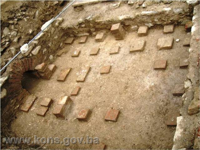
The remains of brickworks were found not far from the Drina, near basilica I. A solid, compact mass of bricks, measuring about 3.20 m in length, 2.35 m in width and 1.60 m in depth was found. Three matching channels 20 cm wide and 1.40 cm deep, set 50 cm apart, were found in the lower part of the kiln, covered with brick tiles – this was where the fire was set in the kiln. The fire pit, which was quite large, had not survived, having been destroyed by water(24).
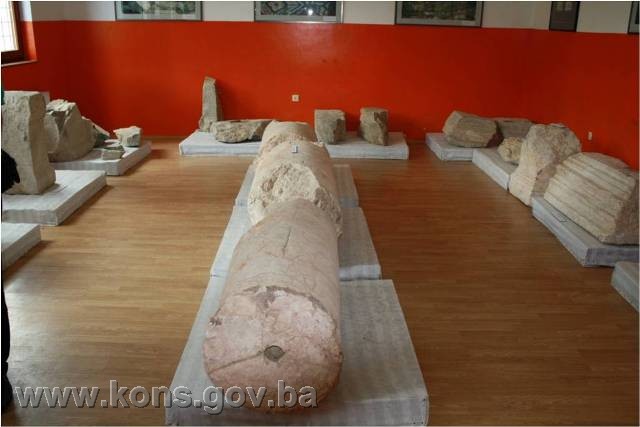
K. Patsch provided a list of stone carvings(25) found in Skelani, noting that the heavier monuments were left in covered room F of basilica I, as being too large to transport to the Provincial Museum in Sarajevo, to which the smaller fragments were taken(26).
Basilica I and basilica II
The first basilica to be found had a wealth of Roman remains and was of better construction than the second, 150 paces south-west of the first(27). The walls of the basilicas were covered by a thin layer of uncultivated soil (10 cm). Both had a single aisle with a central apse and side rooms, differing in layout and number. In both cases, most of the rooms were on the left, with just one to the right, next to the apse. The difference in layout of the basilicas could be the result of the lie of the land: the first was on a more favourable area of level ground, unlike the second.
The side rooms to the left of basilica I, the middle one of which projected out beyond the others, led one into another, but could be entered only from the forecourt, not from the basilica itself. A fairly solid wall rested on uneven foundations, of rubble stone on the inside, set in a good deal of lime plaster (without any admixture of brick). Rubble stone, hewn river stones from the Drina or spolia from Roman monuments was used for the wall face. The Roman spolia consisted of stone used whole or broken into pieces, along with broken-up pillars and statues, as material hardly fit for the purpose. Intact monuments were used mainly to reinforced the angles of parts of the basilica. Judging from the material that was found, rectangular blocks of stone and tufa were used for the upper parts of the wall. The floor was of plaster containing an admixture of crushed brick, laid over gravel. This had been broken through in places, when the basilica was later used as a burial ground. The basilica was surrounded by a contemporary burial ground, extending to the second basilica and the brick-works(28). The plan of the basilica(29) shows the skeletons found in the following rooms: room A – five skeletons (one lying north-south), room F – one skeleton, room E – two skeletons, and room G – another two skeletons. The deceased had been laid in a wooden coffin, on their backs with their heads to the east; this was true of the tombs both within and around the basilica, with the exception of the one in room A already noted. The tombs were constructed of Roman blocks and other spolia. No grave goods were found with the skeletons.
Basilica II was of simpler construction and smaller in size, befitting the different lie of the land, with an apse facing north-east. In original layout and material, it resembled basilica I, but here use had also been made of Roman tiles, hypocaust tiles and large brick tiles; mortar was used in abundance. The foundations were 55 cm deep on average. The upper walls were preserved to a height of up to 1.19 m in rooms B, C and D [translator’s note: the text is more than usually unclear here and it may be that only rooms B and C are in question]. The floor of the nave was of rammed earth, with an overlay with pieces of rubble stone only in room G (the room next to the apse). The remains of Roman walls which were observed below the basilica in rooms E, F and G appeared to spread further, but it was not possible to extend the dig into the adjoining field.
Two chance finds of Roman monuments in Skelani(30)
The first chance find from Skelani consisted part of a stone sculpture, probably representing Jupiter and the abduction of Ganymede. It was found while a sewage collection tank was being built in 1999, and discovered in a private collection in 2008. The marble fragment, measuring 60 x 25 cm, is of good quality workmanship, and consists of an unusual or even rare composition with a large bird, its back turned, and smaller, partly nude human figures of which a thigh and a small hand on the bird’s back are preserved – the whole representing the mythological story of Jupiter, the eagle and Ganymede, or possibly Leda and the swan.
The second find was of a complete altar with a dedication to Jupiter, found in 2000 during work on the Maksimović family tomb and learned of in 2003, following which it was transferred to the museum in Bijeljina(31).
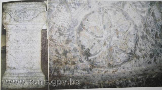
The inscription was found about 150 m from the present-day Orthodox church. Somewhat further south on the bank of the Drina is another site where the remains of two sizeable Antique buildings have been observed (part investigated in 2008, test trench 10). The altar was of hard grey-white limestone, finely finished on three sides with the fourth side left rough, probably having been up against the temple wall. It was 97.5 cm in overall height and 51.5 cm wide, with a depth of 32-36.5 cm in the upper part and 37-38 cm in the lower. The plinth was finished with five mouldings. The top of the altar bears an ornament in the form of evenly undulating tendrils from which ivy leaves hang down vertically – six to the front and on the right side, four on the left. The main ornament, in the centre of the upper part of the altar, consists of a circular rosette with six identical lobes (hemispherical segments in a circle). Level with this and to the right is a circle with an ornament of six geometrically curved arms.
The panel with the dedicatory inscription, in the central section of the altar, is 44.5 cm high and 51 cm wide. The inscription is unusually well preserved and clearly legible: I(ovi) O(ptimo) M(aximo)/M(arcus) L(ucius) VALENS CUM/m(arco) L(ucio) FRONTON/TONAE FILIO/C. I(Primae) COH(ortae) M(ilitariae)/V(otum) S(olvit) L(ibens) M(erito)(32). It is significant in that it is the earliest reference to the First Cohort (Dalmatorum) in the area(33).
Findings of the 2008 archaeological investigations at Skelani
After a gap of 112 years, archaeological investigations were again conducted in Skelani over a period of five weeks, from 8 September to 12 October 2008. The works were carried out at four sites: the Agricultural Cooperative, the churchyard of the Orthodox church, the land around the house owned by Anka Ivanović and the field owned by Branko Todorović. Machinery was used to open sixteen test pits, which later became ten trenches with an overall area of about 500 sq.m. Trenches 1, 2 and 3 were opened alongside the Agricultural Co-op, trenches 4 to 7 in the Orthodox churchyard, trenches 8 and 9 beside Anka Ivanović s house, and trench 10 in Branko Todorović’s field(34).
The first of the three original test pits in the courtyard of the Agricultural Co-op measured 9.5 x 1 m, and was in the north-east corner of the yard, at a right-angle to the south wall of the Cultural Centre. A plaster floor was found at 0.80 m, and the pit was therefore extended into Trench 1, measuring 9.50 x 5.0 m. Above the plaster floor, or mosaic, was a layer partly of soot and a layer with a scattering of plaster and fine roof-tile rubble, above which was a thicker layer of coarser mainly stone rubble. Over this again was a layer of topsoil and recent deposits.
Test pit 2 was opened in the south-eastern part of the yard, parallel with the Cultural Centre and at a right-angle to two interconnected buildings, towards the adjoining buildings of the purchasing station. Measuring 8 x 1 m, it became trench 2, measuring 7.85 x 5.50 m. Test pit 3 was opened in the north-west corner of the Co-op yard, by its south-west corner, on the assumption that mosaics had been found there in 1946 when the Centre was being built. However, it turned out that there were no archaeological strata there. Test pits 4, 5 and 6, measuring respectively 14 x 1, 8 x 1 and 8 x 1 m, were opened towards the street, at the front of the Co-op. Roman walls were found at a depth of about 50 cm, and this area thus became trench 3, measuring about 9 x 9 m.
Six test pits were opened in the churchyard of the Orthodox church, which is to the east of the high street, diagonally opposite the Co-op, in the very centre of Skelani. Test pit 7, measuring 5 x 0.50 m, opened across the road from the Roman building uncovered in the Agricultural Co-op yard, contained no archaeological strata. Test pit 8, south of the entrance to the churchyard, revealed traces of plaster and wall at a depth of 40 cm, and became trench 4, measuring 5 x 5 m. Slight traces of plaster rubble were found in test pit 9, at a depth of 0.50 m, and also in test pit 10, on a stratum with Roman provincial pottery; this area therefore became trench 5, measuring 7.50 x 4.00 m. Test pit 11, dug towards the church, by a small flight of steps, became trench 6, measuring 9 x 3 m, where there were also the remains of a wall. Earlier, when the pavement retaining wall was being built, two large dressed stones had been found, in secondary positions where they had been used as receptacles. Test pit 12, in the middle of the churchyard, became trench 7, measuring 11.50 x 3.00 m; this contained a layer with pottery artefacts.
Test pits 13 and 14 were opened at no. 62 Skelani, in Anka Ivanović’s yard. The intention was to find out whether this was the site of Basilica 1, excavated in 1897 by Karlo Patsch. Test pit 13, measuring 12 x 0.60 m, with a depth of 1.80 m, began at the tip of a dressed stone, later found to be a stećak with a hipped “roof.” Two graves were found at a depth of 1.70 m and at a distance respectively of 9 and 11.50 m from the stećak. The area around the stećak was treated as trench 8. Test pit 14, opened between the house and an outbuilding, measured 8 x 2 m. Here, a wall and a fragment of a ledge or cornice were found at a depth of 1.30 m, followed by the top of a monument, leading to the conclusion that the site had finally been identified of room F of Basilica 1 of Patsch’s 1897-1898 excavations, when the Drina flooded and covered the area with detritus. It was here that an entire treasury of 80 Roman stone monuments had been located. The archaeological excavations continued over the next two years, but all the finds were certainly now underground, and believed to have been lost in the Drina river-bed.
Test pits 15 and 16 were opened north of the entrance to the Cultural Centre of the Agricultural Co-op in Skelani village centre, in the hope of finding the north wing of the building with mosaics. However, neither pit revealed any archaeological strata.
Trench 10 was opened at Branko’s field, right on the bank of the Drina, on the southern edge of the village. Here, while working the land, the owner had found Roman walls. The area was cleared and a large area of 32 x 7 m was smoothed. At least two imposing Roman buildings were found, one of which had part of a bath-house and a well-preserved drain, while the other appeared to have had a triconch basin with hydroscopic plaster. It was only in this trench that quite large quantities of movable Roman artefacts were found(35).
The town hall, therma and palace buildings
Continuing the archaeological excavations in the Agricultural Co-op yard, trenches 1 and 2 were joined by a test pit extending between the two, allowing for the western part of the building with mosaics to be investigated down to floor level. A Roman building with mosaics was discovered in trench 3.
The grand Roman building uncovered with floor mosaics, underfloor heating and wall frescoes, covering the entire area of all three of these trenches. The only parts of the building to be identified with certainty were the north-east angle with an apse, and much of the east and part of the north exterior walls. The incompletely excavated building measuring about 25 x 18 m, and lay east-west.
The remains of this building that were excavated suggest that it was probably the most important building in the Roman settlement at Skelani, and that it was used as the town hall, or was a luxury therma or the palace of some leading figure(36).
In trench 2, the walls were preserved to an average height of 88 cm. Two small rooms were found to the south, with massive stone thresholds, 1.10 m in width and with square 7 x 7 cm holes for the door jambs. The entrance to these rooms was from the main corridor, with an entrance almost twice as large. A brick-built structure was found in the west room, a rectangular oven measuring 60 x 77 cm with a semicircular fire pit 35 cm deep and 45 cm in diameter. Traces of painted plaster with a design of vertical red and black lines on a white ground were found on the lower part of wall 1, over a length of 1.70 m and a height of 0.25 m. Similar traces of plaster were also found on wall 3 at the junction with wall 1 (40 x 20 cm). Traces of wall plaster were also found at a third point, in the south-west angle, beneath the present-day building.
Most of room F of Basilica 1 is now beneath Anka Ivanović’s house and outbuilding, and if excavations are to continue, the buildings will have to be purchased. Thirty Roman monuments were extracted from trench 9, between the two buildings.
During the course of the excavations in trenches 1, 2 and 3, beside the Agricultural Co-op, large, well-preserved Roman floor mosaics, probably dating from the first half of the 4th century(37). The mosaic was of extremely high quality, with geometric designs of four-lobed rosettes executed with a regular interlace of four circles with ornaments in dark blue and burgundy red on a contrasting white ground. These were surrounded by decorative rectangular and square panels with geometric designs and interlace, and with additional colours: light blue and ochre yellow. About 40 sq.m. of mosaics were uncovered in at least four rooms, but the central mosaic with the finest composition is expected to be in the area of the two adjoining buildings south of the Cultural Centre.
The archaeological investigations were designed to uncover the remains of architecture, so that significant movable archaeological material was found only in trench 10 and to some extent in trench 5. This was also due to the fact that when workmen were building the Agricultural Co-op in 1946 they had found the mosaics, and some unauthorized excavations were carried out by the local history teacher; none of this ever came to the knowledge of the relevant institutions(38).
List of stone carvings(39)
K-1 Part of a capital with a floral ornament, trench 3, measuring 16.5x8.5x9.5 cm
K-2 Part of a stone receptacle, trench 2 – stratum 203, measuring 30.5x23x7 cm
K-3 Fragment of a monument decorated in relief, trench 6 – stratum 602, measuring 30x22x12 cm
K-4 Fragment of a plaque with ivy-leaf decoration in relief, trench 6 – stratum 603, measuring 16x10.5x4 cm
K-5a Part of a monument with recessed panel for inscription, frame broken off (joined to 5b and 5c), trench 9 – basilica 1, visible letters P.A., measuring 30x32.5x15 cm
K-5b Part of a monument with recessed panel for inscription, frame broken off, trench 9 – basilica 1, visible letters first line DIND, second line FVNC, third line the top of the letter F, measuring 38x22x11 cm
K-5c Part of a monument with recessed panel for inscription, frame broken off, trench 9 – basilica 1, visible letters first line V and bottom of the letter F, second line RIS, third line H, measuring 33.5x19x17
K-6 Part of a monument with inscription, trench 9 – basilica 1, visible letter first line D, second line AVR:M, third line VF, measuring 29x33x11 cm
K-7 Part of a monument with inscription, trench 9 – basilica 1, visible letter O perhaps I, measuring 18x25x15 cm
K-8 Column base, trench 9 – basilica 1, measuring 27x14x12 cm
K-9 Base or capital, trench 9 – basilica 1, measuring 1.21x15x20 cm
K-10 Part of a column, trench 9 – basilica 1, measuring 1.26x21x8 cm
K-11 Part of a column, trench 9 – basilica 1, measuring 25x20x12 cm
K-12 Part of a column, trench 9 – basilica 1, measuring 14x20x12 cm
K-13 Part of a column, trench 9 – basilica 1, measuring 37x22x9 cm
K-14 Part of a column, trench 9 – basilica 1, measuring 50x22x9 cm
K-15 Part of a column, trench 9 – basilica 1, measuring 47x40x25 cm
K-16 Part of a column, trench 9 – basilica 1, measuring 27x25x9 cm
K-17 Part of a column, trench 9 – basilica 1, measuring 38x29x10 cm
K-18 Part of a column, trench 9 – basilica 1
K-19 Column base, trench 9 – basilica 1, 38x29x10 cm
K-20 Part of a monument in relief, trench 9 – basilica 1, measuring 32x26x8 cm
K-21 Part of a monument in relief, trench 9 – basilica 1, measuring 24x12x9 cm
K-22 Part of a monument in relief, trench 9 – basilica 1, measuring 22x18x5 cm
K-23 Part of a monument in relief, trench 9 – basilica 1, measuring 22x26x21 cm
K-24 Part of a monument in relief, trench 9 – basilica 1, measuring 29x25x8 cm
K-25 Part of a monument in relief, trench 9 – basilica 1, measuring 32x27x18 cm
K-26 Part of a monument in relief, trench 9 – basilica 1, measuring 22x15x9 cm
K-27 Architectural moulding, trench 9 – basilica 1, measuring 65x72x25 cm
K-28 Architectural moulding, trench 9 – basilica 1, measuring 77x80x42 cm
K-29 Architectural moulding, trench 9 – basilica 1, measuring 68x52x33 cm
K-30 Architectural moulding, trench 9 – basilica 1, measuring 49x52x33 cm
K-31 Architectural moulding, trench 9 – basilica 1, measuring 58x39x23 cm
K-32 Architectural moulding, trench 9 – basilica 1, measuring 39x42x24 cm
K-33 Architectural moulding, trench 9 – basilica 1, measuring 59x36x27 cm
K-34 Architectural moulding, trench 9 – basilica 1, measuring 79x44x20 cm
K-35 Architectural moulding, trench 9 – basilica 1, measuring 125x70x45 cm
K-36 Bipartite base (36 a and 36 b), trench 9 – basilica 1, measuring 70x56x29 cm
K-37 Bipartite base (37 a and 37 b), trench 9 – basilica 1, 55 x19 cm
K-38 Part of a column, trench 9 – basilica 1, 113x167 cm (circumference)
K-39 Part of a column, trench 9 – basilica 1, 157x180 cm (circumference)
K-40 Part of a column, trench 9 – basilica 1, 122x166 cm (circumference)
K-41a Grooved tile, Branko Todorović’s field, measuring 76x75x23 cm
K-41b Grooved tile, Branko Todorović’s field, measuring 102x79x23 cm
K-41c Grooved tile, Branko Todorović’s field, measuring 98x78x23 cm
K-42 Monument of indeterminate shape, Branko Todorović’s field, measuring 116x29x17 cm
K-43 Monument of indeterminate shape, Branko Todorović’s field, measuring 95x40x23 cm
K-44 Plaque without inscription, Branko Todorović’s field, measuring 95x40x23 cm
K-45 Altar, damaged, measuring 89X52X47 CM, with visible dedication:
LVA
SAC
LMAXIMUS
V S L M
K-46 Altar, without inscription, with rosette, measuring 89x38x28
K-47 Altar, measuring 80x36x32 cm, with dedication: IOM
K-48 Altar, damaged, measuring 104x59x45 cm, with dedication:
I O M
L NAEVIVS
MAXIMVS
B COS LEG XI
CL P F V S L M
K-49 Tombstone with figures in relief on the front and sides: front, two female figures hand-in-hand under the gable, a female figure on one side and a horseman on the other, measuring 69x58x44 cm
K-50 Monument, quite badly damaged, measuring 85x55x23 cm, with a rectangular panel containing the inscription:
D M
CL CATTAE
CLANNIA
FILIAE
DULCISSIMAE
P
K-51 Altar, damaged, consisting of two sections, measuring 80x46x30 cm. Dedication:
OVI IVNO
NI MINER
VAE M ULP
CANIUS BE
COS LEG IAD
IVT V S L M
K-52 Altar, measuring 68x54x42 cm, lower part with dedication;
- first line, visible lower part of letters V R and Q
- second line GERD I
- third line M L P
K-53 Base consisting of five sections catalogued as 531, 53b, 53c, 53d and 53e, measuring 66x35 cm, damaged, short sides moulded, and with a shallow rectangular panel with the inscription:
IMP CAES
T AEL HADR
ANTONINO AVG
PIO P P DIVI HADR
F DIVI TRAIANI PART
NEP DIVI NERVAE
PRON PONTIFIC
MAXIMO TRIBUN
POTEST XXL COS
III DECR DECVR
K-54 Part of a tufa column, Petriča, measuring 156x28x28 cm
K-55 Part of a tufa column, Petriča, measuring 133x28x28 cm
K-56 Part of a tufa column, Petriča, measuring 102x27x27 cm
K-57 Part of a tufa column, Petriča, measuring 93x29x28 cm
K-58 Part of a tufa column, Petriča, measuring 94x33x22 cm (40)
3. Legal status to date
The property is on the Provisional List of the Commission to Preserve National Monuments of Bosnia and Herzegovina under the heading Srebrenica – Skelani, Skelani, serial no. 575.
In the Regional Plan for BiH to 2000(41), basilica 2 at the site of Skelani (Drina crossing) is a protected monument under serial no 17, as Category III, with the following protection regime: no alterations to the monument or its setting; conservation works (archaeological conservation) to be carried out and the monument to be scientifically presented.
The Peoples’ Assembly of Republika Srpska adopted a Decision identifying the archaeological complex at Skelani as of outstanding significance (Official Gazette of Republika Srpska nos. 11/95 and 103/08).
4. Research and conservation-restoration works
The site at Skelani, Srebrenica, is listed in the Archaeological Lexicon of Bosnia and Herzegovina(42) as the site of a Roman settlement, two early Christian single-aisled churches, a necropolis, a mediaeval burial ground and movable artefacts.
First to publish his observations on the visible remains of Roman buildings in Skelani was the historian and researcher Felix Kanic, who described Roman monuments, parts of old streets and roads, and the remains of a palace(43).
The first archaeological investigations at Skelani were conducted between 1896 and 1898, led by Karlo Patsch, who excavated two early Christian basilicas and collected no fewer than 80 Roman stone monuments(44).
In 1891 Ćiro Truhelka found a plinth dedicated to the Emperor Caracalla.
In the autumn of 1895 J. Kulaš found a memorial to duovir quinquennalis T. Flavius Similis who, the inscription records, erected a statue “in basilica.”
Archaeological investigations at Skelani began on 1 September 2008 under archaeologist Mirko Babić, director of the Semberija Museum in Bijeljina. The investigations, which lasted for five weeks, were conducted at four sites: the Cooperative Centre, the churchyard, Branko Todorović’s field and Anka Ivanović’s yard. Thirty monuments were found, with dedications to Jupiter, the Triad, Mars, Silvanus and Mithras. The remains of Roman architecture were found in front of and behind the Co-op Centre, with 40 sq.m. of floor mosaics of a kind found nowhere else in the Balkans. A stećak measuring 205x100 cm, decorated with a bow and arrow, was also found.
5. Current condition of the property
The findings of an on-site inspection conducted on 27 June 2011 are that the soil has been replaced at all three excavated sites.
III – CONCLUSION
Applying the Criteria for the adoption of a decision on proclaiming an item of property a national monument (Official Gazette of BiH nos. 33/02 and 15/03), the Commission has enacted the Decision cited above.
The Decision was based on the following criteria:
A. Time frame
B. Historical value
C. Artistic and aesthetic value
C.i. quality of workmanship
C.ii. quality of materials
C.iii. proportions
C.iv. composition
C.v. value of details
C.vi. value of construction
D. Clarity
D.ii. evidence of historical change
D.iv. evidence of a particular type, style or regional manner
D.v. evidence of a typical way of life at a specific period
E. Symbolic value
E.i. ontological value
E.ii. religious value
E.iii. traditional value
E.iv. relation to rituals or ceremonies
E.v. significance for the identity of a group of people
F. Townscape/ Landscape value
F.i. relation to other elements of the site
F.iii. the building or group of buildings is part of a group or site
The following documents form an integral part of this Decision:
- Ownership documentation
- Copy of cadastral plan, c.m. Skelani, Srebrenica Municipality
- Copy of land register entry, c.m. SP Žabokvica-Skelani, issued by the Land Registry office of the Municipal Court in Srebrenica
- Transcript of proof of title; c.m. Skelani, issued by Srebrenica Town Council, republika Srpska, Bosnia and Herzegovina
- Photodocumentation
- Photographs taken on 27 June 2011 by archaeological Silvana Čobanov using Canon 1000D digital camera
- Drawings
Bibliography
During the procedure to designate the archaeological site of Skelani, Srebrenica Municipality, as a national monument of Bosnia and Herzegovina the following works were consulted:
1907. Patsch, Karlo. “Arheološko-epigrafska istraživanja povijesti rimske provincije Dalmacije” (Archaeological epigraphic investigations of the history of the Roman province of Dalmatia), in Glasnik Zemaljskog muzeja. Sarajevo: 1907.
1960. Pašalić, Esad. Antička naselja i komunikacije u Bosni i Hercegovini (Antique settlements and communications in BiH). Sarajevo: 1960.
1980. Redžić, Husref (ed.). Prostorni plan Bosne i Hercegovine, Faza „B“ – Valorizacija, Prirodne i kulturno-historijske vrijednosti (Regional Plan for Bosnia and Herzegovina, phase B – valorization of natural, cultural and historical assets). Sarajevo: 1980.
1988. Bojanovski, Ivo. “Bosna i Hercegovina u antičko doba” (Bosnia and Herzegovina in Antiquity), in Djela (Proceedings), Vol. LXVI. Sarajevo: Centar za balkanološka istraživanja, ANUBiH, 1988.
1988. Čović, Borivoj (ed.) Arheološki leksikon BIH (Archaeological lexicon of BiH), Vol 3. Sarajevo: 1988.
2009. Babić, Mirko. “Preliminarni izvještaj o arheološkim istraživanjima u Skelanima 2008. godine” (Preliminary report on archaeological investigations at Skelani in 2008), in Zbornik druge i treće konferencije o integrativnoj zaštiti (Papers of the 2nd and 3rd conferences on integrated protection). Banjaluka: 2009.
(1) Mirko Babić, “Preliminarni izvještaj o arheološkim istraživanjima u Skelanima 2008. godine,” in Zbornik druge i treće konferencije o integrativnoj zaštiti, Banjaluka: 2009, 171.
(2) Esad Pašalić, Antička naselja i komunikacije u Bosni i Hercegovini, Sarajevo: 1960, 86.
(3) Esad Pašalić, Op. cit, Sarajevo: 1960, 86.
(4) Esad Pašalić, Op.cit, Sarajevo: 1960, 93.
(5) Esad Pašalić, Op.cit, Sarajevo: 1960, 74.
(6) Ivo Bojanovski, “Bosna i Hercegovina u antičko doba,” in Djela, Knjiga LXVI, Sarajevo: Centar za balkanološka istraživanja, ANUBiH, 1988, 190.
(7) Esad Pašalić, Op. cit, Sarajevo: 1960, 73.
(8) Esad Pašalić, Op. cit, Sarajevo: 1960, 73.
(9) Ivo Bojanovski, Op. cit, Sarajevo: 1988, 177.
(10) Ivo Bojanovski, Op.cit, Sarajevo: 1988, 177.
(11) Ivo Bojanovski, Op.cit, Sarajevo: 1988, 177.
(12) Ivo Bojanovski, Op.cit, Sarajevo: 1988, 178.
(13) Ivo Bojanovski, Op.cit, Sarajevo: 1988, 179.
(14) Ivo Bojanovski, Op.cit, Sarajevo: 1988, 181.
(15) Ivo Bojanovski, Op.cit, Sarajevo: 1988, 182.
(16) Ivo Bojanovski, Op.cit, Sarajevo: 1988, 188.
(17) Ivo Bojanovski, Op.cit, Sarajevo: 1988, 188.
(18) Ivo Bojanovski, Op.cit, Sarajevo: 1988, 189.
(19) Mirko Babić, Op.cit, Banjaluka: 2009, 173.
(20) Mirko Babić, Op.cit, Banjaluka: 2009, 173.
(21) Karlo Patsch, “Arheološko-epigrafska istraživanja povijesti rimske provincije Dalmacije,” in Glasnik Zemaljskog muzeja, Sarajevo: 1907, 431.
(22) Karlo Patsch, Op. cit, Sarajevo: 1907, 431.
(23) “Customs officer Ivan Kulaš (now in S. Brod) and Gendarme Sergeant Ferdinand Ciganek faithfully preserved [these] old remains during their time in Skelani.” K. Patsch, Op. cit, Sarajevo: 1907, 432.
(24) Karlo Patsch, Op. cit, Sarajevo: 1907, 434.
(25) Karlo Patsch, Op. cit, Sarajevo: 1907, 435-460.
(26) Karlo Patsch, Op. cit, Sarajevo: 1907, 434.
(27) Karlo Patsch, Op. cit, Sarajevo: 1907, 460.
(28) Karlo Patsch, Op. cit, Sarajevo: 1907, 461.
(29) Karlo Patsch, Op. cit, Sarajevo: 1907, 460.
(30) Mirko Babić, Op. cit, Banja Luka: 2009, 174.
(31) Mirko Babić, Op. cit, Banja Luka: 2009, 174.
(32) In translation: To Jupiter, the best, the greatest, (dedicated by) Marcus Lucius Valens, with Marcus Frontontonus his son; officer of the First Military Cohort [who] willingly and deservedly fulfilled [his] vow. (Mirko Babić, Op. cit, Banja Luka: 2009, 175.)
(33) Mirko Babić, Op. cit, Banja Luka: 2009, 175.
(34) Mirko Babić, Op. cit, Banja Luka: 2009, 176.
(35) Mirko Babić, Op. cit, Banja Luka: 2009, 179.
(36) Mirko Babić, Op. cit, Banja Luka: 2009, 180.
(37) Mirko Babić, Op. cit, Banja Luka: 2009, 180.
(38) Mirko Babić, Op. cit, Banja Luka: 2009, 181.
(39) Published in the Official Gazette of Republika Srpska no. 38/09.
(40) According to Dragić Glišić, current director of the Skelani Roman Municipium Archaeological Museum, the stone carving was housed in the former Kosta Todorović Primary School, Crvica branch, Skelani, now the Skelani Museum.
(41) Husref Redžić (ed.), Prostorni plan Bosne i Hercegovine, Faza „B“ – Valorizacija, Prirodne i kulturno-historijske vrijednosti, Sarajevo: 1980, 41.
(42) Borivoj Čović (ed.), Arheološki leksikon BIH, Vol. 3, Sarajevo: 1988, 79.
(43) Mirko Babić, Op. cit, Banja Luka: 2009, 172. (Feliks Kanic, Srbija; zemlja i stanovništvo, parts 1 and 2, Belgrade: 1985.)
(44) Karlo Patsch, Op.cit, Sarajevo: 1907, 430.
|