Status of monument -> National monument
Pursuant to Article V para. 4 Annex 8 of the General Framework Agreement for Peace in Bosnia and Herzegovina and Article 39 para. 1 of the Rules of Procedure of the Commission to Preserve National Monuments, at a session held from 6 to 9 September 2011 the Commission adopted a
D E C I S I O N
I
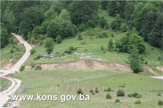
The historic site of the necropolis with stećak tombstones at Mašeti in the hamlet of Velika, Bradina, Municipality Konjic, is hereby designated as a National Monument of Bosnia and Herzegovina (hereinafter: the National Monument).
The National Monument consists of the necropolis with 78 stećak tombstones.
The National Monument is located on a site designated as cadastral plot no. 311 (part), Land Register entry no. 194, c.p. no. 330, Land Register entry no. 385, c.p. no. 328 (part), Land Register entry no. 385, c.p. no. 329 (part), Land Register entry no. 416, c.p. no. 2135 (part), Land Register entry no. 27, and c.p. no. 2136 (part), Land Register entry no. 26, cadastral municipality Bradina, Municipality Konjic, Federation of Bosnia and Herzegovina, Bosnia and Herzegovina.
The provisions relating to protection measures set forth by the Law on the Implementation of the Decisions of the Commission to Preserve National Monuments, established pursuant to Annex 8 of the General Framework Agreement for Peace in Bosnia and Herzegovina (Official Gazette of the Federation of BiH nos. 2/02, 27/02, 6/04 and 51/07) shall apply to the National Monument.
II
The Government of the Federation of Bosnia and Herzegovina (hereinafter: the Government of the Federation) shall be responsible for providing the legal, scientific, technical, administrative and financial measures necessary for the protection, conservation and presentation of the National Monument.
The Commission to Preserve National Monuments (hereinafter: the Commission) shall determine the technical requirements and secure the funds for preparing and erecting notice boards with basic details of the monument and the Decision to proclaim the property a National Monument.
III
To ensure the on-going protection of the National Monument on the site defined in Clause 1 para. 3 of this Decision, the following protection measures are hereby stipulated:
- all works are prohibited other than investigative and conservation-restoration works, routine maintenance works, and works designed to display the monument, with the approval of the Federal Ministry responsible for regional planning (hereinafter: the relevant ministry) and under the expert supervision of the heritage protection authority of the Federation of Bosnia and Herzegovina (hereinafter: the heritage protection authority);
- the site of the monument shall be open and accessible to the public, and may be used for educational and cultural purposes;
- works on the infrastructure are prohibited except with the approval of the relevant ministry and subject to the expert opinion of the heritage protection authority;
- road-widening works are prohibited;
- the necropolis may be refurbished and damage made good only subject to first drawing up a repair, restoration and conservation plan, with the approval of the relevant ministry and under the supervision of the heritage protection authority;
- lichen and moss may not be removed from the stećak tombstones;
- by way of exception to the preceding paragraph, lichen and moss may be removed from the stećaks where necessary in order to study their epigraphic or decorative elements, subject to a preliminary study and with the approval of the relevant ministry. The study shall be based on biological, chemical, physical and other analyses found by a conservator to be necessary, and shall include appropriate conservation measures and an assessment of the impact of cleaning methods on the stone;
- the zone is a potential archaeological site, and in consequence investigative works must be conducted in the presence of an archaeologist;
- the dumping of waste is prohibited.
The Government of the Federation shall be responsible in particular for ensuring that the following measures are implemented:
- a geodetic survey of the current condition of the site;
- drawing up a project for the repair, restoration, conservation and presentation of the National Monument.
The repair, restoration, conservation and presentation plan shall cover:
- archaeological investigations of the site of the National Monument;
- making good the area around stećak nos. 1 and 2;
- remedial works to the south and west sides of the necropolis to prevent soil erosion and slippage of stećak, nos. 2 and 43;
- the relocation of stećak no. 43 to within the necropolis;
- refurbishment of the necropolis and the removal of self-sown vegetation;
- routine maintenance of the National monument.
The Government of the Federation shall be responsible for ensuring that emergency protection measures are implemented to prevent further soil erosion that could cause the tombstones to shift or slide.
IV
All movable artefacts found during the course of the archaeological survey shall be deposited in the nearest museum able to provide the necessary personnel, material and technical conditions or in the National Museum of Bosnia and Herzegovina in Sarajevo, processed, and suitably presented.
All movable and immovable archaeological material found during the course of the archaeological investigations shall be professionally processed.
Upon completion of the archaeological works the archaeologist leading the investigations shall submit a report to the Commission and to the institution that conducted the investigations.
The archaeologist leading the investigations must have access to all the movable and immovable archaeological material found during the course of the investigations and until his/her report is completed, for a period not exceeding three years.
All immovable finds shall be conserved in situ as the archaeological investigations proceed, and the movable archaeological material shall be conserved and placed for safe keeping in a suitable storage facility.
Upon receipt of a report on the investigations conducted, the Commission shall identify which movable artefacts shall be subject to protection measures to be determined by the Commission.
The removal of the movable artefacts referred to in para. 1 above from Bosnia and Herzegovina is prohibited.
By way of exception to the provisions of paragraph 7 of this Clause, if the leader of the investigations determines that a given artefact must be processed abroad, and provides evidence to that effect to the Commission, the Commission may permit the temporary removal of the artefact from the country subject to detailed conditions for its export, treatment while out of the country and return to Bosnia and Herzegovina.
V
All executive and area development planning acts are hereby revoked to the extent that they are not in accordance with the provisions of this Decision.
VI
Everyone, and in particular the competent authorities of the Federation of Bosnia and Herzegovina, the Canton, and urban and municipal authorities, shall refrain from any action that might damage the National Monument or jeopardize the preservation thereof.
VII
The Government of the Federation, the Federal Ministry responsible for regional planning, the Federation heritage protection authority, and the Municipal Authorities in charge of urban planning and land registry affairs, shall be notified of this Decision in order to carry out the measures stipulated in Articles II to VI of this Decision, and the Authorized Municipal Court shall be notified for the purposes of registration in the Land Register.
VIII
The elucidation and accompanying documentation form an integral part of this Decision, which may be viewed by interested parties on the premises or by accessing the website of the Commission (http://www.kons.gov.ba).
IX
Pursuant to Art. V para 4 Annex 8 of the General Framework Agreement for Peace in Bosnia and Herzegovina, decisions of the Commission are final.
X
This Decision shall enter into force on the day following its publication in the Official Gazette of BiH.
This Decision has been adopted by the following members of the Commission: Zeynep Ahunbay, Martin Cherry, Amra Hadžimuhamedović, Dubravko Lovrenović and Ljiljana Ševo.
No: 05.2-2.3-77/11-17
6 September 2011
Sarajevo
Chair of the Commission
Ljiljana Ševo
E l u c i d a t i o n
I – INTRODUCTION
Pursuant to Article 2, paragraph 1 of the Law on the Implementation of the Decisions of the Commission to Preserve National Monuments, established pursuant to Annex 8 of the General Framework Agreement for Peace in Bosnia and Herzegovina, a “National Monument” is an item of public property proclaimed by the Commission to Preserve National Monuments to be a National Monument pursuant to Articles V and VI of Annex 8 of the General Framework Agreement for Peace in Bosnia and Herzegovina and property entered on the Provisional List of National Monuments of Bosnia and Herzegovina (Official Gazette of BiH no. 33/02) until the Commission reaches a final decision on its status, as to which there is no time limit and regardless of whether a petition for the property in question has been submitted or not.
On 22 April 2009 the Commission to Preserve National Monuments received a petition/proposal from the Department of Administrative and Social Affairs and Inspection of Konjic Municipality to designate the necropolis of stećak tombstones in the hamlet of Velika, Bradina, as a National Monument.
Pursuant to the provisions of the law, the Commission proceeded to carry out the procedure for reaching a final decision to designate the Property as a National Monument, pursuant to Article V para. 4 of Annex 8 and Article 35 of the Rules of Procedure of the Commission to Preserve National Monuments.
Statement of Significance
The mediaeval tombstones known as stećci (pl. of stećak) are unique to Bosnia and Herzegovina and its neighbours. They provide impressive evidence of the growing economic power of Bosnian feudal society in the 14th century, the opening of mines, increasing urbanization, and the wish of individuals to display their status and power through the appearance of their tombstones. The tombstones at Mašeti belong to the type of recumbent monoliths (chest-shaped and gabled or sarcophagus-like tombstones. Their number suggests that the necropolis belonged to the wider community of the area. None of the 78 tombstones is decorated.
II – PRELIMINARY PROCEDURE
In the procedure preceding the adoption of a final decision to proclaim the property a national monument, the following documentation was inspected:
- details of the current condition and use of the property, including a description, architectural survey and photographs,
- an inspection of the current condition of the property,
- a copy of the cadastral plan,
- a copy of the Land Register entry,
- historical, architectural and other documentary material on the property, as set out in the bibliography forming part of this Decision.
Pursuant to Article V para. 2 of Annex 8 of the General Framework Agreement for Peace in Bosnia and Herzegovina and Article 37 of the Rules of Procedure of the Commission, before rendering a final decision designating a property as a national monument, the Commission is required to provide the owner of the proposed monument, the person submitting the petition, the institutions responsible for heritage, professional and academic institutions, experts and scholars, as well as other interested parties, to express their views. Accordingly, the Commission sent a letter ref. 05.2-35.2-8/11-55 dated 15 April 2011 requesting documentation and views on the designation as a national monument of the necropolis with stećak tombstones at Mašeti, hamlet of Velika, Konjic Municipality, to Konjic Municipality (Mayor), department of urbanism and cadastral affairs, the Federal Ministry of Regional Planning and the Institute for the Protection of Monuments under the Federal Ministry of Culture and Sport.
In response, the Commission has received the following documentation:
- letter ref. 09-42-3-76/09 of 10 April 2009 from the Department of Administrative, Social and Inspection Affairs, Konjic Municipality, enclosing a petition, cadastral details for c.p. 330 and and Land Register entry no. 385, c.m. Bradina, Konjic;
- letter ref. 09-42-3-761/09 of 11 December 2009 from the Department of Administrative, Social and Inspection Affairs, Konjic Municipality, enclosing 14 photographs of the necropolis with stećaks in the hamlet of Velika on the Bradina to Repovci road, Konjic;
- letter ref. 09-42-3-804/09 of 15 June 2011 from the Department of Administrative, Social and Inspection Affairs, Konjic Municipality, supplying cadastral details for c.p. 311, 328,329, 2135 and 2136, and Land Register entries 194, 385, 416, 27 and 26, c.m. Bradina, Konjic;
- letter ref. 07-40-4-1261-1/11 of 4 May 2011 from the Institute for the Protection of Monuments under the Federal Ministry of Culture and Sport supplying details of previous protection of sites in the hamlet of Velika, Repovci, Konjic Municipality;
- the views of the owners of the plots had not been received at the time this Decision was rendered.
The findings based on the review of the above documentation and the condition of the site are as follows:
1. Details of the property
Location
Bradina is a village located by the Konjic to Sarajevo road, about 11 km as the crow flies northeast of Konjic Municipality [sic – presumably meaning Konjic town: Trans.]. The site known as Mašeti, with 78 stećak tombstones, is in the hamlet of Velika, by the road from Bradina to Repovci, at an altitude of 1147 m, 43º 45' 12.10" N and 17º 59' 57.68" E.
The National Monument is located on a site designated as cadastral plot no. 311 (part), Land Register entry no. 194, c.p. no. 330, Land Register entry no. 385, c.p. no. 328 (part), Land Register entry no. 385, c.p. no. 329 (part), Land Register entry no. 416, c.p. no. 2135 (part), Land Register entry no. 27, and c.p. no. 2136 (part), Land Register entry no. 26, cadastral municipality Bradina, Municipality Konjic, Federation of Bosnia and Herzegovina, Bosnia and Herzegovina.
Plot c.p. 311 is the property of Jusufbegović (Mehmeda) Nezir; plots 330, 328 and 329 are the property of R.O. Šipad Velež; and plots 2135 and 2136 are the property of Ćećez (Bogoljuba) Živko.
Historical background
In the early mediaeval period, the wider Konjic region consisted of the Neretva župa (county), part of the Zagorja župa (the area around Bjelimići) and part of the Kom župa (the area around Glavatičevo). The earliest reference to the Neretva župa is in the Chronicles of the Doclean priest(1). It lay between the župas of Rama and Kom, and according to the Chronicles, the Podgorje district also belonged to it. By the mid 11th century the župa had presumably been incorporated into the Bosnian state. From then on until ban (governor) Tvrtko came to power in 1353, it enjoyed special status within the Bosnian state(2).
From the mid 14th century on, heightened economic and political activities on the part of Bosnia's rulers can be traced in the Neretva župa. In the early 15th century the borders were redrawn between the later “Crown lands” and the feudal lands of the Kosača family. From 1404 to 1463, the Bosnian part of the Neretva župa belonged to the Crown lands and the Hum Neretva and Kom belonged to the feudal lands of the Kosača – later Herzegovina. The border between these two districts was the river Neretva, from the boundary of the Kom župa to that of the Rama župa. The area along the left bank of the Neretva belonged to the Kosačas, and that on the right bank to the Crown lands.
In the summer of 1463 an auxiliary Ottoman army conquered both the Neretva districts and Kom. The area known as Hum Neretva, apart from the Borovac fort, and the western part of the Bosnian Neretva, were liberated in a counter-action between July and September that same year by Herceg (Duke) Stjepan. The region was finally conquered in mid 1465 in a campaign by the Bosnian sanjakbey Isa-bey Ishaković in the Herceg's lands(3).
2. Description of the property
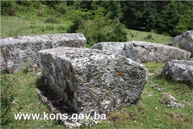
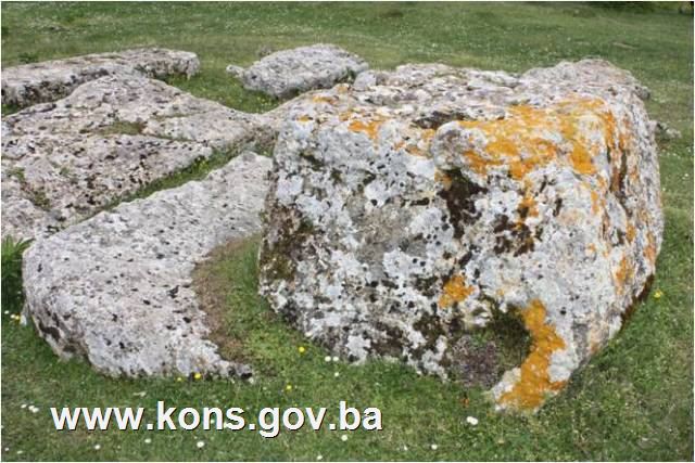
The stećci (plural of stećak) at Mašeti(4) in the hamlet of Velika are located by the Bradina to Repovci road. They belong to the type of recumbent monolith and are of two kinds: chest-shaped and gabled.
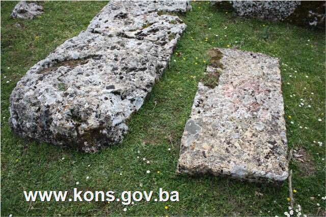
Of the total of 78 tombstones(5), two are in pieces, 37 are chest-shaped, one is a tall chest, and 38 are gabled. No decorations or epitaphs have been observed on the tombstones.
The tombstones are lying west-east and north-south, with six lying northeast-southwest and six lying northwest-southeast.
The tombstones were of good workmanship, but have suffered considerable damage, are partly buried and are covered with moss. Stećci nos. 1 and 2 were separated from the rest when the road to Repovci was widened.
Condition of the tombstones
Stećak no. 1. – gabled with plinth, located at the western end of the necropolis and separated from the main group by the road to Repovci, covered with lichen, southern part damaged, lying north-south; the stećak measures 164x63x58 cm; the plinth measures 190x85x18 cm.
Stećak no. 2. – chest, of crude workmanship, located on a small hillock at the western end of the necropolis and separated from the main group by the road to Lisin hill, lying north-south; the stećak measures 145x65x54 cm.
Stećak no. 3. – gabled with plinth, covered with lichen and moss, covered with soil on the east side, lying north-south; the stećak measures 136x65x44 cm; the plinth is 148 cm long x 18 cm high.
Stećak no. 4. – gabled with plinth, covered with moss and lichen, lying north-south; the stećak measures 188x80x70 cm; the plinth measures 190x100x15 cm.
Stećak no. 5. – gabled with plinth, partly sunken into the ground, covered with moss and lichen, lying northeast-southwest; the stećak measures 168x74x60 cm; the plinth measures 185x87x8 cm.
Stećak no. 6. – gabled with plinth, sunken to plinth level, covered with moss and lichen, lying west-east; the stećak measures 182x82x80 cm.
Stećak no. 7. – gabled with plinth, partly sunken into the ground on the east side, covered with moss and lichen, lying north-south; the stećak measures 182x80x58 cm; the plinth measures 200x95x10 cm.
Stećak no. 8. – chest, partly buried, covered with moss and lichen, overgrown with low-growing vegetation, lying west-east; the stećak measures 150x70x10 cm.
Stećak no. 9. – gabled, sunken, covered with moss and lichen, west (front) end damaged, lying west-east; the stećak measures 184x74x40 cm.
Stećak no. 10. – gabled with plinth, sunken on the north side to “roof” level, covered with moss and lichen, lying west-east; the stećak measures 158x67x46 cm; the plinth measures 180x87x19 cm.
Stećak no. 11. – gabled with plinth, sunken to plinth level, covered with lichen and moss, west (front) end damaged, lying west-east; the stećak measures 176x74x54 cm.
Stećak no. 12. – chest, partly buried, covered with lichen and moss, lying west-east; the stećak measures 208x123x33 cm.
Stećak no. 13. – gabled with plinth, partly buried on the north side and east end, covered with lichen and moss, lying west-east; the stećak measures 172x78x60 cm; the plinth measures 177x88x20 cm.
Stećak no. 14. – chest, partly buried, covered with lichen and moss, lying west-east; the stećak measures 170x77x30 cm.
Stećak no. 15. – chest, partly buried at the east end, covered with lichen and moss, lying west-east; the stećak measures 107x56x17 cm.
Stećak no. 16. – gabled with plinth, sunken to plinth level at the east end, covered with lichen and moss and overgrown with low-growing vegetation, lying west-east; the stećak measures 196x90x80 cm; the plinth measures 215x95x10 cm.
Stećak no. 17. – gabled with plinth, sunken to plinth level at the east end and with a tall tree growing at the west end, covered with lichen and moss and overgrown with low-growing vegetation, lying west-east; the stećak measures 198x90x66 cm; the plinth is 96 cm wide x 12 cm high.
Stećak no. 18. – chest, partly sunken into the ground, covered with moss and lichen, lying west-east; the stećak measures 197x89x35 cm.
Stećak no. 19. – gabled with plinth, sunken to plinth level at the east end, covered with lichen and moss, lying west-east; the stećak measures 192x88x68 cm; the plinth measures 204x105x13 cm.
Stećak no. 20. – gabled with plinth, plinth covered with topsoil, the tombstone lying on its north side, covered with moss and lichen, lying west-east; the stećak measures 188x60x90 cm; the plinth measures 204x105x13 cm.
Stećak no. 21. – gabled with plinth, sunken to plinth level, covered with moss and lichen and overgrown with low-growing vegetation, lying west-east; the stećak measures 172x84x45 cm.
Stećak no. 22. – gabled with plinth, partly buried, covered with lichen and moss, lying northeast-southwest; the stećak measures 150x66x50 cm; the plinth measures 170x85x8 cm.
Stećak no. 23. – gabled with plinth, covered with moss and lichen, lying west-east; the stećak measures 140x70x46 cm; the plinth measures 175x80x7 cm.
Stećak no. 24. – gabled with plinth, sunken to plinth level, covered with moss and lichen, lying north-south; the stećak measures 190x85x56 cm.
Stećak no. 25. – pieces of a stećak broken into four, originally lying west-east.
Stećak no. 26. – chest, partly buried, covered with lichen and moss, lying west-east; the stećak measures 120x60x14 cm.
Stećak no. 27. – chest, partly buried, covered with moss and lichen, lying west-east; the stećak measures 170x67x25 cm.
Stećak no. 28. – gabled, sunken to “roof” level, covered with lichen and moss, lying west-east; the stećak measures 190x60x24 cm.
Stećak no. 29. – chest, partly buried, covered with lichen and moss, lying west-east; the stećak measures 196x75x40 cm.
Stećak no. 30. – chest, partly buried, covered with lichen and moss, lying west-east; the stećak measures 182x68x20 cm.
Stećak no. 31. – chest, partly buried, covered with lichen and moss, lying west-east; the stećak measures 128x58x20 cm.
Stećak no. 32. – chest, partly buried, covered with lichen and moss, lying west-east; the stećak measures 186x68x17 cm.
Stećak no. 33. – chest, partly sunken into the ground, covered with lichen, lying north-south; the stećak measures 170x70x30 cm.
Stećak no. 34. – chest, partly sunken into the ground, covered with lichen, lying north-south; the stećak measures 166x65x25 cm.
Stećak no. 35. – chest, partly sunken into the ground, covered with moss and lichen, lying north-south; the stećak measures 192x82x20 cm.
Stećak no. 36. – chest, partly buried, covered with moss and lichen, lying northwest-southeast; the stećak measures 190x78x35 cm.
Stećak no. 37. – chest, partly buried, covered with moss and lichen, lying northwest-southeast; the stećak measures 172x68x30 cm.
Stećak no. 38. – gabled, partly buried, covered with lichen and moss, lying northwest-southeast; the stećak measures 180x90x38 cm.
Stećak no. 39. – gabled, partly buried, covered with lichen and moss, lying northwest-southeast; the stećak measures 170x70x38 cm.
Stećak no. 40. – gabled, partly buried, covered with lichen and moss, lying northwest-southeast; the stećak measures 190x84x44 cm.
Stećak no. 41. – gabled, partly buried, covered with lichen and moss, lying northwest-southeast; the stećak measures 176x85x40 cm.
Stećak no. 42. – chest, partly buried at the north end, covered with lichen and moss, lying north-south; the stećak measures 178x65x26 cm.
Stećak no. 43. – chest, located on the steep right-hand slope of the Bradina to Repovci road and at risk of sliding out of place, covered with lichen and moss, lying north-south; the stećak measures 115x66x27 cm.
Stećak no. 44. – chest, partly buried, southern part damaged, covered with lichen, lying north-south; the stećak measures 206x88x16 cm.
Stećak no. 45. – chest, partly buried, covered with lichen, lying north-south; the stećak measures 196x76x30 cm.
Stećak no. 46. – gabled, sunken to “roof” level, covered with moss and lichen, lying northeast-southwest; the stećak measures 192x78x20 cm.
Stećak no. 47. – chest, partly sunken into the ground, covered with moss and lichen, lying west-east; the stećak measures 200x90x16 cm.
Stećak no. 48. – chest, partly sunken into the ground, covered with moss and lichen, lying west-east; the stećak measures 194x76x20 cm.
Stećak no. 49. – chest, partly sunken into the ground, covered with moss and lichen, lying west-east; the stećak measures 148x66x20 cm.
Stećak no. 50. – chest, partly sunken into the ground, covered with moss and lichen, lying west-east; the stećak measures 177x74x26 cm.
Stećak no. 51. – gabled, part of the plinth broken off at the west end, sunken and covered with lichen, lying north-south; the stećak measures 186x87x60 cm.
Stećak no. 52. – tall chest with plinth, damaged on the north side and sunken to plinth level, covered with moss and lichen, lying west-east; the stećak measures 160x74x56 cm; the plinth measures 180x88x8 cm.
Stećak no. 53. – gabled with plinth, sunken to plinth level, covered with moss and lichen and overgrown with low-growing vegetation, lying west-east; the stećak measures 180x80x68 cm.
Stećak no. 54. – gabled, partly buried, covered with moss and lichen and overgrown with low-growing vegetation, lying west-east; the stećak measures 175x82x55 cm.
Stećak no. 55. – gabled, partly buried, covered with moss and lichen, lying west-east; the stećak measures 160x75x50 cm.
Stećak no. 56. – gabled, partly buried, north side damaged, covered with moss and lichen, lying west-east; the stećak measures 178x75x44 cm.
Stećak no. 57. – gabled, partly buried, covered with moss and lichen, lying west-east; the stećak measures 170x80x50 cm.
Stećak no. 58. – gabled with plinth, sunken to plinth level on the north side, covered with moss and lichen, lying west-east; the stećak measures 156x85x54 cm; the plinth is 160 cm long x 7 cm high.
Stećak no. 59. – gabled with plinth, sunken to plinth level on the north side, covered with moss and lichen, lying west-east; the stećak measures 192x90x68 cm; the plinth measures 200x100x16 cm.
Stećak no. 60. – gabled, partly buried and tilted to the east, covered with moss and lichen, lying northeast-southwest; the stećak measures 172x75x56 cm.
Stećak no. 61. – chest, sunken into the ground, covered with moss and lichen, lying west-east; the stećak measures 204x95x12 cm.
Stećak no. 62. – gabled, partly buried and lying on its north side, covered with moss and lichen, lying west-east; the stećak measures 174x 47(visible width)x 75 cm.
Stećak no. 63. – chest, sunken into the ground, covered with moss and lichen, lying west-east; the stećak measures 178x70x28 cm.
Stećak no. 64. – chest, sunken into the ground, covered with moss and lichen, lying west-east; the stećak measures 137x55x14 cm.
Stećak no. 65. – chest, sunken into the ground, covered with moss and lichen, lying west-east; the stećak measures 188x116x46 cm.
Stećak no. 66. – gabled with plinth, south side of plinth covered with topsoil, the tombstone is lying on its south side and is covered with moss and lichen, lying west-east; the stećak measures 180x50 (visible width)x115 cm; the plinth measures 186x117x26 cm.
Stećak no. 67. – chest, partly buried, covered with moss and lichen, lying west-east; the stećak measures 180x78x38 cm.
Stećak no. 68. – chest with plinth, sunken to plinth level at the west end, covered with lichen and moss, lying west-east; the stećak measures 120x68x30 cm; the plinth is 86 cm wide x 7 cm high.
Stećak no. 69. – gabled, partly buried, badly damaged at the east end, covered with lichen and moss, lying west-east; the stećak measures 166x70x40 cm.
Stećak no. 70. – chest, partly buried, cracked across the middle, covered with lichen and moss, lying west-east; the stećak measures 195x77x28 cm.
Stećak no. 71. – chest, partly buried, covered with lichen and moss, lying west-east; the stećak measures 125x54x17 cm.
Stećak no. 72. – chest, partly buried, covered with lichen and moss, lying west-east; the stećak measures 140x62x37 cm.
Stećak no. 73. – chest, partly buried, covered with lichen and moss, lying west-east; the stećak measures 196x90x25 cm.
Stećak no. 74. – gabled, sunken to plinth level, covered with moss and lichen, lying west-east; the stećak measures 175x76x67 cm.
Stećak no. 75. – chest, partly buried, covered with lichen and moss, lying west-east; the stećak measures 194x97x44 cm.
Stećak no. 76. – chest, sunken, covered with lichen and moss, lying northwest-southeast; the stećak measures 185x74x13 cm.
Stećak no. 77. – pieces of a stećak broken into four, originally lying northwest-southeast.
Stećak no. 78. – gabled, sunken to “roof” level, covered with moss and lichen and overgrown with low-growing vegetation at the west end, lying west-east; the stećak measures 150x62x12 cm.
3. Legal status to date
The Regional Plan for BiH to 2000 lists 69 sites of necropolises with stećak tombstones (3018 tombstones) in Konjic Municipality as Category III monuments, without precise identification(6).
Letter ref. 07-40-4-1261-1/11 of 4 May 2011 from the Institute for the Protection of Monuments of the Federal Ministry of Culture and Sport states that the property is listed as: Necropolis of stećak tombstones, Mašet, Repovci, Konjic. Mediaeval necropolis of stećak tombstones, late mediaeval
The site known as Mašeti is on the ridge between Mt. Lisina and the Velika plateau, left of the road to Bradina. 75 surviving stećak tombstones.
The property was not on the Register of Cultural Monuments of the Socialist Republic of Bosnia and Herzegovina.
4. Research and conservation-restoration works
Research works, consisting of recording and assembling data on the stećci, were conducted by Pavao Anđelić and Šefik Bešlagić and published in 1975 and 1971.
No conservation-restoration works have been carried out.
5. Current condition of the property
The findings of an on-site inspection conducted on 6 June 2011 are as follows:
- in 1964 a forest road was laid across the necropolis; the road was asphalted in 1985,
- stećak nos. 1 and 2 were separated from the necropolis when it was cut across to the west and south, which has given rise to the risk of landslide and slippage from their current positions of stećak nos. 2 and 43,
- the stećci are at risk of rapid deterioration as a result of neglect,
- some of the stećci are broken, damaged, overturned or partly or wholly sunken or buried,
- the stećci are covered with lichen and moss to a greater or lesser extent,
- the site of the necropolis becomes overgrown with grass and brambles when plant growth resumes in spring, causing further damage to the stećci.
6. Specific risks
- vandalism – overturning and smashing the stećak tombstones, and widening the Bradina to Repovci road without the presence of qualified persons;
- natural disasters – landslip following rain resulting in the tombstones sliding out of place, particularly nos. 2 and 43;
- deterioration of the site as a result of long-term neglect;
- adverse effects of the elements;
- self-sown vegetation.
III – CONCLUSION
Applying the Criteria for the adoption of a decision on proclaiming an item of property a national monument (Official Gazette of BiH nos. 33/02 and 15/03), the Commission has enacted the Decision cited above.
The Decision was based on the following criteria:
A. Time frame
B. Historical value
C. Artistic and aesthetic value
C.i. quality of workmanship
C.iii. proportions
D. Clarity
D.i. material evidence of a lesser known historical era
E. Symbolic value
E.iii. traditional value
E.v. significance for the identity of a group of people
G. Authenticity
G.i. form and design
G.ii. material and content
G.iii. use and function
G.iv. tradition and techniques
G.v. location and setting
The following documents form an integral part of this Decision:
- Ownership documentation
- Letter ref. 09-42-3-76/09 of 10 April 2009 from the Department of Administrative and Social Affairs and Inspection of Konjic Municipality supplying a petition, cadastral details for c.p. 330 and Land Register entry no. 385, c.m. Bradina, Konjic.
- Letter ref. 09-42-3-761/10 of 11 December 2010 from the Department of Administrative and Social Affairs and Inspection of Konjic Municipality supplying 14 photographs of the necropolis with stećak tombstones in the hamlet of Velika on the Bradina to Repovci road, Konjic.
- Letter ref. 09-42-3-804/09 of 15 June 2011 from the Department of Administrative and Social Affairs and Inspection of Konjic Municipality supplying cadastral details for c.p. nos. 311, 328, 329, 2135, 2136 and Land Register entries no. 194, 385, 416, 27 and 26, c.m. Bradina, Konjic.
- Documentation on previous protection of the property
- Letter ref. 07-40-4-1261-1/11 of 4 May 2011 from the Institute for the Protection of Monuments of the Federal Ministry of Culture and Sport supplying details of previous protection of the site in the hamlet of Velika, Repovci, Municipality Konjic.
- Photodocumentation:
- Photographs of the property taken on 6 June 2011 by historian Zijad Halilović using Canon EOS 450D digital camera.
- Technical documentation
- Technical drawings of the state of the property (plan of the necropolis, survey of the monuments), measured and surveyed on 6 June 2011 by historian Zijad Halilović and architect Nermina Katkić.
Bibliography
During the procedure to designate the property as a national monument of Bosnia and Herzegovina the following works were consulted:
1971. Bešlagić, Šefik. Stećci, kataloško-topografski pregled (Stećci, a catalogue and topographical survey). Sarajevo: Veselin Masleša, 1971, 325.
1975. Anđelić, Pavao. Historijski spomenici Konjica i okoline (Historic Monuments of Konjic and its Environs), I. Konjic: Konjic Council, 1975, 199.
1980. Various authors. Prostorni plan Bosne i Hercegovine, faza b – valorizacija, prirodne i kulturno-historijske vrijednosti (Regional Plan for Bosnia and Herzegovina, phase B – valorization of natural and cultural assets). Sarajevo: Institute for Architecture, Urbanism and Spatial Planning of the Faculty of Architecture in Sarajevo and the Planning Authority for Bosnia and Herzegovina, Sarajevo, 1980, 51.
1982. Anđelić, Pavao. “Politička organizacija župe Neretve i njezino mjesto u širim političkim okvirima” (Territorial and political organization of the Neretva County and its place in the broader political context), In: Studije o teritorijalnopolitičkoj organizaciji srednjovjekovne Bosne (Studies on the territorial and political organization of mediaeval Bosnia). Sarajevo: Svjetlost, 1982, 108-110.
1982. Bešlagić, Šefik. Stećci. Kultura i umjetnost (Stećak tombstones – culture and art). Sarajevo: Veselin Masleša, 1982.
http://www.historiografija.hr/prikazi.php?id=235953
(1) On 3 March 2011 the History Department of the Faculty of the Humanities, University of Zagreb, held an international seminar, “The Chronicles of the Doclean Priest and the challenges of recent historiography,” at which Tibor Živković gave a paper entitled “Odnos hrvatske i latinske redakcije Gesta regnum Sclavorum,” analyzing both redactions of the Chronicles – the “Croatian redaction,” originally composed in Latin, and the “Latin redaction,” and their interrelationship. A narrative-based analysis of the two redactions revealed that both were composed by the same person, suggesting that the Croatian redaction was the original and the Latin redaction the final version of the Chronicles. The paper has not yet been published. From http://www.historiografija.hr/prikazi.php?id=235953, accessed 17 October 2011.
(2) Anđelić, Dr. Pavao, “Teritorijalnopolitička organizacija srednjovjekovne župe Neretve i njezino mjesto u širim političkim okvirima,” in Studije o teritorijalnopolitičkoj organizaciji srednjovjekovne Bosne, Sarajevo, 1982, 108-110.
(3) Anđelić, Dr. Pavao, op.cit.,Sarajevo, 1982, 110, 115-156.
(4) There are various interpretations of this term. For instance, Ćiro Truhelka was of the view that the name mašet derived from the Turkish meșhed (Arabic mashhad), a monument to a hero killed fighting for the faith. Both Šefik Bešlagić and Vejsli Ćurčić believe it to be of Italian origin, after the Italian masseto meaning a large stone, a term often used in the western regions influenced by Italian. (Bešlagić, Šefik. Stećci-kultura i umjetnost, Sarajevo: IRO Veselin Masleša, 1982, 33.)
(5) Š. Bešlagić and P. Anđelić give details of 75 stećak tombstones – 37 chests and 38 gabled. (Bešlagić, Šefik, Stećci, kataloško-topografski pregled, Sarajevo: "Veselin Masleša", 1971, 325; Anđelić, Pavao, Historijski spomenici Konjica i okoline, Konjic: Skupština opštine Konjic, 1975, 199.).
(6) Various authors, Prostorni plan Bosne i Hercegovine, faza b – valorizacija, prirodne i kulturno-historijske vrijednosti, Sarajevo: Institute for Architecture, Urbanism and Spatial Planning of the Faculty of Architecture in Sarajevo and the Planning Authority for Bosnia and Herzegovina, Sarajevo, 1980, 52.
|