Status of monument -> National monument
Published
in the “Official Gazette of BiH”, no. 24/10.
Pursuant
to Article V para. 4 Annex 8 of the General Framework Agreement for Peace in Bosnia and Herzegovina
and Article 39 para. 1 of the Rules of Procedure of the Commission to Preserve
National Monuments, at a session held from 8 to 11 September 2009 the
Commission adopted a
D E C I S
I O N
I
The
cultural landscape of the Blatačko lake with part of the Rakitnica gorge,
prehistoric grave mounds and necropolises with stećak and nišan tombstones in
the village of Blace, Konjic Municipality, is hereby designated as
a National Monument of Bosnia and Herzegovina (hereinafter: the National
Monument).
The
National Monument consists of:
a) the
Blatačko lake and its surrounding landscape with an area of 20 hectares and
part of the Rakitnica gorge,
b) four
prehistoric grave mounds and a necropolis with 15 stećak tombstones at
Kosan-krst,
c) a
prehistoric grave mound and a necropolis with 12 stećak tombstones at Viš
stijena,
d) a
prehistoric grave mound and a necropolis with three stećak tombstones at
Babaluša,
e) a
necropolis with eight stećak tombstones at Kod Čekića,
f) a
prehistoric grave mound and an isolated stećak at Komadinov do,
g) a
necropolis with seven stećak tombstones in an Orthodox cemetery in active use,
h) a
necropolis with nine nišan tombstones near Komadinov do,
The
National Monument is located on a site designated as cadastral plot no. 1348
(part), 2653, 2655, Land Register entry no. 312, c.p. no. 2633, Land Register
entry no. 348, c.p. no. 2670, Land Register entry no. 123, c.p. no. 2878/1,
Land Register entry no. 261, and c.p. no. 2955, Land Register entry no. 264, cadastral
municipality Čuhovići, Municipality Konjic, Federation of Bosnia and
Herzegovina, Bosnia and Herzegovina.
The
provisions relating to protection measures set forth by the Law on the
Implementation of the Decisions of the Commission to Preserve National
Monuments, established pursuant to Annex 8 of the General Framework Agreement
for Peace in Bosnia and Herzegovina (Official Gazette of the Federation of BiH
nos. 2/02, 27/02, 6/04 and 51/07) shall apply to the National Monument.
II
The
Government of the Federation of Bosnia and Herzegovina (hereinafter: the
Government of the Federation) shall be responsible for providing the legal,
scientific, technical, administrative and financial measures necessary for the
protection, conservation and presentation of the National Monument.
The
Commission to Preserve National Monuments (hereinafter: the Commission) shall
determine the technical requirements and secure the funds for preparing and
erecting signboards with basic details of the monument and the Decision to
proclaim the property a National Monument.
III
To ensure
the on-going protection of the National Monument on the site defined in Clause
1 para. 3 of this Decision, the following protection measures shall
apply:
-
all works are prohibited
other than investigate and conservation-restoration works, including works
designed to display the National Monument, with the approval of the Federal
Ministry responsible for regional planning (hereinafter: the relevant ministry)
and under the expert supervision of the heritage protection authority of the
Federation of Bosnia and Herzegovina (hereinafter: the heritage protection
authority);
-
the removal of the
tombstones from the graves to any other location is prohibited unless the
Commission shall decide otherwise and define the conditions for the relocation
of the tombstones;
-
the site of the monument
shall be open and accessible to the public, and may be used for educational and
cultural purposes;
-
infrastructure works shall
be permitted only with the approval of the relevant ministry and subject to the
expert opinion of the heritage protection authority;
-
the dumping of waste is
prohibited;
-
the area is a potential
archaeological site, and an archaeologist must therefore be present during
investigative works of any kind.
The
Government of the Federation shall be responsible in particular for drawing up
a project for the repair, restoration and conservation of the
necropolises with stećak and nišan tombstones, to cover:
-
systematic archaeological
investigations of the site;
-
clearing away lichens and moss
and making good any damage;
-
tidying the necropolises
and removing self-sown vegetation;
-
providing access to the
site, making good an access road and footpaths to every part of the site;
-
conservation of any
remains found;
-
drawing up and
implementing a programme for the presentation of the National Monument.
The
following protection measures are hereby prescribed for the natural
heritage:
-
picking and collecting the
following plant species are prohibited (except for the collection of seeds for
conservation purposes):
-
Sesleria juncifolia
-
Sesleria coerulens
-
Festuca panciciana
-
Festuca bosniaca
-
Senecio bosniacus
-
Veronica satureoides
-
Gentiana dinarica
-
Gentiana symphyandra
-
Gentianella crispata
-
Endraianthus
serpyllifolius
-
Saxifraga caryophylla
-
Minuartia clandestina
-
Silene pusilla
-
Alchemilla velebitica
-
Cerastium dinaricum
To
protect the natural and historic site without impairing the existing ecological
balance, and to protect the natural heritage, a buffer zone is hereby
stipulated which shall follow the boundaries specified in the Decision
designating Mt Igman, Bjelašnica, Treskavica and the Rakitnica gorge (Visočica)
as a site of special interest to the Federation of Bosnia and Herzegovina
(Official Gazette of the Federation of BiH no. 8/05). The following protection
measures shall apply in this zone.
-
the quarrying of stone,
tree-felling (with the exception of felling for the maintenance of forest
health and vitality), the construction of industrial facilities and major
infrastructure and of any properties or facilities that during construction or
operation could pose a threat to the National Monument;
-
(potential) environmental
polluters as defined by law shall be identified and rectified, and a plan shall
be drawn up for the management of waste, waste waters, the environment and
natural resources.
In
addition to the above protection measures, the measures prescribed in the
Decision designating Mt Igman, Bjelašnica, Treskavica and the Rakitnica gorge
(Visočica) as a site of special interest to the Federation of Bosnia and Herzegovina
shall also apply in the buffer zone.
IV
All
movable artefacts found during the course of archaeological investigations
shall be deposited in the nearest museum or in the National Museum of Bosnia
and Herzegovina in Sarajevo,
processed, and suitably presented.
The
removal of the movable artefacts from Bosnia and Herzegovina is
prohibited. By way of exception to the provisions of paragraph 2 of this
Clause, the temporary removal from Bosnia and Herzegovina of the movable
artefacts for the purposes of display or conservation shall be permitted if the
leader of the investigations determines that a given artefact must be processed
abroad, and provides evidence to that effect to the Commission, which may
permit the temporary removal of the artefact from the country subject to
detailed conditions for its export, treatment while out of the country and
return to Bosnia and Herzegovina.
Upon
receipt of a report on the investigations conducted, the Commission shall identify
which movable artefacts shall be subject to protection measures to be
determined by the Commission.
V
All
executive and area development planning acts are hereby revoked to the extent
that they are not in accordance with the provisions of this Decision.
VI
Everyone,
and in particular the competent authorities of the Federation of Bosnia and
Herzegovina, the Canton, and urban and municipal authorities, shall refrain
from any action that might damage the National Monument or jeopardize the
preservation thereof.
VII
The
Government of the Federation, the Federal Ministry responsible for regional
planning, the Federation heritage protection authority, and the Municipal
Authorities in charge of urban planning and land registry affairs, shall be
notified of this Decision in order to carry out the measures stipulated in
Articles II to VI of this Decision, and the Authorized Municipal Court shall be
notified for the purposes of registration in the Land Register.
VIII
The
elucidation and accompanying documentation form an integral part of this
Decision, which may be viewed by interested parties on the premises or by
accessing the website of the Commission (http://www.aneks8komisija.com.ba)
IX
Pursuant
to Art. V para 4 Annex 8 of the General Framework Agreement for Peace in Bosnia and Herzegovina,
decisions of the Commission are final.
X
This
Decision shall enter into force on the day following its publication in the
Official Gazette of BiH.
This
Decision has been adopted by the following members of the Commission: Zeynep
Ahunbay, Martin Cherry, Amra Hadžimuhamedović, Dubravko Lovrenović, and
Ljiljana Ševo.
No. 02-2-40/09-52
9 September 2009
Sarajevo
Chair of
the Commission
Amra
Hadžimuhamedović
E l u c i
d a t i o n
I – INTRODUCTION
Pursuant
to Article 2, paragraph 1 of the Law on the Implementation of the Decisions of
the Commission to Preserve National Monuments, established pursuant to Annex 8
of the General Framework Agreement for Peace in Bosnia and Herzegovina, a
“National Monument” is an item of public property proclaimed by the Commission
to Preserve National Monuments to be a National Monument pursuant to Articles V
and VI of Annex 8 of the General Framework Agreement for Peace in Bosnia and
Herzegovina and property entered on the Provisional List of National Monuments
of Bosnia and Herzegovina (Official Gazette of BiH no. 33/02) until the
Commission reaches a final decision on its status, as to which there is no time
limit and regardless of whether a petition for the property in question has
been submitted or not.
On 2
March 2007 the Department of Administrative, Social and Inspectorate Affairs of
Konjic Municipality submitted to the Commission a petition/proposal to designate
the necropolis of stećak tombstones in the village
of Blace as a national monument of Bosnia
and Herzegovina.
On 13
November 2008 the Department of Administrative, Social and Inspectorate Affairs
of Konjic Municipality submitted to the Commission a petition/proposal to
designate the natural and historic area of the necropolis of stećak tombstones
and the Blatačko Lake
as a national monument
of Bosnia and Herzegovina.
Pursuant
to the provisions of the law, the Commission proceeded to carry out the procedure
for reaching a final decision to designate the Property as a National Monument,
pursuant to Article V para. 4 of Annex 8 and Article 35 of the Rules of
Procedure of the Commission to Preserve National Monuments.
Statement of Significance
The cultural
landscape of the Blatačko
Lake is on Mt Bjelašnica,
on the boundary with Mt Visočica, with between them the Rakitnica gorge, in a
landscape of outstanding beauty and a high degree of biodiversity of both flora
and fauna.
The
National Monument also includes 44 stećak tombstones, two cruciform tombstones
and nine nišan tombstones at seven sites in the village of Blace.
The mediaeval tombstones known as stećci (pl. of stećak) are
unique to Bosnia and
Herzegovina and its neighbours. They provide
impressive evidence of the growing economic power of Bosnian feudal society in
the 14th century, the opening of mines, increasing urbanization, and the wish
of individuals to display their status and power through the appearance of
their tombstones. The number of tombstones on these sites, in the centre of an
inhabited area, attests to the density of population and economic power of the
mediaeval inhabitants of the area. The settlement continued to be inhabited in
the early Ottoman period, as evidenced by nišan tombstones dating from the 16th
century. The tombstones at these sites were made of local stone, and are
slab-shaped, chest-shaped, gabled (sarcophagus-like) or cruciform. Some are
decorated with realistic and symbolic designs (demi-orb, rosette, circle, rope twist,
friezes of spirals and scrolling vines, a Greek cross with the arms terminating
in volutes, crescent moon, cudgel, and sword and shield).
II – PROCEDURE PRIOR TO DECISION
In the
procedure preceding the adoption of a final decision to proclaim the property a
national monument, the following documentation was inspected:
-
Documentation on the
location and the current owner and user of the property (copy of cadastral plan
and Land Register entry).
-
Details of the current
condition and use of the property, including a description and photographs,
data of war damage, data on restoration or other works on the property, etc.
-
Historical, architectural
and other documentary material on the property, as set out in the bibliography
forming part of this Decision.
The
findings based on the review of the above documentation and the condition of
the site are as follows:
1. Details of the property
Location
The village of Blace is on a high plateau below Mt
Lovnica, a spur of Mt Bjelašnica, forming a triangle with the villages of
Čuhovići and Vrdolje. It is located at an altitude of 1215 m, latitude 43° 37′
1.2″, longitude 18° 07′ 1.2″, and belongs administratively to Konjic Municipality;
the town of Konjic
is about 12 km as the crow flies to the south-east.
To the north-east
of the village is the Blatačko
Lake, at an altitude of
1156 m, and surrounding it are seven sites of necropolises with stećci
and nišani (pl. of stećak and nišan). To the east and
south of the village is the great Rakitnica gorge, with a view across it to the
peaks of Mt. Visočica.
The
National Monument is located on a site designated as cadastral plot no. 1348
(part), 2653, 2655, Land Register entry no. 312, c.p. no. 2633, Land Register
entry no. 348, c.p. no. 2670, Land Register entry no. 123, c.p. no. 2878/1,
Land Register entry no. 261, and c.p. no. 2955, Land Register entry no. 264,
cadastral municipality Čuhovići, Municipality Konjic, Federation of Bosnia and
Herzegovina, Bosnia and Herzegovina.
Historical information
Geographically,
Mt Bjelašnica can be divided into the Bosnian side, facing Hadžići, Pazarić,
Trnovo and Raštelica on the northern slopes, where there are no permanent
habitations, and the Herzegovina
side, on the southern slopes, with permanently occupied villages. The southern
reaches of Bjelašnica extend as far as the right (Bosnian) bank of the river
Neretva(1). The
villages of Blace, Čuhovići and Vrdolje form a broad triangle on a plateau
below Mt Lovnica, a spur of Mt.
Bjelašnica. It is here
that P. Anđelić identified the most important group of tumuli or stone mounds
in Konjic Municipality, most of which are located
alongside the road from Vrdolje to Umoljani and Čuhovići, and along the road
from Čuhovići to Blace. Most of the tumuli are up to 3.10 m in diameter, and
range in height from 0.5 to 2 m. Necropolises with stećci are to be found on
many of them. Tumuli on prominent hillocks are much larger, and have their own
individual names, such as Kiridžijska gromila [gromila = mound], Straža,
Velika gromila and Kosan krst. A road runs just beside the Kiridžijska tumulus,
but the others are in somewhat more remote locations. The names and position of
these mounds also indicates that they could have been built for a variety of
reasons – religious, defensive, or associated with roads. The area where the
tumuli is located, at altitudes of 1200 to 1400 m, was used mainly as alpine
pasturage, partly by the residents of the villages in question and partly by
semi-nomadic herders from lower Herzegovina (Humljaci – people of Hum).
In the early
mediaeval period, the wider Konjic region consisted of only one political
territory, a typical župa (county), the Neretva county. To the west, the
boundaries of Neretva county consisted of the Neretva gorge from Prenj to the
mouth of the Rama, Mt Bokševica and the gorge of the little river Banja Lučica.
To the west of this boundary was Rama county. On Mt Zec, Neretva county marched
with the territory of the mediaeval county
of Uskoplje. From Zec,
via Pogorelica and Bitovnja, to Mt Ivan, Neretva county marched with the former
county of Lepenica;
on the slopes of Mt Bjelašnica, Neretva county bordered the county of Vrhbosna.
To the east, the boundary between Kom and Neretva counties was formed by the
Boračko lake and the river Šištica and Rakitnica gorges. To the south, the
limits of Neretva county were formed by the highest peaks in the Prenj mountain
chain: Otiš, Zelena glava, Kantar and Cetina. The earliest reference to Neretva
county is in the Chronicles of the Doclean priest, written in the mid
12th century, where it is said to have been part of the Podgorje district
which, along with Hum land, Trebinje and Zeta, formed a tetrarchy or federation
of four districts each of which was a semi-independent country or state. The
Podgorje district included not only Neretva county but also the counties
Onogošt, Morača, Komarnica, Piva, Gacko, Nevesinje, Viševa, Kom and Rama. By
the mid 11th century the county had presumably been incorporated, by political
agreement, into the Bosnian state. From then on until ban (governor) Tvrtko
came to power in 1353, it enjoyed special status within the Bosnian state(2).
In the
15th century Neretva county was divided into a Bosnian and a Herzegovinian
part, with the river Neretva forming the boundary between them. The Bosnian
part extended as far as the right bank of the Neretva, and belonged to the
“Crown lands;” the Herzegovinian part on the left bank of the Neretva belonged
to the Kosača feudal lords. From 1404 to 1463, the Bosnian part of Neretva
county belonged to the Crown lands and the Hum Neretva and Kom belonged to the
feudal lands of the Kosača. The border between these two districts was the
river Neretva, from the boundary of the Kom župa to that of the Rama župa. The
area along the left bank of the Neretva belonged to the Kosačas, and that on
the right bank to the Crown lands.
In the
summer of 1463 an auxiliary Ottoman army commanded by Mahmut pasha Anđelović
conquered both the Neretva districts and Kom. The area known as Hum Neretva,
apart from the Borovac fort, and the western part of the Bosnian Neretva, were
liberated in a counter-action between July and September that same year by
Herceg (Duke) Stjepan. The region was finally conquered in mid 1465 in a
campaign by the Bosnian sanjakbey Isa-beg Ishaković in the Herceg's lands(3).
2. Description of the property
According
to the statistics assembled by Š. Bešlagić, Konjic
Municipality, with 3018 recorded stećci,
has more than any other area in Bosnia
and Herzegovina. The most common shape is
the chest-shaped tombstone, with gabled and slab-shaped tombstones represented
in almost equal numbers. The way the stećci are grouped makes it possible to
trace in the field and document important historical phenomena, processes and
relations. The location of large necropolises is a reliable indicator of the
location of the centres of former religious and political communities. Those of
medium size enable one to trace the process of development of clan-based
villages, while smaller groups reflect increasing feudalization and social
differentiation, when clans were no longer burying their dead with their
neighbours, but were beginning to form their own family necropolises.
The village of Blace is on a high plateau below Mt
Lovnica, a spur of Mt Bjelašnica, forming a triangle with the villages of
Čuhovići and Vrdolje. To the north-east of the village is the Blatačko lake, at
an altitude of 1156 m, and surrounding it are seven sites of necropolises in
which there are prehistoric grave mounds, stećci and nišani. To the east and
south of the village is the great Rakitnica gorge, with a view across it to the
peaks of Mt. Visočica.
The lake
occupies an area designated as c.p. no. 2633, and the seven sites surveyed
contain seven prehistoric grave mounds, 46 stećci (three slabs, 35 chests, six
gabled and two cruciform) and nine nišani with four damaged santrači
(surrounds). The necropolises are on plots designated as follows: c.p. no.
1348, Kosan-krst (four prehistoric grave mounds and 15 stećci – one slab, 14
chests, one stećak only decorated); c.p. no. 2653, Viš stijena (a prehistoric
grave mound and 12 stećci – two slabs, nine chests and one gabled); c.p. no.
2655, Babaluša (a prehistoric grave mound and three stećci – all chest-shaped)
and Kod Čekića (eight chest-shaped stećci, one of which is decorated); c.p.
nos. 2955 and 2655, a necropolis with nišani (ten nišani and four santrač
surrounds); c.p. no. 2670, Komadinov do (a prehistoric grave mound with a
stećak); and c.p. no. 2878/1, in an Orthodox cemetery in active use, with seven
stećci (five gabled and two cruciform – both cruciform and two gabled
tombstones decorated). The stećci lie in both directions, west-east and north-south.
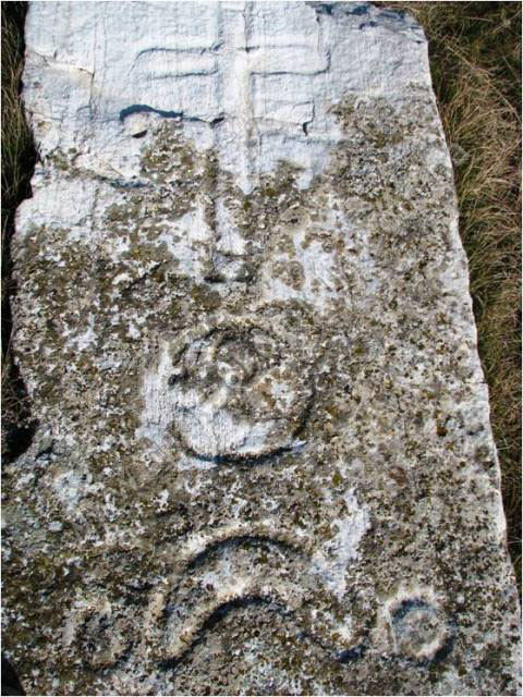
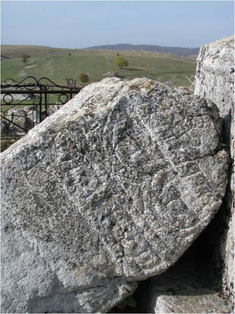
The
decorative motifs on the stećak at Kosan-krst are a cross, rosette, crescent
moon and circle, and at Kod Čekića, a Greek cross with the arms terminating in
volutes. The two gabled tombstones in the Orthodox cemetery are decorated with
rope-twists, rosettes, and a frieze of spirals and scrolling vines, while the
cruciform tombstones feature crescent moons, demi-orbs, a cudgel, and a shield
and sword.
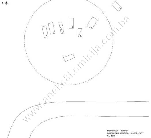
The necropolis at Kosan-krst
This site
contains 15 stećci in four different places up to 100 m apart. The stećci are
all chest-shaped, and only one is decorated. It is interesting to note that
beneath each stećak is a slight elevation, which P. Anđelić claims are
prehistoric grave mounds, a feature of this area(4).
The
stećci are located on a slight elevation resembling a prehistoric grave mound,
with a diameter of up to 3 m and a height of 0.50 to 1.00 m.
Stećak
no. 1. – chest without plinth, undecorated, of crude workmanship,
damaged and partly buried, lying west – east; the stećak measures 190 x 70 h=15
cm.
Stećak
no. 2. – chest without plinth, decorated, partly buried, lying west –
east; the stećak measures 195 x 80 h=23 cm.
The
eastern part of the stećak is decorated with a cross with an elongated upright,
the upright arm longer. Below it is a rosette and a crescent moon, beside which
to the south is a circle.
Stećak
no. 3. – slab without plinth, undecorated, partly buried and broken,
lying west – east; the stećak measures 200 x 50 h=24 cm.
Stećak
no. 4. – chest without plinth, undecorated, of crude workmanship,
damaged and partly buried, lying west – east; the stećak measures 178 x 81 h=33
cm.
Stećak
no. 5. – chest without plinth, undecorated, of crude workmanship,
damaged and partly buried, lying west – east; the stećak measures 145 x 65 h=52
cm.
Stećak
no. 6. – chest without plinth, undecorated, of crude workmanship,
damaged and partly buried, lying north-west – south-east; the stećak measures
187 x 105 h=22 cm.
Stećak
no. 7. – chest without plinth, undecorated, of crude workmanship,
damaged and partly buried, lying north – south; the stećak measures 180 x 75 partly
buried.
Stećak
no. 8. – chest without plinth, undecorated, of crude workmanship,
damaged and partly buried, lying north-east – south-west; the stećak measures
165 x 85 partly buried.
About 100
m to the north-west of this necropolis are another four stećci, on grave
mounds, two on each, with a road running between them. The prehistoric grave
mounds have a diameter of up to 3 m and a height of 0.50 to 1.00 m.
Stećak
no. 1. – chest without plinth, undecorated, of crude workmanship,
damaged and partly buried, lying west – east; the stećak measures 140 x 70 h=50
cm.
Stećak
no. 2. – chest without plinth, undecorated, of crude workmanship,
damaged and partly buried, lying west – east; the stećak measures 194 x 79 h=43
cm.
Stećak
no. 3. – chest without plinth, undecorated, of crude workmanship,
damaged and partly buried, lying west – east; the stećak measures 150 x 56 h=55
cm.
Stećak
no. 4. – chest without plinth, undecorated, of crude workmanship, damaged
and partly buried, lying west – east; the stećak measures 187 x 74 h=34 cm.
About 50
m to the east of the first necropolis are another two, on a grave mound with a
diameter of up to 3 m and a height of 0.50 to 1.00 m.
Stećak
no. 1. – chest without plinth, undecorated, of crude workmanship,
damaged and partly buried, lying west – east; the stećak measures 175 x 105
h=30 cm.
Stećak
no. 2. – chest without plinth, undecorated, of crude workmanship,
damaged and partly buried, lying west – east; the stećak measures 153 x 110
h=33 cm.
About 100
m to the north of the first necropolis is an isolated stećak.
Stećak
no. 1. – chest without plinth, undecorated, of crude workmanship, damaged
and partly buried, lying west – east; the stećak measures 160 x 80 h=67 cm.
The necropolis at Viš stijena
Twelve
stećci have been recorded here, two slab-shaped, eight chest-shaped and one
gabled. The site is dominated by a prehistoric grave mound on which one stećak
is standing; the others are arranged around it. The grave mound is 3 to 5 m in
diameter and 2 to 3 m in height.
Stećak
no. 1. – chest without plinth, undecorated, damaged and partly buried,
lying north – south; the stećak measures 167 x 66 h=52 cm.
Stećak
no. 2. – chest with plinth, undecorated, damaged and partly buried, lying
north – south; the stećak measures 150 x 68 h=63 cm; the plinth measures205 x
127 h=17 cm.
Stećak
no. 3. – chest without plinth, undecorated, of crude workmanship, lying
west – east; the stećak measures 176 x 73 h=44 cm.
Stećak
no. 4. – slab without plinth, undecorated, rough surface, lying
north-west – south-east; the stećak measures155 x 109 h=33 cm.
Stećak
no. 5. – chest without plinth, undecorated, damaged and partly buried,
lying north – south; the stećak measures 162 x 62 h=50 cm.
Stećak no.
6. – chest without plinth, undecorated, damaged and partly buried,
lying north – south; the stećak measures 173 x 82 h=52 cm.
Stećak
no. 7. – chest without plinth, undecorated, damaged and moved from its
original position to stand on the prehistoric grave mound, lying north – south;
the stećak measures 205 x 88 h=50 cm.
Stećak
no. 8. – gabled with plinth, undecorated, partly buried, lying north –
south; the stećak measures 152 x 57 h=36 cm.
Stećak
no. 9. – slab without plinth, undecorated, partly buried and lying north
– south; the stećak measures 115 x 50 h.
Stećak
no. 10. – chest without plinth, undecorated, damaged and partly buried,
lying north – south; the stećak measures 140 x 64 h=53 cm.
Stećak
no. 11. – chest without plinth, undecorated, damaged and partly buried,
lying north – south; the stećak measures 154 x 78 h=12 cm.
Stećak
no. 12. – chest without plinth, undecorated, damaged and partly buried,
lying north – south; the stećak measures 152 x 60 h=20 cm.
The necropolises at Babaluša and
Kod Čekića
Here
three chest-shaped stećci have been recorded alongside the road to Čuhovići. Stećak
no. 1 is on a prehistoric grave mound with a diameter of up to 3 m and a height
of 0.50 to 1.00 m.
About 50
m to the north is Kod Čekića, where there are eight chest-shaped stećci, one of
which is decorated with a Greek cross of which the arms terminate in volutes.
The necropolis at Babaluša
Stećak
no. 1. – chest without plinth, undecorated, of average workmanship, on a
small grave mound, lying west – east; the stećak measures 175 x 66 h=26 cm.
Stećak
no. 2. – chest without plinth, undecorated, of average workmanship,
lying west – east; the stećak measures 190 x 123 h=38 cm.
Stećak
no. 3. – chest without plinth, undecorated, of average workmanship,
lying north – south; the stećak measures 200 x 90 h=33.
The necropolis at Kod Čekića
Stećak
no. 1. – chest without plinth, undecorated, of crude workmanship, lying
north – south; the stećak measures 180 x 90 h=63 cm.
Stećak
no. 2. – chest without plinth, undecorated, of crude workmanship, lying
west – east; the stećak measures 158 x 87 h=29 cm.
Stećak
no. 3. – chest without plinth, undecorated, of average workmanship,
lying west – east; the stećak measures 191 x 87 h=49 cm.
Stećak
no. 4. – chest without plinth, undecorated, damaged, a piece broken off
the west side and lying about 10 m to the west of the stećak, lying west –
east; the stećak measures 178 x 80 h=65 cm.
Stećak
no. 5. – chest without plinth, decorated, of average workmanship, lying
south-west – north-east; the stećak measures 185 x 97 h=52 cm.
The
stećak is decorated with a Greek cross of which the arms terminate in volutes.
Stećak
no. 6. – chest without plinth, undecorated, of crude workmanship, lying
west – east; the stećak measures 230 x 123 h=30 cm.
Stećak no.
7. – chest without plinth, undecorated, of crude workmanship, lying
west – east; the stećak measures 167 x59 h=40 cm.
Stećak
no. 8. – chest without plinth, undecorated, of average workmanship,
lying north – south; the stećak measures 212 x 130 h=18 cm.
Prehistoric grave mound and
isolated stećak at Komadinov do
The
prehistoric grave mound at this site has a radius of 830 cm and a height of 150
cm. The stećak on the mound is chest-shaped and is lying north – south. The
stećak measures 195 x 100 h=35 cm.
Necropolis with stećci in an
Orthodox cemetery in active use
Seven
stećci have been recorded here (five gabled and two cruciform). They are of
fine workmanship, but are damaged. Four of them (two gabled and two cruciform)
are decorated. They are surrounded by the graves of the Orthodox population,
almost all of whose tombstones (crosses) have been destroyed, as has the
chapel, built between 1980 and 1990 and not subject to protection. Some
specimens of crosses can be found on the shores of the Blatačko lake.
Stećak
no. 1. – cruciform tombstone without plinth , decorated, lying west –
east; the stećak measures 178 x 73 d=43 cm.
The east
end is decorated with a cudgel, and the west end with a crescent moon. On the
north side is a demi-orb towards the base of the tombstone. The decorations are
in a combination of relief and reverse relief.
Stećak
no. 2. – cruciform tombstone without plinth, decorated, lying west –
east; the stećak measures 188 x 86 d=52 cm.
The east
end is decorated with two protuberances between which is a crescent moon; the
west end is decorated with the protuberances only. The north side is decorated
with a shield and sword motif near the base. The decorations are in relief.
Stećak
no. 3. – gabled with plinth, undecorated, overturned onto its north
side, lying west – east; the stećak measures 129 x 62 h=204 cm; the plinth
measures 183 x 136 h=39 cm.
Stećak
no. 4. – gabled with plinth, decorated, lying west – east; the stećak
measures 151 x 74 h=101 cm; the plinth measures184 x 104 h=24 cm.
Decorated
with a rope twist running across the ends and sides of the “roof”
Stećak
no. 5. – gabled with plinth, decorated, lying west – east; the stećak
measures 110 x 68 h= 140 cm; the plinth measures192 x 114 h=57 cm.
Decorated
with a rope twist, rosette and fries of spirals and scrolling vines.
Stećak
no. 6. – gabled with plinth, undecorated, overturned onto its north
side, lying west – east; the stećak measures 115 x 70 h=220 cm; the plinth
measures 180 x 100 h=22 cm.
Stećak
no. 7. – gabled with plinth, undecorated, overturned onto its east side,
lying north – south; the stećak measures 156 x 73 h=90 cm; the plinth
measures160x 50 h= 43 cm.
Necropolis with nišani in the village of Blace
This
necropolis formerly contained a quantity of nišani, only nine of which now
survive. Two large nišani, still standing upright and set in a stone surround,
stand out in particular. The other nišani are overturned and partly buried. The
three basic variations on the nišan: those with pleated turban, rectangular
nišani ending in a pyramid, and those in the form of a stele, together with the
visible remains of grave surrounds consisting of blocks of stone, suggest that
they date from the 15th century, when nišani first appeared in Bosnia and Herzegovina.
Nišan no.
1 a and b
Nišan
with pleated turban with mudževez (top of the nišan). The nišan measures 33 x
29 cm in section, and 120 cm in height to the turban.
The
footstone nišan ends in the form of a stele, and measures 30 x 38 cm with a
height of 145 cm.
Nišan no.
2.
Nišan in
the form of a stele, measuring 35 x 17 cm with a height of 150 cm.
Nišan no.
3 a and b
Nišan
with pleated turban with broken mudževez (top of the nišan). lying on
the ground. The nišan measures 29 x 29 cm in section, and 204 cm in overall
height, including the turban.
The
footstone nišan ends in the form of a stele, and measures 34 x 30 cm with a
height of 198 cm.
Nišan no.
4 a and b
Nišan
with pleated turban with broken mudževez (top of the nišan). lying on the
ground. The nišan measures 27 x 25 cm in section and 158 cm in overall height,
including the turban.
The
footstone nišan, with a pyramidal top, is lying on the ground. It measures 30 x
28 x 155 cm.
Nišan no.
5.
Nišan
with pleated turban with broken mudževez (top of the nišan). lying on the
ground and partly buried. The visible measurements are 23 x 16 cm in section
and 117 cm in height.
Nišan no.
6.
Nišan
with pleated turban with broken mudževez (top of the nišan). lying on the
ground and partly buried. The visible measurements are 25 x 22 cm in section
and 160 cm in height.
Description of the natural
heritage
The
mountain massif of Bjelašnica and Igman belongs to the central region of the
Dinaric alps, in the area of the high mountains of Površi and Brda; in
geotectonic terms, they belong to the zone of mesozoic limestone and dolomites
with the central Bosnian schist mountains at the core(5). Rendzina soils dominate the
zone from 1300 to 2000 m above sea level. These geomorphological features have
combined with the climatic conditions to create a very heterogeneous soil and
plant cover(6).
The
geographical location and orographic structure have dictated the area's
specific climate. This mountain massif separates an area with a markedly
Mediterranean climate from one with a continental climate. Generally speaking,
there are two types of climate here – an upland climate on the lower reaches of
the high plains and an alpine climate at high altitudes(7). The coldest month is February
(Bjelašnica - 7.4oC) and
the warmest is June (Bjelašnica 10.1oC). The average monthly and annual air temperature on Bjelašnica
is 1oC. The heaviest precipitation is
in September, October and November, a total of 382 mm. Snow cover lasts from
September until late May or mid June, and it is not unusual for Bjelašnica to
be snow-covered even in summer. The wind alternates between southerly winds off
the sea and north winds off the mainland, and there are high winds almost every
third day(8).
As a
result of these abiotic factors, combined with considerable zooanthropological
factors, a distinctive flora and vegetation has evolved on Bjelašnica(9).
The
Dinaric forest communities of beech and fir (with spruce) of neutrophile
character, constituting a marked band of forest vegetation, formed on limestone
soils, dolomitizing limestones and moraines. This community is one of the
forest communities of Bjelašnica that is richest in plant species,
predominantly mesophile neutrophile basiphile species. The dominant trees are
beech, fir and spruce, which are absent from the areas influenced by the
sub-Mediterranean climate. The shrub layer includes Euonymus latifolia,
Lonicera alpigena, Lonicera xylosteum, Lonicera nigra and Rhamnus fallax,
and the ground layer includes Asarum europaeum, Pulmonaria officinalis,
Lilium martagon, Paris
quadrifolia, and Cardamine enneaphyllos.
Above
these stands is a band of subalpine beech forest (Aceri-Fagetum subalpinum
Horv. et.al. 1974) of typical fastigiate habit, with a relatively short
growing vegetative period. The extreme climate conditions, which are even more
pronounced towards the upper limit of this stand, means that it has a primarily
protective role. The tree and shrub layer includes Fagus sylvatica, Acer
pseudoplatanus, Rhamnus fallax, Salix silesiaca, Lonicera barbasiama, Ribes
alpinum and Rubus saxatilis. The ground layer species include Adenostyles
alliariae, Cirsium erisithales, Ranunculus platanifolius, Valeriana montana and Valeriana
tripteris. At the limit of these stands are small groups of mountain pine
on the slopes of Hranisava (Mugo-Pinetum leucodermis Fuk. 1966). These
are relict stands largely destroyed by grazing, and constitute a natural
feature that should be protected. Thermophile species are to be found within
this community, including Scabiosa leucophylla, Erica carnea, Brachypodium
pinnatum and Calamagrostis varia(10).
The
Blatačko lake is at an altitude of 1156 m, on a karst plateau of Mt. Bjelašnica,
21 kilometres to the east of Konjic. The lake is rectangular in outline, and up
to 500 m long and 140 m wide. In summer, it is up to 2 metres deep. It is not
fed by any surface waters, but only by underground rivers. It is right beside
the Rakitnica gorge.
Running
along the middle from north to south is a spit on which various marsh plants
are growing. In summer, where the plant growth is thicker and there is
consequently less mud, it is possible to walk on the spit.
The
macrophytic plants that have been identified as growing on the spit along the
shore are Alisma plantago, Potamogeton natans, Typha latifolia, Polygonum
bistorta, Carex spp., Juncus spp., Batrachospermum spp., Lemna minor,
Utricularia vesiculosa, and large blankets of algae.
The
waters of the lake reach relatively high temperatures in summer, as much as 22°
C. This is the result of its shallowness and low volume of water, relatively
wide shores and exposure to the sun for much of the day, but for the same
reasons it also cools rapidly in bad weather. The temperature changes in this
kind of small lake are more rapid and extreme than in large, deep lakes. At
this altitude, the lake is partly frozen for four to five months a year, and
covered with snow.
The water
is yellowish-green in colour and moderately alkaline in reaction. It is used
mainly as a watering hole for livestock, which also fertilize the lake,
encouraging plant and animal life. Leeches, Hirundo medicinalis and Aulastomum
gulo, have been observed in the lake. Both zooplankton and phytoplankton
are quite extensive which, together with the presence of mineral and organic
detritus, some of which is blown in by the wind, means that the waters of the
lake are not very clear.
Since the
lake is isolated and not fed by surface waters where there might be fish, it
contains no indigenous ichthyofauna. The groups of phytoplankton represented
are Schizophyceae, Flagellatae, Dinoflagellatae, Bacillariaceae,
Consouthatae and Chlorophyceae, and of zooplankton, Rhizopoda,
Ciliata, Rotatoria, Crustacea, and Arthropoda larvae(11).
The lake
is surrounded by pastures. Much of the vegetation is low-growing, with
occasional shrubs and deciduous trees, mainly beech. To the north of the lake,
towards Mt Lovnica, the slopes that are not exposed to high winds are forested.
To the
south of the Blatačko lake are the Rakitnica gorge and Mt. Visočica.
The Rakitnica gorge, with its steep slopes and crags and shallow soils much
influenced by the sub-Mediterranean climate, contains thermophile communities
of downy oak and hop hornbeam (Querco-Ostryetum carpinifoliae) and of
manna ash and hop hornbeam (Ostryo-Ornetum). The tree species found within
these communities include Quercus pubescens, Ostrya carpinifolia, Fraxinus
ornus and Sorbus torminalis; shrubby species include Cornus mas,
Rhamnus cathartica, Viburnum lantana, Cotinus coggygria, Amelanchier ovalis
and Cotoneaster tomentosa. The ground-plant layer includes many
light-loving species, including Chrysanthemum corymbosum, Teucrium
chamaedrys, Mercurialis ovata, Galium lucidum, Stachys recta and Thymus
serpyllum(12).
Endemic
alpine meadow species
- Sesleria juncifolia
- Sesleria coerulens
- Festuca panciciana
- Festuca bosniaca
- Senecio bosniacus
- Veronica satureioides
- Gentiana dinarica
- Gentiana symphyandra
- Gentianella crispata
Glacial
relicts
- Dryas octopetala
- Polygonum viviparum
- Gentiana kochiana
- Nigritella nigra
- Potentilla clusiana
- Arnica montana
- Jasione orbiculata
- Achillea lingulata
- Lilium bosniacum
High
alpine flora of the alpine pastures, rocky terrain and Rakitnica gorge
Plants
found in the glacial cirques of Bjelašnica belong to the endemic association Amphoricarpion
autariati, and communities in the limestone gorge of the Rakitnica and on
dolomitic soils, where the following species of this distinctive flora have
been recorded:
- Edraianthus serpyllifolius
- Saxifraga caryophylla
- Minuartia clandestina
- Silene pusilla
- Alchemilla velebitica
- Cerastium dinaricum
The
following species are found on limestone soils:
- Dripis linneana
- Arabis alpina,
- Heracleum balcanicum,
- Stachys recta(13)
The
ichthyopopulation of the Tušilačka river and Rakitnica consists exclusively of
salmonids(14).
Reptiles
include the globally endangered meadow viper, Vipera ursini macrops,
classified as endangered by IUCN, along with other vipers – V. berus
bosniaca, V. amodites – and other snakes including Coronella austriaca,
Coluber sp, the legless lizard Anguis fragilis, other lizard species
– Lacerta vivipara, L. viridis, L. fragilis, L. Muralis – and frogs Hyla
arborea and Rana agilis.
The area
is also rich in invertebrates, with 127 recorded species of butterflies and
moths (Lepidoptera) and 29 of grasshoppers (Orthoptera). The area
is also the habitat of no fewer than 24 species recorded as endangered in Europe.
Invertebrates
classed as threatened in Europe, present in
the Igman-Bjelašnica-Treskavica-Visočica area
-
Threatened: Maculinea
nausithous (butterfly), Maculinea teleius (butterfly), Apatura metis
(butterfly);
-
Vulnerable: Dolomedes
plantarius (spider), Saga pedo (bush cricket), Hyles hippophaes (moth);
-
Rare: Helix pomatia (gastropod
- snail), Troglophantes gracilis (spider), Troglophantes similes (spider), Troglophantes
spinipes (spider), Parnassius apollo (butterfly), Erebia ottomana (butterfly), Epimyrma
ravouxi (ant);
-
Insufficiently known: Microcondylae
compressa (fresh-water mussel), Unio elegantus (fresh-water mussel), Hirudo
medicinalis (leech), Leucorrhinia pectoralis (dragonfly), Myrmeleon formicarius
(antlion), Syrichtus tesselum (butterfly), Papilio alexanor (butterfly),
Zerynthia polyxena (butterfly), Erebia calcari (butterfly).
The wider
area has some 110 species of bird, including, among confirmed birds of prey,
the golden eagle (Aquila chrysaetos) and the short-toed eagle (Circaetus
gallicus), the peregrine falcon (Falco peregrinus), the common
kestrel (Falco tinninculus), the goshawk (Accipiter gentilis),
the Eurasian sparrowhawk (Accipiter nisus) and the Levant
sparrowhawk (Accipiter brevipes). Only one species on the 2006 IUCN Red
List of Threatened Species, the globally vulnerable corncrake (Crex crex),
is found in the area(15).
Key
species of mammals are present in the area; chamois (Rupicapra rupicapra balcanica
L), as well as the brown bear (Ursus arctos L) and the wolf (Canis
lupus L) in the wider area, and another sixty or so species of mammal.
Larger
mammals include the roe deer (Capreolus capreolus), wild boar (Sus
scrofa), pine marten (Martes martes), which is already becoming much
rarer, stoat (Mustela erminea), wild cat (Felis silvestris) and
lynx (Lynx lynx)(16).
3. Legal status to date
The
Regional Plan for BiH to 2000 lists 69 sites of necropolises with stećci (3018
stećci) in Konjic
Municipality as Category
III monuments, without precise identification(17).
A letter
from the Institute for the Protection of Monuments of the Federal Ministry of
Culture and Sport dated 26 November 2008 lists the following properties:
1. Necropolis
of stećci Blace I, at Kosan krst, Municipality Konjic, mediaeval necropolis
(approx. 6 stećci),
2. Necropolis
of stećci Blace II, about 100m west of necropolis I, mediaeval necropolis
(approx. 4 stećci),
3. Necropolis
of stećci Blace III, on prominent tumulus at Viš stijena, mediaeval necropolis
(approx. 11 stećci),
4. Necropolis
of stećci Blace IV, at Babaluša, Municipality Konjic, mediaeval necropolis
(approx. 3 stećci),
5. Necropolis
of stećci Blace V, 150 m from necropolis IV at Kod Čekića, Municipality Konjic,
mediaeval necropolis (approx. 10 stećci), including Komadinov do, 70 m from
Blace V, isolated mediaeval stećak (1 stećak),
6. Necropolis
of stećci Blace VI, in modern Orthodox cemetery, village of Blace,
Municipality Konjic, mediaeval necropolis (approx. 7 stećci),
These
properties were not on the Register of Cultural Monuments of the Socialist
Republic of Bosnia and Herzegovina.
4. Research and conservation and
restoration works
Research
works, in the form of recording and gathering information on the stećci, were
carried out by Pavao Anđelić and published in 1975.
No
conservation or restoration works have been carried out.
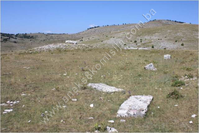
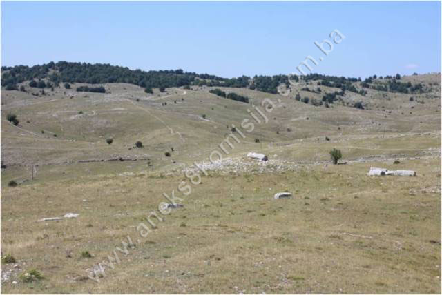
5. Current condition of the
property
The
findings of on-site inspections carried out on 16 May and 18 August
2009 are as follows:
-
the tombstones are at risk
of rapid deterioration as a result of neglect
-
some of the stećci and
nišani are chipped, damaged, overturned, or partly or almost wholly buried
-
the sites with the stećci
and nišani are not fenced, which enables the local residents to use the plots
as pasturage for their livestock
-
the tombstones are covered
to a greater or lesser extent with plant organisms (lichens and moss)
-
the tops of most of the
stećci are damaged to a greater or lesser extent (cracks, splits, flaking)
-
in the modern Orthodox
cemetery, the gabled stećci have been overturned, as have modern tombstones,
and the chapel has been vandalized
-
in the village as a whole,
most of the houses are in a ruinous state.
6. Specific risks
-
disintegration as a result
of long-term neglect
-
effects of the elements
-
self-sown vegetation.
III – CONCLUSION
Applying
the Criteria for the adoption of a decision on proclaiming an item of property
a national monument (Official Gazette of BiH nos. 33/02 and 15/03), the
Commission has enacted the Decision cited above.
The
Decision was based on the following criteria:
A. Time frame
B. Historical value
C. Artistic and aesthetic value
C.i. quality of workmanship
C.iii. proportions
C.v. value of details
D. Clarity
D.i. material evidence of a lesser known
historical era
D.iv. evidence of a particular type, style or
regional manner
E. Symbolic value
E.iii. traditional value
E.v. significance for the identity of a group of
people
G. Authenticity
G.i. form and design
G.ii. material and content
G.iv. traditions and techniques
G.vi. location and setting
The
following documents form an integral part of this Decision:
-
Copy of cadastral plan
-
Copy of land register
entry
-
Photodocumentation,
photographs taken on site
Bibliography
During
the procedure to designate the property as a national monument of Bosnia
and Herzegovina the following works were
consulted:
1927. Protić, Georg. “Hidrobiološke i plankton-studije na jezerima
Bosne i Hercegovine” (Hydrobiological and Plankton Studies in the Lakes of Bosnia and Herzegovina),
Jnl of the National Museum. Sarajevo:
Natural History, 1927
1932. Popović, Jovo. “Ljetni stanovi (mahale) na planini Bjelašnici”
(Summer quarters [Mahalas] on Mt. Bjelašnica), Jnl of the National Museum
(Natural History), Sarajevo,
vol. XLIV, 1931, 55-96
1975. Anđelić, Pavao. Historijski spomenici Konjica i okoline
(Historic monuments of Konjic and environs). Konjic: 1975, 34
1980. Various authors. Regional Plan for Bosnia and Herzegovina; Stage B –
valorization of natural, cultural and historical monuments. Sarajevo: Institute for architecture, town planning and
regional planning of the Faculty of Architecture in Sarajevo, 1980, 52
1982. Anđelić, Pavao. “Teritorijalno politička organizacija župe
Neretve i njezino mjesto u širim političkim okvirima” (Territorial and
political organization of the Neretva County and its place in the broader political
context) In: Studije o teritorijalnopolitičkoj organizaciji srednjovjekovne
Bosne (Studies on the territorial and political organization of mediaeval Bosnia). Sarajevo: 1982
1991. Tabaković-Tošić, Mara et.al. “Prilog poznavanju faune carabidae
(Coleoptera) planinskog masiva Igman-Bjelašnica” (Contribution to Knowledge of
the Carabidae [Coleoptera] fauna of the Igman-Bjelašnica Mountain Massif). Sarajevo: Jnl of the National Museum
of BiH – Natural History, 1991
1999. Beljkašić-Hadžidedić, Ljiljana. Bošnjačka nošnja na Bjelašnici
(Bosniac Costumes on Mt Bjelašnica), Sarajevo:
1999
2005. Mušeta-Aščerić, Vesna. Sarajevo
i njegova okolina u 15. stoljeću (Sarajevo
and Environs in the 15th century). Sarajevo:
2005
2006. Karović, Elma, Kunovac, Saša. Područje sa posebnim
karakteristikama: Igman-Bjelašnica-Treskavica i Kanjon Rakitnice (Visočica)
(An Area with Distinctive Characteristics: Igman- Bjelašnica-Treskavica and the
Rakitnica gorge (Visočica). Sarajevo:
2006
2006. Berilo, Zejnil. Aktuelno stanje populacije Velikog Tetrijeba u
planinskom kompleksu Igmana i Bjelašnice (Current State
of the Population of the Capercaillie on the Mountain Complex of Igman and
Bjelašnica). Sarajevo:
2006
2008. Various authors. Prirodna baština Kantona Sarajevo (The
Natural Heritage of Sarajevo Canton). Sarajevo:
2008
(1) Popović, Jovo,
„Ljetni stanovi (mahale) na planini Bjelašnici.“ Jnl of the National Museum
in Sarajevo (Natural History) XLIV/1932, Sarajevo: 1932. 59;
Beljkašić-Hadžidedić, Ljiljana, Bošnjačka nošnja na Bjelašnici, Sarajevo: 1999, 8.
(2) Anđelić,
Pavao, “Teritorijalno-politička organizacija župe Neretve i njezino mjesto u
širim političkim okvirima”, In: Studije o teritorijalno-političkoj
organizaciji Bosne i Hercegovine od najstarijih vremena do pada ovih zemalja
pod osmansku vlast. Sarajevo:
1982, 108-110.
(3) Anđelić, Pavao, op.cit., 1982, 110-156.
(4) Anđelić,
Pavao, Historijski spomenici Konjica i okoline, Konjic: 1975, 34, 35.
(5)
Tabaković-Tošić, Mara et.al., “Prilog poznavanju faune carabidae (Coleoptera)
planinskog masiva Igman-Bjelašnica”, Sarajevo:
Jnl of the National Museum (Natural History), 1991, 139-154.
(6) Berilo,
Zejnil, Aktuelno stanje populacije Velikog Tetrijeba u planinskom kompleksu
Igmana i Bjelašnice, Sarajevo:
2006, 6.-7.
(7)
Tabaković-Tošić, Mara, op.cit., Sarajevo:
1991, 140.
(8) Berilo,
Zejnil, op cit., Sarajevo:
2006, 8.-9.
(9)
Tabaković-Tošić, Mara, op.cit., Sarajevo:
1991, 140.
(10) Karović,
Elma; Kunovac, Saša, Područje sa posebnim
karakteristikama:Igman-Bjelašnica-Treskavica i Kanjon Rakitnice (Visočica),
Sarajevo: 2006,
10.-12.
(11) Georg
Protić, “Hidrobiološke i plankton-studije na jezerima Bosne i Hercegovine”, Sarajevo: Jnl of the
National Museum (Natural History), 1927, 3-42.
(12) Karović,
Elma; Kunovac, Saša, op.cit., Sarajevo:
2006, 10.-12.
(13) Karović,
Elma; Kunovac, Saša, op.cit., Sarajevo:
2006, 8.-9.
(14) Various
authors, Prirodna baština Kantona Sarajevo, Sarajevo: 2008, 116.
(15) Karović,
Elma; Kunovac, Saša, op.cit., Sarajevo:
2006, 28.
(16) Karović,
Elma; Kunovac, Saša, op.cit., Sarajevo:
2006, 31.
(17) Various
authors, Prostorni plan Bosne i Hercegovine, faza b – valorizacija, prirodne
i kulturno-historijske vrijednosti, Sarajevo:
Institut za arhitekturu, urbanizam i prostorno planiranje Arhitektonskog
fakultet u Sarajevu i Urbanistički zavod za Bosnu i Hercegovinu Sarajevo, 1980,
52.
|