Status of monument -> National monument
Published
in the “Official Gazette of BiH”, no. 50/10.
Pursuant
to Article V para. 4 Annex 8 of the General Framework Agreement for Peace in Bosnia and Herzegovina
and Article 39 para. 1 of the Rules of Procedure of the Commission to Preserve
National Monuments, at a session held from 8 to 11 September 2009 the
Commission adopted a
D E C I S
I O N
I
The
archaeological site of the prehistoric Neolithic settlement of Obre II at
Gornje polje in the village of Obre, Kakanj Municipality, is
hereby designated as a National
Monument of Bosnia and Herzegovina
(hereinafter: the National Monument).
The
National Monument consists of a Neolithic tell with a settlement dating from
the Neolithic period.
The
National Monument is located on a site designated as cadastral plot nos. c.p.
101, title deed no. 334 (new survey), corresponding to c.p. 384/3 (old survey),
Land Register entry no. 1326, c.p. 102, title deed no. 453 (new survey),
corresponding to c.p. 384/3 (old survey), Land Register entry no. 1326, c.p
103, title deed no. 345, (new survey), corresponding to c.p. 384/1 (old
survey), Land Register entry no. 1326, c.p. 104, title deed no. 332,
corresponding to part of c.p. 384/2 (old survey), Land Register entry no. 1326,
c.p. 105, title deed no. 337, (new survey), corresponding to c.p. 384/2 (old
survey), Land Register entry no. 1326, c.p. 106, title deed no. 451 (new
survey), corresponding to c.p. 383 (old survey), Land Register entry no. 1596,
c.p. 107, title deed no. 336, corresponding to part of c.p. 384/2 (old survey),
Land Register entry no. 1326, part of c.p. 109/1, title deed no. 321 (new
survey), corresponding to c.p. 380/1 (old survey), Land Register entry no. 781,
c.p. 109/2, title deed no. 321 (new survey), corresponding to c.p. 359/4 (old
survey), Land Register entry no. 912, c.p. 110, title deed no. 423 (new
survey), corresponding to c.p. 387/2 (old survey), Land Register entry no.
1008, c.p. 111, title deed no. 643 (new survey), corresponding to c.p. 388/1
(old survey), Land Register entry no. 1673, c.p. 112, title deed no. 204 (new
survey), corresponding to c.p. 388/2, 388/3 (old survey), Land Register entry
no. 1673, c.p. 113, title deed no. 204 (new survey), corresponding to c.p.
388/2 (old survey), Land Register entry no. 1673, c.p. 115 title deed no. 350 (new
survey), corresponding to c.p. 388/4 (old survey), Land Register entry no.
1673, c.p. 116/1, title deed no. 342 (new survey), corresponding to part of
c.p. 380/2 (old survey), Land Register entry no. 1682, part of c.p. 116/2,
title deed no. 322 (new survey), corresponding to c.p. 379 (old survey), Land
Register entry no. 1467, c.p. 117, title deed no. 138 (new survey),
corresponding to c.p. 378/3 (old survey), Land Register entry no. 1418, c.p.
118, title deed no. 295 (new survey), corresponding to c.p. 378/1 (old survey),
Land Register entry no. 1418, part of c.p 119, title deed no. 163 (new survey),
corresponding to c.p. 378/2 (old survey), Land Register entry no. 753, part of
c.p. 120, title deed no. 617, corresponding to c.p. 377/1 (old survey), Land Register
entry no. 1288, part of c.p. 122, title deed no. 288 (new survey),
corresponding to c.p. 377/2 (old survey), Land Register entry no. 1288, c.p.
123/1, title deed no. 137 (new survey), corresponding to c.p. 376/2 (old
survey), Land Register entry no. 13, c.p. 123/2, title deed no. 545 (new
survey), corresponding to c.p. 376/4 (old survey), Land Register entry no. 14,
c.p. 124/1, title deed no. 138 (new survey), corresponding to c.p. 375/1 (old
survey), Land Register entry no. 1296, c.p. 124/2, title deed no. 546 (new
survey), corresponding to c.p. 376/1 (old survey), Land Register entry no. 905,
c.p. 125/1, title deed no. 640 (new survey), corresponding to c.p. 375/2 (old
survey), Land Register entry no. 1296, c.p. 125/2, title deed no. 246 (new survey),
corresponding to c.p. 375/3 (old survey), Land Register entry no. 1296, c.p.
125/3, title deed no. 631 (new survey), corresponding to c.p. 375/7 (old
survey), Land Register entry no. 1296, c.p. 125/4, title deed no. 632 (new
survey), corresponding to c.p. 375/8 (old survey), Land Register entry no.
1296, c.p. 126, title deed no. 633 (new survey), corresponding to c.p. 375/4
(old survey), Land Register entry no. 1296, c.p. 127, title deed no. 638 (new
survey), corresponding to c.p. 375/5 (old survey), Land Register entry no.
1296, c.p. 130, title deed no. 411 (new survey), corresponding to c.p. 374/1
(old survey), Land Register entry no. 1252, c.p. 131, title deed no. 362 (new
survey), corresponding to c.p. 374/3 (old survey), Land Register entry no. 1252,
c.p. 132, title deed no. 342 (new survey), corresponding to c.p. 374/2 (old
survey), Land Register entry no. 331, c.p. 133/1, title deed no. 321 (new
survey), corresponding to c.p. 373/1 (old survey), Land Register entry no. 815,
c.p. 133/2, title deed no. 527 (new survey), corresponding to c.p. 373/5 (old
survey), Land Register entry no. 516, c.p. 133/3, title deed no. 644 (new
survey), corresponding to c.p. 373/6 (old survey), Land Register entry no.
1437, c.p. 134, title deed no. 121 (new survey), corresponding to c.p. 373/3
(old survey), Land Register entry no. 409. The plots are in cadastral
municipality Bjelavići under the new survey, and c.m. Obre under the old
survey, Kakanj Municipality,
Federation of Bosnia and Herzegovina,
Bosnia and Herzegovina.
The
provisions relating to protection measures set forth by the Law on the
Implementation of the Decisions of the Commission to Preserve National
Monuments, established pursuant to Annex 8 of the General Framework Agreement
for Peace in Bosnia and Herzegovina (Official Gazette of the Federation of BiH
nos. 2/02, 27/02, 6/04 and 51/07) shall apply to the National Monument.
II
The
Government of the Federation of Bosnia and Herzegovina (hereinafter: the
Government of the Federation) shall be responsible for providing the legal,
scientific, technical, administrative and financial measures necessary for the
protection, conservation and presentation of the National Monument.
The
Commission to Preserve National Monuments (hereinafter: the Commission) shall
determine the technical requirements and secure the funds for preparing and
setting up signboards with basic details of the monument and the Decision to
proclaim the property a National Monument.
III
To ensure
the on-going protection of the National Monument on the area defined in Clause
1 para. 3 of this Decision, the following protection measures are hereby
stipulated:
Protection
Level I applies to part of c.p. no. 103, c.p. no. 104, c.p. no. 105, c.p.
no. 106, c.p. no. 107, c.p. no. 109/1, c.p. no. 109/2, c.p. no. 112, c.p. no.
116/1, c.p. no. 116/2, c.p. no. 118, part of c.p. no. 119, part of c.p. no.
120, part of c.p. no. 122, c.p. no. 123/1, c.p. no. 124/1, c.p. no. 125/1, c.p.
no. 125/2, c.p. no. 125/3, c.p. no. 125/4, c.p. no. 132. In this zone the following
protection measures shall apply:
-
all works are prohibited
other than research and conservation and restoration works, which shall ensure
the sustainable use of the site, and works designed to display the monument,
with the approval of the Federal Ministry responsible for regional planning
(hereinafter: the relevant ministry) and under the expert supervision of the
heritage protection authority of the Federation of Bosnia and Herzegovina
(hereinafter: the heritage protection authority);
-
the site of the monument
shall be open and accessible to the public once systematic investigative works
have been completed and conservation and presentation measures and management
mechanisms are in place;
-
infrastructure works shall
be permitted with the approval of the relevant ministry and subject to the
expert opinion of the heritage protection authority;
-
shallow ploughing to a
depth of 20 cm is permitted;
-
the planting of trees is
prohibited;
-
alterations to the course
of the river Trstionica are prohibited;
-
the dumping of all kinds
of waste is prohibited.
Protection
Level II pertains to c.p. no. 101, c.p. no. 102, part of c.p. no. 103,
c.p. no. 110, c.p. no. 111, c.p. no. 113/1, c.p. no. 113/2, c.p. no. 115, c.p.
117, part of c.p. no. 119, part of c.p. no. 120, part of c.p. no. 122, c.p. no.
123/2, c.p. no. 124/2, c.p. no. 126, c.p. no. 127, c.p. no. 130, c.p. no. 131,
c.p. no. 133/1, c.p. no. 133/2, c.p. no. 133/3, c.p. no. 134/1, c.p. no. 134/2.
In this zone the following protection measures shall apply:
-
this buffer zone is
a potential archaeological site, in consequence of which the construction of
new buildings is prohibited, as are all works that could have the effect of
destroying the archaeological stratum or altering the appearance of the
National Monument without a prior field survey by a qualified archaeologist and
subject to the approval of the relevant ministry and under the supervision of
the heritage protection authority;
-
the dumping of waste is
prohibited.
The
Government of the Federation of Bosnia and Herzegovina
shall be responsible in particular for designing a project for an
archaeological park at the Obre II site in Kakanj Municipality
which shall properly present the Butmir culture to the general public.
IV
All
movable artefacts found during the course of archaeological investigations
(hereinafter: the movable artefacts) shall be deposited in the nearest museum
able to provide the necessary personnel, material and technical conditions or
in the National Museum of Bosnia and Herzegovina in Sarajevo, catalogued, and
suitably presented.
The
removal of the movable artefacts from Bosnia and Herzegovina is
prohibited.
By way of
exception to the provisions of paragraph 2 of this Clause, if the leader of the
investigations determines that the movable artefacts must be processed abroad,
he/she shall provide evidence to that effect to the Commission, which may
approve the temporary removal of the movable artefacts subject to detailed
conditions for their export.
Upon
receipt of a report on the investigations conducted, the Commission shall
identify which movable artefacts shall be subject to protection measures to be
determined by the Commission.
In
granting permission for the temporary removal of the movable artefacts, the
Commission shall stipulate all the conditions under which the removal from
Bosnia and Herzegovina may take place, the date by which the items shall be
returned to the country, and the responsibility of individual authorities and
institutions for ensuring that these conditions are met, and shall notify the
Government of the Federation, the relevant security service, the customs
authority of Bosnia and Herzegovina, and the general public accordingly.
All
movable and immovable archaeological material found during the archaeological
investigations shall be professionally catalogued and processed.
The
archaeologist heading the archaeological investigations shall be responsible on
completion of the archaeological works for submitting a report to the
institution conducting the investigations.
The archaeologist
heading the archaeological investigations must have access to all the movable
and immovable archaeological material found for the duration of the
investigations and until such time as the report has been completed, for a
period not exceeding 3 years.
Simultaneously
with carrying out the archaeological investigations, the immovable finds made
on site shall be conserved, as shall the movable archaeological material, which
shall be stored in suitable premises.
V
All
executive and area development planning acts are hereby revoked to the extent
that they are not in accordance with the provisions of this Decision.
VI
Everyone,
and in particular the competent authorities of the Federation of Bosnia and
Herzegovina, the Canton, and urban and municipal authorities, shall refrain
from any action that might damage the National Monument or jeopardize the
preservation thereof.
VII
The
Government of the Federation, the Federal Ministry responsible for regional
planning, the Federation heritage protection authority, and the Municipal
Authorities in charge of urban planning and land registry affairs, shall be
notified of this Decision in order to carry out the measures stipulated in
Articles II to VI of this Decision, and the Authorized Municipal Court shall be
notified for the purposes of registration in the Land Register.
VIII
The
elucidation and accompanying documentation form an integral part of this
Decision, which may be viewed by interested parties on the premises or by
accessing the website of the Commission (http://www.aneks8komisija.com.ba)
IX
Pursuant
to Art. V para 4 Annex 8 of the General Framework Agreement for Peace in Bosnia and Herzegovina,
decisions of the Commission are final.
X
This
Decision shall enter into force on the day following its publication in the
Official Gazette of BiH.
This
Decision has been adopted by the following members of the Commission: Zeynep
Ahunbay, Martin Cherry, Amra Hadžimuhamedović, Dubravko Lovrenović, and
Ljiljana Ševo.
No: 02-2-40/09/51
9 September 2009
Sarajevo
Chair of
the Commission
Amra
Hadžimuhamedović
E l u c i
d a t i o n
I – INTRODUCTION
Pursuant
to Article 2, paragraph 1 of the Law on the Implementation of the Decisions of
the Commission to Preserve National Monuments, established pursuant to Annex 8
of the General Framework Agreement for Peace in Bosnia and Herzegovina, a
“National Monument” is an item of public property proclaimed by the Commission
to Preserve National Monuments to be a National Monument pursuant to Articles V
and VI of Annex 8 of the General Framework Agreement for Peace in Bosnia and
Herzegovina and property entered on the Provisional List of National Monuments
of Bosnia and Herzegovina (Official Gazette of BiH no. 33/02) until the
Commission reaches a final decision on its status, as to which there is no time
limit and regardless of whether a petition for the property in question has
been submitted or not.
On 15
April 2009, Zilka Kujundžić-Vejzagić, a museum consultant at the National
Museum of Bosnia and Herzegovina, submitted a proposal/petition to designate
the archaeological site of the Neolithic settlement of Obre II at Gornje polje,
Kakanj Municipality,
Federation of Bosnia and Herzegovina,
Bosnia and Herzegovina,
as a national monument.
Pursuant
to the law, the Commission proceeded to carry out the procedure for reaching a
final decision to designate the Property as a National Monument, pursuant to
Article V para. 4 of Annex 8 and Article 35 of the Rules of Procedure of the
Commission to Preserve National Monuments.
Statement of significance
Thanks to
the extremely well-preserved stratigraphic details of Obre II, it has been
established with absolute certainty that the Butmir cultural group to which the
settlement belonged developed in three basic chronological stages; Butmir I,
Butmir II and Butmir III, whereby the Butmir culture became part of the great
cultural complex of south-eastern Europe.
Major
systematic excavations were carried out on the site from 1963 to 1968. Carbon
14 analysis established that the settlement dated from 5310-4910 to 4780-4440
BCE. The remains of well-preserved above-ground houses were found in the area
excavated, with particular attention paid to the two-room houses with domed
ovens in the main room. Eleven human skeletons were found in the area
excavated, as a result of which this site also provided the first information
on the cult of the dead in the Butmir culture.
II – PRELIMINARY PROCEDURE
In the
procedure preceding the adoption of a final decision to proclaim the property a
national monument, the following documentation was inspected:
-
Documentation on the
location and current owner and user of the property (copy of cadastral plan and
copy of land registry entry).
-
Data on the current
condition and use of the property, including a description and photographs,
data of war damage, data on restoration or other works on the property, etc.
-
Historical, architectural
and other documentary material on the property, as set out in the bibliography
forming part of this Decision.
The
findings based on the review of the above documentation and the condition of
the site are as follows:
1. Details of the property
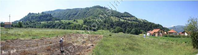
Location
The
Neolithic settlement of Obre II is located on a terraced elevation in the river
Trstionica valley, at Gornje polje, about 8 km south-east of Kakanj in the
village of Obre, between the Kakanj to Kraljeva Sutjeska road and the right
bank of the river Trstionica, which comes from the east and flows into the
river Bosna somewhat less than three kilometres downstream.
The
National Monument is located on a site designated as cadastral plot nos. c.p.
101, title deed no. 334 (new survey), corresponding to c.p. 384/3 (old survey),
Land Register entry no. 1326, c.p. 102, title deed no. 453 (new survey),
corresponding to c.p. 384/3 (old survey), Land Register entry no. 1326, c.p
103, title deed no. 345, (new survey), corresponding to c.p. 384/1 (old
survey), Land Register entry no. 1326, c.p. 104, title deed no. 332,
corresponding to part of c.p. 384/2 (old survey), Land Register entry no. 1326,
c.p. 105, title deed no. 337, (new survey), corresponding to c.p. 384/2 (old
survey), Land Register entry no. 1326, c.p. 106, title deed no. 451 (new
survey), corresponding to c.p. 383 (old survey), Land Register entry no. 1596,
c.p. 107, title deed no. 336, corresponding to part of c.p. 384/2 (old survey),
Land Register entry no. 1326, part of c.p. 109/1, title deed no. 321 (new
survey), corresponding to c.p. 380/1 (old survey), Land Register entry no. 781,
c.p. 109/2, title deed no. 321 (new survey), corresponding to c.p. 359/4 (old
survey), Land Register entry no. 912, c.p. 110, title deed no. 423 (new
survey), corresponding to c.p. 387/2 (old survey), Land Register entry no.
1008, c.p. 111, title deed no. 643 (new survey), corresponding to c.p. 388/1
(old survey), Land Register entry no. 1673, c.p. 112, title deed no. 204 (new
survey), corresponding to c.p. 388/2, 388/3 (old survey), Land Register entry
no. 1673, c.p. 113, title deed no. 204 (new survey), corresponding to c.p.
388/2 (old survey), Land Register entry no. 1673, c.p. 115 title deed no. 350
(new survey), corresponding to c.p. 388/4 (old survey), Land Register entry no.
1673, c.p. 116/1, title deed no. 342 (new survey), corresponding to part of
c.p. 380/2 (old survey), Land Register entry no. 1682, part of c.p. 116/2,
title deed no. 322 (new survey), corresponding to c.p. 379 (old survey), Land
Register entry no. 1467, c.p. 117, title deed no. 138 (new survey),
corresponding to c.p. 378/3 (old survey), Land Register entry no. 1418, c.p.
118, title deed no. 295 (new survey), corresponding to c.p. 378/1 (old survey),
Land Register entry no. 1418, part of c.p. 119, title deed no. 163 (new
survey), corresponding to c.p. 378/2 (old survey), Land Register entry no. 753,
part of c.p. 120, title deed no. 617, corresponding to c.p. 377/1 (old survey),
Land Register entry no. 1288, part of c.p. 122, title deed no. 288 (new
survey), corresponding to c.p. 377/2 (old survey), Land Register entry no.
1288, c.p. 123/1, title deed no. 137 (new survey), corresponding to c.p. 376/2
(old survey), Land Register entry no. 13, c.p. 123/2, title deed no. 545 (new
survey), corresponding to c.p. 376/4 (old survey), Land Register entry no. 14,
c.p. 124/1, title deed no. 138 (new survey), corresponding to c.p. 375/1 (old
survey), Land Register entry no. 1296, c.p. 124/2, title deed no. 546 (new
survey), corresponding to c.p. 376/1 (old survey), Land Register entry no. 905,
c.p. 125/1, title deed no. 640 (new survey), corresponding to c.p. 375/2 (old
survey), Land Register entry no. 1296, c.p. 125/2, title deed no. 246 (new
survey), corresponding to c.p. 375/3 (old survey), Land Register entry no.
1296, c.p. 125/3, title deed no. 631 (new survey), corresponding to c.p. 375/7
(old survey), Land Register entry no. 1296, c.p. 125/4, title deed no. 632 (new
survey), corresponding to c.p. 375/8 (old survey), Land Register entry no.
1296, c.p. 126, title deed no. 633 (new survey), corresponding to c.p. 375/4
(old survey), Land Register entry no. 1296, c.p. 127, title deed no. 638 (new
survey), corresponding to c.p. 375/5 (old survey), Land Register entry no.
1296, c.p. 130, title deed no. 411 (new survey), corresponding to c.p. 374/1
(old survey), Land Register entry no. 1252, c.p. 131, title deed no. 362 (new
survey), corresponding to c.p. 374/3 (old survey), Land Register entry no.
1252, c.p. 132, title deed no. 342 (new survey), corresponding to c.p. 374/2
(old survey), Land Register entry no. 331, c.p. 133/1, title deed no. 321 (new
survey), corresponding to c.p. 373/1 (old survey), Land Register entry no. 815,
c.p. 133/2, title deed no. 527 (new survey), corresponding to c.p. 373/5 (old
survey), Land Register entry no. 516, c.p. 133/3, title deed no. 644 (new
survey), corresponding to c.p. 373/6 (old survey), Land Register entry no.
1437, c.p. 134, title deed no. 121 (new survey), corresponding to c.p. 373/3
(old survey), Land Register entry no. 409. The plots are in cadastral municipality
Bjelavići under the new survey, and c.m. Obre under the old survey, Kakanj Municipality,
Federation of Bosnia and Herzegovina,
Bosnia and Herzegovina.
The Land
Register records reveal that the plots are in private ownership, belonging to
persons from Kakanj
Municipality.
Historical information
The
geographical location of Bosnia and Herzegovina, between the eastern Adriatic
coast and the central Balkans, together with its geomorphic features, were
among the factors that have dictated its cultural and historical evolution over
many millennia, but perhaps most markedly during the Neolithic period(1).
The
Neolithic period in Bosnia
and Herzegovina covers the period from the
6th to the beginning of the 3rd millennium(2).
Population
changes in the late Neolithic and during the Eneolithic period brought with
them changes to the spiritual and material culture and, inevitably, to the
nature of the economy.
Major
changes came about with the introduction of copper, entailing the gradual
development of new activities, such as prehistoric mining and copper
metallurgy. This in turn led to certain changes in the nature of trading
relations, with the exchange of copper artefacts. Society changed from a
matriarchal to a patriarchal basis. Wide-ranging economic development and a
greatly reduced dependence on agriculture contributed to the dwindling of the
belief among Eneolithic people in the fertility of the land as the universal
womb equated with female fertility. The most striking indication of these
changes is the disappearance of figural sculptures. In addition, an entirely
new attitude to the deceased emerged, with the introduction of grave goods in
the true sense of the word.
The
Eneolithic in Bosnia and
Herzegovina covers most of the third
millennium, and marked a break with the Neolithic period and the gradual
degeneration of Neolithic cultures, experienced in every aspect of life. A
major cause of these changes was the population movements that affected the
whole of the Balkan peninsula, resulting in
the Indo-Europeanization of the region. The Neolithic cultures were unable to
withstand the powerful pressures from the east(3).
The Obre
II settlement belonged to the inner river Bosna valley region, where the river
formed the main Neolithic highway in Bosnia,
linking the Sava valley (the Sava basin and Pannonia)
with central Bosnia.
Upstream, the river Bosna leads to the river Fojnica valley, and thence to
routes westwards and southwards, including towards the Adriatic.
This meant that the area between Kakanj and Visoko was relatively densely
populated during the Neolithic period. The principal Neolithic habitats in the
area were:
1. Raskršće
(Obre I), which can now claim to be the oldest Neolithic settlement in central Bosnia,
2. Kakanj,
the eponymous site for the Kakanj Neolithic group, 6 km from Obre,
3. Arnautovići
near Visoko, representing a later stage of the Kakanj culture,
4. Okolište,
between Arnautovići and Kakanj, belonging to the more advanced Butmir culture,
5. Gornje
polje (Obre II).
Taking a
rather broader view, one might add such settlements as Butmir near Sarajevo, a Butmir-group
settlement in Kiseljak, Nebo and Mujevine in the Bila valley near Travnik,
Crkvina near Turbe and so on. All these settlements suggest that central Bosnia
was a major Neolithic region, with not only the Kakanj cultural group (Obre I –
Kakanj – Arnautovići) and the Butmir cultural group (Obre II – Butmir –
Okolište – Nebo), but also people of the Starčevo culture living there; in
addition to which, there is evidence of the influence of the Vinča and Lengyel
styles(4).
2. Description of the property
In 1958
the National Museum
embarked on a systematic field survey and information-gathering in order to
compile an archaeological map of Bosnia and Herzegovina. In 1961, as
part of this survey, the area of central Bosnia
from Kraljeva Sutjeska to Ćatići near Kakanj was surveyed, and the existence of
a sizeable Neolithic settlement was recorded at Gornje polje in the village of Obre. The first sondage was carried out
on the site in August 1973, when a small area of 25 m² was excavated – trench A
– on the edge of the central part of the settlement. This provided basic
information on the settlement that was then used as the starting-point and
guidelines for further investigations. The cultural layer is 2.90/3.00 m thick,
and provided the first clues to the stratigraphy of the settlement. The pottery
finds covered three stages of the development of the Butmir culture on this
site:
a) the
earlier stage – 2.90/3.00 – 2.20/2.30 m – with red-pigmented pottery sherds and
some features of the Kakanj style,
b) the
middle stage – 2.20/2.30 – 1.10/1.20 m – with already familiar Butmir style
pottery wares,
c) the
later stage – 1.10/1.20 – 0.00 m – lacking spiral decorations, and with
quantities of pottery sherds in the Lisičići style.
The next
sondage at Gornje polje was conducted in July and August 1964 when trench B was
opened, covering an area of 50 m², and providing confirmation of the
observations from the previous excavations as well as additional information on
the numerous remains of various features (especially hearths and querns). The
cultural layer was of the same thickness as in the previous excavations, but
the features of the various strata provided a better insight into the life of
the inhabitants of the settlement. Of particular note were finds of Butmir
pottery from the middle cultural stage.
The third
sondage was conducted in July and August 1965, when trenches C and D were
opened, each covering an area of 50 m², close to the centre of the settlement,
as a result of which the cultural layer was thicker, ranging from 3.25 to 3.30
m. In trench C, the hollow of a dug-out pit was found in the subsoil. Obvious
pottery elements of the Kakanj group were recorded in the lower strata,
providing the first evidence that the origins of the Butmir culture were
closely linked to the preceding indigenous base. Sherds of finely glazed vases
decorated with red and yellow pigments were also recorded. During these
excavations it was found that the classic Butmir pottery was restricted to the
strata at depths of 2.50 to 1.00 m, with later wares showing signs of
degeneration. The upper strata (the later stage) provided evidence of a
considerable influx of pottery elements from the Lisičići group. During these
excavations, minor soundings were also taken in the nearby Neolithic settlement
at Raskršće, which is about 200 m from Gornje polje, but which has no direct
chronological or cultural connection with it. Cultural strata with pottery of
the Starčevo and Kakanj types were found at Raskršće, of an earlier culture
than the one at Gornje polje. Based on this, the site at Raskršće was named
Obre I and the site at Gornje polje became Obre II.
The next
sondage was conducted from 14 August to 30 September 1967, when an area of 400
m² was excavated. The thickness and contents of the cultural strata, together
with the finds on the subsoil, confirmed that this open area was the centre of
the settlement. The next parallel excavations at Gornje polje and Raskršće were
carried out from 24 June to 18 August 1968(5), when an area of 450 m² was excavated at Gornje polje, extending
the area excavated the year before towards the east and south. A small trench,
no. VIII, of 25 m² was shifted eastwards to provide some information on this
side of the settlement. In the spring of 1968 borings were taken in the main
directions in which the settlement extended, confirming that the 1967
excavations had covered the centre of the settlement and that further excavations
should continue as in 1968. Though the excavations were extensive, they covered
only a small part of the settlement – a mere fifteenth(6).
The
Neolithic settlement of Obre II is located on the right bank of the river
Trstionica (Trstivnica), a tributary of the river Bosna to its right, on an
elevated Pleistocene terrace, used to this day solely for agricultural
purposes. The entire site is divided into numerous privately-owned plots, most
of whose owners live in the villages of Bjelavići and Obre (in Kakanj Municipality).
To the south, the Neolithic settlement ends at a steep hillside, and to the
north it merges into the somewhat hilly terrain on the far side of which is
Kakanj. The Tristionica riverbed has twice changed course at Gornje polje. At
first it flowed very close to the Neolithic settlement, later to shift about 50
m southwards to cut a bed at the edge of the hill, thereby moving another 150 m
southwards and creating two river terraces. The Neolithic settlement was
located on the higher, relatively wide and level terrace dominating the river
at this point. In addition to favourable conditions for agriculture, the
surrounding hills and slopes provided excellent pasturage, and the forests to
the east were ideal hunting grounds. To this day a spring of potable water
rises above the site, while the river Bosna valley provided several varieties
of stone and flint needed to make tools. Not far from the settlement, large
quantities of high-quality yellow clay were found, so that the material needed
to build houses and produce pottery wares was readily to hand. All these
features resulted in two stages of Neolithic settlement in the area(7).
Three
separate areas were covered by the sondage and systematic excavations of Obre
II:
1) trenches
A and B,
2) trenches
C – D and I – VII,
3) trench
VIII.
The first
two trenches were the result of preliminary investigations and the first
details to emerge, but were joined to form a single sondage providing a test
view of the western part of the settlement. Another single group of trenches
consisted of C-D-I-VII, the basic area covering an entire section of the
settlement and providing all the basic information on the stratigraphy,
communal organization, varieties and types of finds on this site. Trench VIII
was of the same kind as the first group, and was opened to provide a view of
the eastern part of the settlement. The excavations as a whole covered an area
of 1050 m² (175+850+25 m²). The main excavations were 850 m² in area, providing
an overview of the structures uncovered over a sizeable area. Most of the
vertical profiles were 10 or 9.5 m long, with six profiles in trenches V, VI
and VII 15 and 14.5 m long. Forty-eight vertical profiles were recorded over
the entire excavated area. The excavations were carried out by removing the
soil uniformly, in layers of about 15 cm at a time. The entire documentation,
including geodetic surveys and the results of the various analyses, is housed
in the documentation centre of the Archaeological Department of the National Museum(8).
The
Neolithic agglomeration of Obre II, which grew to cover an area of
19,000–20,000 m², is of the usual kind in the Balkans, forming a sizeable,
densely populated Neolithic settlement. The greatest density was observed in
the area designated as Zone I, the centre of the settlement, where the cultural
layer was 3.30 – 3.80 m thick on average, and the area covered was about 8,000
– 9,000 m². This zone was permanently inhabited, and the houses were constantly
being rebuilt.
Zone 2 of
the settlement covered the eastern end of the second terrace. Here the cultural
layer was 2.80 – 1.60 m thick, and represented an extension of the original
settlement, where there was no need to keep rebuilding as in the centre.
Zone 3
consisted of the outskirts of the settlement(9).
Eight
habitation horizons were identified in trenches I-VII from a combination of
profiles and parallel studies of the horizontal plans in Obre II, with
intermediate horizons forming from time to time depending on the evolution of
the conditions of habitation. The earliest period belonged to horizons 1 and 2,
the more developed period to horizons 3, 4 and 5, and the late period of the
settlement to horizons 6, 7 and 8. The features represented in these habitation
horizons were houses and other buildings, hearths, fireplaces, ovens, ash-pits,
working areas (quern stones, flint workings, burnishing areas), various pits,
and places of worship.
The
materials used to build the houses and other buildings were wood, stone and
clay, resulting in the following types of buildings:
1. buildings
of all three materials,
2. buildings
of timber and clay (wattle and daub),
3. timber
buildings.
The
oldest houses were rectangular in form, and were of stone, wood and daub; some
were hollowed out inside, thus resembling a semi-dug-out house.
The best
examples of houses belonged to the middle period, the more advanced stage of
the Butmir culture, consisting of the remains of two-roomed houses built above
ground, lying north-east/south-west with a partition wall from north-east to
south-west. The two-roomed house was thus the basic type of house in Obre II. Inside
the houses, walls were found dividing the house into separate rooms, along with
a domed oven in every house, and pottery vessels, vases, grain and so on. The
timber houses had only one room.
The
construction of proper houses in Obre II underwent three stages:
a) houses
with stone foundations, reinforced by the wooden posts of the framework and the
lower part of the walls. The top part of the walls of these houses was of
lightweight construction, and they cannot therefore be compared with the later
houses in the settlement;
b)
two-roomed houses with a clearly defined layout, standard interior fittings and
thick walls. This is the classic Butmir culture house, belonging to the middle
period of the settlement (habitation horizons 3 to 6);
c)
degenerate forms of the two-roomed house in the final two habitation horizons(10).
The
settlement was of the compact variety, with the entire village consisting of
fifty to sixty houses, indicating that the population ranged from 300 to 400. The
basic type of village was dictated by the rows of houses. The residents were
mainly engaged in livestock rearing, agriculture and trade. There was evidence
of the cult of the dead in the settlement, with eleven child burials,
associated with wider Mediterranean burial customs and the sacrifice of small
children to protect the settlement and encourage fertility. From the very
outset the inhabitants of the village were notable agriculturalists and
livestock farmers, to whom the fertility of the land and their animals was of
prime importance, and human sacrifice, especially of children, was practised
for centuries to secure the blessing of the forces that bestowed fertility. Also
present in Obre II was an advanced stone axe cult, sun worship and cults
associated with the four-legged rhyton(11).
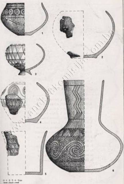
The most
common movable archaeological material consisted of pottery, finds of which are
the only real source for identifying the stages of development of the
settlement. The stratigraphic scale of the cultural stages generated from a
study of the pottery finds provides the following information:
Phase I:
from the subsoil to an average depth of 2.50 m (habitation horizons 1 and 2),
Phase II;
from an average depth of 2.50 m to an average depth of 1.00 m (habitation
horizons 3 to 5),
Phase
III: from an average depth of 1.00 m to the topmost surface of the settlement
(habitation horizons 6 to 8).
In all
three phase, the pottery was classified into two basic types: coarse and fine
pottery. All the pottery finds are stored in the National
Museum in Sarajevo. The coarse pottery of Phase I
consisted of thick-walled vessels, with poorly or thinly glazed surfaces and of
large size. The finer wares of Phase I consisted of several components –
Kakanj, Danilo, Lengyel-Pannonian, black-glazed and Butmiroid pottery.
In Phase
II, the pottery was somewhere between coarse and fine in quality. The walls of
these vessels are fairly thick, and the technique used is the same as for the
coarse wares, but the surface, especially on the outside, is more or less
glazed. There were considerable changes to the finer wares, with the Kakanj
elements (including the technique of making fine pottery) disappearing, along
with those of the Danilo culture (Ripoli-type painted wares, rhyta, incised
spirals) and Lengyel elements. The foreign elements typical of the area no
longer feature, merging into a single coherent Butmir culture. The Butmir
culture flourished during this phase, featuring its three basic components:
1)
black-glazed wares,
2)
spiral-banded pottery,
3)
Adriatic type pottery.
In Phase
III, where there were no major changes from the point of view of technology, a
standard process for the production of coarse pottery emerged. Unlike the two
previous stages, it is impossible here to draw the line between coarse and fine
pottery: most of the pottery wares were somewhere between the two, indicating a
decline in both technique and artistry. These wares include:
1)
black-glazed and grey-glazed pottery,
2) banded
pottery,
3)
Adriatic style pottery,
4)
Kostolac pottery and other kinds(12).
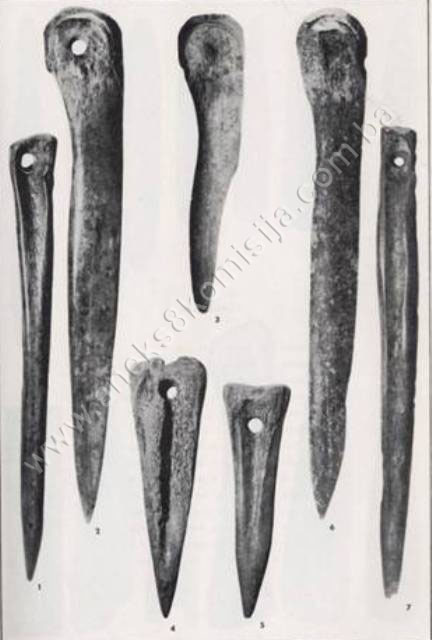
In
addition to pottery sherds, large quantities of stone artefacts were found at
Obre II: stable and large hand whetstones, grinding stones and various pestles,
hammer-heads, stone axes, flint tools (blades, scraper-blades, scrapers, awls
and arrowheads). The jewellery found consisted of decorative pins, necklaces of
wild boars’ teeth, jewellery made of spondylus shells, pottery rings and so on.
The
sculptural and relief artefacts found at Obre II fall into four groups:
a) human
figurines in the round
b) human
limbs in the round
c) animal
figurines in the round
d) human
figures on pottery(13).
These
findings revealed that the Butmir cultural group evolved into the three
chronological stages referred to above, Butmir I, II and III. The finds at Obre
II made it possible to determine the genesis of the Butmir culture on the basis
of a new and unambiguous picture of stratigraphic development. The chronological
relationships between the Butmir cultural group and other groups and complexes
also became clearer on the basis of the results of the excavations in Obre II,
details of which were published in a monograph on Obre II by Alojz Benac(14). Carbon 14 analysis conducted by
Marija Gimbutas established that the Neolithic settlement of Obre II was in
existence from 5310-4910 to 4780-4440 BCE(15).
Benac
found that the Kakanj culture also had three developmental stages, and that
Stage I of Obre II coincided in part with Stage III of the Kakanj culture,
indicating that the beginnings of the Butmir culture partly ran parallel with
the final stage of the Kakanj culture, the natural relationship between the
indigenous base and its cultural evolution from Kakanj III to Butmir I(16).
Further
studies of the Neolithic, not only at Obre II and elsewhere in Bosnia and Herzegovina but also in Europe, will no doubt provide ample further evidence of
the social structure of the settlements of the Butmir culture and its evolution.
3. Legal status to date
The
Regional Plan for BiH to 2000 listed the site of Obre II by the river
Trstionica near Obre I in Kakanj
Municipality as a
Category I monument of the late Neolithic period(17).
A letter
from Kakanj Municipality,
ref. 0-02/1-1438/09 of 11 May 2009 provided information from the planning
documentation of Kakanj
Municipality, in which
the archaeological site of Obre II is in a zone of detached residential
properties and is not subject to any special protection in the sense of
specific protection, identification and prohibitions on building. It also noted
that the municipality is currently drafting its Spatial and Town Plan and that
it will work with the Commission to Preserve National Monuments to identify the
site and ensure its adequate protection. Two applications for planning
permission for family houses in the zone in question have been received,
submitted by Hadžić Elmedin and Mujić Miralem. The municipality has undertaken
to suspend the granting of planning permissions until the boundaries of the
protected zone have been determined.
Under
cover of a letter from Kakanj
Municipality ref.
0-02/1-2733/09 of 24 August 2009, an excerpt was provided from a 1982 report by
Hamdija Kreševljaković, who had compiled it while working for the Institute for
the Protection of Monument. Page 5-c includes the words “Since archaeological
excavations have been carried out, no protection measures are required,” in
reference to Obre I and II.
A letter
from the Institute for the Protection of Monuments of the Federal Ministry of
Culture and Sport dated 16 June 2009 lists the site in the village of Obre,
Kakanj Municipality, under the heading:
-
Obre II, Gornje Polje, Obre, Kakanj. Prehistoric
settlement, Neolithic, area approx. 19-21.000 km², partly excavated.
The
property was not on the Register of Cultural Monuments of the Socialist
Republic of Bosnia and Herzegovina.
The
Institute also submitted an expert opinion in which it states that the site
merits adequate protection as a “treasure-house” with the greatest quantity of
data on the Neolithic culture and immense potential for further scientific
study.
4. Research and conservation and
restoration works
In 1958
the National Museum
embarked on a systematic field survey and information-gathering in order to
compile an archaeological map of Bosnia and Herzegovina. In 1961,
as part of this survey, the area of central Bosnia
from Kraljeva Sutjeska to Ćatići near Kakanj was surveyed, and the existence of
a sizeable Neolithic settlement was recorded at Gornje polje in the village of Obre. The first sondage was carried out
on the site in August 1973, and the next in July and August 1964.
The third sondage was conducted in July and August 1965, and the fourth
from 14 August to 30 September 1967.
In the
spring of 1968 borings were taken in the main directions in which the
settlement extended, confirming that the 1967 excavations had covered the
centre of the settlement and that further excavations should continue as in
1968. As a result, parallel excavations at Gornje polje and Raskršće were
carried out from 24 June to 18 August 1968.
No
conservation or restoration works have been carried out.
5. Current condition of the
property
The
findings of an on-site inspection at Obre II conducted on 13 August 2009
are as follows:
-
the central area of the
site is intact, with no works being carried out apart from agricultural
activities
-
access to the site is from
the right-hand side of the Ćatići – Kraljeva Sutjeska road, which also leads to
the neighbouring houses, but is not signposted
-
a water channel has been
dug in the northern part of the site, and there is evidence that efforts have
been made to begin digging the foundations for a house towards the central area
of the site
-
to the east is a brook,
the Bubanj, which flows below the terraced area to join the river Trstionica a
little further away from the site.
6. Specific risks
-
the greatest risk to the
site of Obre II, as to Obre I, is that the Spatial and Regulatory Plan for Kakanj Municipality
lists the site as one where permission may be granted to build detached houses
-
the peripheral areas of
the Neolithic settlement of Obre II have been jeopardized by the construction
of village houses, particularly since World War II
-
the archaeological site is
now endangered by efforts to build new houses and outbuildings.
III – CONCLUSION
Applying
the Criteria for the adoption of a decision on proclaiming an item of property
a national monument (Official Gazette of BiH nos. 33/02 and 15/03), the
Commission has enacted the Decision cited above.
The
Decision was based on the following criteria:
A. Time frame
B. Historical value
C. Artistic and aesthetic value
C.iv. composition
C.v. value of details
D. Clarity
(documentary, scientific and educational value)
D.i. material evidence of a lesser known
historical era
D.iv. evidence of a particular type, style or
regional manner
D.v. evidence of a typical way of life at a
specific period
E. Symbolic value
E.iii. traditional value
E.v. significance for the identity of a group of
people
F. Landscape value
F.iii. the building or group of buildings is part
of a group or site
G. Authenticity
G.i. form and design
G.ii. material and content
G.iii. use and function
G.iv. traditions and techniques
G.v. location and setting
H. Rarity and representativity
H.i. unique or rare example of a certain type
or style
I. Completeness
I.i. physical coherence
The
following documents form an integral part of this Decision:
-
Ownership documentation
-
Under ref. 0-02/1-2733/09
of 24.08.2009, Kakanj
Municipality provided the
following documentation: copy of cadastral plan on which the protected zone is
marked and with basic details of the cadastral plots, holders of the plots and
identification by the new and old surveys; statement by plot-holders; excerpt
from study by Hamdija Kreševljaković (1982)
-
Under ref 0-06/1-23-320/09
of 23.10.2009, the Department of Planning, Geodetics and Proprietary Rights
Affairs, Kakanj Municipality, submitted the following
documentation: copy of cadastral plan on which the protected zone is marked and
with basic details of the cadastral plots, holders of the plots and
identification by the new and old surveys for the wider area of Obre II
-
Under ref.
036-0-Rz-09-000737 of 28.12.2009, the Land Registry Office of the Court of
First Instance, Kakanj, provided the following Land Register entries: 13, 14,
331, 409, 516, 753, 781, 815, 905, 912, 1008, 1252, 1288, 1296, 1326, 1418,
1437, 1467, 1596, 1673 and 1682, c.m. SP Obre
-
Documentation on previous
protection of the property
-
Letter from Kakanj Municipality
ref. 0-02/1-2733/09 of 24.08.2009 including an excerpt from the study by
Hamdija Kreševljaković (1982)
-
Letter from the Institute
for the Protection of Monuments of the Federal Ministry of Culture and Sport
ref. 07-40-4-2348-1/09 of 16.06.2009
-
Letter from the Federal
Inspectorate Authority with official record no. 10/01-23-4-6087/09 of
14.05.2009
-
Letter from Kakanj Municipality
no. 0-02/1-1438/09 of 11.05.2209
-
Letter from the Institute
for the Protection of Monuments of the Federal Ministry of Culture and Sport
ref. 07-40-4-1480-1/08 of 24.04.2009
-
Photodocumentation
-
Photographs of the
property taken on 13.08.2009 by historian Zijad Halilović, using Canon EOS 450D
digital camera
-
Technical documentation
-
Identification of the
boundaries of the protected site, carried out in association with Mrs Zilka
Kujundžić-Vejzagić, archaeologist at the National
Museum in Sarajevo,
and Mrs Asima Bjelopoljak, representing Kakanj Municipality,
on 13.08.2009
-
Technical drawings of the
archaeological excavations and finds, from Benac, Alojz: “Obre II: Neolitska
naselje butmirske groupe na Gornjem polju” Sarajevo: Jnl of the National Museum of
Bosnia and Herzegovina (Archaeology) 26 (1971) 5-300
-
Aerophotogrammetric survey
of the current state of the site of Obre II, from Zilka Kujundžić-Vejzagić
Bibliography
During
the procedure to designate the monument as a national monument of Bosnia
and Herzegovina the following works were
consulted:
1971 Benac, Alojz. "Obre II: Neolitsko naselje butmirske grupe
na Gornjem polju" (Obre II: a Neolithic Settlement of the Butmir Group at
Gornje Polje). Sarajevo: Jnl of the National Museum of Bosnia and Herzegovina (Archaeology)
26 (1971)
1973 Benac, Alojz. "Obre I: Neolitsko naselje
starčevačko-impresso i kakanjske kulture na Raskršu" (Obre I: a Neolithic
settlement of the Starčevo-Impresso and Kakanj Culture at Raskrše). Sarajevo: Jnl of the National Museum of Bosnia and
Herzegovina (Archaeology) 27/28 (1973)
1974 Gimbutas, Marija. "Chronology of Obre
I and Obre II". Sarajevo:
Wissenschaftliche Mitteilungen des Bosnisch-Herzegowinischen Landesmuseums 4,
heft A, Archäologie (1974)
1980 Various authors. Prostorni plan
Bosne i Hercegovine, faza b – valorizacija, prirodne i kulturno-historijske
vrijednosti (Regional Plan for BiH, stage b – valorization of natural, cultural
and historical values). Sarajevo: Institute for Architecture, Town and Country
Planning of the Faculty of Architecture in Sarajevo and the Planning Authority
of Bosnia and Herzegovina, Sarajevo, 1980
1988 Marjanović, Brunislav. “Neolitsko doba”. Sarajevo: Arheološki leksikon, 1988
(The Neolithic Period, Archaeological Lexicon)
1988 Marjanović, Brunislav. “Eneolitsko doba”. Sarajevo: Arheološki leksikon, 1988
(The Eneolithic Period, Archaeological Lexicon)
(1) For more
extensive historical background, see the decision of the Commission
designating the archaeological site of the Zelena (Green) cave, a prehistoric
cave habitation in Blagaj, City of Mostar, as a national monument of Bosnia
and Herzegovina, no. 05.1-2-135/07-5 of 21 November 2007, Sarajevo
(2) Marjanović,
Brunislav, “Neolitsko doba,” in Arheološki leksikon, Sarajevo: National Museum of Bosnia and
Herzegovina. 1988, 18.
(3) Marjanović,
Brunislav, “Eneolitsko doba,” in Arheološki leksikon, Sarajevo: National Museum of Bosnia and
Herzegovina. 1988, 20.
(4) Benac,
Alojz, “Obre II, neolitsko naselje butmirske grupe na Gornjem polju,” Sarajevo: Jnl of the
National Museum, Arch. n.s. vol.. XXVI, 1971, 9.-12.
(5) The results
of the excavations of the site were published by A. Benac with the title “Obre I
– Neolitsko naselje starčevačko-impresso i kakanjske kulture na Raskršću,” Sarajevo: Jnl Nat Mus
n.s. Arch, XXVII–XVIII, 1972–1973, 5–171, + figs. 1–3 and 9.
(6) Benac,
Alojz, “Obre II, neolitsko naselje butmirske grupe na Gornjem polju,” Sarajevo: Jnl of the
National Museum, Arch. n.s. vol.. XXVI, 1971, 5.-8.
(7) Benac,
Alojz, op.cit., 1971, 9-10
(8) Benac,
Alojz, op.cit., 1971, 12-13
(9) Benac,
Alojz, op.cit., 1971, 16-17
(10) Benac,
Alojz, op.cit., 1971, 19, 29, 35, 36, 39, 57, 58
(11) Benac,
Alojz, op.cit., 1971, 58, 60-81
(12) Benac,
Alojz, op.cit., 1971, 105-138
(13) Benac,
Alojz, op.cit., 1971, 81-105
(14) Benac,
Alojz, op.cit., 1971, 169
(15) Gimbutas, Marija,
Chronology of Obre I and Obre II, Sarajevo: Wissenschaftliche mitteilungen
des Bosnisch-Herzegowinischen Landesmuseum, IV, heft A, Archälogie, 1974, 15.-35.
(16) Benac,
Alojz, op.cit., 1971, 169
(17) Various
authors, Prostorni plan Bosne i Hercegovine, faza b – valorizacija, prirodne
i kulturno-historijske vrijednosti, Sarajevo: Institute for Architecture,
Town and Country Planning of the Faculty of Architecture in Sarajevo and
Planning Authority of Bosnia and Herzegovina, Sarajevo: 1980, 34.
|