Status of monument -> National monument
Published in the “Official Gazette of BiH”,
no. 94/09.
Pursuant to Article V para. 4 Annex 8 of the
General Framework Agreement for Peace in Bosnia and Herzegovina and Article 39
para. 1 of the Rules of Procedure of the Commission to Preserve National
Monuments, at a session held from 7 to 13 July 2009 the Commission adopted a
D E
C I S I O N
I
The
historic site of the necropolis with stećak tombstones at Crkvina (Pod) and the
remains of the foundations of a mediaeval building, Donja Drežnica (Jasenjani),
City of Mostar, is hereby designated as a National Monument
of Bosnia and Herzegovina (hereinafter: the National Monument).
The National Monument consists of a
necropolis with 17 stećak tombstones (chest-shaped and slabs) and the remains
of the foundations of a mediaeval building.
The National Monument is located on a site
designated as cadastral plot no. 599/1, title deed nos. 36 and 180, Land
Register entry no. 383, cadastral municipality Jasenjani, City of Mostar,
Federation of Bosnia and Herzegovina, Bosnia and Herzegovina.
The provisions relating to protection
measures set forth by the Law on the Implementation of the Decisions of the
Commission to Preserve National Monuments, established pursuant to Annex 8 of
the General Framework Agreement for Peace in Bosnia and Herzegovina (Official
Gazette of the Federation of BiH nos. 2/02, 27/02, 6/04 and 51/07) shall apply
to the National Monument.
II
The Government of the Federation of Bosnia
and Herzegovina (hereinafter: the Government of the Federation) shall be
responsible for providing the legal, scientific, technical, administrative and
financial measures necessary for the protection, conservation and presentation
of the National Monument.
The Commission to Preserve National Monuments
(hereinafter: the Commission) shall determine the technical requirements and
secure the funds for preparing and erecting signboards with basic details of
the monument and the Decision to proclaim the property a National Monument.
III
To ensure the on-going protection of the National Monument on the site defined in
Clause 1 para. 3 of this Decision:
-
all works are
prohibited other than conservation and restoration works, including those
designed to display the monument, with the approval of the Federal Ministry
responsible for regional planning (hereinafter: the relevant ministry) and
under the expert supervision of the heritage protection authority of the
Federation of Bosnia and Herzegovina (hereinafter: the heritage protection
authority).
The Government of the Federation shall be
responsible in particular for:
-
conducting a geodetic
survey and survey of the condition of the site
-
drawing up a project
for the repair, restoration and conservation of the necropolis.
The repair, restoration and conservation
project shall cover:
-
clearing lichen and
moss from the stećak tombstones and making good any damage
-
tidying the site and
clearing it of self-sown vegetation
-
drawing up and
implementing a programme for the presentation of the National Monument.
IV
All executive and area development planning
acts not in accordance with the provisions of this Decision are hereby revoked.
V
Everyone, and in particular the competent
authorities of the Federation of Bosnia and Herzegovina, the Canton, and urban
and municipal authorities, shall refrain from any action that might damage the
National Monument or jeopardize the preservation thereof.
VI
The Government of the Federation, the Federal
Ministry responsible for regional planning, the Federation heritage protection
authority, and the Municipal Authorities in charge of urban planning and land
registry affairs, shall be notified of this Decision in order to carry out the
measures stipulated in Articles II to V of this Decision, and the Authorized
Municipal Court shall be notified for the purposes of registration in the Land
Register.
VII
The elucidation and accompanying
documentation form an integral part of this Decision, which may be viewed by
interested parties on the premises or by accessing the website of the
Commission (http://www.aneks8komisija.com.ba)
VIII
Pursuant to Art. V para 4 Annex 8 of the
General Framework Agreement for Peace in Bosnia and Herzegovina, decisions of
the Commission are final.
IX
This Decision shall enter into force on the
day following its publication in the Official Gazette of BiH.
This Decision has been adopted by the
following members of the Commission: Zeynep Ahunbay, Martin Cherry, Amra
Hadžimuhamedović, Dubravko Lovrenović, and Ljiljana Ševo.
No.
05.1-2-40/09-37
8
July 2009
Sarajevo
Chair
of the Commission
Amra
Hadžimuhamedović
E l
u c i d a t i o n
I – INTRODUCTION
Pursuant to Article 2, paragraph 1 of the Law
on the Implementation of the Decisions of the Commission to Preserve National
Monuments, established pursuant to Annex 8 of the General Framework Agreement
for Peace in Bosnia and Herzegovina, a “National Monument” is an item of public
property proclaimed by the Commission to Preserve National Monuments to be a
National Monument pursuant to Articles V and VI of Annex 8 of the General
Framework Agreement for Peace in Bosnia and Herzegovina and property entered on
the Provisional List of National Monuments of Bosnia and Herzegovina (Official
Gazette of BiH no. 33/02) until the Commission reaches a final decision on its
status, as to which there is no time limit and regardless of whether a petition
for the property in question has been submitted or not.
On 24 February 2008 Emir Šehić of Sarajevo
submitted a proposal to designate the historic site of the necropolis with
stećci at Crkvina, Donja Drežnica, City of Mostar, as a national monument of
Bosnia and Herzegovina.
Pursuant to the provisions of the law, the
Commission proceeded to carry out the procedure for reaching a final decision
to designate the Property as a National Monument, pursuant to Article V para. 4
of Annex 8 and Article 35 of the Rules of Procedure of the Commission to
Preserve National Monuments.
Statement of Significance
The monument consists of a necropolis with 17
stećak tombstones and the remains of the foundations of a mediaeval building
the outlines of which are typical of a church (though it is unlikely that a
church would have the entrance at the east end and the apse at the west end)
has been recorded at Crkvina (Pod), on the left bank of the river Neretva,
about 300 m downstream from its confluence with the Drežanka, in Donja Drežnica
(Jasenjani). One stećak is decorated with a circular garland in relief.
The mediaeval building is similar in plan to
a church, and lies east-west, but with the entrance at the east end and a
semicircular apse at the west end. Its size, plan and architectural features
suggest that it dates from the late mediaeval period, and that it could have
been built in the 14th century and demolished in the 15th.
II – PROCEDURE PRIOR TO
DECISION
In the procedure preceding the adoption of a
final decision to proclaim the property a national monument, the following
documentation was inspected:
-
Documentation on the
location and the current owner and user of the property (copy of cadastral plan
and Land Register entry),
-
Details of the
current condition and use of the property, including a description and
photographs, data of war damage, data on restoration or other works on the
property, etc.
-
Historical,
architectural and other documentary material on the property, as set out in the
bibliography forming part of this Decision.
The findings based on the review of the above
documentation and the condition of the site are as follows:
1. Details of the property
Location
The necropolis with stećci and the remains of
the foundations of a mediaeval building at Crkvina (Pod) is at an altitude of
131 m above sea level, latitude 43° 30.810' and
longitude 17° 44.703', on the left bank of the river
Neretva, about 300 m downstream from the confluence of the Drežanka.
The National Monument is located on a site
designated as cadastral plot no. 599/1, title deed nos. 36 and 180, Land
Register entry no. 383, cadastral municipality Jasenjani, City of Mostar,
Federation of Bosnia and Herzegovina, Bosnia and Herzegovina.
Historical
information
In mediaeval times the Drežnica
area, about which the historical records are very meagre, covered the Drežanka
valley, Čvrsnica and the plain between Mts Čvrsnica and Vran. In the 1320s it
became part of the Bosnian state.(1) In
1357 the western regions of Hum, including Drežnica, came into the possession
of Hungary’s King Louis I [the Great, of the Angevin dynasty, 1342-1382] as the
dowry of his wife Jelisaveta, daughter of Stjepan Kotromanić, uncle of Ban,
later King Tvrtko I.
The landed Mesnović clan, vojvoda [duke/dux, military leader]
Mastan Bubanjić and his heirs lived in Donja Drežnica. Mastan Bubanjić's
inscription [engraved on a rock face in a place known as Toplo in Donja
Drežnica], which can be roughly dated to the reign of King Louis and Bosnia's
ban Tvrtko, 1356 to 1366, refers to Mastan's sons Radoslav and Miroslav(2); in 1381 Radoslav became a Ragusan noble.(3)
The inscription refers to the court of the
Hum vojvoda Mes[te]n, who was not believed to be the same as the Bosnian knez [prince, earl] Mastan Bubanjić who
featured as a witness to charters issued by ban Tvrtko Kotromanić in 1354 and
1355. The spelling of the first name, Mesten, and the surname Mesnović for his
son Radoslav, feature in written sources from Dubrovnik dating from 1381 and 1382.(4)
A number of charters name knez Priboje
Masnović as witness. A charter issued by Tvrtko in Trstivnica on 10 April 1380
reveals that among the nobles in the king’s retinue was knez Priboje Masnović. He
again features as a witness in a charter of 2 April 1394 by which Stjepan
Dabiša, king of Bosnia, granting some land to Gojko Marnavić, and in another of
17 May 1395, in which King Stjepan Dabiša granted the village of Kolo to one
Vukmor and his brothers. Charters issued by King Stjepan Ostoja where Priboje
Masnović features as a witness include one of 15 January 1399 in which the king
cedes Bosansko Primorje, the coastal region, to the Ragusans, and another of 5
February 1399 in which the king reaffirms certain privileges accorded to the
Ragusans. It is not known exactly who this Priboje was, but he could have been
one of Mastan’s sons(5). He
features in known charters from 1378 to 1399, always as knez, a title he could
have acquired on the basis of his father’s rank, since then as later it was the
custom for a vojvoda’s son to bear the title of knez. Mastan was already
vojvoda well before 1378, so if Priboje was his son, he could have been knez by
then.(6)
It would seem that Mastan and his heirs,
known after him as Masnović by surname, were of high standing in their time;
certainly they had their own armorials.
The
earliest reference to Drežnica dates from the early 14th century, in a charter
of King Ostoja, the terms of which included granting the “provincia” of
Drežnica to the Radivojević brothers. At that time Drežnica had the status of
an administrative entity equal to Blato or Broćno.(7)
The ubication of the župa (county) of Večenike-Večerić is one of the most challenging
problems in the historical topography of mediaeval Hum, yet without solving it,
it is impossible to understand many important questions in the history of Hum
over a long period, from the 9th to the 15th century.(8)
The earliest reference to the county is in
the Chronicle of the Doclean Pope,
the final redaction of which was completed around the mid 12th century. It
lists the župas (županijas) in Hum land in the following order: Ston, Popovo,
Žapska, Luka, Velika, Gorimita, Večenike, Dubrave and Dabar. This list provides
three basic items of information: the existence of a county named Večenike, the
fact that it belonged to Hum and, indirectly, some clues to its territorial
extent (bordering Luka county to the south, Velika county to the south-west,
Imota to the west, Rama and Neretva to the north, Kama and Nevesinje to the
north-east, and Bišće and Dubrave to the east).(9)
Drežnica is an isolated area of a number of
villages in the karst valley between Mts Čvrsnica and Čabulja. Though small in
extent and population, it often enjoyed a certain administrative and political
autarchy on account of its geographical isolation. In the early 15th century it
was equal in status as an administrative entity to Blato or Broćno, and in the
very early days of the Ottoman period, on account of its specific circumstances,
Drežnica briefly became a nahija
[minor administrative entity] alongside the Mostar nahija; from the mid 15th
century, still as a nahija, it formed an integral part of the Mostar kadiluk [area under the jurisdiction of
a kadi](10). From the latter half of the 16th right
through to the 19th century the Mostar kadiluk covered the nahijas of Mostar,
Broćno, Blato and Drežnica.
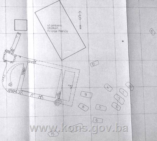
2. Description of the
property
Seventeen stećci have been recorded in the
necropolis, lying east-west (though stećak no. 13 is off true). The only stećci
of which the form can be identified with certainty are five tall chests; some
of the stećci are so deeply sunk into the ground or damaged that it is
impossible even to say if they are chest-shaped or slabs. Two(11) or three(12) were
decorated (relief motifs: a circular garland and a frieze of zigzag lines, the
figure of a man with a sword and shield, and a deer-hunting scene).
Excavation of the graves provided no movable
artefacts that might date them more accurately. The graves were made of stone
slabs forming a rectangle narrowing toward the feet, and were covered by one or
more slabs. The head of the deceased was at the west end.
Stećak no. 1,
slab, measuring 176 x 60 x 15 cm, of wholly indeterminate shape.
Stećak no.2,
measuring 98 x 60 x 16 cm, in a very poor state of preservation, broken.
Stećak no. 3,
chest, measuring 175 x 74 x 33 cm, in a very poor state of preservation,
chipped.
Stećak no. 4,
measuring 148 x 96 x 25 cm, in a poor state of preservation, chipped.
Stećak no. 5,
measuring 182 x 95 x 30 cm, in a poor state of preservation, chipped, leaning,
partly buried, overgrown with vegetation.
Stećak no. 6,
measuring 163 x 80 x 25 cm, in a poor state of preservation, top surface
cracked, overgrown with vegetation.
Stećak no. 7,
measuring 190 x 105 x 28 cm, in a very poor state of preservation, top surface
cracked, partly buried, overgrown with vegetation.
Stećak no. 8,
completely overgrown with low-growing and tall vegetation.
Stećak no. 9,
chest, measuring 177 x 83 x 35 cm, in a very poor state of preservation,
flaking, cracked.
Stećak no. 10,
measuring 250 x 128 x 28 cm, in a poor state of preservation, overgrown with
vegetation.
Stećci no. 11 and
12, completely overgrown with
low-growing and tall vegetation.
Stećak no. 13,
tall chest, measuring 162 x 110 x 65 cm, oriented north-east/south-west, in a
poor state of preservation, overgrown with vegetation, cracked.
Stećak no. 14,
tall chest, measuring 198 x 85 x 60 cm, top surface beginning to crack, overgrown
with vegetation.
Stećak no. 15,
tall chest, measuring 158 x 72 x 66 cm, decorated with a circular garland in
relief on the west end.
Stećak no. 16,
tall chest, measuring 177 x 103 x 60 cm, overgrown with vegetation.
Stećak no. 17,
tall chest, measuring 180 x 105 x 60 cm, overgrown with vegetation.
Archaeological excavations at Crkvina
uncovered the foundations of a building that Atanacković-Salčić assumed were
the remains of a church or chapel
measuring 13.30 x 6.80 m(13). The
foundations, which were covered by a thin layer of stones and soil and
overgrown with trees, were in the grounds of a village house(14). Before excavations began in the grounds,
which measured 30 x 15 m, there were no visible signs of a building other than
some dressed stone on the surface. Soundings in quadrants D-3 and D-4 revealed
evidence of a wall with lime mortar at a depth of only 40 cm. East of the
building were 13 stećci, covered with soil and overgrown with trees. The
building consisted of a single space measuring 6 x 5.45 m. The entrance area
was not properly excavated, and part had been destroyed when a well or cistern
was dug. It seems likely, however, that there was a small parvis, measuring
5.45 x 1.80 m, outside the entrance to the nave(15). The
building lay east-west, with the entrance at the east end and a semicircular
apse at the west end, and measured 5 x 2.50 m. The apse was divided from the
nave by a partition wall 60 cm thick. A small walled area of laid stone and
large slabs had been built by the north-west part of the apse. Adjoining this
was a wall running north, the purpose of which is not known(16). The foundation walls were built of large
river pebbles and dressed stone with lime mortar (with a fairly high proportion
of sand), above which the walls were of sizeable, neatly dressed stone blocks. Judging
from the way it was built, its architectural features, and the size of the
building, Atanacković-Salčić suggested that even so it was probably a church
dating from the later mediaeval period, built in the 14th century and
demolished in the 15th(17). It
is not possible to say with certainty whether the church was burned down or
pulled down. A layer of black earth was found in the entire cultural layer
above floor level, and there was a heap of soot outside the south wall of the
church, in which the head of a mediaeval spear was found. The remains of a
plaster floor and part of the wall plaster with a thickness of 3 cm were found
in the north-west corner. There were no surviving traces of frescoes.
3. Legal status to date
For
some time the Regional Institute for the Protection of Cultural Monuments and
Nature in Mostar carried out protective works on cultural monuments, thanks to
the hydro power plant on the Neretva at Jablanica which allocated funds for the
works. In the first phase, the large necropolis with stećci in Raška Gora near
Mostar was investigated, in 1977. The second phase began in September and
October 1979, and covered two archaeological sites in Drežnica and Donji Jasenjani.
The Regional Plan for BiH to 2000 lists 69
sites of necropolises with stećci (1208 tombstones) in the City of Mostar area
as Category III monuments, without precisely identifying them.
The property is not on the Provisional List
of National Monuments of the Commission to Preserve National Monuments; this
Decision is rendered on the basis of the petition referred to above.
4. Research and conservation
and restoration works
In the 1950s
the management of the National Museum in Sarajevo began the systematic
investigation of necropolises with stećci in Bosnia and Herzegovina.
In an article in the Annual of the Historical Society of BiH, Š. Bešlagić states that
there is a necropolis with about twenty stećci, quite damaged and partly
buried, 300 m downstream from the confluence of the Drežanka and the Neretva,
on an area of level ground between the road and the Neretva. Just across the
road, on a small hillock, is another group of a number of chest-shaped
tombstones. This means that the road cut through the necropolis(18). (Š.
Bešlagić, 1955, 71).
He also states that there is a necropolis
with twenty chest-shaped stećci lying east-west and the remains of an old
building, probably a church, at Crkvina, also known as Pod, on the left bank of
the Neretva.(19)
Vol. III of the Archaeological Lexicon lists Crkvina (Pod), Donji Jasenjani,
Mostar, where there are the remains of a mediaeval church and necropolis. The
excavations were carried out by V. Atanacković-Salčić in 1979-1981, uncovering
the foundations of a church measuring 13.30 x 6.80 m, lying east-west, and a
necropolis with 17 slab-shaped and chest-shaped stećci; six graves constructed
from stone slabs were excavated. Date: late mediaeval.(20)
5. Current condition of the
property
The findings of an on-site inspection
conducted on 26 June 2009 are as
follows:
-
the necropolis is
completely overgrown with tall grass and scrub, and it was not possible to
determine the exact number of stećci(21),
-
the condition of the
necropolis made it impossible to measure three of the stećci or to identify the
basic shape of each tombstone (partly buried, of indeterminate shape),
-
plant organisms which
are destroying the structure of the stone are present on most of the stećci,
-
17 visible stećci
were recorded,
-
the stećci are in
poor condition (cracked, damaged, chipped, flaking),
-
the remains of the
foundations of the mediaeval building are completely overgrown with tall scrub
and grass, and only the exterior conserved outlines of the walls can be made out.
6. Specific risks
-
long-term neglect of
the site,
-
adverse weather
conditions,
-
self-sown vegetation.
III – CONCLUSION
Applying the Criteria for the adoption of a
decision on proclaiming an item of property a national monument (Official
Gazette of BiH nos. 33/02 and 15/03), the Commission has enacted the Decision
cited above.
The Decision was based on the following
criteria:
A. Time
frame
B. Historical
value
C. Artistic
and aesthetic value
C.iii.
proportions
C.v.
value of details
E. Symbolic
value
E.
v. significance for the identity of a
group of people
G. Authenticity
G.iii.
use and function
G.iv.
traditions and techniques
The following documents form an integral part
of this Decision:
-
Copy of cadastral
plan
-
Copy of land register
entry
-
Photodocumentation,
11 photographs taken on site
Bibliography
During the procedure to designate the
property as a national monument of Bosnia and Herzegovina the following works
were consulted:
1955. Bešlagić, Šefik. “Mastan Bubanjić,” Annual of the Historical Society of Bosnia
and Herzegovina. Sarajevo: 1955.
1971. Bešlagić, Šefik. Stećci, kataloško-topografski pregled (Stećci, a Catalogue and
Topographical Overview). Sarajevo: 1971.
1980. Atanacković – Salčić. Arheološki pregled 21 (Archaeological Survey 21). Belgrade: 1980.
1982. Anđelić, Pavao. Studije o teritorijalnopolitičkoj organizaciji srednjovjekovne Bosne
(Study of the Territorial and Political Organization of Mediaeval Bosnia).
Sarajevo: Svjetlost, 1982.
1982. Anđelić, Pavao. “Mesnovići, Masnovići,
Bubanjići – humska i bosanska vlastela” (Mesnovići, Masnovići, Bubanjići – Hum
and Bosnian landed nobility), offprint from the periodical Hercegovina, no. 2/1982, Mostar, 1982.
1983. Niškanović, Miroslav. “Porijeklo
stanovništva Drežnice” (Origins of the Population of Drežnica), Jnl of the National Museum in Sarajevo,
Ethnology. Sarajevo: 1983.
1988. Čović, Borivoj (ed.). Arheološki leksikon Bosne i Hercegovine (Archaeological Lexicon of
BiH), vol. 3, National Museum in Sarajevo. Sarajevo: 1988.
2009. Lovrenović, Dubravko. Stećci. Sarajevo: Rabic, 2009.
(1) Šefik Bešlagić, “Mastan
Bubanjić,” Annual of the History Society
of Bosnia and Herzegovina, Sarajevo: 1955, 67
(2) For more on Mastan Bubanjić, see the
decision designating the cultural
landscape with Mastan Bubanjić's inscription in Donja Drežnica near Mostar as a
national monument of Bosnia and Herzegovina (no. 05.1-2-309/05-6 of 17 May
2006 and the Commission's web site, www.aneks8komisija.com.ba
(3) Šefik Bešlagić, op.cit., 1955, 74
(4) Dubravko Lovrenović, Stećci, Sarajevo: Rabic, 2009, 96
(5) Šefik Bešlagić, op.cit., 1955, 75
(6) Idem, 75
(7) Miroslav Niškanović, “Porijeklo
stanovništva Drežnice,” in Jnl of the
National Museum in Sarajevo, ethnology, Sarajevo, 1983, 4
(8) Pavao Anđelić, Studije o teritorijalnopolitičkoj organizaciji srednjovjekovne Bosne,
Sarajevo: Svjetlost, 1982, 117-119
(9) These are basically the areas of
Čitluk, Lištica (Široki Brijeg) and Mostar (City of Mostar) municipalities, in
the older nomenclature they are Broćno, Blato and the environs of Mostar (with
Bijelo polje and Drežnica) (Anđelić, 1982, 135)
(10) Pavao Anđelić, op.cit., 1982, 137
(11) According to Š. Bešlagić (Bešlagić,
1971, 338)
(12) According to V. Atanacković-Salčić (.Atanacković-Salčić,
1980, 154)
(13) Atanacković-Salčić, in Arheološki pregled 21, Belgrade: 1980,
153
(14) “...the property of Franjo Perić.”
(Atanacković-Salčić, op.cit., 1980, 153).
(15) Atanacković-Salčić, op.cit., 1980, 153
(16) “This northern part was
probably demolished when F. Perić's house was built.” (Atanacković-Salčić,
op.cit., 1980, 153).
(17) Atanacković-Salčić, op.cit., 1980, 153
(18) Šefik Bešlagić, op.cit., 1955, 71
(19) Šefik Bešlagić, Stećci, kataloško-topografski pregled, Sarajevo: 1971, 338
(20) Borivoj Čović (ed..), Arheološki leksikon Bosne i Hercegovine,
Vol. III, Sarajevo: 1988, 294
(21) The text of the
Decision shows that Š. Bešlagić refers to about 20 stećci and
Atanacković-Salčić to 17 (a total of 17 were recorded on the site)
|