Status of monument -> National monument
Published in the “Official Gazzete of BiH” no. 36/09.
Pursuant to Article V para. 4 Annex 8 of the General Framework Agreement for Peace in Bosnia and Herzegovina and Article 39 para. 1 of the Rules of Procedure of the Commission to Preserve National Monuments, at a session held from 20 to 26 January 2009 the Commission adopted a
D E C I S I O N
I
The historic site of the necropolis with stećak and old nišan tombstones in Budoželje, Municipality Vareš, is hereby designated as a National Monument of Bosnia and Herzegovina (hereinafter: the National Monument).
The National Monument consists of:
a) a necropolis with 36 stećak tombstones at Glavica (Hrid),
b) three nišan tombstones at Gromile,
c) a necropolis with 30 stećak tombstones and about 20 old nišan tombstones at Višgreblje (Jabuka),
d) a necropolis with twelve stećak tombstones at Solila (Trzan),
e) a necropolis with two stećak tombstones at Vrh.
The National Monument is located on a site designated as cadastral plot no. 14/1 (old survey), corresponding to c.p. no. 265/1 (new survey), title deed no. 100, Land Register entry no. 71, c.p. no. 274/3 (old survey), corresponding to c.p. no. 260/2 (new survey), title deed no. 351, Land Register entry no. 474, c.p. no. 274/2 (old survey), corresponding to c.p. no. 256/7 (new survey), title deed no. 366, Land Register entry no. 113, c.p. no. 287 (old survey), corresponding to c.p. no. 1989 (new survey), title deed no. 120, Land Register entry no. 71, part of plot c.p. no. 286/1 (old survey), corresponding to c.p. no. 1986 (new survey), title deed no. 237, Land Register entry no. 96, part of plot c.p. no. 285 (old survey), corresponding to c.p. no. 1988 (new survey), title deed no. 120, Land Register entry no. 143, c.p. no. 289/1, (old survey), Land Register entry no. 150, and c.p. no. 289/2, 289/3, 289/4, (old survey), Land Register entry no. 147, corresponding to c.p. no. 1991 and 1992, (new survey), title deed no. 97, part of c.p. no. 394/2 (old survey), corresponding to c.p. no. 957 (new survey), title deed no. 315, Land Register entry no. 108, part of c.p. no. 397 (old survey), corresponding to c.p. no. 2406 (new survey), title deed no. 95, Land Register entry no. 71, part of c.p. no. 402 (old survey), corresponding to c.p. no. 981 (new survey), title deed no. 104, Land Register entry no. 221, and part of c.p. no. 403 (old survey), corresponding to c.p. no. 981 (new survey), title deed no. 104, Land Register entry no. 313, cadastral municipality Budoželje, Municipality Vareš, Federation of Bosnia and Herzegovina, Bosnia and Herzegovina.
The provisions relating to protection measures set forth by the Law on the Implementation of the Decisions of the Commission to Preserve National Monuments, established pursuant to Annex 8 of the General Framework Agreement for Peace in Bosnia and Herzegovina (Official Gazette of the Federation of BiH nos. 2/02, 27/02, 6/04 and 51/07) shall apply to the National Monument.
II
The Government of the Federation of Bosnia and Herzegovina (hereinafter: the Government of the Federation) shall be responsible for providing the legal, scientific, technical, administrative and financial measures necessary for the protection, conservation and presentation of the National Monument.
The Commission to Preserve National Monuments (hereinafter: the Commission) shall determine the technical requirements and secure the funds for preparing and erecting signboards with basic details of the monument and the Decision to proclaim the property a National Monument.
III
To ensure the on-going protection of the National Monument on the site defined in Clause 1 para. 3 of this Decision, the following protection measures are hereby stipulated:
- all works are prohibited other than conservation and restoration works, including those designed to display the monument, with the approval of the Federal Ministry responsible for regional planning (hereinafter: the relevant ministry) and under the expert supervision of the heritage protection authority of the Federation of Bosnia and Herzegovina (hereinafter: the heritage protection authority);
- the site of the monument shall be open and accessible to the public, and may be used for educational and cultural purposes;
- works on the infrastructure are prohibited except with the approval of the relevant ministry and subject to the expert opinion of the heritage protection authority;
- all building or other works that could have the effect of altering the area are prohibited, as is the erection of temporary facilities or permanent structures not designed solely for the protection and presentation of the National Monument;
- burials within 15 metres of the stećak tombstones are prohibited;
- burials within 5 metres of the nišan tombstones are prohibited;
- the dumping of waste is prohibited.
The Government of the Federation shall be responsible in particular for drawing up a project for the repair, restoration and conservation of the necropolis.
The repair, restoration and conservation project shall cover:
- archaeological investigations;
- clearing lichen and moss from the stećak and nišan tombstones and making good any damage;
- tidying the site and clearing it of self-sown vegetation;
- drawing up and implementing a programme for the presentation of the National Monument.
IV
All executive and area development planning acts not in accordance with the provisions of this Decision are hereby revoked.
V
Everyone, and in particular the competent authorities of the Federation of Bosnia and Herzegovina, the Canton, and urban and municipal authorities, shall refrain from any action that might damage the National Monument or jeopardize the preservation thereof.
VI
The Government of the Federation, the Federal Ministry responsible for regional planning, the Federation heritage protection authority, and the Municipal Authorities in charge of urban planning and land registry affairs, shall be notified of this Decision in order to carry out the measures stipulated in Articles II to V of this Decision, and the Authorized Municipal Court shall be notified for the purposes of registration in the Land Register.
VII
The elucidation and accompanying documentation form an integral part of this Decision, which may be viewed by interested parties on the premises or by accessing the website of the Commission (http://www.aneks8komisija.com.ba)
VIII
Pursuant to Art. V para 4 Annex 8 of the General Framework Agreement for Peace in Bosnia and Herzegovina, decisions of the Commission are final.
IX
This Decision shall enter into force on the day following its publication in the Official Gazette of BiH.
This Decision has been adopted by the following members of the Commission: Zeynep Ahunbay, Martin Cherry, Amra Hadžimuhamedović, Dubravko Lovrenović, and Ljiljana Ševo.
No: 02-02-40/09-2
21 January 2009
Sarajevo
Chair of the Commission
Dubravko Lovrenović
E l u c i d a t i o n
I – INTRODUCTION
Pursuant to Article 2, paragraph 1 of the Law on the Implementation of the Decisions of the Commission to Preserve National Monuments, established pursuant to Annex 8 of the General Framework Agreement for Peace in Bosnia and Herzegovina, a “National Monument” is an item of public property proclaimed by the Commission to Preserve National Monuments to be a National Monument pursuant to Articles V and VI of Annex 8 of the General Framework Agreement for Peace in Bosnia and Herzegovina and property entered on the Provisional List of National Monuments of Bosnia and Herzegovina (Official Gazette of BiH no. 33/02) until the Commission reaches a final decision on its status, as to which there is no time limit and regardless of whether a petition for the property in question has been submitted or not.
In 17 September 2008 Vareš Municipality submitted a proposal/petition to designate the necropolises of stećak tombstones in the village of Budoželje (necropolis at Hrid-Glavica and two groups of 21 + 13 stećak tombstones) as a national monument of Bosnia and Herzegovina.
Pursuant to the provisions of the law, the Commission proceeded to carry out the procedure for reaching a final decision to designate the Property as a National Monument, pursuant to Article V para. 4 of Annex 8 and Article 35 of the Rules of Procedure of the Commission to Preserve National Monuments.
Statement of Significance
The national monument consists of eighty stećak tombstones and twenty old nišan tombstones on four sites close to the village of Budoželje near Vareš, an area historically rich in natural resources. The mediaeval tombstones known as stećci (pl. of stećak) are unique to Bosnia and Herzegovina and its neighbouring countries. They provide impressive evidence of the growing economic power of Bosnian feudal society in the 14th century, the opening of mines, increasing urbanization, and the wish of individuals to display their status and power through the appearance of their tombstones. Most of the tombstones at these sites were made of local stone, and are chest-shaped and fairly even in shape. A few are decorated with realistic and symbolic designs (human and animal figures, an animal and a moon, a hand with a sword, and two crescent moons touching back-to-back). The nišans, many of which are surmounted by a distinctive turban or fez, date mainly from the 18th and 19th century. They feature the decorative motifs of a moon and sabre, and two bear epitaphs.
II – PROCEDURE PRIOR TO DECISION
In the procedure preceding the adoption of a final decision to proclaim the property a national monument, the following documentation was inspected:
- Documentation on the location and the current owner and user of the property (copy of cadastral plan and Land Register entry),
- Details of the current condition and use of the property, including a description and photographs, data of war damage, data on restoration or other works on the property, etc.
- Historical, architectural and other documentary material on the property, as set out in the bibliography forming part of this Decision.
The findings based on the review of the above documentation and the condition of the site are as follows:
1. Details of the property
Location
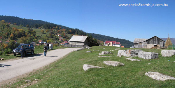
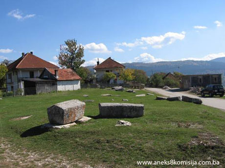
The village of Budoželje (44°04'50.88" N, 18°20'17.14" E)(1) is about 10 km as the crow flies to the south-east of Vareš. Four sites in the village and environs have been identified where there are necropolises with stećci (plural of stećak) and old nišan tombstones. A necropolis with 36 stećci (34 chest-shaped and two gabled) is located in the middle of the village, at a place known as Glavica or Hrid. About 30 m to the north of the necropolis, at Gromile, are three old nišan tombstones.
Another necropolis is located at a place called Višgreblje or Jabuka, about 700 m to the east of Glavica or Hrid. Here are 30 stećci (23 chest-shaped and seven gabled). Along with nišan tombstones of recent date, the local burial ground contains about twenty old nišan tombstones of simple workmanship, plainly suffering from the ravages of time, without epitaphs. Most are partly buried or lying on the ground. One bears the date 1132 (1719/20) and the other an epitaph dating from 1884/85.
A third necropolis is located at a place known as Solila or Trzan, about 500 m as the crow flies to the east of Jabuka, with twelve stećci (eight chest-shaped and four gabled).
The fourth site, Vrh, is about 300 m as the crow flies to the east of Solila, and contains two gabled stećak tombstones.
The National Monument is located on a site designated as cadastral plot no. 14/1 (old survey), corresponding to c.p. no. 265/1 (new survey), title deed no. 100, Land Register entry no. 71, c.p. no. 274/3 (old survey), corresponding to c.p. no. 260/2 (new survey), title deed no. 351, Land Register entry no. 474, c.p. no. 274/2 (old survey), corresponding to c.p. no. 256/7 (new survey), title deed no. 366, Land Register entry no. 113, c.p. no. 287 (old survey), corresponding to c.p. no. 1989 (new survey), title deed no. 120, Land Register entry no. 71, part of plot c.p. no. 286/1 (old survey), corresponding to c.p. no. 1986 (new survey), title deed no. 237, Land Register entry no. 96, part of plot c.p. no. 285 (old survey), corresponding to c.p. no. 1988 (new survey), title deed no. 120, Land Register entry no. 143, c.p. no. 289/1, (old survey), Land Register entry no. 150, and c.p. no. 289/2, 289/3, 289/4, (old survey), Land Register entry no. 147, corresponding to c.p. no. 1991 and 1992, (new survey), title deed no. 97, part of c.p. no. 394/2 (old survey), corresponding to c.p. no. 957 (new survey), title deed no. 315, Land Register entry no. 108, part of c.p. no. 397 (old survey), corresponding to c.p. no. 2406 (new survey), title deed no. 95, Land Register entry no. 71, part of c.p. no. 402 (old survey), corresponding to c.p. no. 981 (new survey), title deed no. 104, Land Register entry no. 221, and part of c.p. no. 403 (old survey), corresponding to c.p. no. 981 (new survey), title deed no. 104, Land Register entry no. 313, cadastral municipality Budoželje, Municipality Vareš, Federation of Bosnia and Herzegovina, Bosnia and Herzegovina.
The plots where the tombstones are located are in social and private ownership.
Historical information
Vareš lies in the narrow valley of the river Stavnja, at an altitude of 829 m above sea level. Its wealth of mineral ores and other natural resources (forests and water) have dictated its historical development throughout the ages. There are no direct historical sources for the prehistoric period, but the area is known to have been settled between the 13th century BCE and the coming of the Romans in 9 CE by the Illyrian tribe of the Daesitiati, which had its main stronghold in Breza (Hedum castellum Daeisitiatum) (I. Bojanovski, 1984, p. 49). The construction of magnificent basilicas with a wealth of artistic appurtenances in Breza and Dabravine shows that the Stavnja valley retained its position as a major cultural and political centre into late antiquity (P. Anđelić, 1971, p. 343).
By the first half of the 12th century, mediaeval Bosnia was organized into župas (counties). The deed of gift by King Bela IV of Hungary and Croatia, datingfrom 1244, confirming the old holdings of the Bosnian bishopric, constitutes a complete list of the old Bosnian counties and indeed the only direct evidence of their historical existence (P. Anđelić, Ibidem, p. 339).
The boundaries of the mediaeval counties extending around the Visoko basin were the Trstivnica in what is now Kakanj municipality, the Lepenica (present-day Fojnica, Kreševo and Kiseljak municipalities) and Vidogošća (the modern municipalities of Vogošća, Ilijaš, Breza and Vareš) (P. Anđelić, 1982, p. 29).
It should be noted that the area now constituting Vareš municipality belonged in part to Trstivnica county (the village of Borovica, for example), with the rest belonging to the county of Vidogošća (Vogošća) (P. Anđelić, Ibidem, p. 35 and 36). A census conducted in the latter half of the 15th century shows that, at that time at least, the Vareš mine also belonged to the nahija (minor administrative unit) of Dubrovnik (P. Anđelić, 1971, p. 343).
There are no written sources referring to a settlement by the name of Vareš in mediaeval times. M. Vego is of the opinion that the original settlement in the area of modern Vareš was on the site of present-day Droškovac, which is now part of the town of Vareš(2) (M.Vego, 1957, p.122).
Hamdija Kreševljaković, however, quotes a tradition to the effect that “Vareš was once located on Oglavić hill, which rises 250 m above the right bank of the Stavnja, about half an hour’s walk from Vareš. Here, it is said, the remains of the church of St Elijah can still be seen. Even then the majdans (foundries and smithies), powered by water, were alongside the Stavnja, for there was no water at Oglavić. The forebears of Vareš came here from Duboštica, still a mining area in the first half of the 15th century, and continued to work at their former trades of extracting and smelting ore and producing ironware.” (H. Kreševljaković, 1943, p. 412).
In mediaeval times, Duboštica was an important mining centre, where in 1398 customs duties were also being levied and received by the king of Bosnia; it is referred to again in 1425 (M.Vego, 1957, p.37).
Toponyms such as those of the villages of Sasine and Šaški Do, and the Šaški brook that flows through the latter, suggest that there were Saxons in the Vareš area in mediaeval times. Some of the expressions used in mining and blacksmiths’ terminology, such as rudokop, the pit from which ore was extracted, called orat (from the German Ort) in Vareš, add weight to the theory of a Saxon presence.
The earliest account of the wealth of iron ore in Vareš is provided by Athanasio Georgiceo (Đorđić) in his comprehensive report on Bosnia compiled in 1626. In the immediate environs of Vareš, ore was extracted in Duboštica, Vijaka and Borovica. The rich seams of iron ore in Vareš were also being exploited by the Ottomans in the late 15th century, during the governorship of Jakub pasha (H. Kreševljaković,1943, p. 418-422).
The roads that passed through what is now Vareš were as follows:
- the road from the old political centres of Visoko and Bobovac through the mountains in Pogari, west of Vareš, descended in the region of Duboštica and on through present-day Puračići to the Spreča valley (the old Usora and Soli districts),
- another road from Visoko, Sutjeska and Bobovac followed the river Trstionica; after the watershed, in Mehurić, it descended along the Gostovička river to its confluence with the river Bosna.
An unsurfaced road has recently been laid along this route, for forestry use. The roads also have a geographical rationale, largely dictating the administrative and political division of the area (P. Anđelić, 1978, p. 331).
The mediaeval tombstones of Bosnia and Hum known as stećci became the subject of scholarly interest in not entirely favourable circumstances, hundreds of years after they had become a relic of a historic age. At the turn of the 18th-19th century, the western world began to hear of the unusual art to be found on tombstones in Bosnia and Herzegovina and Dalmatia, initially from the accounts of travellers that were not well documented enough to give rise to any significant interest in the west, particularly since western scholarship was then occupied with the analysis of entirely different works of art; as a result, the realistic, and indeed clumsy scenes on the stećci neither appealed to scholars nor aroused their interest. In Ottoman Bosnia itself, there were no forces capable independently of studying and presenting these treasures of mediaeval art (A. Benac, 1963, XVII, XXIX). In these circumstances, by the mid 19th century – when the process of modern national coalescence was in full swing and the question of whom Bosnia belonged to increasingly took on political and even apocalyptic significance – scholars were inclined to see the art of the stećci as having arisen from Bogomil teachings (A. Benac, 1963, XXIX). Nor was there any lack of efforts to give the stećci a purely Serbian or Croatian national stamp (V. Glušac, 1924, 31-35, 36-37, 50; Südland, 1990, 95, 96). From the mid 20th century, the prevailing scholarly opinion was that the stećci could not be explained by either “bogomilization” or any exclusively national theory, but rather than they should be situated in their own authentic world, the world in which they came into being, evolved and then died out in the late 15th century, after the mediaeval Bosnian state had itself come to an end(3).
2. Description of the property
Though the name central Bosnia is somewhat imprecise, it indicates an area known in mediaeval sources as “contrata del re” – Crown lands – which, from the political perspective, constituted the central region of mediaeval Bosnia. Ever since ancient times, major roads had intersected there, and numerous fortified towns had been built there, including the royal residences of bans (rulers) and kings. There were many mines there, alongside which settlements and colonies of merchants from Dubrovnik were formed. Until the mid 13th century the Bosnian Catholic bishop's see was based there, as was, later, the see of the Bosnian Church, while the Franciscan vicariat was also based there; in addition, it was the political centre of the state, with the tomb and coronation church of the Kotromanić's in Mile near Visoko. Lastly, it was here that German Saxon miners were a significant presence (Š.Bešlagić, 1967, 5-12). All this gave rise to a remarkable cultural, ethnic, religious and economic patchwork, with Visoko as a kind of cultural metropolis – a centre of literacy, of political and religious life, and of extensive artistic and architectural activity without equal in Bosnia at that time (P. Anđelić, 1984, 293-294).
Šefik Bešlagić made a study of necropolises between 1964 and 1966, and found 330 sites of mediaeval necropolises in central Bosnia, located in 216 settlements and with a total of 4,758 stećci.
Every kind of stećak to be seen in other parts of Bosnia and Herzegovina is represented there: the majority, 3,659 (77%) are chest-shaped, followed by gabled tombstones (14%), slabs (8%), cruciform tombstones (0.7%), and erect stećci (0.2%). Other forms, apart from stećci, used as tombstones are mausolea; five epitaphs are recorded on mausolea (Gračanica, Rječica, Podbrežje, Mali Mošunj and Turbe). The stećci from this region are of poorer workmanship and smaller in size than those of Herzegovina as well as some in other regions of Bosnia. The majority of the chest-shaped tombstones have plinths, somewhat narrower and shorter at the base. The cruciform tombstones of this region differ in appearance from those of other parts of Bosnia and Herzegovina, having a round head and one or more arched incisions below, visually evoking the cross arms that do not in fact exist. These are restricted to the Travnik-Zenica area. In all, 185 stećci, or 4% of the total number, are decorated.
Sixty-five different motifs have been recorded in central Bosnia, recurring 840 times. These decorative motifs include ornaments, symbols and figural scenes.
Seventeen different ornaments are represented in various combinations and with certain variations. Most common is the rope twist (found 130 times), followed by a plain sculpted band (60 times); there are fewer instances of a band with zigzag lines (8), a band of parallel diagonal lines (5), a twining vine with trefoils (3), a band of curving acanthus leaves (13), a band of stylized cinquefoils and hexafoils (3), a band of stylized fleur de lis (1) and friezes of combined circles and triangles.
The most numerous decorative motifs in central Bosnia are symbols, with thirty different motifs of this type, recurring 593 times. The most common is the rosette (occurring 244 times), followed by the crescent moon (68), the circle and corona or sun disc (29), a relief semi-orb (27), a cross (35), floral stylizations with symmetrical spirals (61), S-spirals (4), and other floral stylizations (17). There are also representations of a bunch of grapes (2), a shield (3), a sword (4), a banner or standard (4), an arm with a spear (1), an arm with a mace (1), a staff (4), and – once each – a goblet, a hammer, a water mill, a table with fish, and cups or bowls.
The cruciform tombstones bear a knife motif, a unique coat of arms (a stylized wolf's head, at Zabrđe near Kiseljak), an arm (7 times), an arcade (51), an orb on the roof ridge of gabled tombstones (15), parallel ribbing or grooving (1), and roof shingles (7). Incised lines also belong to the group of symbols, designating a double grave.
A group of motifs that feature relatively less frequently consists of figural scenes, with 18 different motifs recurring 21 times. In number of figures, two scenes with horses and riders on a gabled tombstone from Zgošća stand out. Hunting scenes occur three times, as do scenes with people and horses; other scenes with human figures feature four times, there is one scene of a man and a horse, and one of two birds.
“Scenes with individual figures consist of an isolated figure of a horse, another of a seated male figure with a book and staff, a cockerel, a leopard tied to a tree, and a dragon. In central Bosnia, twenty epitaphs in bosančica [Bosnian Cyrillic] have been recorded on stećci, mainly in the Ilijaš-Kakanj-Zenica-Travnik region. Four are on a mausoleum plaque; the remainder are on stećci. The origin and development of the stećak tombstone in this region began back in the 13th century, remained a powerful feature of the 14th and 15th centuries, and came to an end in the mid 16th century. In or near most of these mediaeval necropolises are burial grounds of later date, indicating continuity of habitation in the area” (Š. Bešlagić, 1967, pp. 87-112).
The art of the stećak has deep roots, with a tradition that can be sensed not only in the carving and erection of these tombstones even after the Bosnian Kingdom was conquered by the Ottoman Empire, up to the end of the 16th century and perhaps even later, but also in the carving of other types of tombstone in both Bosnia and Herzegovina and its neighbouring lands. The tradition finds its most marked expression on the Muslim nišan tombstones of the 15th and 16th centuries and on cruciform Christian tombstones dating from the 16th and 17th centuries. There is a similar connection between stećci and old Jewish tombstones in Bosnia and Herzegovina, as well as between stećci and the old Malisorian tombstones in some areas of Montenegro and the old tombstones known as preklopa in some areas of Macedonia. There are also associations with old stela-shaped or cruciform tombstones in Serbia, cut from Studenica marble, and even with the more recent tombstones in Serbia known as krajputaši (“road-siders”). Furthermore, there are similarities between stećci and cruciform, chest-shaped or gabled wooden grave markers in some areas of Serbia and Bosnia (Š. Bešlagić, 1982, p. 529).
Necropolis with stećci at Glavica or Hrid
There are twenty-two necropolises in the Vareš region, in sixteen villages, with a total of 314 stećci (seventeen slabs, 191 chests, 100 gabled and six amorphous) (Š.Bešlagić, 1967, p. 87). The village of Budoželje is about 10 km as the crow flies to the south-east of Vareš. A steep road leads from the main road to the village, a distance of about 6 km. The high ground known as Glavica (Hrid) is in the centre of the village; here, on a plot designated as c.p. no. 265, is a necropolis with stećci, with a road leading to it from the north. The east side of the necropolis is separated by a timber and iron fence from the adjoining plot and a house and its outbuildings. About 60 m to the north of the necropolis are three nišan tombstones, one of which is decorated with a sword and sun motif. A private house stands between the necropolis and the nišan tombstones.
Three of the stećci (nos. 3, 4 and 5) are separated from the necropolis by the fence, on private land (a plot designated as c.p. no. 260/2). The necropolis consists of 36 stećci(4), of which 34 are chest-shaped and two gabled; they lie north-west/south-east, with the exception of three (nos. 12, 13 and 35), which lie north-south. One stećak (a gabled tombstone, no. 10) is decorated with the figures of a horse and a man, and a horse and crescent moon. The stećci were cut in the nearby Krešnica quarry, where, according to local people, unfinished blocks of stone can still be seen.
Condition of the stećci:
Stećak no.1 – chest, crudely worked and undecorated.
- the stećak measures 172x65x10 cm.
Stećak no. 2 – chest, completely buried and overgrown with grass.
- the stećak measures 160x57 cm.
Stećak no. 3 – chest, crudely worked, partly buried and covered with moss.
- the stećak measures 140x95x60 cm.
Stećak no. 4 – chest, crudely worked, partly buried and covered with moss.
- the stećak measures 150x125x13 cm.
Stećak no. 5 – chest, crudely worked, partly buried and overgrown with grass.
- the stećak measures 136x74x22 cm.
Stećak no. 6 – chest, crudely worked, partly buried and overgrown with grass.
- the stećak measures 182x35x10 cm.
Stećak no. 7 – chest, crudely worked, partly buried and overgrown with grass.
- the stećak measures 150x98x18 cm.
Stećak no. 8 – plinth with concavity where a stećak probably once stood, partly buried and overgrown with grass.
- the plinth measures 167x75x19 cm.
Stećak no. 9 – chest, crudely worked.
- the stećak measures 180x90x52 cm.
Stećak no. 10 – gabled tombstone with plinth and decoration, the plinth completely buried to the east, towards which the stećak is tilted, overgrown with grass.
- the stećak measures 155x60x57 cm.
The east-facing roof pane is decorated with the figures of a man and a horse, and the west-facing pane with the figure of a horse and a crescent moon.
Stećak no. 11 - chest, crudely worked, partly buried and overgrown with grass.
- the stećak measures 174x128x23 cm.
Stećak no. 12. chest with plinth, lying north-south, tilted towards the west.
- the stećak measures 159 x 70 (width at the base 64) x 56 cm,
- the plinth measures 159 cm in length.
Stećak no. 13 – chest with plinth, crudely worked, lying north-south, tilted towards the east.
- the stećak measures 152x80x42 cm,
- the plinth measures 215x90x34 cm.
Stećak no.14 – chest, crudely worked, almost completely buried.
- the stećak measures 200x142x10 cm.
Stećak no. 15 – chest with plinth, crudely worked, buried on the north-east side.
- the stećak measures 129x105x58 cm,
- the plinth measures 203x140 cm.
Stećak no. 16 – chest, crudely worked, damaged, buried on the north-east side and overgrown with grass.
- the stećak measures 170x100x34 cm.
Stećak no. 17 – chest with plinth, crudely worked, damaged, buried on the north-east side and overgrown with grass. On the north-west side, presumably to preserve the stećak, it has been stuck together with mortar.
- the stećak measures 167x60x20 cm,
- the plinth measures 170x103x40 cm.
Stećak no. 18 – chest, crudely worked, damaged, partly buried and overgrown with grass, (on the photograph this is stećak no. 19).
- the stećak measures 180x130 cm.
Stećak no. 19 – chest, crudely worked, partly buried and overgrown with grass, (on the photograph this is stećak no. 20).
- the stećak measures 162x90x23 cm.
Stećak no. 20 – chest, crudely worked, partly buried and overgrown with grass, (on the photograph this is stećak no. 21).
- the stećak measures 170x125x15 cm.
Stećak no. 21 – chest, crudely worked, partly buried and overgrown with grass, (on the photograph this is stećak no. 22).
- the stećak measures 150x60x10 cm.
Stećak no. 22 – chest, crudely worked and partly buried (on the photograph this is stećak no. 23).
- the stećak measures 200x115x14 cm.
Stećak no. 23 – chest, crudely worked and partly buried, (on the photograph this is stećak no. 24).
- the stećak measures 145x60x15 cm.
Stećak. no. 24 – chest, almost completely buried and overgrown with grass (on the photograph this is stećak no. 25).
- the stećak measures 180x70 cm.
Stećak. no. 25 – chest, crudely worked, damaged and partly buried, (on the photograph this is stećak no. 26).
- the stećak measures 180x112x7 cm.
Stećak no. 26 – part of an almost buried, crudely-worked stećak (on the photograph this is stećak no. 27).
- the stećak measures 92x30 cm.
Stećak no. 27 – chest, crudely worked, partly buried (on the photograph this is stećak no. 28).
- the stećak measures 137x60 cm.
Stećak no. 28 – chest, crudely worked, partly buried (on the photograph this is stećak no. 29).
- the stećak measures 166x97x26 cm.
Stećak no. 29 – chest crudely worked, damaged (on the photograph this is stećak no. 30).
- the stećak measures 202x90x16 cm.
Stećak no. 30 – chest, crudely worked, damaged (on the photograph this is stećak no. 31).
- the stećak measures 190x107x40 cm.
Stećak no. 31 – chest, crudely worked, damaged (on the photograph this is stećak no. 32).
- the stećak measures 195x108x45 cm.
Stećak no. 32 – chest, crudely worked, partly buried and overgrown with grass, (on the photograph this is stećak no. 33).
- the stećak measures 165x82x45 cm.
Stećak no. 33 – part of a plinth with a concavity, almost completely buried (on the photograph this is stećak no. 34).
- the plinth measures 150x90 cm.
Stećak no. 34 – chest, crudely worked, partly buried and amorphous in shape (on the photograph this is stećak no. 35).
- the stećak measures 100x55x15 cm.
Stećak no. 35 – chest, crudely worked, damaged to the south end, lying north-south (on the photograph this is stećak no. 36).
- the stećak measures 195x81x52 cm.
Stećak no. 36 – gabled tombstone with damaged plinth, crudely worked (on the photograph this is stećak no. 37).
- the stećak measures 167x73 (width at thebase 61) x 70 cm,
- the plinth measures 225x110x16 cm.
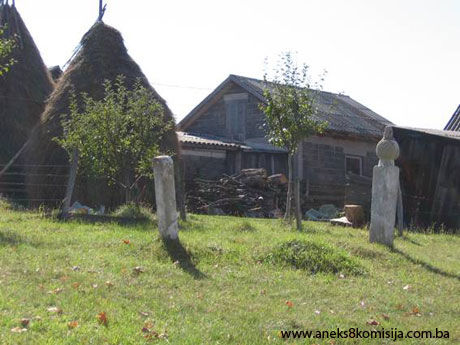
Nišan tombstones at Gromile
Three old nišan tombstones stand on a plot designated as c.p. no. 256/7, about 60 m to the north of the necropolis. One of the tombstones is decorated with motifs of a sword and the sun.
Condition of the nišan tombstones:
Nišan no. 1.
Man's nišan with pleated turban, without epitaph, rectangular in section, 15 x 13 cm with a height of 166 cm. A sword is carved on the south-east side of the tombstone, and a number of concentric circles carved on the front, south-west side, symbolizing the sun.
Nišan no. 2.
Footstone, 18 x 15 cm in section, with a height of 100 cm, undecorated.
Nišan no. 3.
Rectangular in section, 24 x 17 cm, with a height of 80 cm, without epitaph; terminating in a cylindrical form topped by a protuberance.
Necropolis with stećci at Višgreblje or Jabuka
Here Š. Bešlagić recorded 21 stećak tombstones (five gabled and sixteen chest-shaped), none decorated, and all lying west-east (Š. Bešlagić, 1967, p. 27). However, during a survey of the necropolis, thirty stećci were found (25 chest-shaped and five gabled), lying north-south and west-east. The tombstones are of crude workmanship, badly damaged, and partly buried. The necropolis with stećci is on a plot designated as c.p. nos. 1989, 1988 and 1986, and the necropolis with nišans is on a plot designated as c.p. nod. 1991 and 1992, where the local Muslim burial ground still in use for the residents of the village of Budoželje is located.
In addition to their more recent nišan tombstones, the burial ground contains about twenty old ones, of simple design, noticeably suffering from the ravages of time, lacking epitaphs, and most partly buried or lying on the ground. One nišan bears the date 1132 (1719/20), and the other an epitaph dating from 1884/85(5). The lack of space for more recent burials has resulted in a tendency to extend new burials in the direction of the stećci, thereby placing them at risk.
Condition of the stećci:
Stećak no.1 – chest, crudely worked, undecorated, almost completely buried, lying west-east.
- the stećak measures 130x75 cm.
Stećak no. 2 – chest, almost completely buried and covered with moss, overgrown with scrub and grass, lying west-east.
- the stećak measures 150x80 cm.
Stećak no. 3 – chest, crudely worked, almost completely buried, covered with moss and overgrown with grass, lying west-east.
- the stećak measures 109x30 cm.
Stećak no. 4 – gabled, of good workmanship, but damaged and partly buried, covered with moss and overgrown with grass, lying north-south.
- the stećak measures 137x47x23 cm.
Stećak no. 5 – chest, of good workmanship, but damaged and partly buried, covered with moss and overgrown with grass, lying north-south.
- the stećak measures 184x79x31 cm.
Stećak no. 6 – gabled, of good workmanship, damaged, partly buried and overgrown with grass, lying north-south.
- the stećak measures 154x60x30 cm.
Stećak no. 7 – chest, crudely worked, partly buried, covered with moss and overgrown with grass, lying west-east.
- the stećak measures 150x90x27 cm.
Stećak no. 8 – gabled, of good workmanship, damaged and covered with moss, lying north-south.
- the stećak measures 170x81 (width at base 67), x 65 cm.
Stećak no. 9 – chest crudely worked, partly damaged, overgrown with grass and low-growing weeds, lying west-east.
- the stećak measures 163x63x35 cm.
Stećak no. 10 – chest, crudely worked, almost completely buried, covered with moss and overgrown with grass, lying west-east.
- the stećak measures 194x67 cm.
Stećak. no. 11 - chest, crudely worked, almost completely buried, overgrown with grass and low-growing weeds, lying west-east.
- the stećak measures 140x56 cm.
Stećak. no. 12 - gabled, overturned onto its south side, partly buried and covered with moss and overgrown with low-growing weeds, lying west-east.
- the stećak measures 110x30x45 cm.
Stećak no. 13 – chest, crudely worked, broken lengthwise, covered with moss and overgrown with low-growing weeds, lying west-east.
- the stećak measures 150x80x26 cm.
Stećak no.14 – chest, crudely worked, partly buried and overgrown with grass and low-growing weeds, lying north-south.
- the stećak measures 174x80x20 cm.
Stećak no. 15 – gabled, of good workmanship, partly buried and overgrown with grass and low-growing weeds, lying north-south.
- the stećak measures 143x54x45 cm.
Stećak no. 16 – chest, crudely worked, partly buried and covered with moss, overgrown with low-growing weeds, lying north-south.
- the stećak measures 150x60x20 cm.
Stećak no. 17 – chest, almost completely buried, overgrown with low-growing weeds, lying north-south.
- the stećak measures 156x67x20 cm.
Stećak no. 18 – chest, almost completely buried, overgrown with grass and low-growing weeds, lying north-south.
- the stećak measures 150x70x10 cm.
Stećak no. 19 – chest, almost completely buried, overgrown with grass and low-growing weeds, lying north-south.
- the stećak measures 150x90 cm.
Stećak no. 20 – chest, almost completely buried, overgrown with grass and low-growing weeds, lying north-south.
- the stećak measures 150x75 cm.
Stećak no. 21 – chest, crudely worked, partly buried and covered with moss, overgrown with grass, lying north-south.
- the stećak measures 180x84x30 cm.
Stećak no. 22 –chest, crudely worked, partly buried, overgrown with grass and low-growing weeds, lying west-east.
- the stećak measures 160x86x20 cm.
Stećak no. 23 – chest, almost completely buried, overgrown with grass and low-growing weeds, lying north-south.
- the stećak measures 160x70 cm.
Stećak no. 24 – gabled, tilted to the east side, covered with moss and overgrown with weeds, lying north-south.
- the stećak measures 185x72x60 cm,
- the plinth measures 225 cm long x 20 cm high.
Stećak no. 25 – gabled, tilted to the east side, covered with moss and overgrown with weeds, lying north-south.
- the stećak measures 168x72x80 cm,
- the plinth measures 210 cm long x 20 cm high.
Stećak no. 26 – chest, partly buried and covered with moss, overgrown with low-growing weeds, lying north-south.
- the stećak measures 160x80x28 cm.
Stećak no. 27 – chest, almost completely buried, overgrown with grass, lying west-east.
- the stećak measures 163x27 cm.
Stećak no. 28 – chest, almost completely buried, overgrown with grass, lying north-south.
- the stećak measures 157x75 cm.
Stećak no. 29 – chest, almost completely buried, overgrown with grass, with only its outlines visible, lying west-east.
Stećak no. 30 – chest, almost completely buried, overgrown with grass, lying north-south.
- the stećak measures 160x70 cm.
Nišan tombstones in the village burial ground close to Višgreblje or Jabuka
Condition of the tombstones:
Nišan no. 1
Man's nišan with turban, the mudževeze (top of the nišan) broken off, 18 x 17 cm in section and 60 cm in height, and bearing a zigzag band and the date 1132 (1719/20).
Nišan no. 2
A more recent nišan with a fez, rectangular in section, 11 x 8 cm, and 70 cm in height, bearing an epitaph in Arabic:
مقام مرحوم و مغفور له محارم بن سلمان شحيج روحنه الفاتحة سنة 1302
The place of the late Muharem, rest his soul, son of Selman Šehić. [Recite] Fatiha for his soul. 1302 (1884/85).
Necropolis with stećci at Solila or Trzan(6)
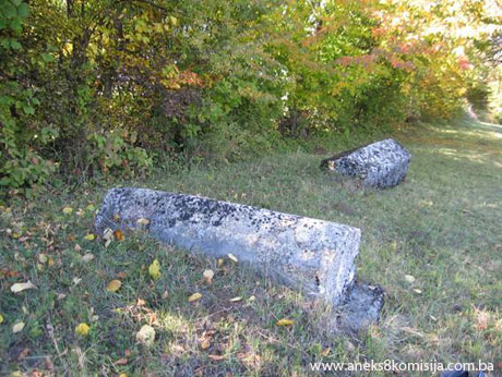
This necropolis with stećci is about 500 m as the crow flies to the east of Višgreblje or Jabuka, on a plot designated as c.p. nos. 957 and 2406. There are twelve stećci on the site (eight chest-shaped and four gabled). Here Š. Bešlagić recorded 13 stećci (nine chest-shaped and four gabled) (Š. Bešlagić,1967, p. 27). The tombstones lie west-east and north-south. Only one – a gabled tombstone – is decorated.
Condition of the stećci:
Stećak no.1 – gabled, covered with moss and overgrown with low-growing weeds, undecorated, lying west-east.
- the stećak measures 140x50x48 cm.
Stećak no. 2 – gabled, covered with moss and overgrown with low-growing weeds, undecorated, lying west-east.
- the stećak measures 140x50x42 cm.
Stećak no. 3 – chest, crudely worked, partly buried and overgrown with grass and low-growing weeds, lying west-east.
- the stećak measures 145x50x10 cm.
Stećak no. 4 – chest, partly buried and overgrown with brambles and low-growing weeds, lying north-south.
- the stećak measures 130x40x17 cm.
Stećak no. 5 – chest, partly buried and overgrown with brambles and low-growing weeds, lying north-south.
- the stećak measures 140x56x20 cm.
Stećak no. 6 – chest, partly buried and covered with moss, overgrown with grass and low-growing weeds, lying west-east.
- the stećak measures 180x80x47 cm.
Stećak no. 7 – gabled, partly buried, covered with moss, overgrown with grass and low-growing weeds, lying west-east.
- the stećak measures 147x72x43 cm.
Stećak no. 8 – chest, crudely worked, damaged, partly buried and covered with moss, overgrown with low-growing weeds, lying west-east.
- the stećak measures 175x80x30 cm.
Stećak no. 9 – chest, of good workmanship, damaged, partly buried and covered with moss, overgrown with low-growing weeds, lying west-east.
- the stećak measures 180x80x70 cm.
Stećak no. 10 – chest, damaged, partly buried and covered with moss, overgrown with low-growing weeds, lying north-south.
- the stećak measures 150x60x27 cm.
Stećak. no. 11 – chest, damaged, partly buried and covered with moss, overgrown with low-growing weeds, lying north-south.
- the stećak measures 160x88x40 cm.
Stećak. no. 12 – gabled with plinth and decoration, covered with moss and overgrown with low-growing weeds, lying north-south.
- the stećak measures 174x80x57 cm,
- the plinth measures 210 cm long x 20 cm high.
The tombstone is decorated with an arm with a sword on the west side. Š. Bešlagić recorded another motif on the south end - “two crescent moons with their convex sides touching” (Š. Bešlagić, 1976, p. 27)(7). If the road were to be widened or a landslide to occur this stećak could be displaced from its original position.
Necropolis with stećci at Vrh
This site, with two gabled tombstones lying south-west/north-east and north-west/south-east, is not recorded in the works consulted. The stećci are on a plot designated as c.p. no. 981.
Condition of the stećci:
Stećak no.1 – gabled with plinth, undecorated, covered with grass, lying south-west/north-east.
- the stećak measures 172x55x48 cm,
- the plinth measures 205x83x15 cm.
Stećak no. 2 – gabled, partly buried and covered with moss, lying north-west/south-east.
- the stećak measures 196x75x57 cm.
3. Legal status to date
The Regional Plan for BiH to 2000 lists 17 sites of necropolises with stećci (303 tombstones) in Vareš Municipality as Category III monuments, without precise identification (various authors, 1980, p. 50).
In a letter from the Institute for the Protection of Monuments of the Federal Ministry of Culture and Sport dated 23 September 2008, the necropolises listed for the village of Budoželje are “Necropolis of stećci Glavica” and “Necropolis of stećci Budoželj 1 and 2, Budoželj, Vareš.” They are not on the Register of cultural monuments of the Socialist Republic of Bosnia and Herzegovina.
4. Research and conservation and restoration works
Research works, consisting of recording and visiting the sites in Vareš Municipality and noting their condition, were conducted by Šefik Bešlagić from 1964 to 1966, and published in his Stećci centralne Bosne in 1967.
No conservation or restoration works have been carried out.
5. Current condition of the property
The findings of an on site inspection conducted on 8 October 2008 are as follows:
- there are 36 stećci at Glavica or Hrid (34 chest-shaped and two gabled),
- the stećci are crudely worked and in a poor state of preservation, and are lying north-west/south east and north-south,
- one stećak (gabled no. 10) is decorated with the figures of a man and a horse, and a horse and crescent moon,
- two graves were found in front of stećci nos. 34, 35 and 16, where there had been stećci,
- stećci nos. 10 and 36 are gabled, the remainder are chest-shaped,
- stećci bos. 3, 4 and 5 are separated by a fence from the necropolis and now stand on private property,
- some 60 km to the north of the necropolis are three old nišan tombstones one of which is decorated with a sword and sun motif,
- 30 stećci (23 chest-shaped and seven gabled) were found at Višgreblje or Jabuka, about 700 m as the crow flies to the east of Glavica,
- the village burial ground contains not only new nišan tombstones but also about twenty old ones, of simple design, noticeably suffering from the ravages of time, without epitaphs, and most partly buried or lying on the ground,
- one nišan bears the date 1132 (1719/20) and another an epitaph dating from 1884/85,
- twelve stećci (eight chest-shaped and four gabled) were found at Solila or Trzan (about 500 m as the crow flies to the east of Višgreblje or Jabuka),
- one stećak (no. 12) is decorated with an arm and sword motif,
- there are two gabled stećci at Vrh, about 300 m as the crow flies to the east of Solila or Trzan,
- plant organisms, mainly lichens and moss, are present on most of the stećci and are breaking up the structure of the stone,
- with renewed plant growth in spring the necropolises become overgrown with grass, brambles and weeds,
- the stećci are chipped, damaged, overturned, or partly or almost completely buried,
- the stećci are at risk of rapid deterioration as a result of neglect.
6. Specific risks
- attempts to protect the stećci by local residents of Budoželje,
- tendency to extend burials towards the stećci, thereby putting them at risk,
- risk to stećak no. 12 at Solila or Trzan in the event of landslide or road widening,
- deterioration of the necropolis as a result of long-term neglect,
- adverse weather conditions,
- self-sown vegetation.
III – CONCLUSION
Applying the Criteria for the adoption of a decision on proclaiming an item of property a national monument (Official Gazette of BiH nos. 33/02 and 15/03), the Commission has enacted the Decision cited above.
The Decision was based on the following criteria:
A. Time frame
B. Historical value
C. Artistic and aesthetic value
C.iii. proportions
C.v. value of details
D. Clarity
D. i. material evidence of a lesser known historical era
E. Symbolic value
E.i. ontological value
E.v. significance for the identity of a group of people
G. Authenticity
G.i. form and design
The following documents form an integral part of this Decision:
- Copy of cadastral plan,
- Copy of land register entry,
- Photodocumentation, photographs taken on site.
Bibliography
During the procedure to designate the property as a national monument of Bosnia and Herzegovina the following works were consulted:
1924. Glušac, Vaso, Srednjovekovna "bosanska crkva", in: Prilozi za književnost, jezik, istoriju i folklor, IV (The Mediaeval “Bosnian Church,” in Contributions to Literature, Language, History and Folklore, IV, Belgrade, 1924.
1943. Kreševljaković, Hamdija, “Vareš kao glavno središte gvozdenog obrta u Bosni i Hercegovini” (Vareš as the Main Centre of the Iron-working Trade in Bosnia and Herzegovina), Jnl of the Croatian National Museums in Sarajevo, yr. LIV. – 1942, Sarajevo, 1943.
1955. Vego, Marko, “Nalaz dubrovačkih dinara u Varešu” (A Find of Dubrovnik Dinars in Vareš), Jnl of the National Museum, Arch. n.s. vol. X, Sarajevo, 1955.
1957. Vego, Marko, Naselja bosanske srednjovjekovne države (Settlements of the Mediaeval Bosnian State), Sarajevo, 1957.
1963. Benac, Alojz, Stećci, Prosveta, Belgrade, 1963.
1967. Bešlagić, Šefik, Stećci centralne Bosne, (Stećci of Central Bosnia), Sarajevo, 1967.
1971. Anđelić, Pavao, “Stara bosanska župa Vidogošća ili Vogošća” (the Old Bosnian County of Vidogošća or Vogošća), Jnl of the National Museum, Arch. n.s. vol. XXVI, Sarajevo, 1971.
1971. Bešlagić, Šefik, Stećci, kataloško-topografski pregled (Stećci, a Catalogue and Topographical Overview), Sarajevo, 1971.
1978. Anđelić, Pavao, “Srednjovjekovna župa Kamenica ili Krivaja” (the Mediaeval County of Kamenica or Krivaja), Jnl of the National Museum, Arch. n.s. vol.. XXXII/1977, Sarajevo, 1978.
1980. Various authors, Institute for architecture, town planning and regional planning of the Faculty of Architecture in Sarajevo, Regional Plan for Bosnia and Herzegovina; Stage B - valorization of natural, cultural and historical monuments, Sarajevo, 1980, p. 51.
1982. Anđelić, Pavao, “Problem naselja i užeg teritorija pod imenom Bosna” (The Problem of Settlement and the Inner Territory Known as Bosnia), in Studije o teritorijalnopolitičkoj organizaciji srednjovjekovne Bosne (Studies on the Territorial and Political Organization of Mediaeval Bosnia), Sarajevo, 1982.
1982. Anđelić, Pavao, “Srednjovjekovna župa Trstivnica” (The Mediaeval County of Trstivnica), in Studije o teritorijalnopolitičkoj organizaciji srednjovjekovne Bosne (Studies on the Territorial and Political Organization of Mediaeval Bosnia), Sarajevo, 1982.
1982. Bešlagić, Šefik, Stećci. Kultura i umjetnost (Stećak tombstones – culture and art), Veselin Masleša, Sarajevo, 1982.
1984. Anđelić, Pavao, “Srednji vijek – doba stare bosanske države” (The Middle Ages – the Age of the Old Bosnian State) in Visoko i okolina kroz historiju I, (predhistorija, antika i srednji vijek) (Visoko and Environs Through History 1 [Prehistory, Antiquity and the Middle Ages]), Visoko, 1984.
1984. Bojanovski, Ivo, “Razdoblje rimske uprave” (The Roman Period) in Visoko i okolina kroz historiju I, (predhistorija, antika i srednji vijek) (Visoko and Environs Through History 1 [Prehistory, Antiquity and the Middle Ages]),Visoko, 1984.
1990. Südland, L. V. (Ivo Pilar), Južnoslavensko pitanje. Prikaz cjelokupnog pitanja, Varaždin (The Yugoslav Question. Full account of the issue, Varaždin). Title of original: L. v. SÜDLAND, Die Südslawische Frage und der Weltkrieg. Übersichtliche Darstellung des Gesamt-Problems, Wien 1990.
2009. Lovrenović, Dubravko, Stećci, Sarajevo, 2009.
http://www.earth.com/
(1) Coordinates taken on 21 November 2008 from http://www.earth.com/
(2) Merchants from Dubrovnik were permanent guests in Droškovac and Duboštica in mediaeval times, as evidenced by the find of Dubrovnik dinars in Vareš in the hamlet of Droškovac. About 400 coins were found, of which 143 were saved and are housed in the National Museum, the Provincial Museum in Visoko and the City Museum in Sarajevo (M.Vego, Jnl Nat.Mus., Arch. n.s. vol. X, Sarajevo 1955, pp. 211-215).
(3) For more on stećci, see decision of the Commission designating the historic site of the Mramorje necropolis with stećci and old nišan tombstones in Lavšići, Municipality Olovo, as a national monument of Bosnia and Herzegovina, no: 02-02-228/07-95, November 2008, and the Commission's web site: www.aneks8komisija.com.ba
(4) On 14 April 2004 Jasna Burnazović inspected the site of Glavica (Hrid) in Budoželje and recorded 37 stećci, as had Šefik Bešlagić before her (Š. Bešlagić, Stećci, kataloško-topografski pregled, Sarajevo, 1971, p. 153; Stećci centralne Bosne, Sarajevo, 1967, pp. 26 and 27). Stećak no. 17 was recorded as two (nos. 17 and 18), probably because it had been put back together with mortar. I am of the view that this is a single stećak and its plinth, and that the residents of Budoželje, anxious to protect it, must have mortared the two parts together.
(5) Translator’s note: this appears to contradict the assertion that the tombstones have no epitaphs. Since the word natpis used in the original means both epitaph and inscription, there may be no contradiction, but further information would be needed to clear this up.
(6) The toponym Trizna denotes a dancing ground. Ethnological studies of the South Slavs have shown that this is a deeply-rooted, pre-Christian custom associated with the posthumous ritual of holding a funeral ceremony, recorded in the Kiev Chronicle (11th-12th century) by the name trizna, as being performed by old Russians. There is no detailed description of the old Russian trizna, but in Church Slavonic the word trizna in its various forms denotes a battle, and in modern Ukrainian it means a funeral banquet.
The word first features among the South Slavs in various forms – trzna-trzan – in the early 16th century, suggesting that the word trzna or trzan was already in their vocabulary when they settled in the Balkans. Nowadays the word trzan or trzna, like the toponym Trzan in central Bosnia and to some extent beyond, denotes a small grassy area of level ground, a greensward or village green, in the middle or at one end of a village, used as a place for meeting and amusement, but also close to a burial ground, suggesting that the word preserves the memory of the old Slav trizna. It makes sense, therefore, to assume that the round-dances depicted on mediaeval stećci formed part of a funerary ritual, accompanied in some cases by tournaments and jousting, since in some round-dance scenes the men are shown wearing warriors' garb. The fact that round-dance scenes are found on stećci over the sizeable area in Bosnia and Herzegovina where trzan is known is also suggestive. There are also vestiges, or the memory, of the trizan in surviving folk customs, such as that of eating and drinking one's fill after a funeral, which then ends in merriment, while in Bosnia and some neighbouring regions funerals sometimes end with a dance, known as the “ dance of grief” in Kupres and the “mourning dance” in Herzegovina, which is danced widdershins, counterclockwise instead of clockwise. In the old days most people in Herzegovina held a wake after the funeral, when people ate, drank and then danced at the grave. A stećak in Brotnica near Dubrovnik depictgs a woman holding a basket on her head, probably containing food for the funeral guests. Until recently, folk revels were held at some places known as igrište [also denoting a dancing-ground] or trzan, as for example in the village of Večići near Kotor-Varoš, where there is a place called Trzan with a mediaeval necropolis with eighty stećci and a Muslim burial ground next to it. Here picnics were held and the Muslim religious rituals of mevlud and dova [Ar. du'a, individual prayers, spontaneous or composed]. Further evidence of how widespread the custom of feasting at funerals or after burial is to be found in the early Reformation propaganda accusing the Catholic priesthood of gluttony over the dead. In Poland this often resulted in brawls between funeral guests, but did not bring them to abandon the old customs, which no doubt prompted these later condemnations. Nor is it lacking in significance – if the matter is seen in the light of those times – that in the Mediterranean world eating and funerals were closely associated in both practice and polemic. Christians at first rejected and then adopted the Roman custom of a funeral banquet. (D. Lovrenović, 2009, pp. 72 and 73).
(7) During the examination of the stećak this decoration was not found, because the stećak had earth piled up against it, and was partly buried and overgrown with brambles and weeds on the north, south and east sides.
|