Status of monument -> National monument
Published
in the “Official Gazette of BiH”, no. 84/09.
Pursuant
to Article V para. 4 Annex 8 of the General Framework Agreement for Peace in Bosnia and Herzegovina
and Article 39 para. 1 of the Rules of Procedure of the Commission to Preserve
National Monuments, at a session held from 9 to 15 September 2008 the
Commission adopted a
D E C I S
I O N
I
The
architectural ensemble of the mosque in Umoljani, Municipality Trnovo, is
hereby designated as a National
Monument of Bosnia and Herzegovina
(hereinafter: the National Monument).
The
National Monument consists of the mosque and harem with burial ground.
The
National Monument is located on a site designated as cadastral plot no. 1311,
title deed no. 263, cadastral municipality Umoljani, Municipality Trnovo, Federation
of Bosnia and Herzegovina, Bosnia and Herzegovina.
The
provisions relating to protection measures set forth by the Law on the
Implementation of the Decisions of the Commission to Preserve National
Monuments, established pursuant to Annex 8 of the General Framework Agreement
for Peace in Bosnia and Herzegovina (Official Gazette of the Federation of BiH
nos. 2/02, 27/02, 6/04 and 51/07) shall apply to the National Monument.
II
The
Government of the Federation of Bosnia and Herzegovina (hereinafter: the
Government of the Federation) shall be responsible for providing the legal,
scientific, technical, administrative and financial measures necessary for the
protection, conservation, presentation and restoration of the National
Monument.
The
Government of the Federation shall be responsible for providing the funds for
drawing up and implementing the technical documentation required for the
restoration of the National Monument.
The
Commission to Preserve National Monuments (hereinafter: the Commission) shall
determine the technical requirements and secure the funds for preparing and
erecting signboards with basic details of the monument and the Decision to
proclaim the property a National Monument.
III
To ensure
the on-going protection of the National Monument, the following protection
measures are hereby stipulated:
Protection
level I applies to the site defined in Clause 1 para. 3 of this Decision.
On this site, all works are prohibited other than conservation and restoration
works, with the approval of the Federal Ministry responsible for regional
planning and under the expert supervision of the heritage protection authority
of the Federation of Bosnia
and Herzegovina.
Protection
level II applies to a buffer zone consisting of cadastral plots no.
1308, 1309, 1310, 1312, 1313, 1314, 1315, 1316, 1387, 1388, 1389, 1390, 1391,
1392, 1393, 1394, 1398, 1399, 1400, 1906, 1907, 1908, 1910, 1911, 1912, 1913
and 4718, title deed no. 263, c.m. Umoljani, Municipality Trnovo, Federation of
Bosnia and Herzegovina, Bosnia and Herzegovina. The following protection
measures shall apply within this zone:
-
the construction of
industrial facilities and of properties that could be detrimental to the
National Monument in appearance and size is prohibited;
-
buildings may be erected
on the basis of the area planning and technical conditions prescribed by the
heritage protection authority.
IV
All
executive and area development planning acts not in accordance with the
provisions of this Decision are hereby revoked.
V
Everyone,
and in particular the competent authorities of the Federation of Bosnia and
Herzegovina, the Canton, and urban and municipal authorities, shall refrain
from any action that might damage the National Monument or jeopardize the
preservation thereof.
VI
The
Government of the Federation, the Federal Ministry responsible for regional
planning, the Federation heritage protection authority, and the Municipal
Authorities in charge of urban planning and land registry affairs, shall be
notified of this Decision in order to carry out the measures stipulated in
Articles II to V of this Decision, and the Authorized Municipal Court shall be
notified for the purposes of registration in the Land Register.
VII
The
elucidation and accompanying documentation form an integral part of this
Decision, which may be viewed by interested parties on the premises or by
accessing the website of the Commission (http://www.aneks8komisija.com.ba)
VIII
Pursuant
to Art. V para 4 Annex 8 of the General Framework Agreement for Peace in Bosnia and Herzegovina,
decisions of the Commission are final.
IX
This
Decision shall enter into force on the day following its publication in the
Official Gazette of BiH.
This
Decision has been adopted by the following members of the Commission: Zeynep
Ahunbay, Martin Cherry, Amra Hadžimuhamedović, Dubravko Lovrenović and Ljiljana
Ševo.
No: 06.1-02-110/07-9
10 September 2008
Sarajevo
Chair of
the Commission
Ljiljana
Ševo
E l u c i
d a t i o n
I – INTRODUCTION
Pursuant
to Article 2, paragraph 1 of the Law on the Implementation of the Decisions of
the Commission to Preserve National Monuments, established pursuant to Annex 8
of the General Framework Agreement for Peace in Bosnia and Herzegovina, a
“National Monument” is an item of public property proclaimed by the Commission
to Preserve National Monuments to be a National Monument pursuant to Articles V
and VI of Annex 8 of the General Framework Agreement for Peace in Bosnia and
Herzegovina and property entered on the Provisional List of National Monuments
of Bosnia and Herzegovina (Official Gazette of BiH no. 33/02) until the
Commission reaches a final decision on its status, as to which there is no time
limit and regardless of whether a petition for the property in question has
been submitted or not.
On 14
June 2007, Bandić Dervo of ......... submitted a petition/proposal to
designate the mosque in Umoljani as a national monument of Bosnia
and Herzegovina.
Pursuant
to the provisions of the law, the Commission proceeded to carry out the
procedure for reaching a final decision to designate the Property as a National
Monument, pursuant to Article V para. 4 of Annex 8 and Article 35 of the Rules
of Procedure of the Commission to Preserve National Monuments.
II – PROCEDURE PRIOR TO DECISION
In the
procedure preceding the adoption of a final decision to proclaim the property a
national monument, the following documentation was inspected:
-
Documentation on the
location and the current owner and user of the property (copy of cadastral
plan).
-
Details of the current
condition and use of the property, including a description and photographs,
data of war damage, data on restoration or other works on the property, etc.
-
Historical, architectural
and other documentary material on the property, as set out in the bibliography
forming part of this Decision.
The
findings based on the review of the above documentation and the condition of
the site are as follows:
1. Details of the property
Location
The
plateau bounded by Bjelašnica to the north, Treskavica to the east, Visočica to
the south and Mt Obalj to the west is known as the Bjelašnica plateau. Here, in
this south-eastern area of Bjelašnica, also known as lower Bjelašnica, are
permanent settlements at altitudes of between 1150 and 1472 m above sea level. The
villages of Umoljani, Kramari, Lukavac, Brda, Milešići, Šabići and Rakitnica
lie along the right bank in the upper reaches of the river Rakitnica, which
separates Mts. Bjelašnica and Visočica, while the larger villages of Bobovica
and Tušila are located on the hills by the left bank. Down-river to the west of
this group of villages are the villages of Lukomir, Ćuhovići and Blaca. The
entire region was linked with the Sarajevo
plain to the north-east, via Štirni Do, with Konjic to the west, via Jagodin Do
and Radobolja.
In the
past decade, the villages on the Bjelašnica plateau have been linked by road
with Sarajevo,
via Hadžići. An asphalt road 49 km in length connects the village
of Umoljani with Sarajevo via Krupac, Babin Do and Šabići,
while another asphalt road 57 km in length runs between Umoljani and Hadžići
via Igman, Babin Do and Šabići.
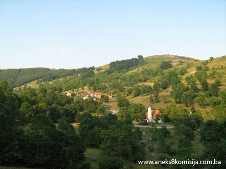
The
architectural ensemble of the mosque is at an altitude of 1350 m above sea
level, on a site designated as cadastral plot no. 1311, cadastral municipality
Umoljani, Municipality Trnovo, Federation of Bosnia and Herzegovina, Bosnia and Herzegovina.
Historical information
The
Bjelašnica plateau has not been studied in any great detail, whether
archaeologically or historically, and there are very few reference works
dealing with the area. It was already settled in prehistoric times: one such
site is on high ground above the Umoljani katun (summer pasture)
settlement of Gradina.(1)
In late
mediaeval times the area from the river Rakitnica to the east to the little
river Trešanica to the west belonged to the administrative district (knežija)
of Črešnjevo(2) in the
Neretva župa (county), which was divided by the river Neretva in the
early 15th century into the Bosnian half and the Herzegovina half, on the left
bank, which belonged to Hum land, later known as Herzegovina, and hence to
local overlords from the Kosača family.
The
south-eastern area of Bjelašnica, which was on the eastern border of the
Črešnjevo knežija, was seemingly inhabited by Vlachs (Vlach katunars or
herdsmen).
Popović,
Đ, Cvetko, writes of the Bjelašnica katuns:
“Since
ancient times, the extensive, succulent pastures of Bjelašnica have attracted
herdsmen from Herzegovina,
where animal feed is scarce in summer. As a result, as well as the few
permanent settlements on Bjelašnica, there are also several seasonal
settlements or mahalas, as the herdsmen call them. Each of these mahalas had
its own name. On the Herzegovina or east and south side of Bjelašnica, near the
village of Umoljani, were the mahalas of Razošlje, Hrupe, Kekuše, and further
westward Ajvazi, Lovnica, Raški Do, Jasen and Zelene Njive, while on the
Bosnian, northern side of Bjelašnica were the mahalas of Karamustafini Čairi,
Mrtvanje, Krošnje, Stanine, Hranisava, Opančar and Gola Obrva. Life in these
mahalas was even more primitive than in the permanent settlements on
Bjelašnica, which are very much mountain settlements in which the main
occupation is livestock rearing. Most of the villages had grown over time from
mahalas, and their present-day inhabitants are of Herzegovina origins. The name of
the village of Umoljani comes from “Humljani.”(3)
The
toponomastic material of Bjelašnica – Vlahinja (two places on Bjelašnica), Vlaščeta
and Katun in Tušili, Donji Kramari and Gornji Kramari(4), and Vlaško greblje in Lukomir,
also corroborates this assertion.
The
toponomastics of the upper reaches of the Rakitnica, where Šabići is also
located, suggest that the villages were organized into communes, consisting of
small groups of clan-based villages. The political function of the commune was
exercised in a fort or castle. The name Grad (fort or town) of a hill above
Lukavac indicates a site probably built by a village commune. In late mediaeval
times there was a clear preference for each territorial political entity to
have its own fort, usually simply known as Grad without any other means of
identification. The toponym Varda is to be found in Umoljani, Tušili and
Šabići, suggesting the organized military and police force of such entities.
The commune would also have a central place of worship. It is common for the
later centres of a džemat (Ar. jama’ah, congregation) with a
Friday mosque to be on the site of a mediaeval communal place of worship. It
would seem that Umoljani was and remained the religious centre of this village
commune, as evidenced by the site known as Crkvina (indicating the presence of
a church)(5), between
Umoljani and Šabići, and the mosque in Umoljani.(6)
The
summary census of the Bosnia
sanjak for 1468/69(7) refers
to part of the village
of Umoljani, with 31
households, as “part of the Neretva military(8) reserve, in the hands of the said Hajji Mehmedi.
The
1488/89 census refers to the village
of Umoljani, and among
the list of inhabitants are Muslim first-generation names, such as Ahmed son of
Milobrad, Mehmed son of Marko, Yusuf son of Milobrad and so on. Umoljani had
twenty houses and a total income of 1,046 akča(9). This suggests that Islam reached the people of Lukomir at a very
early date and that the villagers began to embrace Islam very soon after Bosnia fell to
the Ottomans.
The
detailed census of the Klis sanjak for 1550(10) lists the village
of Umoljani, in the
Neretva nahija (minor administrative district), as a timar (feudal holding) of
Nesuh, son of Ejnehan, Mahmud, son of Ejnehan, and Davud, son of Ejnehan. The
village had the following: “households: Muslim 76, bachelor 21, hereditaments
6, resmi čift 2.056; households: Christian 9, ispendža(11) 225. The revenue was 6,427
akča.” There is also reference by name to vojnuks of the village of Umoljani
and their income of 959 akča, and to akindžije(13) of the village of Umoljani: households: Muslim 6, bachelor 3,
hereditament 1, resmi čift 190; households: Christian 6, ispendža 150 akča, and
their income of 1,004 akča. The owners of all the čifluks with their income are
listed by name). The total revenue was 9,506 akča, of which “the share of the
said Nesuh: 3,000; the share of the said Mahmud: 3,000; the share of the said
Davud: 2,800. The share of another: 706, in the timar of Sulejman, garrison
commander of the Gradiška fort.”
The 1574
census refers to the village
of Umoljani, with all the
holders of estates Muslims (69 in all) whose forebears were non-Muslims. The
census refers to 42 hereditaments(14) and 17 čifluks(15) with
total revenue of 13,500 akča.(16)
There is
no written record of the first construction of the mosque in Umoljani, and nor
is there any surviving vakufnama or other document that might help to date it
reliably. There are, however, certain facts and observations that implicitly
suggest a possible time frame:
-
the number of residents of
Umoljani who embraced Islam in the 16th century (details from the censuses)
-
the fact that in late
mediaeval times, the Ottoman period, and to this day, Umoljani has been the
religious centre of the area
-
the present-day location
of the mosque, to the south of modern Umoljani, which is unusual in the light
of the custom of building mosques where they could most easily be reached by
all the congregation. To make access to free pastureland easier, as time elapse
the village was relocated some 300 metres to the north. The assumption that the
village was once further to the south, with the mosque in the middle of the
village, is suggested by the toponym Donje selo (lower village – the name of
the area to the south of the village where there is not a single building now
standing, though about twenty years ago there were still a few cowsheds there,
the remains of which can be seen in the immediate vicinity of the mosque)
-
the people of Umoljani
have an oral tradition, passed down from generation to generation, that the
timber used to build the mosque was cut in the forest at a place called Potoci,
where there has been not a single tree large enough to provide timber for
building purposes for the past two hundred years, implying that the mosque
could have been built prior to the 18th century
-
the old nišan tombstones
(without epitaphs) in the harem of the mosque.
All this
suggests that there was a mosque there more than 200 years ago, and that the
present-day mosque was probably built in the early 20th century.
It is the
tradition in Umoljani to hold a mevlud (Ar. maulid, originally a
commemoration of the Prophet Muhammad’s birthday) in the summer (July and
August)(17), usually
attended by several thousand people. “In the history of this part of the world,
no lower-ranking religious official, let alone the supreme leader of the
Muslims(18), has
ever come here a third time. It is hard for him, as supreme leader of the Muslims,
to cover more than 15 km on foot along a very bad road, over the wild [terrain]
of Mt. Bjelašnica,
to visit the village
of Umoljani. . . The
people of this area were thrilled by the arrival of their religious leader. His
surprise appearance in Umoljani meant great celebrations by all the residents. He
made a very moving speech to the more than 3,000 Muslims at the Mevludi-šerif.”
(19)
The
Muslims of the villages of Bjelašnica helped the mosque; “one who stands out
among them is the late Tatarović hajji Ahmed of Umoljani, who before his death
donated a ćilim (kilim) to the mosque, worth more than 70,000 old dinars, and
endowed a vakuf (pious endowment) worth 20,000 dinars and made donations of
about 16,000 old dinars. Others who stand out are the late Čomor Halil of
Lukomir, who bequeathed to the mosque a ćilim worth about 60,000 old dinars,
and Muharem Tatić, who gave land for the enlargement of the harem and mosque to
the value of about 80,000 old dinars. A resident of Lukavac, not far from
Umoljani, brought water from a spring to the mosque, a distance of about 50 m,
at his own expense. Vatrić Zejnil gave about 35,000 old dinars for the Islamic
community . . .” (20)
According
to a resident of the village of Umoljani, Bandić Omer (b. 1930), the imams of
the mosque in Umoljani were Džihan Omer (1890-1900), Bandić Hamid (1910-1920),
Bandić Meho (during Royal Yugoslavia), hafiz Medić Rasim of Prijedor, Aljević
Vejsil (who held the post of imam for 30 years), Bandić Duran, Drkić Alija
(1992-1995) and, since 1999, the imam is Ahmed Bandić.
In 1993,
thirteen villages on Bjelašnica were set on fire, and the only property that
was not, in August 1993, was the mosque in Umoljani: all the houses in the
village were burned to the ground. There are various stories and legends to
explain the survival of the mosque.
On 21
August 2008, during an on-site inspection of the condition of the property,
compiling photodocumentation and conducting a technical survey of the building,
an inscription was found on one of the beams forming the structure of the
mahfil (in the vestibule of the mosque, before the second entrance door to the
main prayer hall), carved into the wood in Cyrillic, and reading: ГАТАЧКИ
ЧЕТНИЦИ.
2. Description of the property
The
architectural ensemble consists of the mosque and burial ground.
The
mosque is rectangular in plan, with sides measuring approx. 8.07(21) (8.20(22)) x 14.10 (15.55)(23)m on the outside, and in layout
consisting of an open entrance portico of approx. 1.45 x8.07 m, a vestibule of
approx. 3.42 x 4.77 m with a staircase leading to the mahfil, an abdesthana of
approx. 2.08 x 3.37 m, and a central prayer hall, rectangular in plan, with
sides of approx. 6.93 x 8.89 m) on the ground floor, a mahfil of approx. 6.93
wide x 5.5. m deep at the front of the building, and a minaret by the
south-west perimeter wall of the mosque.
Access to
the mosque is from the north-west, through an open entrance portico
measuring approx. 1.45 x 8.07 m. The portico has a central passageway about
1.41 m wide and 1.45 m long, and two sofas: the one to the left
(north-east) of the passageway measures 3.32 x 1.41 m, and the one to the right
(south-west) 3.34 x 4.45 m. The sofas are about 36 cm higher than the central
passageway.
Several
features suggest that the portico was a later addition(24). The portico is not under the
same hipped roof as the mosque, but was covered by extending the eaves to the
north-west; the width of the projecting eaves is the same as the length of the
north-west wall, and the height of the eaves (which were at a height of about
3.50 m(25)), was
lowered to about 1.70 m. The rafters of the portico roof rest on a purlin and
four wooden pillars, 14 x 14 cm in section, set 2.57, 1.77 and 2.46 m apart.
The portico has a wooden railing about 49 cm in height.
The
double-valved wooden door (with a masonry opening of 136 x 195 cm on the inside
and 129 x 191 cm on the outside) leading into the vestibule is in the middle of
the north-west wall. The vestibule measures approx. 3.24 x 4.77 m, with a
daylight height of approx. 1.98 m. To the right of the entrance door, by the
north-west wall, is a papučluk (where shoes are removed and left before
entering the mosque). A double-flight L-shaped wooden staircase by the
south-west wall of the mosque, made of planks, leads to the mahfil.
To the
right of the entrance door to the mosque, in the north corner, is the
abdesthana (2.08 x 3.37 m), entered from the vestibule through a door in the 11
cm thick wooden partition wall. The floor and dado of the south-east wall of
the abdesthana, to a height of about 100 cm, are tiled, and there is a trough
in the north corner of the mosque, by the outside wall, for taking abdest
(ritual ablutions before prayer).
The central
prayer hall measures approx. 6.93 x 8.89 m, and has a ceiling height of
approx. 3.60 m.
The mihrab
niche, which is approx. 106 m wide, 225 cm high and 52 cm deep, is in the
south-east wall. The mihrab has a rectangular frame measuring approx. 188 x 255
cm and projecting out from the wall face by approx. 27 cm. The mihrab and frame
are painted light blue, and in the mihrab niche is a calligraphic inscription
at a height of approx. 1.40 from floor level, inscribed between 1997 and 2001. The
inscription, in kufic script, reads:
فول وجهك
شطر المسجد الحرام
Turn thy
face towards the Holy Mosque.(26)
To the
right of the mihrab is the wooden mimber, which is of recent date(27) and measures approx 80 cm wide x
318 cm long x 250 cm in height to the cone. The mimber has ten steps, and the
canopy, resting on four pillars, is topped by a cone with an alem (finial). The
sides of the mimber are decorated with carved motifs of pointed oriental
arches, rosettes and geometric designs.
The load
of the mahfil is taken by four square wooden pillars measuring 16 x 16
cm in section, set in pairs over wooden joists(28). The rectangular jutty for the muezzin, which is 215 cm wide and
86 cm deep, is to the side of the mahfil, by the south-west wall of the mosque.
The mahfil gallery has a wooden torbozanluk (balustrade) about 53 cm in height.
A
single-flight ladder-style staircase in the west corner of the mosque leads
from the mahfil to the attic space.
Each of
the façades has a single rank of rectangular windows, with the exception
of the south-west façade, where there are two ranks. The entrance façade has no
windows, but the wall(29) between
the vestibule and the central prayer hall has two small openings measuring 35 x
35 cm (with the sill at a height of 78 cm) and 50 x 34 cm (with a sill height
of 86 cm). The south-west façade has two windows of (82 x 90 x 58 cm and 78 x
80 x 90 cm (interior masonry width x height/sill height) at ground-floor level
and one of 68 x 96 168 cm interior masonry width x height/sill height) above;
the south-east façade has two windows of 82 x 90 x 58cm and 78 x 80 x 90cm
(interior masonry width x height/sill height), and the south-east façade also
has two, of 82 x 83 x 70 cm and 82 x 96 x 71cm (interior masonry width x
height/sill height). The upper window on the south-west façade is not directly
above the lower.
All the
windows of the perimeter walls of the mosque are single-casement, single-light
windows glazed with double insulating glass, are rectangular in shape, and have
stone frames on the outside fitted with wrought iron bars. The openings have
wooden beam lintels, and all are splayed towards the inside, to allow more
light into the interior. The wooden windows in the perimeter walls are not
original.
The mosque
has a steep hipped roof, with a pitch of roughly 45o. The flashings and gutters
are of galvanized iron. There is guttering only on the north-west side of the
building; the other eaves have no gutters.
The roof
structure is timber, and the cladding is double rebated tiles.
The
rafters of the roof structure rest on the double wall plate of the perimeter
walls of the mosque and a purlin of approx. 15 x 15 cm in section set at a
height of approx. 200 cm above the top of the wall plate. The roof ridge has no
purlin – instead the rafters are joined by overlapping carpentry joints(30). The load of the roof on the
purlin is transferred by double queen posts to two trusses(31) set longitudinally about 195-200
cm from the side walls and about 350 cm apart. Level with the purlin, the
trusses are joined by four collar beams of approx. 15 x 16 cm in section.
The
ceiling beams, which are approx. 15 x 16 cm in section, over the central prayer
hall are set transversely, about 55 to 60 cm apart, below the roof trusses, and
take part of the load of the roof structure. The great height of these beams
(about 6.95 to 7 m) and their relatively small cross-section of 15 x 16 cm had
led to considerable sagging of the ceiling, which was therefore reinforced by
underpinning the ceiling beams with two joists(32) set lengthwise, resting on a wooden pillar with a double headtree
in the middle of the prayer hall. The pillar is 14.5 x 17 cm in section and
about 305 cm in height, and the headtree consists of separate timbers of
approx. 2 x 15/20 cm with a length of approx. 3.85 m. The headtree of this
bearing pillar is moulded, and the double headtrees taper in section towards
the console ends.
The minaret
stands on a stone base of cyclopean masonry with prominent pointing. The base
is a rounded four-sided pyramid in shape, with the sides measuring approx.
295-300 cm long at the base and approx. 245-265 cm long at the top of the
rounded pyramid, which is approx. 150 cm high and the sides of which are at an
angle of approx.78 degrees from the horizontal.
The
entrance to the minaret is from the mahfil, through a 47 x 145 cm door in the
south-west wall, about 4.46 m from the west corner of the mosque.
The
minaret was built of quarry stone, and the masonry shaft is a tapering cylinder
in shape:
-
the base of the shaft,
which is level with the mahfil floor, has a diameter on the outside of approx.
240 cm and on the inside of approx. 130 cm; the walls of the cylinder are
approx. 55 cm thick;
-
at the top of the masonry
shaft of the minaret, about 5.83 m above mahfil floor level, the diameter of
the cylinder is approx. 183 cm on the outside and 98 cm on the inside, and the
walls are approx. 43 cm thick;
-
the angle of the walls is
approx. 87 degrees from the horizontal;
-
the overall height of the
masonry section of the minaret is approx. 7.33 m (5.83 m for the cylinder +
approx. 150 cm for the base);
-
the minaret staircase
consists of a total of 25 steps; the first 19 are of massive wooden beams of
approx. 18 x 23 cm in section, one end of which is fixed into sockets about
20-22 cm deep in the wall of the minaret, with the other end abutting onto the
mast of the minaret, while the last six steps are of 6-7 cm thick wooden
planks. There are four window openings, each 30 cm wide x 54 cm high x 45 cm
deep, in the wall of the minaret at a height of 4.95 m.(33)
The
wooden mast running up the centre of the minaret has an overall height of
approx. 9.25 m and a diameter of approx. 20 cm at the base, 15 cm at a height
of 4.95 m, and 8 cm at a height of 7.40 m. There is a gap of about 1.68 m
between the mast and the inner side of the south-west wall.
The
spiral staircase leading to the enclosed šerefe gallery (of which the floor is
at a height of approx. 5.83 m) winds around the mast. The šerefe is of timber,
consisting of ten small uprights of approx. 8 x 9 cm in section and a height of
approx. 180 cm set about 60 cm apart around the outer edge of the šerefe floor,
forming a regular decagon, on which the wall plate of the roof of the šerefe
rests. The conical roof, with a pitch of approx. 55 degrees, has no rafters;
the board cladding is laid over two ring-beams and the top of the mast. Wooden
struts were used as bracing between the timber rings and the mast. The wooden
structure of the šerefe is faced with wooden boards approx. 22 mm thick, and on
each side of the polygonal wooden facing is an opening measuring about 20 x 20
cm at a height of about 120 cm from the šerefe floor, with fine-mesh wire
netting fixed to the inside to prevent birds from entering the minaret.
The entire
minaret (the stone shaft and wooden structure of the šerefe, barrel and spire)
is faced on the outside by sheet metal, from the alem (finial) at the top right
down to the stone base.
A careful
analysis of the proportions and height as well as of the relative positions of
the elements of the minaret (the beam steps, the plank steps, and the openings
in the wall of the minaret), and a consideration with their relationship with
the intended purpose of the minaret, suggests some very precise conclusions:
-
the stonemasonry work of
the minaret was left unfinished: the wooden parts above the floor of the šerefe
and the last six steps, made of wooden planks, were added later. An analysis of
the height of the topmost (19th) step made of a 17 x 23 cm beam, at a height of
3.80 m(34), as
compared with the height at which the openings in the stone wall of the minaret
were pierced (4.95 m)(35), it is
obvious that this gives a sill height of 115 cm(36). From the anthropometric point of view, the head of the muezzin(37) calling the azaan would be in
the ideal position in relation to the openings in the minaret;
-
in line with the above
conclusion, the present level(38) of the
šerefe floor (+5.83 m) was raised by about 203 cm (5.83 – 3.80 = 2.03 m), five
extra steps made of planks were added, and the stone-built šerefe, barrel and
spire of the minaret were constructed, which not only altered the proportions
and outward appearance of the minaret and had the effect of increasing its
overall height. The four openings in the wall thereby lost their purpose, and
were later completely sealed off on the outside, first with timber facing and
then with sheet metal;
-
if one considers the
minaret of the mosque without its wooden šerefe and metal cladding, in shape
and structural solutions it is very reminiscent of the stone minarets of the
mosque in Kotezi (the Mujo Kotezlija mosque). The minaret of the mosque in
Kotezi is topped by a stone roof;
-
the reason for cladding
the minaret with metal, which was done in 1978-79, was to protect it from the
elements: wind, rain and snow blown by storm winds.
The
mosque is stone-built, with perimeter walls approx. 62-65 cm thick. The wall
separating the vestibule from the central prayer hall is approx. 48 cm. The
walls are plastered and limewashed inside and out. Inside the mosque, the
north-east, south-east and south-west walls each have two circles at a height
of 2.50 above floor level, within which are calligraphic inscriptions dating
from 1997-2001.
There are
seven calligraphic inscriptions inside the mosque, six on three of the
walls and one in the mihrab. They are of recent date.
-
The inscriptions on the
mihrab (south-east) wall read:
الله جل
جلاله
God
Almighty
محمد عليه
السلام
Muhammad,
peace be upon him.
-
The inscriptions on the
north-east wall read:
ابو
بكرالصديق رضي الله عنه
Abu Bakr
the sincere, may God be pleased with him.
عمر رضي
الله عنه
‘Umar,
may God be pleased with him.
-
The inscriptions on the
south-west wall read:
عثمان ذو
النورين رضي الله عنه
‘Uthman,
he of the two lights, may God be pleased with him
علي ابن
ابي طالب رضي الله عنه
‘Ali ibn
Abi Talib, may God be pleased with him
One stone
about 70 cm above the entrance door to the mosque stands out from the wall face
by about 3-4 cm. It too has been plastered, and it is impossible, without
stripping off the plaster, to see if it bore an inscription giving, perhaps,
the year when the mosque underwent repairs.(39)
Some stećak
tombstones were built into the foundations of the mosque. The tops of the
foundations of the mosque are above ground level in places, and the number of
tombstones used in the foundations that can be seen is about twenty.
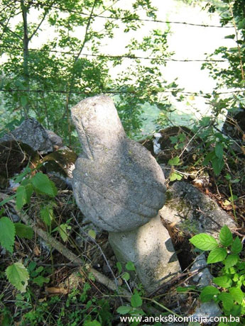
Part of
the harem, to the east of the mosque, contains six fairly old men’s nišan
tombstones with pleated turbans, without epitaphs, two of which have a hajji's
band carved on the tombstone below the turban (this zigzag line indicates that
the deceased had performed the pilgrimage).
The
eastern part of the harem also has ten nišan tombstones of recent date (latter
half of the 20th century) and four shahids' nišans dating from the 1992-1995
war.
Just 1.40
m from the north-west wall of the mosque was a 20 metre high sycamore tree(40), which was felled in 2008. The
surviving stump has a diameter of approx. 140 to 150 cm.
3. Legal status to date
The property
was listed in the Register of the Institute for the Protection of the Cultural
and Historical Heritage of BiH as the Mosque in the village
of Umoljani, Trnovo Municipality,
but was not on the Register of Protected Monuments of SR BiH.(41)
4. Research and conservation and
restoration works
Given its
previous status, there are no details of any research or conservation and
restoration works on the property.
The
sparse evidence in writing on the Umoljani mosque, and the account by residents
of the village, Bandić Omer (b. 1930) and Bandić Salko (b. 1949), have produced
the following information:
Bandić
Omer referred to his grandfather Bandić Salih (who died in 1940 at the age of
100) remembering a mosque built of wooden logs. This would indicate that in the
late 19th or early 20th century the timber walls of the mosque
were replaced by stone walls. It was probably at that time too that the stone
minaret was built.
According
to Bandić Omer himself, in 1930 Durak Elezović (from the hamlet of
Elezovići) continued work on the masonry of the minaret, but while doing so he
fell from the minaret and died as a result of the fall.
The
original roof cladding of shingles was replaced by tiles. Again according to
Bandić Omer of Umoljani (b. 1930), the tiles, which were brought from Konjic,
were laid in or about 1937, when a police station was built in Umoljani
and a fountain, known as “the pipe,” was installed in the village.
There is
a reference to the mosque in an article by Aljović Vejsil, published in 1966:
“In that chain of villages, one of the largest is the village of Umoljani,
where a mosque was built with a low wooden minaret rising above the mosque roof
like a somewhat wider chimney. The congregation say that anything taller and
slenderer would not survive the strong winds.”(42) He goes on to say in the same article that “a resident of
Lukavac, not far from Umoljani, brought water from a spring to the mosque, a
distance of about 50 m, at his own expense.”(43)
Bandić
Omer says that the minaret was clad with sheet metal in 1978-1979.
The
following works were carried out between 1997 and 2001:
replacement of the bearing wooden posts of the mahfil; replacement of the
wooden post that takes part of the load of the ceiling via a headtree and
joist; replacement of the wooden slatted ceiling and panelling installed;
replacement of the mahfil railing; replacement of the entrance door to the
mosque; replacement of part of the tiles. The calligraphic inscriptions on the
walls and in the mihrab niche also date from 1997-2001.
Since the
walls were whitewashed between 1997 and 2001, and the Commission is unaware
whether the calligraphic inscriptions that date from this period were preceded
by investigative works, soundings of the wall decorations would need to be
taken to ascertain if there were any earlier decorated layers or calligraphic
inscriptions.
5. Current condition of the
property
Structurally,
the property is in very good condition.
A letter(44) from the mayor of Trnovo states
that the roof of the mosque leaks, which could not be verified during the
on-site inspection, and there were no signs on the ceiling of possible damage
to the roof cladding.
The base
of the wooden mast of the minaret, at a height of approx. 30-40 cm, is rotten,
and the first two steps of the minaret have come away from their sockets.
The works
that have been carried out on the mosque in the past 50-60 years consist of
replacing the roof cladding of shingles with tiles; cladding the minaret with sheet
metal; replacing the mimber; replacing the wooden slats with panelling; fitting
panelling to the dado of the mihrab wall; fitting insulating glass in the
windows. These have resulted in the building losing some of its original
features. Some of these works are reversible, however.
Felling
the sycamore tree, which to judge from the diameter of the stump of 140-150 cm
(with a likely chest-high diameter of about 80-100 cm) must have been a couple
of hundred years old, has caused irreparable damage to the visual identity of
the architectural ensemble.
In 2007
work began on building a house about 20 m to the south of the mosque. In 2008,
at the initiative of the people of Umoljani and with the support of Trnovo Municipality,
this property was demolished. The ruins of the property and the surviving
concrete structure of the ground floor have yet to be removed.
III – CONCLUSION
Applying
the Criteria for the adoption of a decision on proclaiming an item of property
a national monument (Official Gazette of BiH nos. 33/02 and 15/03), the
Commission has enacted the Decision cited above.
The
Decision was based on the following criteria:
A. Time frame
C. Artistic and aesthetic value
C.vi. value of construction
D. Clarity
D.ii. evidence of historical change
D.iv. evidence of a particular type, style or
regional manner
D.v. evidence of a typical way of life at a
specific period
E. Symbolic value
E.ii. religious value
E.iii. traditional value
E.iv. relation to rituals or ceremonies
E.v. significance for the identity of a group of
people
F. Townscape/landscape value
F.i. relation to other elements of the site
F.iii. the building or group of buildings is part
of a group or site
G. Authenticity
G.iii. use and function
G.iv. traditions and techniques
G.v. location and setting
G.vi. spirit and feeling
G.vii. other internal and external factors
H. Rarity and representativity
H.i. unique or rare example of a certain type
or style
The
following documents form an integral part of this Decision:
-
Copy of cadastral plan
issued by the Department of Geodetics and Proprietary Rights Affairs, real
property cadastre and inspection supervision for town planning and building, 4
January 2007, c.p. no. 1311, c.m. Umoljani, title deed no. 263, plan no. 5,
Municipality Trnovo, Federation of Bosnia and Herzegovina, Bosnia and
Herzegovina
-
Land Register entry no.
SL/08 for plot no. c.p. 1311, c.m. Umoljani, property of the Trnovo Board of
the Islamic Community, issued by the Department of Geodetics and Proprietary
Rights Affairs, real property cadastre and inspection supervision for town
planning and building, Municipality Trnovo, Federation of Bosnia and Herzegovina,
Bosnia and Herzegovina
-
Photodocumentation
-
Photographs of the mosque
taken on 21 August 2008 by architect Emir Softić using Canon PowerShot A450
digital camera
-
Drawings
-
Ground plan of the mosque
and minaret with dimensions as measured on site; drawing of technical survey of
the property by Emir Softić, 21 August 2008
Bibliography
During
the procedure to designate the monument as a national monument of Bosnia
and Herzegovina the following works were
consulted:
1932. Popović, J. “Ljetni stanovi (mahale) na planini Bjelašnici”
(Summer residences [mahalas] on Mt Bjelašnica), Jnl of the National Museum,
(Natural History volumes), XLIV-1932
1966. Beširović, Uzeir. “Teferič na Slatini” (A Picnic at Slatina), Naše
planine, review of the Alpinists' Federation of Croatia
and Alpinists' Federation of Bosnia
and Herzegovina. Zagreb: 1966, no. 11-12
1966. Aljović, Vejsil. “Odrazi odanosti islamu vjernika u Umoljanima”
(Reverberations of Devotion of the Islamic Worshippers of Umoljani), Herald
of the Islamic Elders of SFRY, XXIX/1966, no. 11-12
1970. Aljović, Vejsil. “Reisu-ul-ulema po treći put gost umoljanskog
područja” (Reisu-l-ulema visits Umoljani for the third time), Herald of the
Islamic Elders of SFRY, XXXIII/1970, no. 9-10
1973. Basler, Đuro. Starine na Bjelašnici (Antiques on
Bjelašnica), 25th anniversary of the Bjelašnica Alpinists' Society. Sarajevo: 1973
1973. Popović, Đ, Cvetko. Stočne mahale na Bjelašnici (Grazing
Mahalas on Bjelašnica), 25th anniversary of the Bjelašnica Alpinists' Society. Sarajevo: 1973
1978. Kovačević, Ešref. Opširni popis bosanskog sandžaka 1488-89
(Detailed survey of the Bosnian sanjak, 1488-89), part II, Original: Istanbul, BBA TD 24,
transcript (unpublished m/s). Sarajevo:
Oriental Institute, 1978
1978. Opširni katastarski popis Kliškog sandžaka iz 1574. godine
(Detailed cadastral survey of the Klis sanjak of 1574), analyzed by Fehim
Dž.Spaho and Behija Zlatar. Sarajevo:
Oriental Institute, 1978
1984. Mihić, Ljubo J. Bjelašnica i Igman: planine Četrnaeste zimske
olimpijade (Bjelašnica and Igman: mountains of the 14th Winter Olympics).
Mostar: 1984
2001. Mulić, Jusuf. Konjic i njegova okolina u vrijeme Osmanske
vladavine (1463-1878) (Konjic and its Environs during the Ottoman Period). Sarajevo: 2001
2005. Babić, Braco, Bozja, Drago. Planinarsko-turistički vodič po
planinama oko Sarajeva (Alpinist and Tourist Guide of the Mountains around Sarajevo). Sarajevo: Fondacija za
zaštitu Bjelašnice, Igmana, Treskavice i kanjona Rakitnice, 2005
2007. Opširni popis Kliškog sandžaka iz 1550. godine (Detailed
census of the Klis sanjak of 1550) analyzed by Fehim Dž. Spaho, Ahmed S. Aličić;
ed. Behija Zlatar. Sarajevo: Oriental Institute,
2007 (Sarajevo:
Bemust). - XXII, 470 p.; 29 cm. - (Monumenta Turcica. Historiam slavorum
meridionalium illustranti ; Ser. 2 T12, Defteri; bk. 5) Based on: Defter-i
mufassal-i Liva-i Klis.
2007. Fekeža, Lidija. “Srednjovjekovna nekropola u Šabićima” (The
Mediaeval Necropolis in Šabići), Annual of the Centre for Balkan Studies,
vol. XXXVI. Sarajevo: Academy of Sciences and
Arts of Bosnia and
Herzegovina, 2007
2008. Ahmed S. Aličić. Sumarni popis sandžaka Bosna iz 1468/69.
godine (Summary census of the sanjak of Bosnia for 1468/69), deciphered and
translated from Ottoman Turkish, with a scholarly analysis, and prepared for
the press by Ahmed S. Aličić. Mostar: Islamic Cultural Centre, 2008 ([s.l. :
s.n.]). –XXVIII
2008 Record of the epigraphic material of the architectural ensemble
of the mosque in Umoljani, studied, recorded and processed by Hazim Numanagić,
orientalist and calligrapher of Sarajevo,
on 3 September 2008
Website
of the Majlis of the Islamic Community of Sarajevo, http://www.medzlis-sa.ba/
(1) Karlo Pasch,
“Rimska mjesta u konjičkom kotaru,” Jnl of the Provincial Museum, A, Sarajevo: 1902, 331.
(2) The
Črešnjevo fort in the Trešanica valley, with the town on its outskirts known as
Neretva on the right bank of the river Neretva (in present-day Konjic)
flourished during the 15th century
(3) Popović, Đ,
Cvetko, Stočne mahale na Bjelašnici, 25th anniversary of the Bjelašnica
Alpinists' Society, Sarajevo:
1973, 95.
(4) The leader
of a Vlach caravan was known as kramar
(5) There are
the unexcavated remains of a mediaeval church on the site (Fekeža, Lidija, “Srednjovjekovna
nekropola u Šabićima,” Annual, Centre for Balkan Studies, vol. XXXVI, Sarajevo: Academy
of Sciences and Arts of Bosnia and Herzegovina,
2007, 213)
(6) Fekeža,
Lidija, “Srednjovjekovna nekropola u Šabićima,” Annual, Centre for
Balkan Studies, vol. XXXVI, Sarajevo: Academy of Sciences
and Arts of Bosnia and Herzegovina,
2007, 191-220
(7) Ahmed S.
Aličić, Sumarni popis sandžaka Bosna iz 1468/69. godine, deciphered and
translated from Ottoman Turkish, with a scholarly analysis, and prepared for the
press by Ahmed S. Aličić; Mostar: Islamski kulturni centar, 2008, 95
(8) “Vojnuk
– member of a military rank in the Ottoman Empire,
recruited in the Balkans from the local non-Muslim population, mainly the
Vlachs. They were rewarded for their services, which consisted of guarding
forts, especially in frontier regions, by the freedom to inherit hereditaments,
and were exempt from all state and feudal taxation.” (Opširni popis Kliškog
sandžaka iz 1550. godine, analyzed by Fehim Dž. Spaho, Ahmed S. Aličić; ed.
Behija Zlatar.. - Sarajevo: Oriental Institute,
2007 (Sarajevo:
Bemust). - XXII, 470 p.; 29 cm. - (Monumenta Turcica. Historiam slavorum
meridionalium illustrantia; Ser. 2 T12, Defteri; bk. 5) From: Defter-i
mufassal-i Liva-i Klis, Glossary of Terms, p. 470)
(9) Kovačević,
Ešref, Opširni popis bosanskog sandžaka 1488-89/part II, Original: Istanbul, BBA TD 24, Transcript (unpublished m/s, Oriental
Institute, Sarajevo, Sarajevo, 1978
(10) Opširni
popis Kliškog sandžaka iz 1550. godine, analyzed by Fehim Dž. Spaho, Ahmed
S. Aličić; ed. Behija Zlatar.. - Sarajevo:
Oriental Institute, 2007 (Sarajevo:
Bemust). - XXII, 470 p.; 29 cm. - (Monumenta Turcica. Historiam slavorum
meridionalium illustrantia; Ser. 2 T12, Defteri; knj. 5) From: Defter-i
mufassal-i Liva-i Klis, p. 318-324
(11) “The poll
tax paid in cash to the spahi by the Muslim raja amounted to 22 akča.” (Opširni
popis Kliškog sandžaka iz 1550. godine, analyzed by Fehim Dž. Spaho, Ahmed
S. Aličić; ed. Behija Zlatar.. - Sarajevo:
Oriental Institute, 2007 (Sarajevo:
Bemust). - XXII, 470 p.; 29 cm. - (Monumenta Turcica. Historiam slavorum
meridionalium illustrantia; Ser. 2 T12, Defteri; knj. 5) From: Defter-i mufassal-i
Liva-i Klis, Rječnik termina, p. 469)
(12) “The raja
poll tax paid by the non-Muslim raja to the spahi amounted to 25 akča per head
for men. It was also paid by non-Muslims who held lands registered in the
defters to Christians.” (Opširni popis Kliškog sandžaka iz 1550. godine,
analyzed by Fehim Dž. Spaho, Ahmed S. Aličić; ed. Behija Zlatar.. - Sarajevo: Oriental Institute, 2007 (Sarajevo: Bemust). - XXII, 470 p.; 29 cm. -
(Monumenta Turcica. Historiam slavorum meridionalium illustrantia ; Ser. 2 T12,
Defteri ; bk. 5) From: Defter-i mufassal-i Liva-i Klis, Glossary of Terms, p.
467)
(13) “Member of
a military rank in the Ottoman Empire in the frontier sanjaks in Europe. An akindžija was a light cavalryman. These
troops, composed of Ottomans and local Muslim and non-Muslims, were used for incursions
into enemy territory. For this reason they were allocated timars or free
hereditaments.” (Opširni popis Kliškog sandžaka iz 1550. godine,
analyzed by Fehim Dž. Spaho, Ahmed S. Aličić; ed. Behija Zlatar.. - Sarajevo: Oriental Institute, 2007 (Sarajevo: Bemust). - XXII, 470 p.; 29 cm. -
(Monumenta Turcica. Historiam slavorum meridionalium illustrantia; Ser. 2 T12,
Defteri; knj. 5) From: Defter-i mufassal-i Liva-i Klis, Glossary of Terms, p.
463)
(14) “A complex
of land-holdings in the possession of a single peasant family and large enough
to maintain it.” (Opširni popis Kliškog sandžaka iz 1550. godine,
analyzed by Fehim Dž. Spaho, Ahmed S. Aličić; ed. Behija Zlatar.. - Sarajevo: Oriental Institute, 2007 (Sarajevo: Bemust). - XXII, 470 p.; 29 cm. -
(MonumentaTurcica. Historiam slavorum meridionalium illustrantia; Ser. 2 T12,
Defteri; bk. 5) From: Defter-i mufassal-i Liva-i Klis, Glossary of Terms, p.
463)
(15) “A type of
holding with a specific economic and legal status differing from other rights
to land. It was a distinct economic and
territorial entity with its own boundaries, but its size was not unlimited. It
could consist of one hereditament and several villages. The essential
difference in economic and legal terms from peasant landholdings was its higher
level of proprietorship.” (Opširni popis Kliškog sandžaka iz 1550.
godine, analyzed by Fehim Dž. Spaho, Ahmed S. Aličić; ed. Behija Zlatar.. - Sarajevo: Oriental Institute, 2007 (Sarajevo: Bemust). - XXII, 470 p.; 29 cm. -
(Monumenta Turcica. Historiam slavorum meridionalium illustrantia; Ser. 2 T12,
Defteri; bk. 5) From: Defter-i mufassal-i Liva-i Klis, Glossary of Terms, p.
463)
(16) Opširni
katastarski popis Kliškog sandžaka iz 1574. godine / analyzed by Fehim
Dž.Spaho and Behija Zlatar, Sarajevo:
Oriental Institute, 1978
(17) The time
when the mevlud was held in Umoljani was associated with the agricultural
cycle. It was held in July or August at a time when the local residents had
some free time. This in turn was dictated by this harsh mountain climate, which
meant that the date of the mevlud had to be flexible to allow for the changing
weather conditions (information from Mujo Sušić, a teacher at the Gazi
Husrev-bey medresa in Sarajevo.
(18) The
reference is to the visit by Reis-ul-ulema Hajji Sulejman ef. Kemura to
Umoljani on 9 August 1970 (note: Emir Softić)
(19) Aljović,
Vejsil, “Reis-ul-ulema po treći put gost umoljanskog područja,” Herald of
the Islamic Elders of SFRY
XXXIII/1970, no. 9-10, 503
(20) Aljović,
Vejsil, “Odrazi odanosti islamu vjernika u Umoljanima,” Herald of the
Islamic Elders of SFRY XXIX/1966, no. 11-12, 586. The article does not give
the dates when the carpets and money were given to the mosque, or when the land
was donated or the water pipes laid, but it must obviously have been before
1966 (Emir Softić)
(21) Length of
the south-east wall, as measured
(22) Length of
the north-west wall, as measured
(23) The
north-east wall is approx. 14.10 m long; together with the entrance portico,
the overall length is approx. 15.55 m.
(24) No
information on the date of this extension is available
(25) The
reference point is ground level outside the entrance to the mosque
(26) Qur’an,
2:144
(27) 1997-2001
(28) The
daylight height from floor level in the central prayer hall to the underside of
the joist is a mere 1.65 m (note: Emir Softić)
(29) The
presence of these openings in the wall, and the unusual feature of the absence
of windows in the present wall of the entrance façade (the north-west wall),
suggest that the mosque may at one time have had a kind of portico that was
later walled in to turn it into a vestibule. Both the door (118 x 156 cm) and
the openings in this wall (35 x 35 cm with the sill at 78 cm and 50 x 34 cm
with the parapet at 86 cm) are very small (the masonry openings of the windows
in the other walls – width x height – are 47/55, 54/63, 56/84, 47/55, 60/70,
56/84 cm), probably in an attempt to keep the cold out, since this side of the
mosque faces the prevailing wind (note: Emir Softić). The specific features of
the climatic area where Umoljani is located make this likely. The mean annual
temperature on Bjelašnica is 0.7°C, the maximum temperature is 24°C, and the
lowest is -41°C. In winter the snow-cover is one to three metres deep, with drifts
of more than four metres. Strong winds and thunderstorms, and sudden weather
changes, are a feature of Bjelašnica.
Another feature suggesting that the vestibule was formerly part of
a portico is the vestibule floor, consisting of cement screed.
(30)
Translator’s note: in the original the words literally translated here as “overlapping
carpentry joints” are between quotation marks, as is the word translated as
“truss.” It is not clear from the description why this should be so, except
perhaps to suggest that the terms are not being used in their true meaning.
(31) The
trusses consist of a basal truss beam of approx. 16 x 16 cm in section, posts
of approx. 12 x 18 cm in section, braces of approx. 12 x 18 cm in section, and
a top truss beam of approx. 12 x 16 cm in section. The joints of the posts, braces and beams are
reinforced with cramps (note: Emir Softić)
(32) These
joists are set at the same level as the roof trusses
(33) Measured
from the point at which one enters the minaret, which is level with the mahfil
floor (note: Emir Softić)
(34) Height of
the bottom edge of the openings above the point at which one enters the
minaret, level with the mahfil floor
(35) Measured
from the point at which one enters the minaret, level with the mahfil floor
(36)
(4.95-3.80=1.15 m)
(37) The
average height of an adult male in BiH is approx. 175-180 cm
(38) Measured
from the point at which one enters the minaret, level with the mahfil floor
(39) The way in
which it juts out strongly suggests that it bears an inscription of some kind
(note: Emir Softić).
(40) Acer
pseudoplatanus (L.)
(41) Letter no.
07-40-4-186-1/08, of 15.01.2008, Institute for the Protection of Monuments of
the Federal Ministry of Culture and Sport, Sarajevo
(42) Aljović,
Vejsil, “Odrazi odanosti islamu vjernika u Umoljanima,” Herald of the
Islamic Elders of SFRY XXIX/1966, no. 11-12, 585
(43) Aljović,
Vejsil, 1966, 586
(44) Letter
from Trnovo Municipality, no. 02/2-23-80, of
04.01.2008.
|