Status of monument -> National monument
Published in the Official Gazette of BiH, no. 53/08.
Pursuant to Article V para. 4 Annex 8 of the General Framework Agreement for Peace in Bosnia and Herzegovina and Article 39 para. 1 of the Rules of Procedure of the Commission to Preserve National Monuments, at a session held from 25 March to 1 April 2008 the Commission adopted a
D E C I S I O N
I
The historic site of the old Kamengrad fort in Sanski Most is hereby designated as a National Monument of Bosnia and Herzegovina (hereinafter: the National Monument).
The National Monument is located on a site designated as part of cadastral plot no.2061, Land Register entry no. 162, cadastral municipality Donji Kamengrad, Municipality Sanski Most, Federation of Bosnia and Herzegovina, Bosnia and Herzegovina.
The provisions relating to protection measures set forth by the Law on the Implementation of the Decisions of the Commission to Preserve National Monuments, established pursuant to Annex 8 of the General Framework Agreement for Peace in Bosnia and Herzegovina (Official Gazette of the Federation of BiH nos. 2/02, 27/02, 6/04 and 51/07) shall apply to the National Monument.
II
The Government of the Federation of Bosnia and Herzegovina (hereinafter: the Government of the Federation) shall be responsible for providing the legal, scientific, technical, administrative and financial measures necessary for the protection, conservation, and presentation of the National Monument.
The Commission to Preserve National Monuments (hereinafter: the Commission) shall determine the technical requirements and secure the funds for preparing and erecting signboards with basic details of the monument and the Decision to proclaim the property a National Monument.
III
To ensure the on-going protection of the National Monument on the area defined in Clause 1 para. 2 of this Decision, the following protection measures are hereby stipulated:
- all works are prohibited other than research and conservation and restoration works, including works designed to display the monument, subject to the approval of the Federal Ministry responsible for regional planning and under the expert supervision of the heritage protection authority of the Federation of Bosnia and Herzegovina.
To ensure the on-going protection of the National Monument, the following works shall be carried out:
- clearing the ramparts, walls of the towers and other areas of vegetation presenting a danger to the structure of the monument,
- structural repairs to the towers and ramparts where they are at risk of collapse,
- during structural repair, conservation and restoration works, original materials and binders shall be used wherever possible,
- during repair works the existing stone blocks shall be used,
- such components of dressed stone as are missing must be replaced by new ones made of the same material as the original,
- the finish of the areas of repaired walls should match that of the rest of the wall,
- the crown of the wall must be composed of natural materials (coping stones or a finish of hydraulic mortar),
- major cracks must be filled with a compound of small pieces of stone and hydraulic lime mortar,
- a programme for the presentation of the National Monument shall be drawn up and implemented,
- the site of the National Monument shall be cleared, and shall be open and accessible to the public; it may be used for educational and cultural purposes.
The buffer zone consists of an area with a radius of 150 m from the boundaries of Protection Zone I.
The following measures shall apply to the buffer zone:
- only construction of residential buildings with a maximum height of 6.50 m. to the base of the roof structure, i.e. ground + 1, and maximum dimensions of 10 x 12 metres, shall be permitted,
- the construction of major infrastructure or power-supply facilities is prohibited, as is the construction of industrial plant and facilities for the extraction of stone or other environmental polluters the construction or operation of which could be detrimental to the National Monument,
- the dumping of all kinds of waste is prohibited.
IV
All executive and area development planning acts not in accordance with the provisions of this Decision are hereby revoked.
V
Everyone, and in particular the competent authorities of the Federation of Bosnia and Herzegovina, the Canton, and urban and municipal authorities, shall refrain from any action that might damage the National Monument or jeopardize the preservation and rehabilitation thereof.
VI
The Government of the Federation, the Federal Ministry responsible for regional planning, the Federation heritage protection authority, and the Municipal Authorities in charge of urban planning and land registry affairs, shall be notified of this Decision in order to carry out the measures stipulated in Articles II to V of this Decision, and the Authorized Municipal Court shall be notified for the purposes of registration in the Land Register.
VII
The elucidation and accompanying documentation form an integral part of this Decision, which may be viewed by interested parties on the premises or by accessing the website of the Commission (http://www.aneks8komisija.com.ba)
VIII
Pursuant to Art. V para 4 Annex 8 of the General Framework Agreement for Peace in Bosnia and Herzegovina, decisions of the Commission are final.
IX
This Decision shall enter into force on the date of its adoption and shall be published in the Official Gazette of BiH.
This Decision has been adopted by the following members of the Commission: Zeynep Ahunbay, Amra Hadžimuhamedović, Dubravko Lovrenović, Ljiljana Ševo and Tina Wik.
No.05.1-2-160/07-6
29 March 2008
Sarajevo
Chair of the Commission
Amra Hadžimuhamedović
E l u c i d a t i o n
I – INTRODUCTION
Pursuant to Article 2, paragraph 1 of the Law on the Implementation of the Decisions of the Commission to Preserve National Monuments, established pursuant to Annex 8 of the General Framework Agreement for Peace in Bosnia and Herzegovina, a “National Monument” is an item of public property proclaimed by the Commission to Preserve National Monuments to be a National Monument pursuant to Articles V and VI of Annex 8 of the General Framework Agreement for Peace in Bosnia and Herzegovina and property entered on the Provisional List of National Monuments of Bosnia and Herzegovina (Official Gazette of BiH no. 33/02) until the Commission reaches a final decision on its status, as to which there is no time limit and regardless of whether a petition for the property in question has been submitted or not.
On 7 September 2007 the Institute for the Protection of the Cultural Heritage, Bihać, submitted a proposal/petition to designate the historic site of the old Kamengrad fort as a national monument of Bosnia and Herzegovina.
Pursuant to the provisions of the law, the Commission proceeded to carry out the procedure for reaching a final decision to designate the Property as a National Monument, pursuant to Article V para. 4 of Annex 8 and Article 35 of the Rules of Procedure of the Commission to Preserve National Monuments.
II – PROCEDURE PRIOR TO DECISION
In the procedure preceding the adoption of a final decision to proclaim the property a national monument, the following documentation was inspected:
- Documentation on the location and current owner and user of the property (copy of cadastral plan and copy of land register entry);
- Data on the current condition and use of the property, including a description and photographs, data of war damage, data on restoration or other works on the property, etc;
- Historical, architectural and other documentary material on the property, as set out in the bibliography forming part of this Decision.
The findings based on the review of the above documentation and the condition of the property are as follows:
1. Details of the property
Location
The Kamengrad fort is above the village of Donji Kamengrad, at an altitude of 417 m, about 9 km from Sanski Most.
The National Monument is located on a site designated as cadastral plot no. 2061 (part), Land Register entry no. 162, cadastral municipality Donji Kamengrad, Municipality Sanski Most, Federation of Bosnia and Herzegovina, Bosnia and Herzegovina.
Historical information
The remains of the old Kamengrad fort can be seen on the hill above the village of Donji Kamengrad. The earliest reference to the mediaeval fort is on 3 May 1374 in a contract of sale between local magnates (Kreševljaković, 1959, 21). In translation, the contract reads: “The chapter of the church of Zagreb certifies that Juraj, son of Toma, Jakša son of Petar, and Dragoš, son of Radosav of old Vrsušje have before this chapter sold a part of their estate of Zagradje by the castle (castrum) of Master Ivan, son of the late knez (prince) Dujam Blagajski and his brothers, known as Kamengrad, to the said Master Ivan, Nikola, Babonigo and Stefan, sons of the late Dujam . . for ten marca of royal dinars. Dated this day of Feast of the Holy Cross 1374.” (Kreševljaković, 1959, 21, 22). Since the entire area is rich in iron ore, it has been inhabited without a break for many centuries.
The earliest remains of prehistoric life are to be found in the immediate vicinity, in the Hrastovača cave, south of Sanski Most. Material remains from the prehistoric period and antiquity have been found in the environs of Stari Majdan. Sites at Oštra Luka, Stara Rijeka belong to a similar cultural stratum, and are associated with the dense network of roads that facilitated the more effective exploitation of iron ore. There is little information between the date of origin of Kamengrad, 1374, and 1499 when the area came under Ottoman rule.
According to H. Kreševljaković, the fort was built in 1346, and was taken in 1463 (Kreševljaković, H, 1953, 28). A tradition has survived to the effect that the Ottomans besieged Kamengrad for a full eleven years, finally conquering it only when Sultan Fatih and his army joined them on the battlefield. A Musalla(1) was then erected in his name. This tradition was first related by Benedikt Kuripešić in his travelogue of 1530.
After the fall of the fort, military and political activity was stepped up, on account of the highly strategic position of Kamengrad.
Once they had conquered Kamengrad, the Ottomans made it the seat of a nahija, an administrative district belonging to the Sana župa (county). A garrison under the command of a dizdar was housed in the fort, and the policing of the settlement on the outskirts was initially the responsibility of a subaša and later a vojvoda (military leader). The earliest reference to the county of Sana in historical sources dates from 1256, in a document of the Ston-Belgrade chapter which refers to Aleksandar as “comes de Zana,” along with Mojsije as “comes de Vrbas” (Mrgić-Radojčić, 2002, 244). In 1280 the Lord of the County of Vrbas and Sana was Ivan of Gising, but by 1285 he had been succeeded by Radoslav Babonjić “lord of Glaž, Vrbas and Sana.” Interestingly, between 1280 and 1283 the counties of Sana and Vrbas feature in Dubrovnik sources 18 and 12 times respectively as the native regions of slaves being sold in Dubrovnik, suggesting that much of the population of these counties was unbaptised (Mrgić-Radojčić, 2002, 244).
There are no surviving sources in which the boundaries of the county of Sana are described. A census of Catholic parishes in the Zagreb bishopric drawn up in 1334 lists the following identifiable parishes in the Sanski district: Puharska, Kozara (Kozarac), Pobriježje, Oštra Luka, Vrsušje (now the village of Vrše, about 3 km north of Kamengrad), Mrin, Blagaj, Vodica, Japra and Trgovište (Mrgić-Radojčić, 2002, 244).
Somewhat later, in or around 1541, the Kamengrad kadiluk was founded, which seemingly initially covered the area that was until recently the kotar or srez (district) of Sanski Most. From 1565 to the mid 17th century its area extended all the way to Cetingrad. The nahijas of Ključ and Bilaj probably also belonged to this kadiluk in the mid 16th century(2). At the end of the 16th century Kamengrad was in the Bosnian sanjak, and later, until after 1626, in the Bihać sanjak (Kreševljaković, 28, 1959).
In early Ottoman times, the “old iron mine that was exploited even before the Ottomans,” near the Kamengrad fort in the village of Glogovica, was a major mine in the early Ottoman period, producing cannon balls, bullets and tools. It is no longer possible to locate this site with certainty, but it was probably close to the village of Majdankići, a few kilometres north-west of Kamengrad (Mrgić-Radojčić, 2002, 276).
Kamengrad began to decline in importance with the fall of Bosanska Krupa in 1564.
In 1624, Kamengrad became the seat of a captaincy, to which the small towns of Stari Majdan and Vakuf (Sanski Most) also belonged. This lead to something of a revival of the fort.
The town declined in the late 17th century, when the seat of the kadi (judge) and captain was transferred to Majdan.
It would seem that the Catholic parish of Kamengrad was in existence from the 14th to the 18th century. A census by the Zagreb bishopric dating from 1335 refers to the parish of Cramen (? Kamen). This, Dr. P. Matković believes, could later have been the parish of Kamengrad (Kreševljaković, 31, 1959), which was merged with the parish in Stari Majdan in or around 1655. After the Vienna war (1683-1699) all trace of this parish vanishes.
Various foreign sources refer to Kamengrad in different ways: Kamengrad, Camengrad, Kamingrad, Kamergraid, Camengrae. It also features under the Hungarian names of Kewar, Kywwar and Chivar. It is invariably spelled Kamengrad in Turkish sources (Kreševljaković, 33, 1959).
2. Description of the property
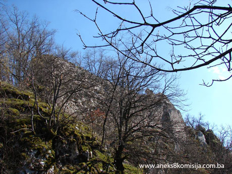
The Kamengrad fort occupies the maximum space allowed by the lie of the land. The upper fort has an area of approx. 4,000 m2. No detailed description of Kamengrad has ever been composed, nor has the fort been surveyed in detail. Most of it is overgrown with thick vegetation.
Kreševljaković relates that a good paved road about 4 m wide once led from the village of Donji Kamengrad to the fort. ”This road is the only way to reach the fort, since the crag on which it stands falls away precipitously on the other three sides, almost vertically to the plain. A fair amount of the walls of the old fort have survived, up to as much as 8 m in height in places, and one round tower, the shape of which tells us that it was built before the 15th century.” (Kreševljaković, 631, 1991).
There are now no remains of the paving; though there are signs of a road leading to the lower fort, it is impossible to say whether this was the road Kreševljaković meant in his description or some other road.
A forest track west of the fort, close to a former quarry, climbs gradually to the fort, with the slope beginning very close to the Kamengrad musalla.
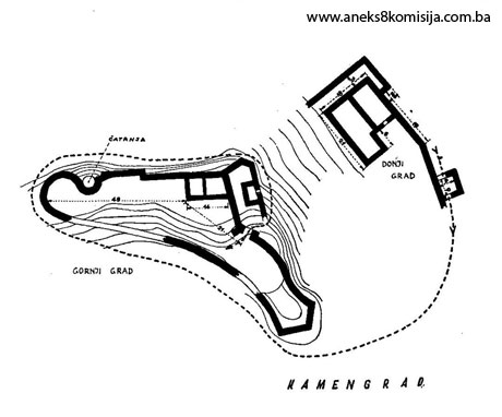
Kamengrad is irregular in plan, as dictated by the lie of the land where it was built(3). The layout is perfectly adapted to the site, and consists of two parts:
- the upper fort, standing at the top of a rocky bluff – this section is known locally as the ”Kaja“ fort (kaja = crag, bluff), and
- the lower fort or outskirts, at the foot of the bluff – this part is known locally as Palanka (= permanently entrenched camp attached to a Turkish frontier fortress)
The upper fort is about 100 m long and 25 m wide, with the entrance on the north-east side, leading into a 12 m wide courtyard. Truhelka marked four structures in this central part of the fort, of which no remains can now be seen.
In addition to the perimeter ramparts, the entrance to the fort was protected from the north-east by a polygonal tower. There is another projecting square semi-tower in the north wall(4).
On the west side of the fort is a semicircular tower, with a depth of the rounded section of about 7 cm. In his drawing, Truhelka marked a well very close to this tower (about 3 metres away), but there is now no sign of this. The same drawing shows that there were also ramparts to the south of the fort, but there is now no sign of them, or any signs there may be cannot be seen because of the luxuriant vegetation covering the site.
On the south-east side of the fort is a polygonal guard tower, visible from below. On the south side of this tower is an opening 50 cm wide and 80 cm high, ending in a semicircular segmental arch. The inside of the tower is semicircular, and the entire space is full of material and piled-up earth, so that it is impossible to say whether it had more than one storey.
The entire fort was built of quarry stone with lime mortar as binder. This must have been hydraulic lime, since there are visible signs on the walls of the fort of red binder matter trickling down, deriving from the silicate component of the binder.
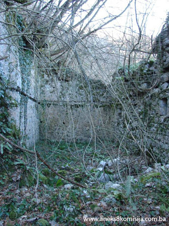
The lower fort is at the foot of the bluff, and consists of a system of ramparts within which are a few buildings (three larger and a few smaller ones). These measure 21 x 9 and 18 x 8 m, all are rectangular in plan, and are built of hewn stone laid on lime mortar. All the buildings were built with fairly regular angles and straight sides, the workmanship is neater, and the openings for the wooden beams are equidistant, suggesting that they are of later date.
According to Truhelka’s drawing, there was a path in the southern part of the lower fort, leading to the upper fort(5).
3. Legal status to date
According to the Institute for the Protection of Monuments of the Federal Ministry of Culture and Sport, the historic site of the old Kamengrad fort is listed under the heading: Ruins of the mediaeval fort of Kamengrad in Donji Kamengrad, Sanski Most.
The property was protected by the Institute for the Protection of the Cultural, Historical and Natural Heritage of BiH by Ruling no. 904/51 of 24 October 1951.
The Regional Plan of Bosnia and Herzegovina to 2000, Stage B, Valorization, compiled in 1980, listed the old Kamengrad fort, Sanski Most as a Category III monument.
4. Research and conservation and restoration works
According to the available information, no research or conservation and restoration works have ever been carried out on the site.
5. Current condition of the property
The findings of an on-site inspection conducted on 3 March 2008 were as follows:
- the access road to the fort is in very poor condition;
- part of the access road leading from the Kamengrad Musalla has been damaged by the quarry workings;
- the ramparts to the north-east of the fort are in very poor condition;
- the crowns of the walls have been damaged, as a result of which rainwater has penetrated, causing the stone cladding to fall away from the wall mass;
- much of the material – stone blocks – is on the outskirts of the fort, to the north;
- the site is overgrown with self-sown vegetation.
6. Specific risks
- lack of maintenance,
- self-sown vegetation.
III – CONCLUSION
Applying the Criteria for the adoption of a decision on proclaiming an item of property a national monument (Official Gazette of BiH nos. 33/02 and 15/03), the Commission has enacted the Decision cited above.
The Decision was based on the following criteria:
A. Time frame
B. Historical value
C. Artistic and aesthetic value
C.iv. composition
D. Clarity (documentary, scientific and educational value)
D.ii. evidence of historical change
D.iv. evidence of a particular type, style or regional manner
G. Authenticity
G.v. location and setting
The following documents form an integral part of this Decision:
- Copy of cadastral plan;
- Photodocumentation:
- Institute for the Protection of Monuments of Una-Sana Canton,
- Commission to Preserve National Monuments – photographs taken by Mirzah Fočo using SONY digital camera;
- Drawings.
Bibliography
During the procedure to designate the monument as a national monument of Bosnia and Herzegovina the following works were consulted:
1959. Kreševljaković, Hamdija. Naše starine VI. Sarajevo: 1959
1991. Kreševljaković, Hamdija. Izabrana djela II, Kamengrad (Selected Works II, Kamengrad). Sarajevo: Veselin Masleša, 1991.
2002 Mrgić-Radojčić, Jelena. Donji Kraji, Krajina srednjovekovne Bosne (Donji Kraji, A Frontier Region of Mediaeval Bosnia). Belgrade, 2002.
Documentation of the Institute for the Protection of Monuments of Una-Sana Canton
(1) The architectural ensemble of Musalla with burial ground in Kamengrad, Municipality Sanski Most, was designated as a national monument at the 9th session of the Commission to Preserve National Monuments, held from 1 to 7 July 2003
(2) The kadiluk was divided into six nahijas
(3) Ćiro Truhelka drew the ground plan of Kamengrad, but it has never been published
(4) A semitower is basically a tower occupying a semicircle
(5) During the on-site visit, the precipitous nature of the bluff meant that no evidence for this could be found
|