Status of monument -> National monument
Published in the “Official Gazette of BiH” no. 43/08.
Pursuant to Article V para. 4 Annex 8 of the General Framework Agreement for Peace in Bosnia and Herzegovina and Article 39 para. 1 of the Rules of Procedure of the Commission to Preserve National Monuments, at a session held from 29 January to 4 February 2008 the Commission adopted a
D E C I S I O N
I.
The historic site of the Srednje necropolis with stećak tombstones, municipality Ilijaš, is hereby designated as a National Monument of Bosnia and Herzegovina (hereinafter: the National Monument).
The National Monument consists of a necropolis with fifteen stećak tombstones.
The National Monument is located on a site designated as cadastral plot no.739/11, title deed no. 205, Land Register entry no.542, and part of c.p. no. 739/9, Land Register entry no. 542, cadastral municipality Srednje, Municipality Ilijaš, Federation of Bosnia and Herzegovina, Bosnia and Herzegovina.
The provisions relating to protection measures set forth by the Law on the Implementation of the Decisions of the Commission to Preserve National Monuments, established pursuant to Annex 8 of the General Framework Agreement for Peace in Bosnia and Herzegovina (Official Gazette of the Federation of BiH nos. 2/02, 27/02, 6/04 and 51/07) shall apply to the National Monument.
II.
The Government of the Federation of Bosnia and Herzegovina (hereinafter: the Government of the Federation) shall be responsible for providing the legal, scientific, technical, administrative and financial measures necessary to protect, conserve, and display the National Monument.
The Commission to Preserve National Monuments (hereinafter: the Commission) shall determine the technical requirements and secure the funds for preparing and erecting signboards with basic details of the monument and the Decision to proclaim the property a National Monument.
III.
To ensure the on-going protection of the National Monument on the site defined in Clause 1 para. 3 of this Decision, the following protection measures are hereby stipulated:
- all works are prohibited other than conservation and restoration works, including those designed to display the monument, with the approval of the Federal Ministry responsible for regional planning (hereinafter: the relevant ministry) and under the expert supervision of the heritage protection authority of the Federation of Bosnia and Herzegovina (hereinafter: the heritage protection authority),
- works on the infrastructure are permitted only with the approval of the relevant ministry and subject to the expert opinion of the heritage protection authority,
- all building and works of any kind that could have the effect of altering the site or the area are prohibited, as is the erection of temporary or permanent structures not designed solely to protect and present the National Monument,
- the dumping of all kinds of waste is prohibited.
IV.
All executive and area development planning acts not in accordance with the provisions of this Decision are hereby revoked.
V.
Everyone, and in particular the competent authorities of the Federation of Bosnia and Herzegovina, the Canton, and urban and municipal authorities, shall refrain from any action that might damage the National Monument or jeopardize the preservation thereof.
VI.
The Government of the Federation, the Federal Ministry responsible for regional planning, the Federation heritage protection authority, and the Municipal Authorities in charge of urban planning and land registry affairs, shall be notified of this Decision in order to carry out the measures stipulated in Articles II to V of this Decision, and the Authorized Municipal Court shall be notified for the purposes of registration in the Land Register.
VII.
The elucidation and accompanying documentation form an integral part of this Decision, which may be viewed by interested parties on the premises or by accessing the website of the Commission (http://www.aneks8komisija.com.ba)
VIII.
Pursuant to Art. V para 4 Annex 8 of the General Framework Agreement for Peace in Bosnia and Herzegovina, decisions of the Commission are final.
IX.
This Decision shall enter into force on the date of its adoption and shall be published in the Official Gazette of BiH.
This Decision has been adopted by the following members of the Commission: Zeynep Ahunbay, Amra Hadžimuhamedović, Dubravko Lovrenović, Ljiljana Ševo and Tina Wik.
No: 02.2-227/07-9
30 January 2008
Sarajevo
Chair of the Commission
Amra Hadžimuhamedović
E l u c i d a t i o n
I – INTRODUCTION
Pursuant to Article 2, paragraph 1 of the Law on the Implementation of the Decisions of the Commission to Preserve National Monuments, established pursuant to Annex 8 of the General Framework Agreement for Peace in Bosnia and Herzegovina, a “National Monument” is an item of public property proclaimed by the Commission to Preserve National Monuments to be a National Monument pursuant to Articles V and VI of Annex 8 of the General Framework Agreement for Peace in Bosnia and Herzegovina and property entered on the Provisional List of National Monuments of Bosnia and Herzegovina (Official Gazette of BiH no. 33/02) until the Commission reaches a final decision on its status, as to which there is no time limit and regardless of whether a petition for the property in question has been submitted or not.
On 25 December 2002 Ilijaš Municipality submitted a proposal/petition to designate the necropolis with stećak tombstones in Srednje as a national monument of Bosnia and Herzegovina.
Pursuant to the provisions of the law, the Commission proceeded to carry out the procedure for reaching a final decision to designate the Property as a National Monument, pursuant to Article V para. 4 of Annex 8 and Article 35 of the Rules of Procedure of the Commission to Preserve National Monuments.
II – PROCEDURE PRIOR TO DECISION
In the procedure preceding the adoption of a final decision to proclaim the property a national monument, the following documentation was inspected:
- Documentation on the location and the current owner and user of the property (copy of cadastral plan and Land Register entry);
- The current condition and use of the property, including a description and photographs, data of war damage, data on restoration or other works on the property, etc.;
- Historical, architectural and other documentary material on the property, as set out in the bibliography forming part of this Decision.
The findings based on the review of the above documentation and the condition of the site are as follows:
1. Details of the property
Location
The village of Srednje is in the river Ljubina valley, on the Sarajevo-Semizovac-Olovo road, in Ilijaš Municipality. It is about 16 km as the crow flies to the north-east of the town of Ilijaš.
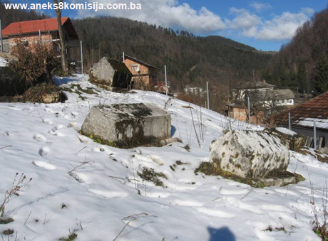
Here there is a necropolis with stećak tombstones on the right bank of the river Ljubina, behind the harem of the mosque, in the village itself. The site contains 15 stećak tombstones, nine gabled and 6 chest-shaped. They are of very good workmanship and well preserved, though some have partly or wholly sunk into the ground.
The tombstones lie north-south, some with slight deviations to the north-east/south-west, apart from two that lie west-east. They are in rows, and have no decorations. The necropolis covers an area of 130 sq.m(1) and is in the sole ownership of the vakuf of the mosque in Srednje.
The National Monument is located on a site designated as cadastral plot no.739/11, title deed no. 205, Land Register entry no. 542, and part of c.p. no. 739/9, Land Register entry no. 542, cadastral municipality Srednje, Municipality Ilijaš, Federation of Bosnia and Herzegovina, Bosnia and Herzegovina.
Historical information
The earliest traces of life in the area of present-day Ilijaš Municipality are associated with the Palaeolithic, as evidenced by the complex of the Bijambara caves on the Crna Rijeka plateau. The Bijambara caves are 26 km as the crow flies north-north-east of Sarajevo and 7 km south-west of Olovo.
This is in an area that formerly belonged administratively to the village of Nišići in Srednje Municipality, and is still known to the local people as the Krivajevička cave. The cave complex was first investigated in September 1967 by Mirko Malez, who also investigated the Krapinska cave. The materials he found consisted of pottery artefacts, knife blades, scrapers, piercers, projectile points and retouched blades. Some of the artefacts showed typical Gravettian retouching, and are thus, on the basis of manufacturing methods and typological differentiation, as well as the palaeontological content and stratigraphic association of the deposits, are regarded as belonging to the Epigravettian culture, i.e. the most recent period of the Upper Palaeolithic. These were also the first finds of this Palaeolithic culture in accurately fixed deposits in Bosnia. In addition, pottery shards from the late Bronze Age and the Hallstadt periods were found in the complex (M. Malez, 1968, 159-178).
Further evidence for the presence of prehistoric sites in this area is to be found in the places known locally as Gradina, Gradac, Grad etc. (trans.: all names suggesting a hill fort or fortifications of some kind) (M. Kadrić, 1995, 23).
During the Illyrian period, from the 9th century BCE to the arrival of the Romans in 9 CE, the area was inhabited by the Daesitiates tribe, with its stronghold in Breza (Hedum castellum Daeisitiatum). Much of what is known about the Daesitiates dates from the time of the great Illyrian uprising of 6-9 CE, under the leadership of Baton of the Daesitiates, after whom it is known as the Baton War. When the uprising was quelled, Baton was arrested and taken to Italy, where he remained until his death (I. Bojanovski, 1984, 49-51).
An inscription from Breza dating from 2 BCE, princeps Daesitiatum, indicating that the rank of prince existed in this tribe, suggests that it was well organized (B. Čović, 1976, 198).
In Roman times, too, the area around present-day Breza in the river Stavnja valley remained one of inner Bosnia's major political centres. There are also traces of settlements of this period around the confluence of the river Misoča and the Bosna, in present-day Ilijaš (P. Anđelić, 1971, 343).
Fortifications dating from the Roman or mediaeval period include Gradina – hillforts – in Balibegovići and Crna Rijeka (M. Kadrić, 1995, 23).
In early mediaeval times, the area of the river Bosna valley between the Sarajevo and Visoko plains was a župa (county) known as Vidogošća or Vogošća.
In mediaeval times, the settlement of Kamenica lay on the broad Crna Rijeka plateau between Olovo and Vareš, Srednje and Čevljanovići. Kamenica was a marketplace, and ores were also sold there (M. Kadrić, 1995, 23).
The fortified town of Dubrovnik is referred to as the residence of an overlord in this part of the country, with the earliest written reference dating from 11 June 1404. The actual name of the fort is Dabrovnik (M. Vego, 1957, 37).
Bosnian Dubrovnik is also referred to in an agreement entered into on 20 August 1503 by Hungary's king Vladislav and the Sublime Porte. A sicil (protocol of the shari'a court) of the Sarajevo mulla (kadi, judge) of 1565/66 refers to Dubrovnik as a town to the east of Visoko, and it is more often referred to as the centre of the nahija. The town belonged to Bosnian's Prince Batić, as evidencd by a stećak with an epitaph from Kopošići (M. Kadrić, 1995, 23).
In the 14th century the political centre shifted to the Misoča river valley, to the fortified town of Dubrovnik. The old župa became a comitatus, but apparently with its territory unaltered. This is suggested by the better-known situation in the Ottoman period. In the early years of Ottoman rule, the political organization of this area had the status of a nahija, with its centre in the town of Dubrovnik. In the latter half of the 14th century and, especially, in the 15th, Dubrovnik, with its walled town and the quarters outside the walls, was indubitably the true centre of the entire area of an administrative political entity. As well as the main centre of the wider area (župa, knežija or nahija), there were also smaller local centres that took shape as the centers of old villages or rural communities. In 1469 and 1485 there are already references to the fortified town and the eponymous nahija. From then on until the early 18th century there are occasional reference to the town of Dubrovnik and its nahija, and also to its dizdars (fortress commanders) or spahis whose holdings were in the nahija. The 1711 census of the timars (feudal holdings) of Bosnian spahis reveals the basic outlines and territorial extent of the nahija, which included, for example, the village of Jošanica at the mouth of the river Vogošća to the east, and Breza and its surrounding villages to the west. A census conducted in the latter half of the 15th century reveals that at that time, at least, the Vareš mine belonged to the Dubrovnik nahija. The territory of this nahija coincided with that of the župa of Vidogošća – Vogošća. At some point in the 18th century, however, there was a marked polarization towards the powerful centers in Sarajevo, Visoko and Vareš, followed by the political disintegration of the entire territory. At that time, a new regional term emerged, Nadvisoko, while the eastern reaches of the former župa began to regard itself as an integral part of the Sarajevo region (P. Anđelić 1971, 337- 346).
2. Description of the property
According to the studies conducted by Šefik Bešlagić in 1967 in Ilijaš Municipality, 32 sites of mediaeval necropolises were recorded in twenty villages, with a total of 518 stećak tombstones, putting this municipality in first place in number of stećak tombstones in Central Bosnia. Most of the tombstones are chest-shaped (240) or gabled (236), with the remainder consisting of slabs (41) and one vertical stećak. It should be noted that in or in the immediate vicinity of the majority of these mediaeval necropolises are burial grounds of later date, indicating continuity of habitation in the area (Š. Bešlagić, 1967, 87).
A specific feature of the Ilijaš area is the presence of a number of double gabled tombstones and of gabled tombstones with double plinths, one atop the other.
The largest number of decorated tombstones in a given necropolis are to be found in Kopošić (Ilijaš – 20%) and Blaža (Vareš – 15 %). As well being outstanding works of art in themselves and of cultural value, the epitaphs of central Bosnia are of the greatest value as a whole, providing as they do valuable information about the deceased and their relatives, on the ranks and titles of the court and the feudal hierarchy, on the scribes who composed the epitaphs and the language of the people at that time, on religious relations, and on toponomastics. In the area as a whole, mainly from Ilijaš – Kakanj – Zenica to Travnik, 20 epitaphs have been recorded, four on mausoleum plaques and the rest carved on stećak tombstones. In date they range from the late 12th to the late 15th century. These epitaphs carved in stone tell a fascinating and gripping local history of which the protagonists included Prince Batić, lord of the walled town of Dubrovnik – „by the grace of God and our glorious lord King Tvrtko, Bosnian prince“ – who is buried beneath a gabled tombstone „in his own land, his noble [holding]“ in Kopošić near Ilijaš (D. Lovrenović, 143-144).
As a rule there were quarries for the stećak tombstones close to the necropolises, but stone blocks, often of poorer quality, would also be brought from further away. The area of central Bosnia had its own stonemasons and yards where they made a considerable personal, original contribution to the entire work of cutting and decorating the tombstones. In this regard two centres stand apart – one around the mediaeval walled town of Dubrovnik near Ilijaš, and the other around Travnik – while in Donja Zgošća, masons hired for the governors' and royal courts in Sutjeska and Bobovac could have worked. The actual manufacture of the stećaks was to a pattern, using various technical aids; the person commissioning the tombstone played a major role as well as the stonemasons themselves. The people best able to afford such tombstones were members of the feudal class and religious dignitaries, which explains why the stonemason's craft is at its most evident around towns and feudal and ecclesiastical residences – Kopošić, Hočevlje, Donja Zgošća, Zabrđo and Baština. The epitaphs merely provide further corroboration of this (idem, 144-145).
The stećak tombstones of central Bosnia mainly lie west-east, or with a slight deviation from the west-east orientation. A few, and in some cases entire necropolises, lie north-south, which is no exception by comparison with other areas of stećak tombstones. In most of the necropolises the tombstones are set in rows end to end, as in other regions. Not only were the tombstones of central Bosnia erected on high ground; in many cases Illyrian grave mounds were used for the purpose. Later, Orthodox, Catholic and even Muslim burial grounds came into being alongside the stećak tombstones. In central Bosnia, small family or phratry necropolises predominate; tribal or communal necropolises are the exception, though it should be borne in mind that entire necropolises have been destroyed. Since stećak tombstones were often erected beside villages and mediaeval fortified towns, it is not clear why there are none – and particularly those of outstanding workmanship and quality of decoration – around the governors' and royal residences of their time.
Bearing all the known parameters in mind, and particularly the large number of stećak tombstones of markedly poor workmanship and amorphous shape, as well as their epitaphs, the stećak tombstones of central Bosnia can be dated to the 13th to the mid 14th century. Floral stylizations with fleur-de-lis, the human arm and demi-orbs affiliate the stećak tombstones of central Bosnia with the ornaments of those in western Bosnia, while the floral stylizations with spirals, S-spirals and the motifs of shingles and planks of this region show greater similarity with the decorations of eastern Bosnia. The association with Herzegovina is less marked (D. Lovrenović, work not yet in print, 141-147).
Necropolis with stećak tombstones in Srednje
The necropolis is in the village itself, on the right bank of the river Ljubina, on a slight rise north-west of the harem of the local mosque.(2) The plot on which the necropolis is located is registered in municipal court in Sarajevo as immovable property in the sole ownership of Jela Obrenović née Petrović.(3) The necropolis is on a site surrounded by a concrete boundary wall on the north, west and part of the east side.
The necropolis contains 15 stećak tombstones, nine gabled and six chest-shaped. They are set in rows running east-west, with the tombstones themselves lying north-south, some of them with minor deviations to the north-east/south-west. Two which lie east-west. The tombstones are of excellent workmanship, but are undecorated.(4)
Condition of the stećak tombstones
Stećak no. 1 – gabled, tilted to the east because of the lie of the land; the stećak measures 160 x 59 x 60 cm, the height to the roof pane is 36 cm, the roof panes are of equal width on both sides, at 41 cm. The plinth is 184 cm long, with a visible height of 10 cm and depth of 17 cm.
Stećak no. 2 – chest-shaped; the stećak measures 160 x 75 x 28 cm, depth of plinth 10 cm, visible height 9 cm.
Stećak no. 3 – gabled; the stećak measures 165 x 74 x 52 cm, the height to the roof pane is 42 cm, the roof panes are of equal width on both sides, at 48 cm; it was not possible to measure the length of the plinth because of the earth piled up at the south end and west side, where the earth reaches the west roof pane; visible height of the plinth 15 cm, depth 15 cm.
Stećak no. 4 – gabled, tilted to the east because of the lie of the land; there is a stone to the right; the north end is completely overgrown with weeds and it was impossible to take an exact measurement of the length of the stećak. The stećak measures 74 cm in width, with a height from the plinth to the top of the roof ridge of 50 cm, and to the roof panes of 37 cm; the roof panes are of equal width on both sides, at 40 cm.
Stećak no. 5 – gabled, tilted to the east. The stećak measures 170 x 80 x 80 cm, with a height from the plinth to the roof panes of 48 cm, the roof panes are of equal width on both sides, at 55 cm. To the west and north the plinth is sunken, and it was impossible to measure its length; the visible height of the plinth is 28 cm, the depth of the plinth at the south end is 18 cm and on the east side is 12 cm.
Stećak no. 6 – gabled, with earth piled against the west, south and north sides covering it all the way up to the west roof pane. The stećak measures 173 x 80 x 57 cm (visible height to the top of the roof ridge), with a height from the plinth to the roof pane on the east side of 43 cm; the roof panes are of equal width on both sides, at 50 cm. It was impossible to measure the height of the plinth, south end of the plinth 15 cm, east side of the plinth 11 cm.
Stećak no. 7 – gabled, completely sunken. Length 146 cm, with the roof panes visible above ground to a height of 24 cm.
Stećak no. 8 – gabled, lying north-south with a slight deviation to the north-east/south-west; earth piled up against the west, north and south sides of the stećak, which is overgrown with weeds. The stećak measures 192 x 74 x 39 cm (visible height to the top of the roof ridge), with a height from the plinth to the roof pane on the east side of 32 cm; the roof panes are of equal width on both sides, at 44 cm. The visible height of the plinth is 9 cm, and the depth of the plinth on the east side is 11 cm.
Stećak no. 9 – chest-shaped, lying north-south with a slight deviation to the north-east/south-west; earth piled up against the west, north and south sides of the stećak, which is overgrown with weeds. The stećak measures 177 x 103 x 70 cm at the top, with a length of 164 cm at the base; the visible height of the plinth is 23 cm and its depth is 14 cm.
Stećak no. 10 – chest-shaped, lying north-south with a slight deviation to the north-east/south-west; sunken, with the part above ground overgrown with lichens and worn. The visible part of the stećak measures 164 x 90 x 38 cm.
Stećak no. 11 - gabled, lying north-south with a slight deviation to the north-east/south-west, with earth piled up against the west, north and south sides. The stećak measures 147 x 74 x 59cm, with a height from the plinth to the roof pane on the east side of 39 cm, the roof panes are of equal width on both sides, at 40 cm. The visible height of the plinth is 20 cm, and its depth at the south end is 23 cm and on the east side is 14 cm.
Stećak no. 12 – gabled, lying east-west, completely sunken. The stećak measures 150 x 61 x 31 cm (visible height), with 38 cm of the roof panes visible.
Stećak no. 13 – chest-shaped, outside the fence around the above stećak tombstones, six metres to the north. Lying north-south, stećak measures 139 x 80 x 13 cm (height of the stećak at the south end; at the north end it is 26 cm in height). The visible height of the plinth is 13 cm, and it has a depth at the south end of 18 cm and on the east side of 15 cm.
Stećak no. 14 - chest-shaped, outside the fence around the above stećak tombstones, 3.30 metres to the north. Lying east-west, it is overgrown with moss and in an amorphous condition, with about 10 cm emerging above ground.
Stećak no. 15 – chest-shaped, outside the fence around the above stećak tombstones, 4.60 metres to the north. Lying north-south, it is overgrown with moss and in an amorphous condition, with about 10 cm emerging above ground.
3. Legal status to date
During the procedure prior to the adoption of a final decision on designation, the records on the protection of the property were inspected, and the findings are as follows:
The Regional Plan for BiH to 2000 lists 22 sites of necropolises with stećak tombstones (505 in all) as Category III monuments, without identifying them more accurately.
The necropolis with stećak tombstones, Srednje, Municipality Ilijaš, is listed with the Institute for the Protection of the Cultural, Historical and Natural Heritage of Bosnia and Herzegovina, but was not on the Register of cultural monuments of the Socialist Republic of Bosnia and Herzegovina.
4. Research and conservation and restoration works
Research works, consisting of recording and visiting sites and describing their existing condition in the Ilijaš area, were conducted by Šefik Bešlagić in 1967. His findings were as follows: „Srednje is a village on the main Sarajevo-Tuzla road, and until recently was the centre of a municipality. Two necropolises with stećak tombstones were found there.
In the village itself, there is a group of 19 stećak tombstones, ten gabled and nine chest-shaped, by Miloš Obrenović's house on the right bank of the Ljubina. The workmanship and degree of preservation are excellent, though some of them are partly covered with soil. The tombstones lie north-south, apart from one lying west-east. They are set in rows. They are undecorated.
No conservation or restoration works have been carried out.
5. Current condition of the property
The findings of an on-site visit conducted on 8 January 2008 are as follows:
Works have begun on the remains of part of the east side of the necropolis; here, according to the imam of the mosque in Srednje, Avdo ef. Hasanović, the imam's house is to be built. These works are undermining the necropolis. To the south is a mound with stones, in front of which is a half-completed house.
- The majority of the stećak tombstones are of good workmanship and well preserved;
- Stećak no 1 is damaged on the front of the west side;
- There are slight hollows in the ground in front of stećak no. 1 and no. 2, the latter still more marked, suggesting that there were formerly stećak tombstones there too;
- Stećak no. 4 is overgrown on the north side with rank vegetation and is at risk of further deterioration;
- Stećak nos. 7, 10, 12, 14 and 15 are almost completely sunken into the ground; the last two are in an amorphous condition;
- There are plant organisms on most of the stećak tombstones, mainly lichens and mosses, which are damaging the structure of the stone;
- The area of the necropolis becomes overgrown with grass, weeds and brambles as plant growth begins again;
- The stećak tombstones are at risk of rapid deterioration as a result of the lack of routine maintenance, and all are at risk of destruction;
- No ornaments could be seen on the stećak tombstones.
6. Specific risks
- start of building works on a house for the imam,
- long-term lack of maintenance of the site.
III – CONCLUSION
Applying the Criteria for the adoption of a decision on proclaiming an item of property a national monument (Official Gazette of BiH nos. 33/02 and 15/03), the Commission has enacted the Decision cited above.
The Decision was based on the following criteria:
A. Time frame
B. Historical value
C. Artistic and aesthetic value
C.iv. composition
D. Clarity
D.i. material evidence of a lesser known historical era
E. Symbolic value
E.i. ontological value
G. Authenticity
G.v. location and setting
G.vii. other internal and external factors
The following documents form an integral part of this Decision:
- Copy of cadastral plan;
- Copy of land register entry;
- Photo documentation, photographs taken on site.
Bibliography
During the procedure to designate the monument as a national monument of Bosnia and Herzegovina the following works were consulted:
1968. Malez, Mirko, “Bijambarske pećine kod Olova u središnjoj Bosni” (The Bijambara Caves near Olovo in Central Bosnia), Jnl of the National Museum, natural history, vol. VII, Sarajevo 1968
1967. Bešlagić, Šefik, Stećci Centralne Bosne (Stećak Tombstones of Central Bosnia), Sarajevo, 1967
1971. Anđelić, Pavao, “Stara bosanska župa Vidogošća ili Vogošća” (The Old Bosnian County of Vidogošća or Vogošća), Jnl of the National Museum, Archaeology. n.s. vol. XXVI, Sarajevo, 1971
1976. Čović, Borivoj, Od Butmira do Ilira (From Butmir to the Illyrians), Sarajevo, 1976
1980. Various authors, Regional Plan for Bosnia and Herzegovina; Stage B - valorization of natural, cultural and historical monuments, Institute for architecture, town planning and regional planning of the Faculty of Architecture in Sarajevo and Town Planning Institute for BiH, Sarajevo, Sarajevo, 1980
1984. Bojanovski, Ivo, Razdoblje rimske uprave u Visoko i okolina kroz historiju I, (predhistorija, antika i srednji vijek) (The Roman Era, in Visoko and Environs Through History I [Prehistory, Antiquity, Mediaeval]), Visoko, 1984
1995. Kadrić, Merima, Monografija općine Ilijaš (Monograph of Ilijaš Municipality), Breza, 1995
2007. Lovrenović, Dubravko, Stećci – bosansko i humsko mramorje srednjeg vijeka (Stećak Tombstones – The Mediaeval Marbles of Bosnia and Hum), Sarajevo, 2007, not yet in print
(1) The plot is registered with the municipal court in Sarajevo as immovable property in the sole ownership of Jela Obrenović née Petrović.
(2) The mosque was not on the list of protected monuments. According to local residents and imam Avdo effendi Hasanović, the mosque was built in the early 20th century (sometime between 1906 and 1909) and destroyed in the recent war. It was rebuilt after the war, in 2003.
(3) According to the above imam, the plot on which the necropolis with stećak tombstones is located has been purchased by the Islamic Community of Bosnia and Herzegovina.
(4) In 1967, Šefik Bešlagić located another necropolis in Srednje, with six stećak tombstones, at Trlica, about 1 km from the village upstream on the right bank of the river Ljubina. During the on-site visit [for the purposes of this Decision] this necropolis was not found, but a single stećak was found 3 km to the north of Srednje, on the left hand side of the Semizovac-Olovo road by the Vila bus station.
|