Status of monument -> National monument
Published in the Official Gazette of BiH, no. 89/09.
Pursuant to Article V para. 4 Annex 8 of the General Framework Agreement for Peace in Bosnia and Herzegovina and Article 39 para. 1 of the Rules of Procedure of the Commission to Preserve National Monuments, at a session held from 20 to 27 November 2007 the Commission adopted a
D E C I S I O N
I
The archaeological site of Rešetarica with the remains of an early Christian basilica, two necropolises and movable heritage, Livno Municipality, is hereby designated as a National Monument of Bosnia and Herzegovina (hereinafter: the National Monument).
The National Monument consists of:
- the archaeological site of the remains of an early 5th-6th century Christian basilica;
- a 9th and 10th century necropolis;
- the mediaeval necropolis known as Kraljičin nasip;
- movable heritage found on the archaeological site now housed in the Gorica Franciscan museum and gallery in Livno.
The National Monument is located on a site designated as cadastral plot no. 1707 (the Pandurica cemetery), Land Register entry no. 136, c.p. no. 1709, Land Register entry no. 219 and c.p. 1159/2 (the Podgradina dam), electronic Land Register entry no. 264 A list II, cadastral municipality Podhum-Vržerale, Livno Municipality, Federation of Bosnia and Herzegovina, Bosnia and Herzegovina.
The provisions relating to protection measures set forth by the Law on the Implementation of the Decisions of the Commission to Preserve National Monuments, established pursuant to Annex 8 of the General Framework Agreement for Peace in Bosnia and Herzegovina (Official Gazette of the Federation of Bosnia and Herzegovina nos. 2/02, 27/02, 6/04 and 51/07) shall apply to the National Monument.
II
The Government of the Federation of Bosnia and Herzegovina (hereinafter: the Government of the Federation) shall be responsible for providing the legal, scientific, technical, administrative and financial measures necessary for the protection, conservation and presentation of the National Monument.
The Commission to Preserve National Monuments (hereinafter: the Commission) shall determine the technical requirements and secure the funds for preparing and setting up signboards with basic details of the monument and the Decision to proclaim the property a National Monument.
III
To ensure the on-going protection of the National Monument on the site defined in Clause 1 para. 3 of this Decision, the following protection measures are hereby prescribed:
Protection zone 1 shall apply to c.p. no. 1707. In this area the following protection measures shall apply:
- all works are prohibited other than research and conservation and restoration works, including works designed to display the monument, subject to the approval of the Federal Ministry responsible for regional planning and under the expert supervision of the heritage protection authority of the Federation of Bosnia and Herzegovina;
- if the level of the reservoir falls during the summer months, plastic nets shall be laid over the remains of the basilica and fixed to sunken pillars;
- all works that could in any way affect the site or endanger the monument are prohibited.
Protection zone 2 shall apply to c.p. no. 1709. This site is a potential archaeological site, for which reason no infrastructure works that could in any way have the effect of altering the site or endangering the monument shall be permitted without the supervision of the heritage protection authority.
IV
The removal of the movable heritage items referred to in Clause 1 para. 2 of this Decision or of any archaeological artefacts found on the archaeological site (hereinafter: the movable heritage) from Bosnia and Herzegovina is prohibited.
By way of exception to the provisions of paragraph 1 of this Clause, the temporary removal from Bosnia and Herzegovina of the movable heritage for the purposes of display or conservation shall be permitted if it is established that conservation works cannot be carried out in Bosnia and Herzegovina.
Permission for temporary removal under the conditions stipulated in the preceding paragraph shall be issued by the Commission to Preserve National Monuments, if it is determined beyond doubt that it will not jeopardize the movable heritage in any way.
In granting permission for the temporary removal of the movable heritage, the Commission shall stipulate all the conditions under which the removal from Bosnia and Herzegovina may take place, the date by which the items shall be returned to the country, and the responsibility of individual authorities and institutions for ensuring that these conditions are met, and shall notify the Government of the Federation of Bosnia and Herzegovina, the relevant security service, the customs authority of Bosnia and Herzegovina, and the general public accordingly.
V
All executive and area development planning acts not in accordance with the provisions of this Decision are hereby revoked.
VI
Everyone, and in particular the competent authorities of the Federation of Bosnia and Herzegovina, the Canton, and urban and municipal authorities, shall refrain from any action that might damage the National Monument or jeopardize the preservation and rehabilitation thereof.
VII
The Government of the Federation, the Federal Ministry responsible for regional planning, the Federation heritage protection authority, and the Municipal Authorities in charge of urban planning and land registry affairs, shall be notified of this Decision in order to carry out the measures stipulated in Articles II to V of this Decision, and the Authorized Municipal Court shall be notified for the purposes of registration in the Land Register.
VIII
The elucidation and accompanying documentation form an integral part of this Decision, which may be viewed by interested parties on the premises or by accessing the website of the Commission (http://www.aneks8komisija.com.ba)
IX
Pursuant to Art. V para 4 Annex 8 of the General Framework Agreement for Peace in Bosnia and Herzegovina, decisions of the Commission are final.
X
This Decision shall enter into force on the day following its publication in the Official Gazette of BiH.
This Decision has been adopted by the following members of the Commission: Zeynep Ahunbay, Amra Hadžimuhamedović, Dubravko Lovrenović, Ljiljana Ševo and Tina Wik.
No: 05.1-2-935/03-4
21 November 2007
Sarajevo
Chair of the Commission
Ljiljana Ševo
E l u c i d a t i o n
I – INTRODUCTION
Pursuant to Article 2, paragraph 1 of the Law on the Implementation of the Decisions of the Commission to Preserve National Monuments, established pursuant to Annex 8 of the General Framework Agreement for Peace in Bosnia and Herzegovina, a “National Monument” is an item of public property proclaimed by the Commission to Preserve National Monuments to be a National Monument pursuant to Articles V and VI of Annex 8 of the General Framework Agreement for Peace in Bosnia and Herzegovina and property entered on the Provisional List of National Monuments of Bosnia and Herzegovina (Official Gazette of BiH no. 33/02) until the Commission reaches a final decision on its status, as to which there is no time limit and regardless of whether a petition for the property in question has been submitted or not.
On 14 January 2003 the Gorica Franciscan museum and gallery in Livno submitted a proposal/petition to designate the archaeological site of Rešetarica with the remains of an early Christian basilica of the 5th to 6th century and a necropolis of the 9th to 10th century, Livno municipality, as a national monument of Bosnia and Herzegovina.
Pursuant to the provisions of the law, the Commission proceeded to carry out the procedure for reaching a final decision to designate the Property as a National Monument, pursuant to Article V para. 4 of Annex 8 and Article 35 of the Rules of Procedure of the Commission to Preserve National Monuments.
II – PROCEDURE PRIOR TO DECISION
In the procedure preceding the adoption of a final decision to proclaim the property a national monument, the following documentation was inspected:
- Documentation on the location and current owner and user of the property (copy of cadastral plan and Land Register entry)
- Data on the current condition and use of the property, including a description and photographs, details of war damage, details of restoration or other works on the property, etc.
- Historical, architectural and other documentary material on the property, as set out in the bibliography forming part of this Decision.
The findings based on the review of the above documentation and the condition of the property are as follows:
1. Details of the property
Location
An area of wasteland covering a few hundred square metres, partly submerged by Buško reservoir, lies on the eastern slopes of Kamešnica at kilometre 22 of the main Livno-Split road. This area is designated as Rešetarica in the cadastral records of Livno Municipality, and includes the smaller areas designated as “Fratrova glavica“, where the little church of St Elijah the Prophet was built in 1928, and somewhat to the east the start of the Kraljičin nasip (Queen’s sandbank), which extends from the base of Kamešnica deep into the wetlands of Buško blato – now Buško reservoir.(1)
The National Monument is located on a site designated as cadastral plot no. 1707 (the Pandurica cemetery), Land Register entry no. 136, c.p. no. 1709, Land Register entry no. 219 and c.p. 1159/2 (the Podgradina dam), electronic Land Register entry no. 264 A list II, cadastral municipality Podhum-Vržerale, Livno Municipality, Federation of Bosnia and Herzegovina, Bosnia and Herzegovina.(2)
Historical information
The fertile Livno polje has been well suited since ancient times to the development of agriculture and raising livestock. It is surrounded by about forty Illyrian hill forts, all well defended and within line of sight of other hill forts that could be used as refuges in times of danger.
The Livno region had close links with the nearby area of the Delmatae from the end of the Copper and beginning of the Bronze Age, when the Cetina culture took shape in this part of the world(3).
This culture had a marked impact on the culture development of the Illyrian tribes and, in its later stages and particularly during the early Iron Age, influenced the formation of the Delmatic community in this region.
During the Iron Age, the Delmatae tribe gained strength in the Livno polje(4). This and the surrounding plains areas of south-western Bosnia and Dalmatia formed the heartlands of the Delmatae, from which their cultural and economic influence spread to parts of central Dalmatia. The Greek historian Polybius (c. 200-130 BCE) provides the earliest written record of the Delmatae, who gained strength in the first half of the 2nd century and attacked the people of Issa and the towns of Tragurion (Trogir) and Epetion (Stobreč), as well as threatening the neighbouring Daorsi, demanding tribute from them in grain and livestock.(5)
In the 2nd century CE the Delmatae clashed with the Roman army, and were finally defeated following their uprising under Baton (6-9 CE), when the process of Romanization began. Many of the Delmatae hill forts in the Livno region became Roman fortifications and settlements, among them Bariduum-Livno, Pelva-Lištani, Vašarovine, Lipa, and Potočani.(6) (1994, 42) The Livno polje had always been of great importance as a link between the interior and the Adriatic and Mediterranean hinterland. The Roman way station of Pelva (Lištani) on the road between Aequum (Čitluk near Sinj) and Salvium (Vrbo, the Glamoč polje) in Lištani and Bariduum, probably where the town of Livno now stands, was one of the links between these areas. The road leading from Lištani over a distance of 4 km to Strupnići below Golija was accompanied by minor local roads between the various settlements. The main Roman road across the Livno polje linked Salona and Servitium (Bosanska Gradiška).
A Roman road certainly crossed the base of the Queen's sandbank and ran through Buško blato towards Vidoši, south of Livno, leading K. Patsch to surmise that the sandbank could have been used as a road(7).
While retaining their Delmatic names, as evidenced by inscriptions and epitaphs on tombstones, the population adopted the practice of incineration(8), using urns shaped like houses or temples, only to reintroduce inhumation(9) from the mid 2nd century on(10). There is extensive material evidence dating from the time of Roman domination, much of which is housed in the Gorica Franciscan Museum and Gallery in Livno.
The incursions by the Huns in 375 and other barbarian invaders (the great migration of the nations) forced the inhabitants of the polje to seek refuge in hill forts such as Gradina at the source of the Bastašica, Grac in Potočani, Tabija and Podgradina, and Gradina in Grkovci. In or around 380 the Roman limes on the Danube was breached and barbarian tribes broke through into Pannonia, laying waste Dalmatia and the Livno and surrounding areas.
It was then that the process of Christianization began. The Archbishopric of Salona (Split) covered the province of Dalmatia; until 533, the Livno and Glamoč area – the territory of the municipium of Salvium, and the municipium of Delminium – were also under its immediate jurisdiction. The archaeological remains found on sites already investigated provide evidence of the spread of Christianity into the Livno area. The remains of a small early Christian church of the “Bosnian” or “Naronian” type have been found at Rešetarica; fragments of the furnishings of an early Christian church have been found at St John's in Livno(11); and the foundations and remains of an early Christian complex with two basilicas (north and south) and a baptismal font, of considerable importance for this period, have been found at the complex site of Lištani-Podvornice. Individual finds at Bastasi, Podgradina, Suhača, Donji Rujani and Potočani suggest that these sites, still to be investigated, also belong to this period.
In the 9th century, the county of Livno probably covered not only the Livno polje but also the Duvno and Glamoč poljes. The county town was Livno, which is first referred to in 892 by the name of Cleuna, in a charter of the Croatian prince Muncimir, which cites Želimir, lord of the county of Livno, in the capacity of witness(12). The name of the town also appears in a census of inhabited forts in the mid 10th century work by the Byzantine Emperor Constantine Porphyrogenitus, De Administrando Imperio, in which he describes Croatia and lists its counties, with Livno first on the list of eleven. Livno county probably covered the Duvno and Glamoč poljes as well as the Livno polje. A charter of King Zvonimir dating from the last quarter of the 11th century refers to Dobrila, comes (count) of Livno.
Ecclesiastically speaking, in mediaeval times Livno was under the jurisdiction of the Split archbishopric, and its powers were confirmed by the Hungaro-Croatian kings Koloman (1103) and Andrija II (1207). Pope Celestine III also included the county of Livno within this bishopric. With the formation of the Bosnian vicariate in 1340. Livno formed part of the Duvno custodiate, which covered western Herzegovina, the Cetina region and Tropolje (Završje).
From the early 13th century, the area covering the Livno, Glamoč and Duvno poljes was increasingly referred to as Tropolje (Tres campi, three poljes). In 1326, during the reign of Stjepan II Kotromanić (1314-1353), Tropolje became part of the Bosnian state, after which it was known as Završje or the Western Marches, reflecting a central Bosnian point of view.
The Livno fort itself (castrum Cleune) was also known at times as the Bistrica fort(13) (castrum Bystryze), since the mediaeval fort, of which the ramparts and towers are still visible, was above the source of the river Bistrica.
2. Description of the property
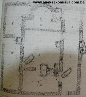
Basilica
The early Christian basilica stands some 100 metres from the edge of the slopes of Kamešnica, at an altitude of 706 m on the Kraljičin sandbank, at a crossroads on the Roman road linking the Livno polje with Salona and Narona. It lies east-west. The building materials used to erect the basilica were limestone, mudstone (sandstone), tufa and wood. The walls consist of courses as much as 25 cm high, with the gaps filled with small pieces of stone set in mortar. The stone from the foundation walls and, in particular, the walls of the basilica itself has been scattered about to such an extent that it was hard to determine how thick they were. The foundation walls of the apse were about 67 cm thick. The windows were glazed, as suggested by glass found in the soot in the nave and shards of glass scattered around the site.
Components of the basilica
The basilica was almost square in plan, at 15.90 x 17 m, with a central rectangular area consisting of the presbytery, nave (naos, navis), the portion reserved for the catechumens (narthex), and a baptistery or memorium (consignatorium) to the north and sacristy and porticus to the south.
The central area of the basilica is 8 m wide and 14.40 m long, with a horseshoe-shaped apse with a diameter of 2.60 m on the outside.
The sanctuary (A) occupies the apse and part of the central part of the basilica (1.45 x 6.70 m). All that survives of the apse walls are the foundations, which joined it structurally to the central area.
The nave (B), quadratum populi, is squarish, at 6.70 x 7.20 m. The south and north walls have survived in places to a height of 60 cm, and were plastered and painted white. The nave was entered through a door in the south wall close to the septum, which separated the nave from the sanctuary, of which the foundations met the north and south walls. The foundations of the altar partition have survived over their entire length to a height of 0 to 20 cm above the nave floor level (a stone base set in strong lime mortar with a top coat of rich mortar up to 3 cm thick).
The narthex (C), the portion reserved for the catechumens, measures 6.70 x 3.90 m, with a 2 m wide door between it and the nave. The south part of the wall separating it from the nave was damaged by mediaeval tombs. There was a door in the south wall too, leading from the narthex into area G, the porticus, where several tombs dating from early mediaeval times were also found. With one exception these tombs were above ground, and contained grave goods.
Side rooms to the north (15.60 x 3.55 m) and south (15.60 x 3m). The north side room, a narrow rectangle in plan except alongside the apse, lies alongside the central part of the basilica, and consists of two premises, D, the baptistery, and E, the consignatorium. Room D was probably a baptistery, but one should not rule out the possibility that it was a memorium, which could be ascertained if full excavations were to be carried out.(14) It was entered from the north through a door between it and room E; it had no direct access to the central part of the basilica. The walls have survived to a height of 60 to 80 cm. Only one grave has been found and excavated. Room E is smaller, to allow for the position of the apse. Only the foundations of the walls have survived, making it impossible to determine whether there was a door between this room and the central part of the basilica.
The south side room is somewhat narrower, also forming a narrow rectangle alongside the central part of the basilica. It too is divided into two: F, probably the sacristy, and G, the porticus, which is the most badly damaged (the eastern part of the wall has not survived and part of the south wall has been destroyed), lying alongside the nave and narthex. An opening, the main entrance to the basilica, was identified at the west end of the porticus, by the south wall of the narthex. A door led from the porticus into the narthex, with another at the end of the porticus by the partition wall of the nave. The walls are damaged, surviving in parts to a height of 80 cm. The remains of pottery vessels and daub, excavated below the level of the south foundation wall, below the room, indicate the presence of an earlier cultural stratum.
According to Đ. Basler, all the basilicas in Bosnia and Herzegovina have certain features in common, which he regards as typical, calling them the „Bosnian“ type: they are small, almost square in plan, and with only a small area for the congregation. According to N. Cambi, these features are not specific to Bosnia and Herzegovina, but are common throughout the Province of Dalmatia. The structural remains of the basilica and fragments of its stone furnishings indicate that it belongs to the religious buildings of the Salonitan-Naronitan area and hinterland dating from the 4th to the 6th century. This type evolved in Narona, and similar buildings can be seen in Dalmatia (Otok near Sinj, Dikovač near Imotski, Vrana near Zadar).(15)
Necropolis
A number of necropolises ranging in date from prehistoric to late mediaeval have survived at and in the environs of Rešetarica: there are a number of stećak tombstones to the south of St Elijah's church to the left of the main Livno-Split road, two graves lying north-west/south-east and surrounded by rubble stone have been identified north of this church on the very edge of the polje below the old road, and there is the necropolis on the Kraljičin (Queen's) sandbank. All that was visible of this necropolis was the area on which there were 19 stećak tombstones. This part of the site was investigated by archaeologist N. Miletić.
The southern part of the necropolis is about fifty metres to the east of the remains of the early Christian basilica, at a crossroads on the old Roman road one branch of which led to Podgradina and on to Lipa, and the other along the Kraljičin sandbank to Miši, Vidoši and Livno.(16)
The part of the necropolis at the base of the Kraljičin sandbank contains ordinary graves, oval and shape and of varying sizes; tombs partly clad with stone laid alongside the body of the deceased; and tombs with amorphously-shaped stone slabs of various sizes and thicknesses.(17)
The central part of the necropolis on the Kraljičin sandbank is located on and beside the remains of the early Christian basilica; some of the graves on the actual basilica site are here dealt with.(18) Seven graves have been identified within the ruins of the basilica, five of which are ordinary graves in the sand, and two of which were made of a single line of undressed stone laid around the deceased.(19)
All kinds of graves are represented in this central area of the necropolis, from ordinary graves to those built of stone and with stećak tombstones over them. Part of this necropolis has been excavated and studied(20),(21) but the greater part has been damaged or destroyed by the waters of the reservoir, as evidenced by various iron articles and by the grave goods collected around the site of the basilica.
Description of the graves within the remains of the 5th to 6th century basilica
Grave no. 1 is an ordinary grave in the ruins of the basilica, on the floor of the nave beside the south wall, lying west-east. It has not been excavated.
Grave no. 2 is an ordinary grave in the ruins of the basilica, beside the south wall of room D and partly in the opening between rooms D and E, lying west-east. It has not been excavated.
Grave no. 3 is an ordinary grave in the sand, on the outside by the south wall of room G, with the feet of the deceased on the wall itself. The grave is about ten centimetres above the level of the floor in the nave of the basilica. The deceased was laid on his back, his face turned to the east and arms by his sides, lying west-east. The grave goods consisted of a pair of lightweight spurs, a knife, and an iron bar the purpose of which is not known.
Grave no. 4 is an ordinary grave in the sand in room F, by the foundation wall of the apse. The deceased was laid on his back, his face turned to the east, his right arm at his side and the left bent at the elbow by the sword worn by the deceased, who was lying west-east. The grave goods consisted of the sword, a pair of spurs in pieces, a razor, a knife, a tinder box, two tangs from a set of buckles, and a few small pieces of iron of indeterminate shape.
Grave no. 5 is an ordinary grave in the sand by the south wall of the central part of the basilica, intersecting the partition wall between the nave and the narthex. The position of the grave indicates that when it was dug the basilica was not only in ruins but buried under soil and rubble, so that those who dug the grave did not even know the position or shape of the basilica. The deceased was laid on his back, his face turned to the east and arms by his sides. The grave is in the soot about ten centimetres below the nave floor. It has not been investigated, and has been covered over again.
Grave no. 6 is surrounded by a single course of sizeable pieces of rubble, probably spolia from the basilica, laid alongside the body of the deceased. The grave is in room G with the head by the north wall beside the entrance to the narthex, about 80 cm above the nave floor, level with the surviving stones of the ruins of the basilica. Lying north-west/south-east, it has not been excavated.
Grave no. 7 is an ordinary grave in the ruins of the basilica, surrounded by small undressed stones alongside the body of the deceased. It is in room B, with the top of the grave close to the north wall of the nave in the angle this forms with the partition wall between the nave and the narthex. It is 80 cm above the nave floor and lies north-west/south-east. It is damaged and has not been excavated.
The method of burial, the shape of the graves and their contents indicate that the necropolis on the Kraljičin sandbank belongs to the group of early mediaeval necropolises.
The most important find, without doubt, is the sword found in grave 4. In shape it is identical to the Carolingian type of sword, with a double-edged blade, short crossguard on the hilt, and flattened end (the K type of sword). By analogy, it most closely resembles the sword from Orlići near Knin and the one from Mogorjelo.(22) An X-ray of the sword revealed no marks. It could be said that the sword, like the other finds from the same grave, was made to the design of a Carolingian sword by a swordsmith in Dalmatia, in the late 8th or first half of the 9th century (Z. Vinski is of the view that by the 9th century, local swordsmiths were already influenced by the Carolingians.(23) The pair of very large spurs from the same grave are of the large Carolingian type of spur similar to those made to the Carolingian design from the 8th to the 10th century, probably in a Dalmatian workshop like the sword. By analogy, they most closely resemble the spurs from Gornji Koljani near Vrlika, Sinj Municipality. The spurs from grave no. 3 are also of the Carolingian type, lightweight and simple, most closely resembling the spurs from Crkvina near Knin. The razor among the grave goods in grave no. 4 belongs to the group of razors found in old Croatian necropolises in Dalmatian Croatia, with the tip of the blade curving backwards. It was used purely for everyday purposes. The knives from graves no. 3 and 4, like the knives found on the surface of the ruined graves, belong typologically to the group of short knives with sheaths dating from the 8th and 9th century. The two tinder-boxes (flint-and-steel) found in grave no. 4, with broken shanks, were items of everyday use in the 8th and 9th centuries. The iron artefacts found around the site of the basilica, from the demolished graves, consisted of various kinds of buckles, an iron clasp, a fragment of a rivet from a clasp, various kinds of bars, and an awl. Also among the grave goods in the basilica was a pottery vessel containing small snails.
A Roman coin, too badly worn to make out the inscription, was found in the sand two metres from the north-west corner of the basilica, level with the foundations. Its recognizable features suggest the Roman emperors Constantius II (353-361), Valentinian I (364-375) and Gratian (375-383). It is certainly a 4th century centenional (nominal) with on the obverse DN.... and a bust of the emperor in profile, with a diadem, and on the reverse a Roman legionnaire stepping out to the right, with a banner in his left hand and his right hand dragging by the hair a kneeling barbarian. The mint below this is illegible.
Numerous archaeological artefacts were found in the immediate area of and close to the remains of the basilica, as well as in the wider area of Rešetarica:
- quartz and bone artifacts;
- monuments dating from antiquity (fragment of a stone stele);
- stone fragments (the pilasters of an altar partition, pilasters with parts of a hemisphere, pilasters from the doors and windows of the basilica, columns from the altar partition, structural elements – fragments of imposts and capitals);
- metalwork artefacts (sword, spurs, bars, spikes, nails, a razor, knives, tinder-boxes [flint and steel], buckles);
- pottery (fragments of pottery vessels, bowls, jugs ranging in date from prehistoric through the classical age and early mediaeval to late mediaeval times);
- glass (window panes, fragments of jugs and cups, beads).
The Kraljičin (Queen's) sandbank site
A small necropolis is located on the flattened spine of the sandbank. Its 19 stećak tombstones are arranged in irregular, broken rows along the sandbank. In shape they are slabs and partly sunken chest-shaped stones, much weathered, with just one chest-shaped stone prominent on account of its size. The traces of what could be an epitaph on one of the tombstones are too faint to decipher. The tombstones lie in different directions, mainly north-west/south-east. In addition to this group, there are another three slab-shaped stećak tombstones at the very base of the sandbank, and a smaller necropolis with eight slab-shaped tombstones, six in a straight line, in the arable field known as Pod Docem (T. I,1. 2; annex 3).
Trial digs were carried out between 4 and 10 June 1969 at the two ends of the necropolis, covering the area by the graves with stećak tombstones, a total area of 80 m², using a 4 x 4 m quadrant system running east-west (quadrants I, II, III at the northern end, and IV and V at the southern end of the necropolis). Fourteen graves were discovered, two of which were double and one containing several skeletons – it proved impossible to ascertain exactly how many. About 20 skeletons were studied in all.
In the soundings at the northern end (quadrants I, II, III), the graves were dug in a solid layer of irregular rubble stone. A wall of undressed stone laid in regular courses, about 1.00 m high, was found in part of this area, forming a right-angle running south-west/north-east (Annex 3, T III, 2, behind grave no. 3). A biconical Bronze Age pottery vessel was found by this wall at a depth of 1.84 m, while many large and small shards of coarse pottery were found at various depths over the entire area, some decorated, dating from the prehistoric and mediaeval periods(24).
Description of the graves in the mediaeval necropolis
Grave no. 1: depth 0.89 m, length 1.76 m, orientation south-west/north-east. The relatively well-preserved skeleton of an adult, arms crossed over the chest. An irregularly-shaped slab had been placed above the head and at the feet, the headstone upright, the footstone laid flat. Grave goods: fragments of an iron needle on the chest, by the fingers of the right hand.
Grave no. 2: depth 0.39 m, length 1.04 m, orientation north-west/south-east. Relatively well preserved skeleton of a child. No grave goods.
Grave no. 3: grave under stećak no.13, chest-shaped and decorated along the middle with a rope-twist (size 1.29 x 1.30 x 0.48 m). The grave, consisting of a slab at each end and two slabs on each side, all of hewn stone, covered by a stone slab, was found below the stećak tombstone at a depth of 0.29 m. Orientation north-west/south-east. The grave contained several skeletons, their bones scattered and damaged. No grave goods.
Grave no. 4 (double)
4a: length 1.25m, orientation north-east/south-west. The damaged, dislocated skeleton of an adult. No grave goods.
4b: length 1.70 m, orientation north-east/south-west. Relatively well preserved skeleton, the leg bones somewhat displaced. No grave goods.
Grave no. 5 (quadrant. III, 1): depth 0.30 m. Minute remains of a child's skeleton. No grave goods.
Grave no. 6 (quadrant V, 4; double): depth of grave 0.59 m, orientation north-west/south-east.
6a: length 1.57 m. Partly dislocated skeleton of an adult with the remains of some oxidized matter in the mouth. No grave goods.
6b: length 1.54 m. Wholly scattered and damaged skeleton of an adult. No grave goods.
Grave no. 7 (quadrant V, 3): depth of surround 0.65 m, depth of grave 0.90 m, orientation south-west/north-east. The grave, constructed from small unevenly-shaped hewn stone slabs, contained a badly deteriorated child's skeleton. Grave goods: a fragmented iron needle by the right clavicle.
Grave no. 8 (quadrant V, 2): depth of surround 0.50 m, depth of grave 0.80 m, length 0.50 m, orientation north-west/south-east. The grave, constructed from small unevenly-shaped hewn stone slabs, contained a poorly preserved child's skeleton. No grave goods.
Grave no. 9 (quadrant V, 1): depth 0.65 m, length 1.78 m, orientation west-east. A surround of wooden planks, the remains of which could be seen to the sides, by the feet and above the skeleton, contained the poorly preserved skeleton of an adult. No grave goods.
Grave no. 10 (quadrant V, 5): depth 0.90 m, length 0.40 m, orientation north-west/south-east. Only the upper part of the skeleton was found, with the head in profile facing right. No grave goods.
Grave no. 11 (quadrant V, 6): depth of surround 0.64 m, orientation south-west/north-east. Part only of a tomb constructed of small, unevenly-shaped hewn stone slabs was found.
Grave no. 12 (quadrant IV, 2). Depth of tomb 0.46 m, depth of grave 0.82 m, length 0.51 m, orientation north-west/south-east. A poorly preserved child's skeleton was found. No grave goods.
Grave no. 13 (quadrant IV, 1): depth of tomb 0.33 m, depth of grave 0.71 m, length 0. 54 m, orientation north-west/south-east. A poorly preserved child's skeleton was found in a surround composed of small unevenly-shaped slabs. No grave goods.
Grave no. 14 (quadrant IV, 3): depth of tomb 0.40-0.50 m, depth of grave 0.74 m, length 1.71 m, orientation north-west/south-east. The tomb, constructed of large and small unevenly-shaped stones, contained the well-preserved skeleton of an adult, head facing forward and arms by the sides. Grave goods; four small spherical bronze buttons, by the right clavicle.
The graves in this necropolis were dug according to a certain system of forming rows, which is best seen in the south soundings (quadrant IV, V), though the stone structure in the northern part meant that the orderly arrangement was disrupted. This no doubt also resulted in the varied orientation of the graves in this part, whereas those at the southern end are all oriented the same way. Taken as a whole, the main orientation is north-west/south-east (9), followed by south-west/north-east (4), with just one lying east-west. Most of the graves had protective surrounds, usually of unevenly-shaped hewn stone slabs or stones laid around and above the skeleton. Only the grave below the stećak tombstone was of large, evenly-laid hewn stone slabs to the sides and evenly-shaped covering slabs (grave 3 under stećak no. 13), which was a common grave of the type discovered in the necropolis of stećak tombstones in nearby Grborezi near Livno, some of which were dated by coins to the 14th and 15th century(25). Only one grave contained wooden planks to the sides and over the skeleton. The position of the surviving skeletons was the usual one, on their backs, except for the child's skeleton no. 12, where the legs were bent at the knee. The position of the arms varied, some at the sides, others crossed on the chest or at the waist. Only three graves contained grave goods: two iron needles and some bronze buttons. These features, combined with a comparison with nearby necropolises (the sites of Mašeta and Glavica) and others from the wider area, are sufficient to associate the necropolis on the Kraljičin sandbank with the circle of socially and economically prominent communities of the 14th to 15th century.(26)
3. Legal status to date
At the time the decision to designate was being drafted, no details on previous protection were available from the Institute for the Protection of Monuments of the Federal Ministry of Culture and Sport.
4. Research and conservation and restoration works
Between 4 and 19 June 1969, protective archaeological investigations were conducted on the sites at the Kraljičin sandbank, led by archaeologist N. Miletić, according to whom the finds from the graves excavated were deposited at the National Museum of BiH in Sarajevo.
In the spring of 1989, the Sarajevo-based Institute for the Protection of Monuments and Natural Rarities in BiH began excavations and investigations on the basilica. More than ten tombs were discovered and opened in the nave and narthex, some of which contained grave goods.
5. Current condition of the property
During an on-site inspection conducted on 15 August 2007 the following was ascertained:
There are the scattered remains of masonry on the site where the basilica formerly stood, making it difficult to trace the outlines of the building. Comparing photographs taken during earlier archaeological investigations and the current condition of the site, it would seem that very little of the foundations of the basilica remain, as a result of the frequently-changing water levels in the reservoir (flooding of the site and shrinkage of the reservoir during the summer months).
6. Specific risks
Presence of the reservoir
III – CONCLUSION
Applying the Criteria for the adoption of a decision on proclaiming an item of property a national monument (Official Gazette of BiH nos. 33/02 and 15/03), the Commission has enacted the Decision cited above.
The Decision was based on the following criteria:
A. Time frame
B. Historical value
C. Artistic and aesthetic value
C.iv. composition
C.v. value of details
D. Clarity (documentary, scientific and educational value)
D.ii. evidence of historical change
D.iv. evidence of a particular type, style or regional manner
E. Symbolic value
E.i. ontological value
E.ii. religious value
G. Authenticity
G.i. form and design
G.v. location and setting
H. Rarity and representativity
H.i. unique or rare example of a certain type or style
The following documents form an integral part of this Decision:
- Copy of cadastral plan;
- Photodocumentation;
- Drawings.
Bibliography
During the procedure to designate the monument as a national monument of Bosnia and Herzegovina the following works were consulted:
1982. Miletić, Nada. “Izvještaj o iskopavanjima srednjevjekovnih nekropola u Buškom blatu” (Report on Excavations of the Mediaeval Necropolis in Buško blato) Jnl. of the National Museum (A) NS, 37. Sarajevo: 1982.
1988/1990. Vrdoljak, Fr Bono. “Starokršćanska bazilika i ranosrednjovjekovna nekropola na Rešetarici kod Livna” (The Early Christian Basilica and Early Mediaeval Necropolis at Rešetarica nr. Livno), Starohrvatska prosvjeta, ser. III, vol. 18. Split: 1988/1990.
1988. Arheološki leksikon BiH (Archaeological Lexicon of BiH), vol. 3, p. 244, no. 22.167. Sarajevo: 1988.
1994. Marijan, Boško. Jedan zanimljiv skup arheoloških nalazišta u Livanjskom polju (An interesting group of archaeological sites in the Livno polje). Split-Livno: 1994.
1994. Zaninović, Marijan. Livanjsko polje u antici kao primjer delmatske zajednice (The Livno polje in ancient times as an example of a Delmatae community). Split-Livno: 1994.
1999. Milošević, Ante. Arheološka zbirka Franjevačkog muzeja u Livnu (The archaeological collection of the Franciscan Museum in Livno), Foreword. Split: 1999.
1999. Petrinec, Maja. Srednjovjekovno razdoblje (The mediaeval period). Split: 1999.
(1) Kraljičin nasip, known locally as Prisap, which extended from the slopes of Kamešnica deep into Buško blato, was a sandbank rising as much as ten metres or so above the flatlands of Buško blato, between Livno and Tomislavgrad, which has been turned into a reservoir for the Orlovac hydro power plant
(2) A letter of 12 January 2009 from the Land Registry Office of the Municipal Court in Livno notified us that plots c.p. 1704/1, 1706/1, 1710/1 and 1711/1 have been abolished and merged with c.p. 1159/2 (the Podgradina dam, area 23145 sq.m.) on the A list II of electronic Land Register entry no. 264, c.m. Podhum-Vržerale.
(3) Ante Milošević, Arheološka zbirka Franjevačkog muzeja u Livnu, foreword, Split: 1999, 7
(4) Boško Marijan, Jedan zanimljiv skup arheoloških nalazišta u Livanjskom polju, Split-Livno: 1994, 32
(5) M Marijan Zaninović, Livanjsko polje u antici kao primjer delmatske zajednice, Split-Livno: 1994, 46
(6) B. Marijan, op. cit., 42
(7) Nada Miletić, “Izvještaj o iskopavanjima srednjevjekovnih nekropola u Buškom blatu,” Jnl of the National Museum (A) ns., 37, Sarajevo: 1982, 144
(8) Cremation of the deceased
(9) Burial
(10) M. Zaninović, op.cit., 1994, 47
(11) Maja Petrinec, Srednjovjekovno razdoblje, Split, 1999, 30
(12) M. Petrinec, op.cit., 1999, 32
(13) The historic site of the old fort in Livno, the Bistrica fort was designated as a national monument at the Commission's 15th session, held from 6 to 10 July 2004.
(14) Fr Bono Vrdoljak, “Starokršćanska bazilika i ranosrednjovjekovna nekropola na Rešetarici kod Livna” in Starohrvatska prosvjeta, ser. III., vol. 18, Split: 1988./1990, 236
(15) Fr. Bono Vrdoljak, op.cit., 1988/1990, 183
(16) Fr. Bono Vrdoljak, op.cit., 1988/1990, 243
(17) The quarry from which the stone was extracted to build the basilica and make tombstones is clearly recognizable above the base of the Kraljičin sandbank
(18) The petition submitted pertains only to this part of the necropolis, which has been investigated
(19) The archaeological investigations were conducted in the spring of 1989 by the Institute for the Protection of Monuments and Natural Rarities in BiH, and revealed that the necropolis had more than ten above-ground tombs in the nave and narthex, some with grave goods. During the recent war the finds from the site were lost ?
(20) Nada Miletić, op.cit., 1982, 123,165
(21) The 19 stećak tombstones investigated form part of the Decision
(22) Fr. Bono Vrdoljak, op.cit. 1988/1990, 247
(23) Fr. Bono Vrdoljak, op.cit. 1988/1990, 37
(24) N. Miletić, op.cit., 1989, 125
(25) N. Miletić, op.cit., 1989, 127
(26) N. Miletić, op.cit., 1989, 146
|