Status of monument -> National monument
Published in the “Official Gazette of BiH” no. 60/08.
Pursuant to Article V para. 4 Annex 8 of the General Framework Agreement for Peace in Bosnia and Herzegovina and Article 39 para. 1 of the Rules of Procedure of the Commission to Preserve National Monuments, at a session held from 11 to 17 September 2007 the Commission adopted a
D E C I S I O N
I
The historic site of the prehistoric hillfort and the mediaeval and Ottoman fort of Sokolac in the village of Sokolac, Bihać Municipality, is hereby designated as a National Monument of Bosnia and Herzegovina (hereinafter: the National Monument).
The National Monument consists of fortifications dating from the late mediaeval and Ottoman periods, and movable archaeological material housed in the National Museum of Bosnia and Herzegovina in Sarajevo, listed in the Museum's inventory.
The National Monument is located on a site designated as cadastral plot no. 427 (old survey), corresponding to c.p. no. 464 (new survey), Land Register entry no. 685, cadastral municipality Sokolac, in the village of Sokolac, Bihać Municipality, Federation of Bosnia and Herzegovina, Bosnia and Herzegovina.
The provisions relating to protection measures set forth by the Law on the Implementation of the Decisions of the Commission to Preserve National Monuments, established pursuant to Annex 8 of the General Framework Agreement for Peace in Bosnia and Herzegovina (Official Gazette of the Federation of BiH nos. 2/02, 27/02, 6/04 and 51/07) shall apply to the National Monument.
II
The Government of the Federation of Bosnia and Herzegovina (hereinafter: the Government of the Federation) shall be responsible for ensuring and providing the legal, scientific, technical, administrative and financial measures necessary for the protection, conservation and presentation of the National Monument.
The Commission to Preserve National Monuments (hereinafter: the Commission) shall determine the technical requirements and secure the funds for preparing and setting up signboards with basic details of the monument and the Decision to proclaim the property a National Monument.
III
To ensure the on-going protection of the National Monument on the site defined in Clause 1 para. 3 of this Decision, the following measures are hereby stipulated:
- research and conservation and restoration works, routine maintenance works, and works designed to display the monument shall be permitted, subject to the approval of the Federal Ministry responsible for regional planning (hereinafter: the relevant ministry) and under the expert supervision of the heritage protection authority of the Federation of Bosnia and Herzegovina (hereinafter: the heritage protection authority),
- the site of the National Monument shall be open and accessible to the public, and may be used for educational and cultural purposes,
- planning and implementing the use of the monument shall be carried out in association with the heritage protection authority,
- works on the infrastructure are prohibited unless with the approval of the relevant ministry and the expert opinion of the heritage protection authority,
- the construction of full-profile roads, houses or any buildings or facilities the construction or operation of which could endanger the National Monument or its setting is prohibited,
- the dumping of waste is prohibited.
IV
The removal of the archaeological material referred to in Clause 1 para. 2 of this Decision (hereinafter: the movable heritage) from Bosnia and Herzegovina is prohibited.
By way of exception to the provisions of paragraph 1 of this Clause, the temporary removal from Bosnia and Herzegovina of the movable heritage for the purposes of display or conservation shall be permitted if it is established that conservation works cannot be carried out in Bosnia and Herzegovina.
Permission for temporary removal under the conditions stipulated in the preceding paragraph shall be issued by the Commission to Preserve National Monuments, if it is determined beyond doubt that it will not jeopardize the movable heritage in any way.
In granting permission for the temporary removal of the movable heritage from Bosnia and Herzegovina, the Commission shall stipulate all the conditions under which the removal may take place, the date by which the items shall be returned to the country, and the responsibility of individual authorities and institutions for ensuring that these conditions are met, and shall notify the Government of the Federation of Bosnia and Herzegovina, the relevant security service, the customs authority of Bosnia and Herzegovina, and the general public accordingly.
V
All executive and area development planning acts not in accordance with the provisions of this Decision are hereby revoked.
VI
Everyone, and in particular the competent authorities of the Federation of Bosnia and Herzegovina, the Canton, and urban and municipal authorities, shall refrain from any action that might damage the National Monument or jeopardize the preservation and rehabilitation thereof.
VII
The Government of the Federation, the relevant ministry, the Federal ministry responsible for culture, the heritage protection authority, and the Municipal Authorities in charge of urban planning and land registry affairs, shall be notified of this Decision in order to carry out the measures stipulated in Articles II to VI of this Decision, and the Authorized Municipal Court shall be notified for the purposes of registration in the Land Register.
VIII
The elucidation and accompanying documentation form an integral part of this Decision, which may be viewed by interested parties on the premises or by accessing the website of the Commission (http://www.aneks8komisija.com.ba)
IX
On the date of adoption of this Decision, the National Monument shall be deleted from the Provisional List of National Monuments of Bosnia and Herzegovina (Official Gazette of BiH no. 33/02, Official Gazette of Republika Srpska no. 79/02, Official Gazette of the Federation of BiH no. 59/02, and Official Gazette of Brčko District BiH no. 4/03), where it featured under serial no. 60.
X
Pursuant to Art. V para 4 Annex 8 of the General Framework Agreement for Peace in Bosnia and Herzegovina, decisions of the Commission are final.
XI
This Decision shall enter into force on the date of its adoption and shall be published in the Official Gazette of BiH.
This Decision has been adopted by the following members of the Commission: Zeynep Ahunbay, Amra Hadžimuhamedović, Dubravko Lovrenović, Ljiljana Ševo and Tina Wik.
No: 05.2-2-62/07-4
12 September 2007
Sarajevo
Chair of the Commission
Dubravko Lovrenović
E l u c i d a t i o n
I – INTRODUCTION
Pursuant to Article 2, paragraph 1 of the Law on the Implementation of the Decisions of the Commission to Preserve National Monuments, established pursuant to Annex 8 of the General Framework Agreement for Peace in Bosnia and Herzegovina, a “National Monument” is an item of public property proclaimed by the Commission to Preserve National Monuments to be a National Monument pursuant to Articles V and VI of Annex 8 of the General Framework Agreement for Peace in Bosnia and Herzegovina and property entered on the Provisional List of National Monuments of Bosnia and Herzegovina (Official Gazette of BiH no. 33/02) until the Commission reaches a final decision on its status, as to which there is no time limit and regardless of whether a petition for the property in question has been submitted or not.
The Commission to Preserve National Monuments issued a Decision to add the Prehistoric hillfort and mediaeval and Ottoman fort of Sokolac in Sokolac to the Provisional List of National Monuments of Bosnia and Herzegovina, numbered as 60.
Pursuant to the provisions of the law, the Commission proceeded to carry out the procedure for reaching a final decision to designate the Property as a National Monument, pursuant to Article V para. 4 of Annex 8 and Article 35 of the Rules of Procedure of the Commission to Preserve National Monuments.
II – PROCEDURE PRIOR TO DECISION
In the procedure preceding the adoption of a final decision to proclaim the property a national monument, the following documentation was inspected:
- Documentation on the location and current owner and user of the property (copy of cadastral plan and copy of land register entry)
- Historical, architectural and other documentary material on the property, as set out in the bibliography forming part of this Decision.
The findings based on the review of the above documentation and the condition of the property are as follows:
1. Details of the property
Location
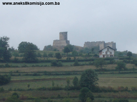
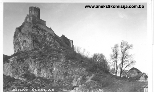
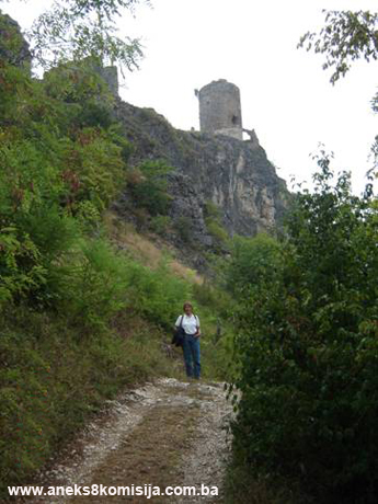
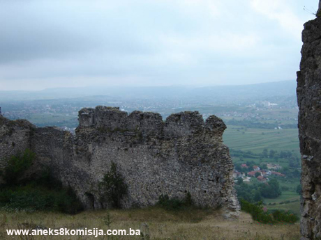
The old Sokolac fort is on a spur to the east of Debeljače hill on the left bank of the Una river. Below it is the Golubić plain, the river Una and the main road. The village of Sokolac can be reached from Bihać by taking the roads along the left bank of the Una or from Golubić, where there is a road bridge over the river from the main road along the right bank of the Una. The second crossing over a good bridge from the main road is somewhat to the south, in Lohovo. The fort is on a precipitious limestone cliff about 60 m above the last house in the village of Sokolac. The road begins to climb from level ground through the main mahala with the village centre, mosque and old burial ground. At the top of the village, by the last house, is a plateau from which an easy walk along a good path takes one to the fort about 60 m above the plateau at the top of the village.
The National Monument is located on a site designated as cadastral plot no. 427 (old survey), corresponding to c.p. no. 464 (new survey), Land Register entry no. 685, cadastral municipality Sokolac, in the village of Sokolac, Bihać Municipality, Federation of Bosnia and Herzegovina, Bosnia and Herzegovina.
Historical information
The fort in Sokolac is referred to in mediaeval documents as Sokol. It is marked on a map by M Quad printed in Amsterdam in 1593 as Zokol, and the same name is used in all mediaeval documents until Sokol and Bihać came under Ottoman rule. A 1699 map features it under the name Sokolatz.
The oldest charter referring to Sokolac dates from 1395, naming it as a royal town with castellans Ivan, known as Uza, and Grgur Eten (Lopašić, 1943, 217). The fort is close to Bihać, with which it has a shared history. In the struggle between King Sigismund of Luxembourg and Ladislav (Louis) of Naples for the royal throne and the Bosnian crown, battles were also waged to seize power in the towns and forts of the Bihać frontier region. During the summer, Bihać fell to Sigismund, and Sokol fort was probably also in November that year; according to a document dated 16 April 1404 it was in his possession (Lovrenović, 2006, 103, 127). During a battle sometime between 1403 and 1404 nearby Bihać was lost to the supporters of King Louis and Herceg Hrvoje, falling into the hands of supporters of Sigismund, who took Bihać in 1405. He alternated between Bihać and Sokol between 28 September and 8 October, but by 18 October that year Bihać was already back in the hands of Sigismund’s opponent Hrvoje Vukčić (Lovrenović, 2006, 127, 128).
During Sigismund’s campaign against the Bosnians, which ended with the battle of Dobor in the late summer of 1408, some of Sigismund’s troops made for north-western Bosnia. The Bihać fort was held by King Louis’s and Herceg Hrvoje’s troops, while the commander of Sokolac fort Sigismund’s loyal follower Tomo, son of Tumpa of Kutina. During Sigismund’s 1408 campaign which ended with the battle of Dobor, there was also fighting in the upper Una near Bihać. With the help of the Ottomans, the troops fighting against Sigismund attacked the Ripač and Sokolac forts, but there too they were trounced by Tomo Tompa (Lopašić, 1943, 217, Lovrenović, 2006, 127).
Under the terms of charters of 1431 and 1434, the royal town of Sokol with its lands, together with Bihać, was bestowed by King Sigismund on his followers, the Krk-Frankopan princes, ban (governor) Nikola and Stjepan. In 1449, under the division of the estate between the sons of ban Nikola, Sokol and Bihać belonged to prince Bartol Frankopan. In 1490 Sokol came into the hands of Croatia’s ban Ivaniš Corvin, who received both the title and the lands after the death of his father, Matthias Corvin. After the death of ban Ivaniš in 1505, the Sokol and Bihać forts against came under royal rule. In 1510 King Louis allocated the Sokol fort to the aristocratic Orlovići’s of Ripač and Čavka. Grgur, one of the Orlović brothers, became captain of Senj, which also defending the region by the Una from the Ottomans in this part of the world. In 1529, three years after the death of Grgur Orlović (who was killed at Mohács in 1526), King Ferdinand granted Sokol and its kotar (district) to Petar Kružić, who restored it to the widow and children of Grgur Orlović. In 1534 the widow Matra Orlović ceded estates to her son-in-law, the aristocrat Ladislav Kerečen, including the Sokol fort. It is not known how Sokol rapidly came into the hands of the Zagorje aristocrat Juraj Vragović.
Since the Sokol fort was important for the defence of Bihać, in 1538 King Ferdinand ordered the Bihać captain, Petar Keglević, to do all he could to acquire the fort from its authorized overlords. At that time the fort was reinforced. The Krajiška (frontier) administration held Sokol under lease from August 1549. Under the terms of an agreeement of 1550, King Ferdinand leased the Sokol fort from the Kerečen family. After this, a military guard was installed in Sokol, under the command of the Bihać captain.
In 1537, a powerful Ottoman army succeeded in capturing part of the fort, as far as the main tower, which held out. Another major Ottoman assault in the area, and on the fort, was launched in August 1561 under the command of two of Malkoč-beg’s sons. They torched everything from Previlica in the north to Ripač in the south. Some of the local people found shelter inside the ramparts of the Sokol fort, but many were taken into slavery or were displaced. In 1586, Sarvaš pasha attached Golubić and laid it waste. Prior to this, the Golubić plain had been a fertile valley providing quantities of food for the garrison attached to the Sokol fort. By 1578 the Ottomans were again trying to capture the fort, but without success; they again failed in 1591 under the leadership of the Livno beg. With the fall of Bihać in 1592, the Sokol fort also came under Ottoman rule (Lopašić, 1943, 216-221). Little is known of the Sokol fort during the Ottoman period.
As the lands in the Una valley were gradually taken by the Ottomans in the second half of the 16th century, ending with the fall of Bihać in 1592, the forts along the right bank of the Una, from Krupa to the north, were joined to the Bosnian sandžak. When Bihać was taken in 1592 and the Ottomans began restoring order, they founded the Bihać sandžak. Although the oldest reliable reference to this sandžak is in a document dating from 1620, it was probably founded some time beetween the fall of Bihać in 1592 and 1620. The second reference to the Bihać sandžak is in a Veneto-Dalmatian description of the Bosnian pashaluk in 1624-1626 (Šabanović, 1982, 82-84). The major towns of the sandžak were Bihać, Kamengrad, Ripač, Cazin, Bužim, Ostrožac and Krupa. The headquarters were in Bihać or, at times, in Krupa. It seems that the Bihać sandžak was abolished in the mid 17th century. It was reestablished at the end of the same century. In the 18th century the Bihać sandžak was one of five in the Bosnian pashaluk, but in 1711 it was finally and conclusively abolished. It was divided into kadiluks (Šabanović, 1982, 85, 230). The Bihać kadiluk was probably founded just after the fall of Bihać in 1592, though the earliest reference to it is in 1619. This kadiluk contained the towns of gradovi Bihać, Izačić, Sokol, Ripač, and others. In the 17th century there is one reference to Krupa and Ripač as separate kadiluks (Šabanović, 1982, 181, 228, 230). During the entire Ottoman period, nearby Ripač was a more important fort, located on an island in the Una to the south of Sokol fort. According to an inventory carried out in 1833, the fortress in Sokolac (in the Bihać kadiluk), contained only two small cannon, while an undated inventory reveals that there were only twelve soldiers in the fort (Kreševljaković, 1952, 146, 124).
2. Description of the property
Prehistoric hillfort
The hillfort was recorded by Radimsky during his tour of prehistoric sites in the Bihać area while working on the large necropolis in Jezerine (1891-1893). The fort covered the entire upper plateau of the Debeljače spur, including the part where the Sokolac fort was later built. It measured 670 m x 170 m at its widest point, and lay south-east/north-west. The highest point of the slope is the rocky outcrop on which the mediaeval fort was built, on the south-east side of the Debeljače spur. The hillfort slopes more gently to the north-west, and does not stand on the precipitious crags as does the fort. Here Radimsky discovered the remains of the dry walls surrounding the hillfort. He also observed a rocky earthwork outside the former fosse of the fort, in the vacant south-eastern area. He came upon large quantities of prehistoric pottery opposite the earthwork, on the northern edge of the slope bordering the cliffs. An urn belonging to a prehistoric necropolis with level graves was found under a slab. Large quantities of pottery vessels belonging to the same period as the finds from the lake dwellings in Ripač were also found on the plateau outside the north-western wall of the fosse. Major finds included a pottery mould for casting small bronze articles and the much damaged remains of bronze jewellery. The pottery dates this to the late Bronze Age, 10th-9th century BCE. Iron artifacts were found on the same site – knives and horseshoes of uncertain age (V. Radimsky 1893, 45-47).
Fortifications dating from the mediaeval and Ottoman periods
In ground plan the Sokolac fort forms a triangle with its highest point at the south-eastern corner, where the main tower was built. Like the entire slope, it slopes from the south-east to the north-west. The fort is 175 m long and 120 m wide at its widest point, by the north-west wall.
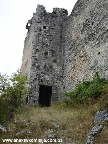
The fort has two towers: the gatehouse to the north, and the main tower or keep at the south-east high point of the plateau. The towers are linked by a spacious bailey. The ramparts and towers are built partly of hard stone and partly of tufa, which was abundant here.
The gatehouse was built against the north rampart, facing the Golubić plain and the river Una. The gatehouse measures 3 x 4 m. One door leads into the gatehouse, with another door in the opposite wall leading into the bailey. This made it possible to close the gatehouse off for defensive purposes. It is about 15 m in height, and has three storeys. Since the walls are high and it is impossible to fire down them through loopholes, machicolations were built at the top of the gatehouse along all three walls to prevent anyone from reaching the door by stealth. The machicolations are in fact projecting walls on three sides. They have no floor, but gaps through which the enemy could be targeted. The frontal wall provided the defenders with protection. The narrower walls, to the sides, are supported by stone brackets. The fourth wall is also the bailey rampart.
The bailey of the fort is quite large. The longest rampart is the northern, where the entrance to the fort was located, opposite the keep. A length of 38 m of this rampart has survived, with only the traces at ground-level of another 14 m. This rampart joins the wall of the small bailey surrounding the keep. Only 15 m of the south wall opposite has survived, too; the rest has disappeared, as evidently have parts of both these ramparts in the eastern part of the fort, near the keep. The western bailey rampart has survived almost in its entirety. It is about 40 m long and had a fosse outside it, which is now full of soil and dense vegetation. At the top of the bailey ramparts, the remains of close-set breastworks can be seen, each with a small central loophole. The breastworks are about 0.6 m apart. Below them are the remains of consoles or sockets for the structure of the wooden walkway. Inside the spacious fort Radimsky saw signs of the remains of houses abutting onto the ramparts and on the rather worn stone and grassy ground in the lower part near the gatehouse. All that can now be seen is hewn stone as part of the footings of the houses.
The keep stands on the highest rocky point of the spur of the hill. It is surrounded on all four sides by a small inner bailey which is an irregular rectangle in shape. There are two entrances to this bailey. One in the west wall of the small bailey of the keep, which is at a height of 3 m and needed a ladder for access, is the entrance from the main bailey. The other entrance is in the south-east (rear) wall of this bailey, in a rather inaccessible place. Nowadays the way into the bailey is through a large gap in the wall. Traces of the steps alongside the inner wall face, that were used to climb up to the wooden walkways below the loopholes at the top of the wall, can be seen by this entrance. Truhelka writes that this small bailey was roofed over and contained a cistern (Truhelka, 1904, 31). There is now no sign of this cistern.
The keep was 10 m in diameter and about 16 m high, with walls 2.4 m thick. The entrance to the keep was at first-floor level. On either side of the entrance to the keep are doors leading to steep steps inside the wall, one up to the second and third floor and one down to the ground floor. The first floor contains a room with a Gothic vault, with a diameter of 5.2 m. There are the remains of brackets at the base of the slope of the vault on each wall, probably used to hold shelves. The walls also had a number of recesses, used for storage. This room is lit by two large windows. Since they are in walls almost 2.5 m thick, the windows are so deeply set into the wall that the side walls up to the windows have benches along the entire length. Truhelka found a fireplace in one of these window spaces, which was also there in 1953 during conservation works, but is no longer in existence. There were similar rooms on the second and third floors. The windows of the keep are rectangular. The keep was also topped by a machicolation and a row of loopholes, and the whole thing topped by a pointed wooden roof. General Lenković described the keep thus: "A strong round tower with three vaults and surrounded by a wall. The vanished roof should be replaced, with two gutters, the breastworks and loopholes should be repaired, and the walls around it, over which in times past the Turks climbed, being unable to conquer the tower, should be raised and a jetty for the guard should be constructed on them."
Steps led down from the first floor to the cramped ground floor, with a small room and much thicker walls than the upper storeys.
3. Legal status to date
The ruins of the old fort in Sokolac are registered as a cultural monument, but were not placed under state protection.
The Regional Plan of Bosnia and Herzegovina to 2000, Stage B, Natural and Culturo-Historical Values, compiled in 1980, listed the old fort in Sokolac as a Category II monument.
The property is on the Provisional List of National Monuments of the Commission to Preserve National Monuments as no. 60 under the heading Bihać – prehistoric hillfort and mediaeval and Ottoman fort of Sokolac in Sokolac.
On 20 July 2006 the Bihać Municipal Council issued a permit for research works and the preparation of project documentation with a view to raising funds to restore the old forts of Sokolac and Ostrovica.
4. Research and conservation and restoration works
In 1893 the property was visited by Vaclav Radimsky, who provided a brief description of it and of the prehistoric finds. In the bailey he found the visible remains of buildings, some of which had stood alongside the ramparts. The keep and the ramparts around it were in a good state of preservation (Radimsky, 1983, 45-46).
In 1898 Grof (Count) Lothar von Bercks, Bihać district prefect at that time, restored parts of the fort.
In 1953 repair works on the old Sokolac fort near Bihać were carried out by experts from the Republic Institute for the Protection of Cultural Monuments of BiH in Sarajevo and the Pounje (Una Valley) Regional museum.
5. Current condition of the property
During an on-site inspection on 10 August 2007 it was found that the layout of the fortress is well preserved by that parts of the south and north ramparts have been totally destroyed. The stone from the top and revetments of the ramparts is falling away, and there are large gaps in the walls in places. The breastworks topping the surviving ramparts are gradually crumbling away. The fosse outside the fort is no longer recognizable.
6. Specific risks to which the property is exposed
- Climatic factors;
- Inadequate maintenance, reflected in the overgrowth on and around the walls and the stone falling from parts of the revetments of the ramparts;
- Vandalism by visitors writing graffiti on the walls;
- Extraction of stone from the walls.
III – CONCLUSION
Applying the Criteria for the adoption of a decision on proclaiming an item of property a national monument (Official Gazette of BiH nos. 33/02 and 15/03), the Commission has enacted the Decision cited above.
The Decision was based on the following criteria:
A. Time frame
B. Historical value
C. Artistic and aesthetic value
C.iii. proportions
C.iv. composition
C.v. value of details
C.vi. value of construction
D. Clarity (documentary, scientific and educational value)
D.i. material evidence of a lesser known historical era
D.ii. evidence of historical change
D.iv. evidence of a particular type, style or regional manner
F. Townscape/ Landscape value
F.ii. meaning in the townscape
G. Authenticity
G.i. form and design
G.v. location and setting
I. Completeness
I.ii. homogeneity
The following documents form an integral part of this Decision:
- Copy of cadastral plan;
- Copy of land register entry and proof of title;
- Photodocumentation – photographs taken by the Commission on 9 August 2007;
- Photographs from reference works;
- Two maps;
- Documentation of the Institute for the Protection of Monuments of Una-Sana Canton.
Bibliography
During the procedure to designate the monument as a national monument of Bosnia and Herzegovina the following works were consulted:
1893. Radimský, Vaclav, “Nekropola u Jezerinama u Pritoci kod Bišća” (The Necropolis in Jezerine in Pritoka near Bišće), Jnl. of the National Museum in Sarajevo, V, Sarajevo, National Museum, 1893, 37-92.
1904. Truhelka, Ćiro, Naši gradovi, opis najljepših sredovječnih gradova Bosne i Hercegovine (Our Towns, Description of the Most Beautiful Old Towns of Bosnia and Herzegovina), Sarajevo, Naklada Knjižare J. Studnička and others, 1904.
1943. Lopašić, Radoslav, Bihać i Bihaćka krajina (Bihać and the Bihać Frontier Region) (2nd ed.), Zagreb, 1943.
1952. Kreševljaković, Hamdija, Prilozi povijesti bosanskih gradova pod turskom upravom. Prilozi za orijentalnu filologiju i istoriju jugoslovenskih naroda pod turskom vladavinom (Contributions to the History of Bosnian Towns under Turkish Administration, Contributions for Oriental Philology and the History of the South Slavs under Turkish Governance), II/1951, Institute for Oriental Studies in Sarajevo, Sarajevo, 1952, 119-184.
1953. Kreševljaković, Hamdija, “Stari bosanski gradovi” (Old Bosnian Forts), Naše starine I, Sarajevo, 1953, 7-45.
1957. Vego, Marko, Naselja srednjovjekovne bosanske države (Settlements of the mediaeval Bosnian state), Svjetlost, Sarajevo, 1957.
1972. “Pregled konzervatorsko-restauratorskih radova u proteklih dvadesetpet godina” (Overview of Conservation and Restoration Works during the past 25 Years), Naše starine XIII, Sarajevo, 1972, 30-36.
1982. Šabanović, Hazim, Bosanski pašaluk, postanak i upravna podjela (Bosnian Pashaluk, origins and administrative division), Svjetlost, Sarajevo, 1982
1995. Kruhek, Milan, Krajiške utvrde i obrana hrvatskog kraljevstva tijekom 16. stoljeća (Frontier Fortresses and the Defence of the Kingdom of Croatia in the 16th Century), Zagreb, 1995.
2006. Lovrenović, Dubravko, Na klizištu povijesti (sveta kruna ugarska i sveta kruna bosanska) 1387-1463 (On the Landslide of History [The Holy Hungarian Crown and the Holy Bosnian Crown] 1387-1463), Zagreb-Sarajevo, 2006.
|