Published
in the “Official Gazette of BiH”, no. 13/10.
Pursuant
to Article V para. 4 Annex 8 of the General Framework Agreement for Peace in Bosnia and Herzegovina
and Article 39 para. 1 of the Rules of Procedure of the Commission to Preserve
National Monuments, at a session held from 11 to 17 September 2007 the
Commission adopted a
D E C I S
I O N
I
The
historic site of the necropolis with stećak tombstones at Mramorje in the
village of Hrid in Međurječje, Municipality Čajniče is
hereby designated as a National Monument of Bosnia and Herzegovina
(hereinafter: the National Monument).
The
National Monument is located on a site designated as cadastral plot nos.
2806/1, 2806/2, 2806/3 and 2806/4 (old survey), Land Register entry no. 465,
cadastral municipality Batovo, Municipality Čajniče, Republika Srpska, Bosnia
and Herzegovina.
The
provisions relating to protection measures set forth by the Law on the
Implementation of the Decisions of the Commission to Preserve National
Monuments, established pursuant to Annex 8 of the General Framework Agreement
for Peace in Bosnia and
Herzegovina (Official Gazette of Republika
Srpska no. 9/02 and 70/06) shall apply to the National Monument.
II
The
Government of Republika Srpska shall be responsible for providing the legal,
scientific, technical, administrative and financial measures necessary for the
investigation, protection, conservation and presentation of the National
Monument.
The
Commission to Preserve National Monuments (hereinafter: the Commission) shall
determine the technical requirements and secure the funds for preparing and
setting up signboards with basic details of the monument and the Decision to
proclaim the property a National Monument.
III
To ensure
the on-going protection of the National Monument on the area defined in Clause
1 para. 2 of this Decision, the following protection measures are hereby
stipulated:
-
all works are prohibited
other than archaeological investigation works and conservation works, including
those designed to display the monument, with the approval of the ministry
responsible for regional planning in Republika Srpska (hereinafter: the
relevant ministry) and under the expert supervision of the heritage protection
authority of Republika Srpska (hereinafter: the heritage protection authority);
-
the construction of new
buildings is prohibited, as is the erection of temporary facilities or
permanent structures not designed solely for the protection and presentation of
the monument;
-
construction or other
works that could have the effect of altering the site or its surroundings are
prohibited;
-
infrastructure works are
permitted solely subject to the approval of the relevant ministry and the
expert opinion of the heritage protection authority;
-
the dumping of waste is
prohibited;
-
the site of the monument
shall be open and accessible to the public and may be used for educational and
cultural purposes.
The
following works shall be carried out in order to implement urgent protection
measures on the National Monument:
-
clearing the site of weeds
and self-sown vegetation;
-
making good the southern
edge of the necropolis by the road at the crossroads where tombs can be seen;
-
improving the access to
the necropolis;
-
drawing up a programme for
the presentation of the National Monument
IV
All
executive and area development planning acts are hereby revoked to the extent
that they are not in accordance with the provisions of this Decision.
V
Everyone,
and in particular the competent authorities of Republika Srpska and urban and
municipal authorities, shall refrain from any action that might damage the
National Monument or jeopardize the preservation thereof.
VI
The
Government of Republika Srpska, the relevant ministry and the heritage
protection authority, and the Municipal authorities in charge of urban planning
and land registry affairs, shall be notified of this Decision in order to carry
out the measures stipulated in Articles II – V of this Decision, and the
authorized Municipal Court shall be notified for the purposes of registration
in the Land Register.
VII
The
elucidation and accompanying documentation form an integral part of this Decision,
which may be viewed by interested parties on the premises or by accessing the
website of the Commission (http://www.aneks8komisija.com.ba)
VIII
Pursuant
to Art. V para 4 Annex 8 of the General Framework Agreement for Peace in Bosnia and Herzegovina,
decisions of the Commission are final.
IX
This
Decision shall enter into force on the day following its publication in the
Official Gazette of BiH.
This
Decision has been adopted by the following members of the Commission: Zeynep
Ahunbay, Amra Hadžimuhamedović, Dubravko Lovrenović, Ljiljana Ševo and Tina
Wik.
No: 05.2-2-253/05-5
12 September 2007
Sarajevo
Chair of
the Commission
Dubravko
Lovrenović
E l u c i
d a t i o n
I – INTRODUCTION
Pursuant
to Article 2, paragraph 1 of the Law on the Implementation of the Decisions of
the Commission to Preserve National Monuments, established pursuant to Annex 8
of the General Framework Agreement for Peace in Bosnia and Herzegovina, a
“National Monument” is an item of public property proclaimed by the Commission
to Preserve National Monuments to be a National Monument pursuant to Articles V
and VI of Annex 8 of the General Framework Agreement
for Peace in Bosnia and Herzegovina and property entered on the Provisional
List of National Monuments of Bosnia and Herzegovina (Official Gazette of BiH
no. 33/02) until the Commission reaches a final decision on its status, as to
which there is no time limit and regardless of whether a petition for the
property in question has been submitted or not.
On 26
September 2005 the Sinan-pasha Sijerčić Society for the Preservation of the
Natural and Civilizational Heritage of Goražde submitted a petition/proposal to
designate the Mramorje necropolis with stećak tombstones in Hrid, Međurječje,
Municipality Čajniče as a national monument.
Pursuant
to the provisions of the law, the Commission proceeded to carry out the
procedure for reaching a final decision to designate the Property as a National
Monument, pursuant to Article V of Annex 8 and Article 35 of the Rules of
Procedure of the Commission to Preserve National Monuments.
II – PRELIMINARY PROCEDURE
In the
procedure preceding the adoption of a final decision to proclaim the property a
national monument, the following documentation was inspected:
-
Documentation on the
location and current owner and user of the property (copy of cadastral plan and
copy of land registry entry).
-
Data on the current
condition and use of the property, including a description and photographs,
data of war damage, data on restoration or other works on the property, etc.
-
Historical, architectural
and other documentary material on the property, as set out in the bibliography
forming part of this Decision.
The
findings based on the review of the above documentation and the condition of
the site are as follows:
1. Details of the property
Location
The
necropolis with stećak tombstones at Mramorje is in Hrid, by the bridge over
the river Janjina, on the road in the western part of the village of Međurječje
and environs. Works on the road carried out during the 1992-1995 war at the
intersection of the Čajniče-Međurječje and Batovo-Ustiprača roads caused
considerable damage to the necropolis. The best access to Međurječje is via the
road from Čajniče, some 15 km away.
The
National Monument is located on a site designated as cadastral plot nos.
2806/1, 2806/2, 2806/3 and 2806/4 (old survey), Land Register entry no. 465,
cadastral municipality Batovo, Municipality Čajniče, Republika Srpska, Bosnia
and Herzegovina.
Historical information
In late
mediaeval times this region belonged to the Upper Drina valley, which was on
the borders of the Serbian state until 1377, when it became part of Bosnia as the result of the divisions of the
lands of Nikola Altomanović between King Tvrtko I of Bosnia
and Serbia's
Prince Lazar. As the land-owning Kosača family gained in strength in the late
14th and 15th centuries the area came under the rule of Sandalj Hranić and
Herceg Stjepan Vukčić Kosača. A number of Dubrovnik
archive documents of that time contain numerous records of trade, artisanal and
transit activities in Foča, Goražde and Ustikolina. Richly forested and with
fertile valleys, the area was well suited to the development of animal
husbandry, apiculture, grain crops and other agricultural produce.
The
mediaeval history of the settlement in Međurječje is associated with the
Samobor fort, some 4-5 km from Međurječje. The only good road suitable for
conveying goods and people on horseback to Samobor was from Međurječje in the
south. On 13 October 1461, Herceg Stjepan issued a charter in nearby
Međurječje. This is the only reference to the settlement prior to the final
Ottoman conquest of this region in the latter half of 1466.
Samobor
was also one of the principal strongholds of Herceg Stjepan Vukčić Kosača,
inherited from his uncle Sandalj Hranić in 1435. Documents dating from the
first half of the 15th century refer to it mainly in reference to envoys from Dubrovnik staying with
Sandalj Hranić. A document dating from 13 January 1423 containing the itinerary
of a Dubrovnik legation also refers to Sottosamobor, the outskirts of
the Samobor fort, where the Dubrovnik emissaries met Sandalj(1). Samobor is referred to again in
similar contexts on 19 January 1428, 1430 and 1435(2). However, the fort and its
outskirts were seldom the destination of trade caravans: prior to 1435, only
three caravans whose destination was Samobor are recorded in historical sources(3).
Samobor
is more frequently mentioned during the rule of Herceg Stjepan, but these
documents are associated with Ottoman advances in 1465. In the late spring of
1465 the Ottoman army, led by the Bosnian sanjak bey, Isa-beg Ishaković,
advanced into the lands of Herceg Stjepan. The first of the Herceg’s forts in
the Upper Drina valley to fall into their
hands was Samobor(4). Even
during the last years of the Herceg's rule in the Upper Drina the outskirts of
Samobor did not develop into a significant trade centre, and it was very rare
for its inhabitants to incur debts in Dubrovnik, and only then for small sums(5). The exact location of the
settlement on the outskirts of Samobor has not yet been identified, but it was
presumably Međurječje. Later, along with Čajniče, Međurječje was of
considerable importance for this region, right up to the 1992-1995 war.
Although
there are only few or no references to places in this part of the world in
mediaeval sources, the numerous necropolises with stećak tombstones, local
tradition, and the earliest Ottoman sources provide evidence that it was
inhabited east and south of Goražde and Ustiprača as far as Čajniče(6).
The area
was occupied during the Ottoman offensive that began in the summer of 1465 in
the Herceg's lands. First to fall were the eastern parts of his lands,
including the forts of Mileševac and Samobor(7).
Between
then and 1832, when the fort was abandoned, the Ottomans maintained a permanent
garrison there under the command of a dizdar. Given Samobor's importance for
the wider region, when nahijas (administrative district) were established, it
became the centre of the nahija of Pribud or Samobor(8). Čajniče and Samobor were
recorded along with other nahijas and places in the area: Pljevlja, Foča,
Goražde, Bistrica with Ustikolina, Osanica and so on, in the defter (official
records) of 1468/69 in the nahija of Samobor, in the Hercek Vilajet in the Bosnian
sanjak. The nahija of Samobor or Pribud is referred to by its double name until
the 18th century.
The
nahija of Samobor or Pribud belonged to the Drina
kadiluk, and in 1572 there is reference to Čajniče as a kasaba (small town) in
the Foča kadiluk. In 1582, Čajniče became an independent kadiluk, to which the
nahijas of Pribud and Samobor (formerly a single nahija), Dubštica (with its
centre in Rudo) and Međurječje all belonged(9). A mosque was built in Međurječje in the second half of the 18th
century.
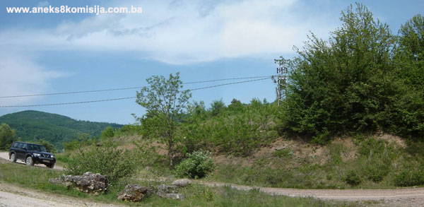
2. Description of the property
The
remains of the necropolis at Mramorje in Hrid in Međurječje now lie on both
sides of the road, which was widened at this point and a crossroads made since
the 1992-1995 war. The entire necropolis appears to have been on an elevation
to the north of the road, while a number of stećak tombstones, of which three
can now be identified, ended up on the opposite site of the road in a meadow by
the little river Janjina. There is a considerable difference in height between
the area to the north of the road and that to the south. The road runs along
the Janjina valley, which naturally widens towards the south beside the
necropolis, at the crossroads.
The
necropolis extended along an elevation north of the road over an area of about
100 m west-east (along part of the road from Čajniče to the crossroads for
Ustiprača and Batovo) and about 60 m north-south. Reference works state that
100 stećak tombstones were identified in the necropolis, 98 of them
chest-shaped and two ridge-shaped (gabled)(10). The Report on the protective investigative works in 1998 states
that there are 62 stećak tombstones in the necropolis, 19 slab-shaped, 27
chest-shaped and 16 gabled. The tombstones are of average workmanship, and were
already in a poor state of preservation even when Bešlagić studied them, with
many chipped, overturned or shifted out of position(11). They lie west-east. The site is
now so overgrown that about 15 stećak tombstones can be seen in a small area. All
lie west-east and are arranged in rows running from north to south. It is hard
to describe them since only part of the gable can be seen of the occasional
gabled tombstone, and only the flat surface of the chest-shaped tombstones. The
average measured size of these stećak tombstones is 1 m long x 0.6 m wide.
When the
road was widened the southern part of the necropolis was cut off. Stećak
tombstones can be seen on the surface of the profile, while in the lower parts
of the profile the slabs that formed covers can be clearly seen, often in two
rows. The necropolis to the north of the road is on higher ground on which the
profile indicates several strata of burials. During the 1998 investigations two
test trenches were excavated (6 x 3 m and 5 x 1 m) with a total area of 23 m2,
in the damaged area in the southern part of the necropolis. Twenty-seven
skeletons were discovered. The deceased were buried in simple earth graves, the
depth and bottom of which could not be ascertained because the site had been
too badly disturbed. All the graves dated from late mediaeval times. Since the
burials were quite closely packed here, the researchers assumed that this was
the main area of the necropolis. Judging from the condition of the finds and
the few finds of typical late mediaeval pottery, the necropolis dates roughly from
the late 14th to the 15th century. Judging from the number of stećak tombstones
previously recorded (about 100), it was the necropolis of a rural community.
During
excavation of the graves, prehistoric pottery was found, suggesting a
prehistoric settlement or burial ground on this high ground above the river
Janjina.
3. Legal status to date
The
Regional Plan for BiH to 2000, stage B – valorization, includes all the listed
necropolises of Čajniče
Municipality as a group,
under category III.
4. Research and conservation and
restoration works
Protective
and investigative archaeological works on the Mramorje necropolis were carried
out from 20 September to 15 October 1998 headed by archaeologist Milka
Radoja with a team from the Museum
of Republika Srpska (the
Report, with 20 attachments, is in the Commission’s documentation and has been
transferred to digital form).
5. Current condition of the
property
The
necropolis is completely overgrown with grass and trees. To the north of the
road only 15 or so stećak tombstones can be seen, overgrown with trees at the
edge of the trees, to the south of the road, in the meadow by the Janjina, are
three tombstones sunk into the ground. The entire site gives the impression of
being neglected.
6. Specific risks
-
lack of maintenance
-
impact of natural factors
III – CONCLUSION
Applying
the Criteria for the adoption of a decision on proclaiming an item of property
a national monument (Official Gazette of BiH nos. 33/02 and 15/03), the
Commission has enacted the Decision cited above.
The
Decision was based on the following criteria:
A. Time frame
B. Historical value
C. Artistic and aesthetic value
D. Clarity
(documentary, scientific and educational value)
D.i. material evidence of a lesser known
historical era
E. Symbolic value
E.v. significance for the identity of a group of
people
G. Authenticity
G.v. location and setting
The
following documents form an integral part of this Decision:
-
Copy of cadastral plan
-
Copy of land register
entry
-
Photodocumentation (77 photographs
taken on site on 16 May 2007)
-
“Report on Protective
Archaeological Investigations Conducted at Mramorje in Međurječje, Municipality
Čajniče” compiled by Milka Radoja, architect from the Museum of Republika Srpska
(3 pp. text, excerpt from cadastre and 19 drawings of graves and soundings)
Bibliography
During
the procedure to designate the monument as a national monument of Bosnia
and Herzegovina the following works were
consulted:
1892. Delić, Stevan. “Samobor kod Drine” (Samobor on the Drina), Jnl. of the National Museum in Bosnia and
Herzegovina 1892, no. IV, 255-269.
1951. Jireček, Josip. Trgovački drumovi i rudnici Srbije i Bosne u
srednjem vijeku (Trade Routes and Mines of Serbia and Bosnia in Mediaeval Times). Sarajevo: Svjetlost,
1951.
1957. Vego, Marko. Naselja srednjovjekovne bosanske države
(Settlements of the Mediaeval Bosnian state). Sarajevo: Svjetlost, 1957.
1971. Bešlagić, Šefik. Stećci, kataloško-topografski pregled
(Stećak tombstones, a catalogue and topographical survey). Sarajevo: Veselin Masleša, 1971, 142-143.
1973. Petrović, Đurđica. “Arhivsko-istorijska istraživanja,” In:
Various authors: Gornje Podrinje u doba Kosača (The Upper Drina Valley
in the Time of the Kosačas), research programme no. III/1973. headed by
Institute for the Protection of Cultural Monuments of Bosnia and Herzegovina, Sarajevo. Sarajevo: 1973, 38-85.
1978. Dinić, Mihailo. “Zemlje hercega Sv. Save” (Lands of Herceg St.
Sava) In: Srpske zemlje u srednjem veku (Serbian lands in the mediaeval
period). Belgrade:
1978, 178-269.
1978. Kovačević-Kojić, Desanka. Gradska naselja srednjovjekovne
bosanske države (Urban Settlements of the Mediaeval Bosnian
State). Sarajevo: 1978.
1981. Kojić-Kovačević Desanka. “Arhivsko-istorijska istraživanja
gornjeg Podrinja” (Archival and Historical Research into the Upper Drina Valley) In: Drina
u doba Kosača (The Drina in the Time of the Kosačas), Naše starine
XIV-XV. Sarajevo:
1981, 109-125.
1982. Šabanović, Hazim. Bosanski pašaluk (The Bosnian Pashaluk).
Sarajevo: 1982.
(1) Jireček, Josip,
Trgovački drumovi i rudnici Srbije i Bosne u srednjem vijeku, Sarajevo: Svjetlost, 1951,
63.
(2) Jireček,
Josip, Ibidem, 1951, 63, 67; Kojić-Kovačević Desanka, Gradska naselja
srednjovjekovne bosanske države, Sarajevo:
1978, 101, n. 106
(3)
Kojić-Kovačević Desanka, Ibidem, 1978, 101; Kojić-Kovačević Desanka, “Arhivsko-istorijska
istraživanja gornjeg Podrinja”, In: Drina u doba Kosača, Sarajevo: Naše starine
XIV-XV, 1981, 117-118.
(4) Dinić, Mihailo,
“Zemlje hercega sv. Save”, in: Srpske zemlje u srednjem veku, Belgrade: 1978, 260.; Šabanović, Hazim, Bosanski
pašaluk, Sarajevo: Svjetlost, 1982, 44.;
Vego, Marko, Naselja bosanske srednjovjekovne države, Sarajevo: Svjetlost, 1957, 103.
(5) Kojić-Kovačević
Desanka, Ibidem, 1978, 101, n.105 and 106, 243, n. 80.
(6) Petrović, Đurđica,
“Arhivsko-istorijska istraživanja” in various authors: Gornje Podrinje u
doba Kosača, naučnoistraživački program br. III/1973. Led by the Institute for the Protection of
Cultural Monuments of Bosnia and Herzegovina,
Sarajevo, Sarajevo:
1973, 38-42.
(7) Vego,
Marko, Ibidem, 1957, 28, 97.; Šabanović, Hazim, Ibidem, 1982, 44.
(8) Šabanović,
Hazim, Ibidem, 1982, 120.
(9) Šabanović,
Hazim, Ibidem, 1982, 117, 120, 136, 139, 195.
(10) Delić,
Stevan, “Samobor kod Drine”, Jnl of the National Museum in Bosnia and
Herzegovina, 1892, no. IV, 255.; Bešlagić, Šefik, Stećci,
kataloško-topografski pregled, Sarajevo:
1971, 269.
(11) Bešlagić,
Šefik, Ibidem, 269-270.