Status of monument -> National monument
Pursuant
to Article V para. 4 Annex 8 of the General Framework Agreement for Peace in Bosnia and Herzegovina
and Article 39 para. 1 of the Rules of Procedure of the Commission to Preserve
National Monuments, at a session held from 22 to 28 May 2007 the Commission
adopted a
D E C I S
I O N
I
The
historic site of the old military burial ground at Hrtar in Milatkovići,
Čajniče Municipality, is hereby designated as a National Monument of Bosnia and
Herzegovina (hereinafter: the National Monument).
The
National Monument consists of the remains of an old military burial ground
dating from the Ottoman period (one intact grave with nišan tombstones, two
overturned nišan tombstones, and a heap of tufa stone which had been
used as surrounds for the graves).
The
National Monument is located on a site designated as cadastral plot no. 3677
and 3678, title deed no. 479/4, cadastral municipality Milatkovići,
Municipality Čajniče, Republika Srpska,
Bosnia and Herzegovina.
The
provisions relating to protection measures set forth by the Law on the
Implementation of the Decisions of the Commission to Preserve National
Monuments, established pursuant to Annex 8 of the General Framework Agreement
for Peace in Bosnia and
Herzegovina (Official Gazette of Republika
Srpska no. 9/02 and 70/06) shall apply to the National Monument.
II
The
Government of Republika Srpska shall be responsible for ensuring and providing
the legal, scientific, technical, administrative and financial measures
necessary for the protection, conservation and presentation of the National
Monument.
The
Commission to Preserve National Monuments (hereinafter: the Commission) shall
determine the technical requirements and secure the funds for preparing and
setting up signboards with basic details of the monument and the Decision to
proclaim the property a National Monument.
III
With a
view to protecting the National Monument, protection measures are hereby
prescribed relating to part of the area defined in Clause 1 para. 3 of this
Decision: from a point on the forest track (Y=6595780, X=4828992) on c.p. no.
3678, from which it proceeds due north to the Drvaljica brook. The boundary
line of the protected zone continues upstream to the end of c.p. no. 3677 then
runs south along the forest margin, i.e. the boundary of c.p. 3677. From there
the boundary line continues to a point on the forest track (Y=6595673,
X=4828995) on c.p. no. 3678, then eastwards along the forest track to return to
the starting point, thereby enclosing the protected zone.
The
following protection measures are hereby prescribed for this area:
-
all works are prohibited
other than investigative and conservation-restoration works, routine
maintenance works, and works designed for the presentation of the monument,
with the approval of the ministry of Republika Srpska responsible for regional
planning (hereinafter: the relevant ministry) and under the expert supervision
of the heritage protection authority of Republika Srpska (hereinafter: the
heritage protection authority);
-
the site of the monument
shall be open and accessible to the public, and may be used for educational and
cultural purposes;
-
infrastructure works may
be carried out with the approval of the relevant ministry and under the expert
supervision of the heritage protection authority;
-
the refurbishment of the
burial ground and repairs to any damage are permitted solely subject to first
drawing up a plan for repairs, restoration and conservation and to the approval
of the relevant ministry, and under the expert supervision of the heritage
protection authority;
-
the removal of lichen and
moss from the stećaks is prohibited;
-
by way of exception to the
above provision, the stećaks may be cleaned if required to examine the
epigraphic or decorative features of a stećak, subject to first compiling a
report and obtaining the approval of the entity ministry responsible for
regional planning. The report should be based on such biological, chemical,
physical and other analyses as a conservator considers necessary, and should
include appropriate conservation measures and an assessment of the impact of
cleaning methods on the stone;
-
the area is an
archaeological site, and investigative works must therefore be carried out in
the presence of an archaeologist;
-
the dumping of waste is
prohibited.
The
Government of Republika Srpska shall be responsible in particular for ensuring
that the following measures are carried out:
-
conducting a geodetic
survey of the site;
-
drawing up a plan for the
repair, restoration, conservation and presentation of the National Monument.
The repair,
restoration and presentation plan shall include:
-
archaeological
investigations of the site of the National Monument;
-
tidying the burial ground
and removing self-sown vegetation;
-
the routine maintenance of
the monument.
IV
All
movable artefacts found during the course of the archaeological survey shall be
deposited in the nearest museum able to provide the necessary personnel,
material and technical conditions or in the National Museum of Bosnia and
Herzegovina in Sarajevo,
catalogued, and suitably presented.
All
movable and immovable archaeological material found during the course of the
archaeological investigations shall be professionally recorded.
Upon
completion of the archaeological works the archaeologist leading the
investigations shall submit a report to the Commission and to the institution
that conducted the investigations.
The
archaeologist leading the investigations must have access to all the movable
and immovable archaeological material found during the course of the
investigations and until his/her report is completed, for a period not
exceeding three years.
All
immovable finds shall be conserved in situ as the archaeological
investigations proceed, and the movable archaeological material shall be
conserved and placed for safe keeping in a suitable storage facility.
Upon
receipt of a report on the investigations conducted, the Commission shall
identify which movable artefacts shall be subject to protection measures to be
determined by the Commission.
The
removal of the movable artefacts found during the archaeological survey from Bosnia and Herzegovina
is prohibited.
V
All
executive and area development planning acts are hereby revoked to the extent
that they are not in accordance with the provisions of this Decision.
VI
Everyone,
and in particular the competent authorities of Republika Srpska and urban and
municipal authorities, shall refrain from any action that might damage the
National Monument or jeopardize the preservation and rehabilitation thereof.
VII
The
Government of Republika Srpska, the relevant ministry and the heritage
protection authority, and the Municipal Authorities in charge of urban planning
and land registry affairs, shall be notified of this Decision in order to carry
out the measures stipulated in Articles II – VI of this Decision, and the
Authorized Municipal Court shall be notified for the purposes of registration
in the Land Register.
VIII
The
elucidation and accompanying documentation form an integral part of this
Decision, which may be viewed by interested parties on the premises or by
accessing the website of the Commission (http://www.kons.gov.ba)
IX
Pursuant
to Art. V para 4 Annex 8 of the General Framework Agreement for Peace in Bosnia and Herzegovina,
decisions of the Commission are final.
X
This Decision
shall enter into force on the day following its publication in the Official
Gazette of BiH.
This
Decision has been adopted by the following members of the Commission: Zeynep
Ahunbay, Amra Hadžimuhamedović, Dubravko Lovrenović, Ljiljana Ševo and Tina
Wik.
No: 05.2-2-250/05-6
23 May 2007
Sarajevo
Chair of
the Commission
Dubravko
Lovrenović
E l u c i
d a t i o n
I – INTRODUCTION
Pursuant
to Article 2, paragraph 1 of the Law on the Implementation of the Decisions of
the Commission to Preserve National Monuments, established pursuant to Annex 8
of the General Framework Agreement for Peace in Bosnia and Herzegovina, a
“National Monument” is an item of public property proclaimed by the Commission
to Preserve National Monuments to be a National Monument pursuant to Articles V
and VI of Annex 8 of the General Framework Agreement for Peace in Bosnia and
Herzegovina and property entered on the Provisional List of National Monuments
of Bosnia and Herzegovina (Official Gazette of BiH no. 33/02) until the
Commission reaches a final decision on its status, as to which there is no time
limit and regardless of whether a petition for the property in question has
been submitted or not.
On 26
September 2005 the Sinan-paša Sijerčić Association for the Preservation of the
Natural and Civilizational Heritage, Goražde, submitted a petition/proposal to
the Commission to Preserve National Monuments to designate the old military
burial ground at Hrtar in the village
of Milatkovići, Čajniče Municipality,
as a national monument.
Pursuant
to the provisions of the law, the Commission proceeded to carry out the
procedure for reaching a final decision to designate the Property as a National
Monument, pursuant to Article V para. 4 of Annex 8 and Article 35 of the Rules
of Procedure of the Commission to Preserve National Monuments.
II – PRELIMINARY PROCEDURE
In the
procedure preceding the adoption of a final decision to proclaim the property a
national monument, the following documentation was inspected:
-
details of the current
condition and use of the property, including a description, architectural
survey and photographs
-
an inspection of the
current state of the property
-
a copy of the cadastral
plan
-
a copy of the Land
Register entry
-
historical, architectural
and other documentary material on the property, as set out in the bibliography
forming part of this Decision
Pursuant
to Article V para. 2 of Annex 8 of the General Framework Agreement for Peace in
Bosnia and Herzegovina and Article 37 of the Rules of Procedure of the
Commission, before rendering a final decision designating a property as a
national monument, the Commission is required to provide the owner of the
proposed monument, the person submitting the petition, the institutions
responsible for heritage, professional and academic institutions, experts and
scholars, as well as other interested parties, to express their views. On 26
September 2005 the Commission received a Petition with covering letter from the
Sinan-paša Sijerčić Association for the Preservation of the Natural and Civilizational
Heritage, Goražde.
Accordingly,
the Commission sent a letter ref. 05.2-35-250/05-2 of 15 February 2007
requesting documentation and views on the designation of the old military
burial ground at Hrtar in the village of Milatkovići, Čajniče Municipality, as
a national monument as a national monument of Bosnia and Herzegovina to Čajniče
Municipality (Mayor, cadastre department, Municipal Court), the Ministry of
Regional Planning, Construction and the Environment of Republika Srpska, the
Institute for the Protection of the Cultural and Natural Heritage of Republika
Srpska and the Institute for the Protection of Monuments under the Federal
Ministry of Culture and Sport, and the Sinan-paša Sijerčić Association for the
Preservation of the Natural and Civilizational Heritage, Goražde.
The
Commission subsequently sent a letter ref. 05.2-36.1-11/12-135 of 16 November
2012 to the Banja Luka Department of Geodetics and Proprietary Rights, Čajniče
branch, requesting cadastral plans from the Austro-Hungarian survey and title
deeds for c.p. nos. 3677 and 3678, c.m. Milatkovići, Čajniče.
In
response, the Commission has received the following documentation:
-
letter ref.
094-0-Rz-07-000 013 of 19 February 2007 from the Land Registry office of the
Municipal Court in Foča notifying the Commission that the Court does not
possess the Land Register, which was destroyed by fire during World War II;
-
letter ref.
07-40-4-565-1/07 of 22 February 2007 from the Institute for the Protection of
Monuments under the Federal Ministry of Culture and Sport notifying the
Commission to Preserve National Monuments that the Institute has no
documentation on the site of the old military burial ground at Hrtar in the
village of Milatkovići, Čajniče Municipality;
-
letter ref.
50-50-952-21/07 of 12 March 2007 from the Banja Luka Department of Geodetics
and Proprietary Rights, Čajniče branch, notifying the Commission that the
Čajniče branch has no details relating to the site in question, that the
establishment of the registry cadastre is in force, and that a qualified person
from the Commission and a qualified person from the Čajniče branch will need to
be present on site to identify the plots;
-
letter ref. 01-624-1/07 of
9 August 2007 from the Mayor of Čajniče notifying the Commission that details
such as the municipality, town or village, cadastral plots, cadastral
municipalities and excerpts from the cadastre may be obtained from the Čajniče
branch of the Banja Luka Department of Geodetics and Proprietary Rights;
-
letter ref.
21.50/952.2-123/12 of 22 November 2012 from the Banja Luka Department of
Geodetics and Proprietary Rights, Čajniče branch, supplying the Commission with
the cadastral details of the site in question.
The findings
based on the review of the above documentation and the condition of the
property are as follows:
1. Details of the property
Location
The old
military burial ground is in the forest about half an hour's walk to the west
[of the village of Milatkovići] at a place called Hrtar in the village of Milatkovići. The village is reached by
road from Čajniče via the village
of Zaborak, from which a
rough track, barely passable even in a four-wheel-drive vehicle, leads through
fields and forest to Milatkovići. The remains of the old military Muslim burial
ground are above the meadow called Rustovina in the place known as Hrtar, on
the edge of pine and beech forest. The site is about half an hour to the west
of the last house in the village and the burial ground where members of the
Božović family are buried.
The
National Monument is located on a site designated as cadastral plot no. 3677
and 3678, title deed no. 479/4, cadastral municipality Milatkovići,
Municipality Čajniče, Republika Srpska,
Bosnia and Herzegovina.
Čajniče Municipal Council is the owner of the plots.
Historical background
Nothing
is known of Čajniče in the time of the mediaeval Bosnian state. The entire area
is in the upper Drina valley, which was on the borders of the Serbian state until
1377, when Nikola Altomanović's lands were divided between Bosnia's King Tvrtko I and Serbia's Prince Lazar, and the district was
allotted to Bosnia.
When the Kosača landowning family gained strength in the late 14th and 15th
centuries, the region came under the rule of Sandalj Hranić and herceg Stjepan
Vukčić Kosača. Among the archive documents of Dubrovnik dating from that period, the most
numerous are those relating to trade, artisanal and transit activities in Foča,
Goražde and Ustikolina. This region, rich in forests and fertile valleys, was
ideal for the development of livestock herding, bee-keeping, and the production
of grain and other agricultural crops. Although there is no reference to
Čajniče itself in mediaeval sources, in the very abundant archive material of
that time relating to the upper Drina valley, the numerous necropolises with
stećak tombstones, local folktales, and the earliest Ottoman sources are
evidence that this region was well settled(1). Despite the absence of references to Čajniče in mediaeval
sources, it was already a market town when the Ottomans arrived in the region.(2)
Čajniče
was occupied during the Ottoman offensive which began in the summer of 1465 in
the Herceg's lands. First to fall to them were the eastern regions of the
Herceg's lands, including the forts of Mileševac and Samobor(3). Čajniče and Samobor were
listed, together with other nahijas and towns in the region (Pljevlja, Foča,
Goražde, Bistrica with Ustikolina, Osanica, etc.), in the defter [tax
census records] for 1468/69, in the nahija [smallest administrative unit
in the Ottoman Empire] of Samobor, in the
vilayet of Hercek in the Bosnian sandžak. The nahija of Samobor or Pribud was
referred to by its dual name until the 18th century. In that same census,
Čajniče is described as "the bazaar of Čajniče in the nahija of
Samobor," and was listed in the imperial has [crown lands, from Ar.
khas] with an iron mine, six forges, and 415 smelting furnaces. The 1477
census listed Čajniče in the imperial has with 190 households and 5 bachelor
households. The nahija belonged to the Drina
kadiluk, but in 1572 Čajniče was referred to as a kasaba [small town] in
the Foča kadiluk. In 1582 it became an independent kadiluk in its own right, to
which the nahijas of Pribud and Samobor (previously a single nahija) belonged,
along with Dubštica (with its centre in Rudo) and Međurječje.(4)
In
mediaeval times, the main road through this region was the Via Drinae, and Foča
and Goražde were its principal towns. In the Ottoman period, the road from Bosnia to Istanbul
ran through Čajniče. Judging from the 1573 account by the French traveller
Philippe Dufresne Canaye and Evliya Çelebi's 1664 account, Čajniče was a
wealthy town.(5)
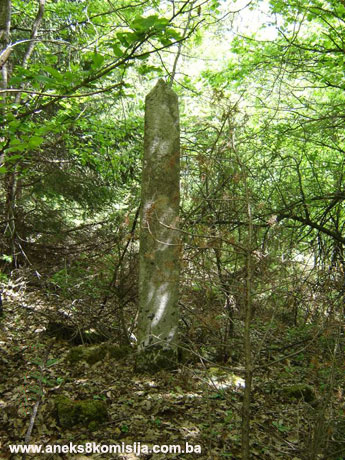
2. Description of the property
The
remains of the old military burial ground at Hrtar are on a gentle slope on the
southern edge of mixed beech and pine forest. It is about half an hour's walk
to the west of the houses in the village
of Milatkovići, along a
path that was once a footpath to Ustiprača. According to local residents, there
are the remains of some kind of building below the southern edge of the forest,
in the meadow known as Hrtar, close to the burial ground on a terraced site. An
inspection of the grassy area revealed no sign of these remains.
The
remains of the old military burial ground cover a small area of about 100 x 50
m, with the longer side following the lie of the land west-east. The entire
area is covered with fallen leaves and branches, with some plant growth. It is
full of stones, partly visible above ground and covered with moss. It is
impossible to say how many graves there were in the burial ground. As well as
three fallen nišan tombstones and a heap of cut tufa blocks, there is
one intact grave with its nišan tombstones still standing. This lies west-east
with a slight deviation to the north. In the large burial ground in Presjeka
near Ustikolina, all the old Muslim graves lie in the same direction as the one
surviving grave in Hrtar, not facing south-east as was the usual practice(6). The headstone, which is about
2.20 m high, is square in section, with a long neck topped by a turban and mudžereta(7). The footstone is in the shape
of a narrow upright slab terminating in a ridge, about 30 cm wide and 12 cm
thick. The grave is about 3 m long and is surrounded by cut tufa basal stones
of varying sizes, giving the impression of massive stone blocks. The base of
both nišan tombstones was covered in earth and moss, so that it was not
possible to ascertain how they were mounted on the grave; however, given the
remains of several tufa basal stones with holes to take the head and
footstones, suggesting that these two were probably mounted in the same way. There
were similar findings in the burial ground in Presjeka near Ustikolina(8).(9)
The
headstone nišan has carvings of a spear and banner on the south face, a curved
sabre on the north face. Both motifs are frequently to be found on the earliest
known nišan gravestones dating from the second half of the 15th and the 16th
century, but the nišans from that period are stouter, of cruder workmanship,
and usually end in the shape of a prism.
One
square-section headstone topped with a neck and turban is lying on the ground,
together with the plinth, to which it is still attached. It is similar in
workmanship to the headstone on the only surviving grave, but its condition
made it possible to determine whether it was decorated.
Parts of
yet another overturned nišan, this one polygonal in section and narrowing at
the top, are partly covered with earth and moss. These two fallen tombstones
probably also belonged to the same grave, but it would require excavations to
confirm this.
The nišan
gravestones are well cut from hard, mainly white stone, apart from the
footstone on the grave, which is grey. All the other scattered or piled-up
blocks were cut from tufa and were used as grave surrounds. They show no signs
of joining holes. Among them were a number of blocks with holes in the middle
into which the nišan gravestones would have been fitted.
There a
various other pieces of hard stone on the site of the burial ground, but it was
impossible to tell whether they belonged to some small, almost amorphous stećak
tombstones, so this question remains unresolved.
The
proposal/petition states that the burial ground in Milatkovići dates from
1415-1419, probably on the basis of some tradition. The burial ground in
Presjeka near Ustikolina is also associated in local tradition with the early
years of the Ottoman conquest of these parts(10). It is a known fact that large, decorated nišan gravestones of
the type found in Milatkovići, imposing in size and often elaborately
decorated, were erected to commemorate Muslim shahids [martyrs] who suffered a
hero’s death fighting for their faith. A similar nišan gravestone, albeit
rather more massive and elaborately decorated, was found in the Shahid's burial
ground in Presjeka, west of the burial ground already described there. Graves
more than three metres long, with surrounds like those in Milatkovići and the
burial ground in Presjeka, were found in the Shahid's burial ground.(11)
The nišan
with a turban in Milatkovići has all the features of a shahid's grave, both in
size, material and workmanship and in the choice of decorative motifs (the
spear and banner and the sabre), as well as in the size of the grave itself. Judging
from parallels in the wider region, the burial ground in Milatkovići could date
from the late 15th or the 16th century. The nišan gravestone that most closely
resembles this one is in the old Muslim burial ground at Varoš in the hamlet of
Popovići near Kalinovik.(12)
3. Legal status to date
No prior
statutory protection.
4. Research and conservation and
restoration works
None
5. Current condition of the
property
The site
is derelict, the stone is covered with moss, and the surviving nišan tombstones
have fallen and are lying on the ground. One grave is intact, and its surround
can be made out below the leaves.
6. Specific risks
Natural
factors will lead to further deterioration.
III – CONCLUSION
Applying
the Criteria for the adoption of a decision on proclaiming an item of property
a national monument (Official Gazette of BiH nos. 33/02 and 15/03), the
Commission has enacted the Decision cited above.
The
Decision was based on the following criteria:
A. Time frame
B. Historical value
C. Artistic and aesthetic value
C.i. quality of workmanship
C.ii. quality of materials
C.iii. proportions
C.v. value of details
D. Clarity
(documentary, scientific and educational value)
D.i. material evidence of a lesser known
historical era
E. Symbolic value
E.v. significance for the identity of a group of
people
H. Rarity and representativity
H.i. unique or rare example of a certain type
or style
The
following documents form an integral part of this Decision:
-
Ownership documentation(13)
-
letter ref.
21.50/952.2-123/12 of 22 November 2012 from the Banja Luka Department of
Geodetics and Proprietary Rights, Čajniče branch, supplying the Commission with
the cadastral details of the site in question.
-
Documentation on previous
protection of the property
-
letter ref.
07-40-4-565-1/07 of 22 February 2007 from the Institute for the Protection of
Monuments under the Federal Ministry of Culture and Sport notifying the
Commission to Preserve National Monuments that the Institute has no
documentation on the site of the old military burial ground at Hrtar in the
village of Milatkovići, Čajniče Municipality.
-
Photodocumentation
-
photographs of the
property taken on 9 May 2007 and 4 October 2012 by archaeologist Lidija Fekeža
and historian Zijad Halilović using Canon EOS 450D digital camera.
-
Technical documentation
-
technical survey of the
property (survey of the monument) conducted on 9 May 2007 by Lidija Fekeža. The
protected zone was surveyed on 4 October 2012 by Zijad Halilović, archaeology
specialist, and Ešref Salihagić, surveyor and freelance associate.
Bibliography
During the
procedure to designate the monument as a national monument of Bosnia
and Herzegovina the following works were
consulted:
1940. Dinić, Mihailo. Tri francuska putopisca XVI veka u našim
zemljama (Three 16th century French travel chroniclers in our lands). Belgrade: Anniversary of
Nikola Čupić, bk. XLIX, 1940, 85-118. Cyrillic.
1973. Petrović, Đurđica. “Arhivsko-istorijska istraživanja” (Archival
and jistorical Research) in: various authors: Gornje Podrinje u doba Kosača
(The Upper Drina valley in the time of the Kosača's), Academic research
programme no. III/1973. Sarajevo: Institute for
the Protection of Cultural Monuments of Bosnia
and Herzegovina Sarajevo,
1973, 38-85.
1977. Šebić-Redžić, Azra. “Staromuslimansko groblje na Presjeci” (Old
Muslim burial ground in Presjeka) in: various authors: Gornje Podrinje u
doba Kosača (The Upper Drina Valley in the Time of the Kosača's), Academic
research programme no. IV/1973. Sarajevo:
Institute for the Protection of Cultural Monuments of Bosnia and Herzegovina Sarajevo, 1977, 66-72.
1978. Šebić-Redžić, Azra. “Staromuslimansko groblje na Presjeci kod
Ustikoline /II/” (Old Muslim burial ground in Presjeka nr. Ustikolina [II]) in:
various authors: Gornje Podrinje u doba Kosača (The Upper Drina Valley
in the Time of the Kosača's), Academic research programme no. V/1973. Sarajevo: Institute for the Protection of Cultural
Monuments of Bosnia and Herzegovina
Sarajevo, 1978,
78-117.
1978. Kovačević, Kojić, Desanka. Gradska naselja srednjovjekovne
bosanske države (Urban settlements of the mediaeval Bosnian state). Sarajevo: 1978. Cyrillic
1979. Bešlagić, Šefik. Nišani XV i XV vijeka u Bosni i Hercegovini
(15th and 16th century nišans of Bosnia and Herzegovina). Sarajevo: Academy
of Science of Bosnia and Herzegovina,
Works, bk.. LIII, Social Sciences Dept., bk. 30, 1978.
1979. Šebić-Redžić, Azra. “Šehitsko groblje na Presjeci” in: various
authors: Gornje Podrinje u doba Kosača (The Upper Drina valley in the
time of the Kosača's), Academic research programme no. VI/1973. Sarajevo: Institute for the Protection of Cultural
Monuments of Bosnia and Herzegovina
Sarajevo, 1978,
45-49.
1979. Çelebi, Evliya. Putopis – odlomci o jugoslovenskim zemljama
(Travelogue – Excerpts on Yugoslav countries). Sarajevo: 1979.
1982. Šabanović, Hazim. Bosanski pašaluk (The Bosnian Pashaluk).
Sarajevo: 1982.
(1) Petrović,
Đurđica, “Arhivsko-istorijska istraživanja,” in various authors: Gornje
Podrinje u doba Kosača, naučnoistraživački program br. III/1973. Sarajevo: Institute for the Protection of Cultural
Monuments of Bosnia and Herzegovina
Sarajevo, 1973,
38-42
(2) Kovačević,
Kojić, Desanka, Gradska naselja srednjovjekovne bosanske države, Sarajevo: 1978, 87.
(3) Vego,
Marko, Naselja srednjovjekovne bosanske države, Sarajevo:
1957, 28, 97; Šabanović, Hazim, Bosanski pašaluk, Sarajevo: 1982, 44
(4) Šabanović,
Hazim, Bosanski pašaluk, Sarajevo:
1982, 117, 136, 139, 195.
(5) Dinić, Mihailo,
Tri francuska putopisca XVI veka u našim zemljama. Beograd:
Godišnjica Nikole Čupića, knj. XLIX, 1940, 99; Čelebija, Evlija, Putopis.
Odlomci o jugoslovenskim zemljama. Sarajevo:
1979, 399-403
(6)
Šebić-Redžić, Azra, “Staromuslimansko groblje na Presjecikod Ustikoline /II/”,
98. Translator's note: in the amended decision sent for translation this
reference remains in the body of the text; I have turned it into a footnote for
the sake of consistency.
(7)
Translator’s note: word not found in any dictionary at my disposal nor on the
Internet. None of the Turkish, Arabic, Persian or Urdu dictionaries at my
disposal on the Internet produced a result that appears to make sense. It is
perhaps a variant or (or typo for) mudževez, the peaked top featuring on
some turbans.
(8) The burial
ground at Presjeka is the only partly investigated old Muslim burial ground
(with about 100 nišans) in the wider area “at Presjeka” about 10 km north-west
of Ustikolina, at the intersection of the old roads for Jabuka and Previle.
(Šebić-Redžić, 1977, 66-67). The similarities between these burial grounds are:
their location in uninhabited places remove from any current habitation; they
are located on slopes overgrown with trees, alongside roads; they are derelict;
the decorations on the tombstones – spears, banners, sabres, and also, in
Presjeka, motifs of a bow and arrow, mace, “apples” and human hands/arms; some
of the graves are over 3 m in length; they have tufa surrounds; the nišan
tombstones are mounted on tufa plinths; the large tombs in central group in
Presjeka lie west-east. The differences are that the burial ground in Presjeka
is walled, and also differs in the number and different types of graves, and in
the fact that among the forms of nišan tombstones there were variations within
a given form that were not found in the burial ground in Milatkovići; and in
that one nišan bears an epitaph. The burial ground in Presjeka is associated
with the historical figure of Turhan Emin beg, who died in the second half of
the 16th century. Burials were conducted
there for more than a century (Šebić-Redžić, 1978, 84-85).
(9)
Šebić-Redžić, Azra, “Staromuslimansko groblje na Presjecikod Ustikoline /II/,”
in various authors: Gornje Podrinje u doba Kosača, naučnoistraživački
program br. V/1978.
(10)
Šebić-Redžić, Azra, “Staromuslimansko groblje na Presjeci kod Ustikoline /II/,”
in various authors: Gornje Podrinje u doba Kosača, naučnoistraživački
program br. V/1978. Sarajevo: Institute for the
Protection of Cultural Monuments of Bosnia and
Herzegovina Sarajevo,
1978, 84, 85
(11)
Šebić-Redžić, Azra, “Šehitsko groblje na
Presjeci,” in various authors: Gornje Podrinje u doba Kosača,
naučnoistraživački program br. VI/1979. Sarajevo:
Institute for the Protection of Cultural Monuments of Bosnia and Herzegovina Sarajevo, 1978, 46-49.
(12) Bešlagić,
Šefik, Nišani XV i XV vijeka u Bosni i Hercegovini, Sarajevo: Akademija nauka Bosne i
Hercegovine, Djela, knj. LIII, odjeljenje društvenih nauka, knj. 30, 1978,
30,-31,sl. 37.
(13)
Translator’s note: under Ownership documentation details are given of a letter
from the Sokolac branch of the Department of Geodetics and Proprietary Rights
relating to cadastral details for a site in Bjelosavljevići. Since this appears
to have no relation the present decision, I have omitted it.
|