Status of monument -> National monument
Pursuant to Article V para. 4 Annex 8 of the General Framework Agreement for Peace in Bosnia and Herzegovina and Article 39 para. 1 of the Rules of Procedure of the Commission to Preserve National Monuments, at a session held from 4 to 11 September 2007 the Commission adopted a
D E C I S I O N
I
The archaeological site of the necropolis with stećak tombstones at Groblje (burial ground) of stećak tombstones by Jurkovića kuća in Brštanica, Donje Hrasno, Municipality Neum is hereby designated as a National Monument of Bosnia and Herzegovina (hereinafter: the National Monument).
The National Monument consists of a necropolis with 74 stećak tombstones.
The National Monument is located on a site designated as cadastral plot no. 91 (new survey), corresponding to c.p. no. 555/69 (old survey), Land Register entry no. 167, and c.p. no. 281 (new survey), corresponding to c.p. no. 3400 (old survey), Land Register entry no 310, cadastral municipality Donje Hrasno 1, Municipality Neum, Federation of Bosnia and Herzegovina, Bosnia and Herzegovina.
The provisions relating to protection measures set forth by the Law on the Implementation of the Decisions of the Commission to Preserve National Monuments, established pursuant to Annex 8 of the General Framework Agreement for Peace in Bosnia and Herzegovina (Official Gazette of the Federation of BiH nos. 2/02, 27/02 and 6/04) shall apply to the National Monument.
II
The Government of the Federation of Bosnia and Herzegovina (hereinafter: the Government of the Federation) shall be responsible for ensuring and providing the legal, scientific, technical, administrative and financial measures necessary to protect, conserve and display the National Monument.
The Commission to Preserve National Monuments (hereinafter: the Commission) shall determine the technical requirements and secure the funds for preparing and setting up signboards with the basic data on the monument and the Decision to proclaim the property a National Monument.
III
To ensure the on-going protection of the National Monument on the area defined in Clause 1 para. 3 of this Decision the following protection measures are hereby stipulated.
- all works are prohibited other than research and conservation and restoration works, routine maintenance works, and works designed to display the monument, with the approval of the Federal Ministry responsible for regional planning (hereinafter: the relevant ministry) and under the expert supervision of the heritage protection authority of the Federation of Bosnia and Herzegovina (hereinafter: the heritage protection authority),
- the site of the National Monument shall be open and accessible to the public, and may be used for educational and cultural purposes,
- works on the infrastructure are prohibited unless with the approval of the relevant ministry and subject to the expert opinion of the heritage protection authority,
- the dumping of waste is prohibited.
The Government of the Federation shall be responsible in particular for implementing the following measures:
- repairing broken and cracked stećak tombstones,
- drawing up and implementing a programme for the presentation of the National Monument.
IV
All executive and area development planning acts not in accordance with the provisions of this Decision are hereby revoked.
V
Everyone, and in particular the competent authorities of the Federation of Bosnia and Herzegovina, the Canton, and urban and municipal authorities, shall refrain from any action that might damage the National Monument or jeopardize the preservation thereof.
VI
The Government of the Federation, the relevant ministry, the heritage protection authority, and the Municipal Authorities in charge of urban planning and land registry affairs, shall be notified of this Decision in order to carry out the measures stipulated in Articles II to V of this Decision, and the Authorized Municipal Court shall be notified for the purposes of registration in the Land Register.
VII
The elucidation and accompanying documentation form an integral part of this Decision, which may be viewed by interested parties on the premises or by accessing the website of the Commission (http://www.aneks8komisija.com.ba)
VIII
Pursuant to Art. V para 4 Annex 8 of the General Framework Agreement for Peace in Bosnia and Herzegovina, decisions of the Commission are final.
IX
This Decision shall enter into force on the date of its adoption and shall be published in the Official Gazette of BiH.
This Decision has been adopted by the following members of the Commission: Zeynep Ahunbay, Amra Hadžimuhamedović, Dubravko Lovrenović, Ljiljana Ševo and Tina Wik.
No: 05.2-2-130/06-4
5 September 2006
Sarajevo
Chair of the Commission
Amra Hadžimuhamedović
E l u c i d a t i o n
I – INTRODUCTION
Pursuant to Article 2, paragraph 1 of the Law on the Implementation of the Decisions of the Commission to Preserve National Monuments, established pursuant to Annex 8 of the General Framework Agreement for Peace in Bosnia and Herzegovina, a “National Monument” is an item of public property proclaimed by the Commission to Preserve National Monuments to be a National Monument pursuant to Articles V and VI of Annex 8 of the General Framework Agreement for Peace in Bosnia and Herzegovina and property entered on the Provisional List of National Monuments of Bosnia and Herzegovina (Official Gazette of BiH no. 33/02) until the Commission reaches a final decision on its status, as to which there is no time limit and regardless of whether a petition for the property in question has been submitted or not.
The Commission to Preserve National Monuments issued a decision to add the historic ensemble of Neum-Donje Hrasno-Burial ground of stećak tombstones and modern cemetery by Jurkovića kuća in Brštanica in Donje Hrasno to the Provisional List of National Monuments of BiH under serial no. 430.
Pursuant to the provisions of the law, the Commission proceeded to carry out the procedure for reaching a final decision to designate the Property as a National Monument, pursuant to Article V para. 4 of Annex 8 and Article 35 of the Rules of Procedure of the Commission to Preserve National Monuments.
II – PROCEDURE PRIOR TO DECISION
In the procedure preceding the adoption of a final decision to proclaim the property a national monument, the following documentation was inspected:
- Documentation on the location and current owner and user of the property (copy of cadastral plan and copy of land register entry)
- Data on the current condition and use of the property, including a description and photographs, data of war damage, data on restoration or other works on the property, etc.
- Historical, architectural and other documentary material on the property, as set out in the bibliography forming part of this Decision.
The findings based on the review of the above documentation and the condition of the site are as follows:
1. Details of the property
Location
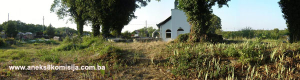
Brštanica is the central settlement in Donje (Lower) Hrasno. The necropolis is in the middle of the village, on a plateau by Jurkovića kuća, between the school and village playground and in the Roman Catholic cemetery by the church.
Historical information
Brštanica is one of a small group of villages sharing the name Donje Hrasno, which belonged to the Hum county of Žaba in mediaeval times. The earliest record of this county is in the Chronicles of the Doclean priest, usually dated to the mid 12th century. Žaba county included Mt. Žaba, the long spine of which runs east-west from the western end of the Popovo plain to the delta of the river Neretva. The broad foothills of the mountain reach to the sea at the Pelješac (Ston) channel to the south and the Bregava and Krupa river basins to the north (Anđelić, 1983, 38). Until 1399, when the Republic of Dubrovnik purchased the New Lands from Bosnia’s King Dabiša, which were registered in the detailed land register of the Littoral (Republic of Dubrovnik) during King Ostoja’s reign, in 1405, the villages of Ošlje, Stupa, Topolo, Imotica, Štedro, present-day Klek, Gradina in Mala Neretva, Brštanik town/fort was built in or around 1382, and the Slivno area belonged to Žaba county (Anđelić, 1983, 37, 39; Tošić, 1982, 49). Mt. Žaba divides the county into two equal halves: the northern continental area and the coastal area south of the mountain.
The mediaeval administrative district of Hrasno was in the northern, continental area. This district was subdivided into small areas corresponding to the rural communities of Upper and Lower Hrasno (now a small group of villages sharing the same name) or to a manorial estate that was probably in Hutovo (Anđelić, 1983, 40-42).
The territory of Žaba county was equated with the Nikolić’s feudal lands at the time of lord of the county Nikola (after 1327). Although Nikola formally held the title of lord of the county, he became the first feudal lord of Žaba county and vassel of Bosnia’s ban (governor) Stjepan II Kotromanić. The Nikolić’s were the leading landowning family in Žaba county and direct descendants of Hum’s Prince Andrija (1214-1217) who, at the time of the break-up of the Hum state in the early 13th century, held Popovo, the Littoral and Žaba. The Nikolić’s family burial ground, and probably their headquarters too, was in Vranjevo village. Their family tree can be traced over eight generations, right through to vojvoda (duke) Vukačin (1436-1453). The status of the family altered with the passage of time. At times they were direct vassals of the Bosnian king, but they were more often vassals of the Sanković’s in Popovo and the Kosača’s. The landowning clan of the Šimraks or Šimraković’s are known of in Žaba county in the 15th and 16th centuries (Dinić, 1967, 15). There are also scraps of information about other figures, stewards of the Nikolić feudal lords, in this mediaeval county (Anđelić, 1983, 37-38, 42).
The earliest sources pertaining to the Vlah organization in this region date from the early Ottoman period. The villages of Svitava and Hrasno are known to have belonged to the duchy of Donji (Lower) Vlah, which also took in the Vlah communities in the environs of Stolac and Ljubinje (Ubosko, the Burmazi Vlahs). The Herzegovina sanjak was established in early 1470, but a year earlier the first census of the vilayet of Herzeg, the Herceg’s land, had been conducted. The sanjak was divided into three vilayets. At first, the area between the Neretva, Tara and Piva rivers, belonged to the Blagaj vilayet and kadiluk, and then to the large Drina kadiluk with its headquarters in Foča. Documents dating from 1473 and 1500 refer to the Primorje (Littoral) vilayet, extending from Gabela to Dračevica, which would mean that it also included the former mediaeval Žaba county (Šabanović, 1982, 156-159,161, 1967; Anđelić, 1983, 43).
2. Description of the property
The necropolis contains 74 tombstones in two groups: the north-western group outside the cemetery boundary wall close to the north-western corner of the cemetery wall, and the south-eastern group on prehistoric tumuli in the Roman Catholic cemetery by the church.
The first group contains 23 stećak tombstones, three of which are gabled, 17 chest-shaped and 3 slabs. They lie west-east. Five of them (denoted on the plan as nos. 1-5) are decorated.
The second group of stećak tombstones, located on two tumuli within the boundary wall of the Roman Catholic cemetery, is larger, with 51 tombstones, most of them on or around the tumulus to the west of the church. Five of the tombstones in this group are decorated. Most of the tombstones in this group lie north-south, with a few on the southern edge of the tumulus lying west-east or north-west/south-east.
There are eight tombstones, in the shape of large chests or slabs, on the southern tumulus outside the entrance to the church. All but one of these lie west-east.
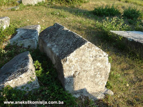
The necropolis has seven gabled tombstones, 59 chest-shaped and eight slabs, of which nos. 3 and 5 stand out in size, and one slab on the south-eastern tumulus. Most are of good workmanship, and lie west-east. Most of them are now overgrown with vegetation, both on the tumulus to the west of the church and those outside the cemetery wall. Some are damaged in part, and many have tilted or sunk into the ground. Ten of the tombstones are decorated. It would appear, from a comparison of the layout of the stećak tombstones on the plan with their present positions, that some of them, particularly around stećak no. 7 on the northern tumulus, have been shifted or pushed somewhat. The south-eastern tumulus no longer retains its natural form, its edges having been sliced off.
No. 1, Gabled, measuring 1.55 m long, 0.56 m wide, 0.8 m high (of which 0.6 is the height of the chest-shaped part). Good workmanship. Decorated in bas relief. A rope-twist runs along the base of the roof panes and across the narrower sides. Below this band and at the top of all four sides is a frieze of twining vines with trefoils. The west end, framed by a rope-twist, has a motif of two intertwined winged dragons.The east end features two infantrymen in combat, one with a sword and the other with a bow. Both are wearing plumed helmets. The north side is decorated with a deer-hunting scene: a deer, between two hunters on horseback, being chased by a dog. The south side features two men on horseback facing each other, with between them a woman holding the reins. The stećak is partly sunken and largely covered with thorny scrub, making the decorations inaccessible apart from those on the west end.
No. 2, Gabled with plinth, measuring: gabled tombstone, 1.58 x 0.58 x 1.04 m (of which 0.8 m is the height of the chest-shaped section); plinth 1.8 x 0.8 x 0.1 m. Good workmanship. The decorative motifs are in bas relief. At the base of the roof panes and across all four sides is a moulded rope-twist. All the edges of the four sides are also decorated with the same rope-twist. Below the horizontal moulded band is a frieze of twining vines with trefoils. The south side, framed by a moulded band, has a hunting scene of a horseman with a spear, in front of whom is a deer being chased by a dog.
No. 3, Slab, measuring 1.88 x 2.05 x 0.36 m. The horizontal surface is framed by a border of double incised lines along the edges.The entire surface within the border is covered with longitudinal parallel ribbing. The remains of wooden logs can be seen beneath the slab.
No. 4, Gabled on plinth, entirely overgrown with thorny scrub. There is a moulded rope-twist along the edges of the roof and narrower sides. At the top of all four sides is a bas-relief frieze with a motif of twining vines and trefoils.
No. 5, Slab, measuring 1.97 x 2.2 x 0.40 m. The top surface has a frame of oblique parallel incised lines. A motif of a rectangular shield with a sword below it is incised in the south-west corner. The frame of the shield is accentuated with deep oblique parallel lines. One corner of the slab is badly chipped.
No. 6, Chest-shaped on plinth, measuring (chest) 1.7 x 0.75 x 0.71. The plinth is a mere 0.03 m in height. The decoration is in relief. The top surface is framed by a simple moulded band, within which is a ten-lobed rosette and a stylized cross with arms widening at the ends. The lower upright extends into a slender pillar set on a stepped base, possibly representing Golgotha (Wenzel, 1964, 91). The chest has been shifted on its plinth.
No. 7, Gabled, measuring 1 x 0.49 m; height not known (0.38 m protruding above ground, of which 0.23 m is the chest). Good workmanship. A bas-relief rope-twist runs along the base of the roof and across the narrower ends. At one end the top of the ridge has been knocked off.
No. 8, Gabled on plinth, measuring (gabled) 1.7 x 0.55 (0.45) x 0.65 m (of which 0.42 m is the height of the chest); plinth 1.9 x 0.75 m, height not known (sunken). A moulded rope-twist runs across the ends level with the edge of the roof. There is damage in places, mainly along the edges. The stone is covered in places with red lichen.
No. 9, Chest-shaped, measuring 1 x 0.65 x 0.5 m. The top surface is decorated with a slanting cross with forked arms, and below it a small crescent moon. The other half of the slab bears an unusual heart-shaped motif. The workmanship of the decorations is similar to that of stećak no. 6.
No. 10, Chest-shaped, measuring 1.59 x 0.66 x 0.5 m. The corners are rounded. The top surface bears a motif of an arm bent at the elbow, the fingers outspread, in bas relief. The stećak is partly cracked.
The prehistoric tumuli within the Roman Catholic cemetery are 10 to 15 m in diameter. The edges of the tumulus south of the church have been cut off. The tumulus is about half a metre or more in height; it was reduced in height when the stećak tombstones were laid on both tumuli.
3. Legal status to date
The property is on the Provisional List of National Monuments of the Commission to Preserve National Monuments under the heading Burial ground of stećak tombstones and modern cemetery by Jurkovića kuća in Brštanica, Donje Hrasno, Municipality Neum, under serial no. 430.
The Regional Plan for BiH to 2000 listed the stećak tombstones in the Čapljina area as category III monuments.
4. Research and conservation and restoration works
Šefik Bešlagić gathered and collated information on the entire Popovo area between 1961 and 1964 (Bešlagić, 1966, 101-106).
5. Current condition of the property
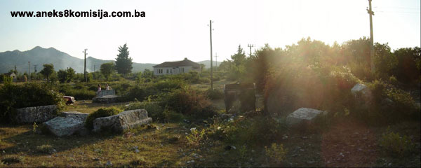
During an on site inspection on 21 July 2006 it was found that many of the tombstones have sunk into the ground and are overgrown with scrub. The area within the Roman Catholic cemetery is tidy, and the paths leading to the church and around the south-east tumulus are in good order. The tumulus west of the church, where there is the greatest concentration of stećak tombstones, is overgrown with rank vegetation and tall trees. Here it is clear that the stećak tombstones on the edges of the tumulus have been shifted out of place. The edges of the tumulus south of the entrance to the church were probably also removed when the cemetery area was being laid out, to gain more space for the cemetery.
The northern part of the necropolis, outside the cemetery wall, is in poor condition. The groups of stećak tombstones are overgrown with thorny scrub, so much so that some of the tombstones cannot be reached, nor can their decorations be seen. There is a garbage container with rubbish strewn all around it between two small groups of stećak tombstones.
6. Specific risks to which the monument is exposed
There is a large open area to the south of the northern group of stećak tombstones, outside the cemetery wall, where cars are parked close to the tombstones.
III – CONCLUSION
Applying the Criteria for the adoption of a decision on proclaiming an item of property a national monument (Official Gazette of BiH nos. 33/02 and 15/03), the Commission has enacted the Decision cited above.
The Decision was based on the following criteria:
A. Time frame
B. Historical value
C. Artistic and aesthetic value
C.iv. composition
C.v. value of details
G. Authenticity
G.i. form and design
G.v. location and setting
The following documents form an integral part of this Decision:
o Copy of cadastral plan
o Copy of land register entry
o Photodocumentation, 106 photographs taken by the Commission in July 2006
o Bešlagić, 1966, drawing of layout of stećak tombstones and 11 photographs of the tombstones
o Wenzel, 1964, drawing of a decorative motif
o Historical map of the mediaeval county of Žaba, Anđelić, 1983
Bibliography
During the procedure to designate the monument as a national monument of Bosnia and Herzegovina the following works were consulted:
1960. Bešlagić, Šefik, Stećci u Gornjem Hrasnu (Stećak tombstones in Gornje Hrasno) Naše starine VII, Sarajevo, 1960, 91-112.
1964. Wenzel, Marian, Ukrasni motivi na stećcima (Decorative motifs on stećak tombstones), Veselin Masleša, Sarajevo, 1964.
1971. Bešlagić, Šefik, Stećci, kataloško-topografski pregled (Stećak tombstones, a catalogue and topographical survey), Veselin Masleša, Sarajevo, 1971.
1982. Bešlagić, Šefik, Stećci. Kultura i umjetnost (Stećak tombstones – culture and art), Veselin Masleša, Sarajevo, 1982.
|