Status of monument -> National monument
Published in the „Official Gazette of BiH“ no. 105/06.
Pursuant to Article V para. 4 Annex 8 of the General Framework Agreement for Peace in Bosnia and Herzegovina and Article 39 para. 1 of the Rules of Procedure of the Commission to Preserve National Monuments, at a session held from 16 to 22 May 2006 the Commission adopted a
D E C I S I O N
I
The historic building of the Rustempašić tower in Odžak, Bugojno Municipality is hereby designated as a National Monument of Bosnia and Herzegovina (hereinafter: the National Monument).
The National Monument is located on a site designated as cadastral plot no. 1599, cadastral municipality Odžak (according to the new survey), Municipality Bugojno, Federation of Bosnia and Herzegovina, Bosnia and Herzegovina, including the area of the buffer zone defined in Clause III of this Decision.
The provisions relating to protection measures set forth by the Law on the Implementation of the Decisions of the Commission to Preserve National Monuments, established pursuant to Annex 8 of the General Framework Agreement for Peace in Bosnia and Herzegovina (Official Gazette of the Federation of BiH nos. 2/02, 27/02 and 6/04) shall apply to the National Monument.
II
The Government of the Federation of Bosnia and Herzegovina (hereinafter: the Government of the Federation) shall be responsible for ensuring and providing the legal, scientific, technical, administrative and financial measures necessary to protect, conserve, and display the National Monument.
The Commission to Preserve National Monuments (hereinafter: the Commission) shall determine the technical requirements and secure the funds for preparing and setting up signboards with the basic data on the monument and the Decision to proclaim the property a National Monument.
III
To ensure the on-going protection of the National Monument, the following protection zones are hereby stipulated:
Protection Zone I consists of the area defined in Clause 1 para. 2 of this Decision. The following protection measures shall apply in this zone:
- all works on the tower are prohibited other than conservation and restoration works, structural repairs, and works designed to display the monument, with the approval of the Federal Ministry responsible for regional planning (hereinafter: the relevant ministry) and under the expert supervision of the heritage protection authority of the Federation of Bosnia and Herzegovina (hereinafter: the heritage protection authority),
- a structural analysis of the state of the load-bearing walls of the tower shall be conducted, with proposed measures for its structural repair,
- to ensure the active protection of the National Monument, the tower may be adapted to revitalize its use, in line with an appropriate project design approved by the relevant ministry and under the expert supervision of the heritage protection authority,
- any eventual works on the revitalization of the building must ensure that interpolations are clearly identifiable,
- in regard to the preceding paragraph, minor alterations to the interior of the building by way of the removal of later additions of partition walls on the first and second floors of the tower are permitted,
- the former ground floor of the building may be reconstructed, as part of a later stage of development of the tower; such reconstruction must be solely for the purpose of revitalization of the use of the National Monument.
Protection Zone II consists of the area defined in Clause I para. 2 of this Decision, being an area to the north of the tower, measuring approx. 5.50 x 11 metres, and adjoining the tower. In this zone the following protection measures are hereby stipulated:
- archaeological research on the site, if considered necessary, shall be permitted with the aim of uncovereing the original structure of the boundary wall around the former residential complex of the Rustempašić tower and odžak.
On the cadastral plots within the area of the buffer zone of the National Monument,
- owners may repair existing buildings and erect new ones with the proviso that they shall not in appearance, size, use of materials and spatial relationships be to the detriment of the scenic value of the site of the National Monument and existing buildings,
- the construction of commercial facilities is prohibited,
- the dumping of all kinds of waste, stone, earth, mine waste and other solid or liquid matter is prohibited.
All protection works, regardless of their type and extent, must be carried out subject to the prior approval of the relevant ministry and under the expert supervision of the heritage protection authority.
IV
All executive and area development planning acts not in accordance with the provisions of this Decision are hereby revoked.
V
Everyone, and in particular the competent authorities of the Federation of Bosnia and Herzegovina, the Canton, and urban and municipal authorities, shall refrain from any action that might damage the National Monument or jeopardize the preservation and rehabilitation thereof.
VI
The Government of the Federation, the relevant ministry, the Federation heritage protection authority, and the Municipal Authorities in charge of urban planning and land registry affairs, shall be notified of this Decision in order to carry out the measures stipulated in Articles II to V of this Decision, and the Authorized Municipal Court shall be notified for the purposes of registration in the Land Register.
VII
The elucidation and accompanying documentation form an integral part of this Decision, which may be viewed by interested parties on the premises or by accessing the website of the Commission (http://www.aneks8komisija.com.ba)
VIII
Pursuant to Art. V para 4 Annex 8 of the General Framework Agreement for Peace in Bosnia and Herzegovina, decisions of the Commission are final.
IX
On the date of adoption of this Decision, the National Monument shall be deleted from the Provisional List of National Monuments of Bosnia and Herzegovina (Official Gazette of BiH no. 33/02, Official Gazette of Republika Srpska no. 79/02, Official Gazette of the Federation of BiH no. 59/02, and Official Gazette of Brčko District BiH no. 4/03), where it featured under serial no. 159.
X
This Decision shall enter into force on the date of its adoption and shall be published in the Official Gazette of BiH.
This Decision has been adopted by the following members of the Commission: Zeynep Ahunbay, Amra Hadžimuhamedović, Dubravko Lovrenović, Ljiljana Ševo and Tina Wik.
No: 06.1-2-211/05-5
17 May 2006
Sarajevo
Chair of the Commission
Ljiljana Ševo
E l u c i d a t i o n
I – INTRODUCTION
Pursuant to Article 2, paragraph 1 of the Law on the Implementation of the Decisions of the Commission to Preserve National Monuments, established pursuant to Annex 8 of the General Framework Agreement for Peace in Bosnia and Herzegovina, a “National Monument” is an item of public property proclaimed by the Commission to Preserve National Monuments to be a National Monument pursuant to Articles V and VI of Annex 8 of the General Framework Agreement for Peace in Bosnia and Herzegovina and property entered on the Provisional List of National Monuments of Bosnia and Herzegovina (Official Gazette of BiH no. 33/02) until the Commission reaches a final decision on its status, as to which there is no time limit and regardless of whether a petition for the property in question has been submitted or not.
The Commission to Preserve National Monuments issued a Decision to add the Rustempašić tower in Odžak to the Provisional List of National Monuments of Bosnia and Herzegovina, numbered as 149.
Pursuant to the provisions of the law, the Commission proceeded to carry out the procedure for reaching a final decision to designate the Property as a National Monument, pursuant to Article V of Annex 8 and Article 35 of the Rules of Procedure of the Commission to Preserve National Monuments.
II – PROCEDURE PRIOR TO DECISION
In the procedure preceding the adoption of a final decision to proclaim the property a national monument, the following documentation was inspected:
- Documentation on the current condition and current use of the property, including a description and photographs,
- Data on war damage, data on restoration or other works on the property, etc.
- Inspection of the current condition of the property,
- Copy of cadastral plan
- Historical, architectural and other documentary material on the property, as set out in the bibliography forming part of this Decision.
The findings based on the review of the above documentation and the condition of the site are as follows:
1. Details of the property
Location
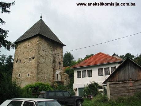
In the fertile Skoplje valley, which extends over a length of 27 kilometres and an average width of 4.5 km from Gornji Vakuf -Uskoplje via Bugojno to Donji Vakuf, midway along the Gornji Vakuf -Uskoplje to Bugojno road, a side road leads from Vrbanje to Odžak, at a distance of 4 km, on the right bank of the Vrbas river. The Rustempašić tower was built approx. 200 m. to the north-west of the mosque in the present-day centre of Odžak.
Historical information
The necropolises of stećak tombstones in Šušljici(1), the stećak tombstones in Gračanica(2) and Susid fort(3), sites in the immediate environs of Odžak, are evidence of the existence of mediaeval settlements. In the years following the conquest of Bosnia by the Ottomans in 1463, the Skoplje valley came under their rule. At this time, Uskoplje was a sizeable nahija, extending along the upper Vrbas valley on both sides of the river, and with three existing mediaeval fortified towns: Susid, Vesela Straža and Prusac, as well as the market in Gračanica(4). Vesela Straža was abandoned at the outset, and Susid fort lost its importance, but from the end of the 16th century Prusac was the political and cultural centre of the župa (county) of Skoplje and the official centre of the nahije(5) from 1580 to 1878.
Gornji Vakuf, and later Bugojno also, were crafts centres, while Donji Vakuf, Odžak and Jemanlići were the holdings of feudal lords(6).
The Rustempašić towers(7) were built at the end of the 17th century. The brothers Rustem-pasha Skopljak(8) and Ali-pasha Skopljak came to the place later to be known as Odžak from some nearby place in the Skoplje valley(9). Somewhat later, the descendants of Rustem-pasha were to be called Rustempašić: Rustem-pasha's son, Gazi Ahmed-pasha, used the surname Rustempašić in 1717. Ali-pasha Skopljak's descendants were known as Alipašić until the first half of the 19th century, when they became known as Sulejmanpašić, after Sulejman-pasha Skopljak. The Rustempašić and Sujelmanpašić families produced two Bosnian viziers, one beglerbeg (supreme military and civilian commander of a district or province) and five Klis sandžakbegs (governors of a sanjak); without doubt, the two best-known figures are Ahmed-pasha Rustempašić(10) and Sulejman-pasha Skopljak(11).
Like many other towers(12) in Bosnia and Herzegovina, the inspiration for their architectural form and appearance was based on the older residential towers of the mediaeval nobility, built within fortified towns.
The first to be built was the Gazi-Ahmed-pasha tower, by Rustem-pasha (Ahmed-pasha's father). It was 15 m in height and had four storeys. The basement contained a well for drinking water, the ground floor was stone-built, and the upper storeys were timber-built, with a wooden roof structure clad with shingles. This tower was burned down in 1831 during the time of Gradaščević's “Autonomy Movement”(13).
The second Rustempašić tower, which has survived to this day, was built very close to this, and at the same time.
Odžaks (a loose translation of which would be manor houses) were built in the spacious, formerly cobbled courtyard, close to the tower, for residential purposes(14). The entire residential complex was surrounded by a stone wall 3 metres in height(15). All that now survives is part of the wall, over a length of approx. 10 metres running north-south and abutting onto the south wall of the Rustempašić tower(16). As the family grew and the size of the population with it, and given that there was not enough space to build a house within the walls, residential buildings were also erected outside the fortified area, and the settlement that took shape was named Odžak after the odžaks within the walls.
About 100 metres to the south-eastof the former main gateway was a han (hostel) (17). Below the han, about 200 metres to the south-east of the Rustempašić tower, a mosque was built priorto 1754(18).
The last tower to be built in Odžak was the Sulejmanpašić tower, which dates from the end of the 18th century, and was twice set on fire(19): in 1814 and in 1831. It stood about 350 metres east of the surviving Rustempašić tower, and at the time it was built, stood outside the walls surrounding the Rustempašić odžak and tower.
According to Alija Bejtića, an “unusually large ahar”(20) was built below the Sulejmanpašić tower.
With the altered socio-political and economic circumstances of the Austro-Hungarian period, Odžak lost its former importance. The Austro-Hungarian authorities divided Bosnia into six districts, which were subdivided into subdistricts (kotars) and branches. The kotars were divided into municipalities, and these in turn into mahalas (urban residential quarters) and hamlets. At this time, Odžak formed paret of the Bugojno kotar(21) and had the status of a rural municipality. At that time, the Rustempašić family, apart from Husref effendi Rustempašić(22), who lived in the Rustempašić tower in Odžak, played no significant part in political, cultural or educational life. On the other hand, the Sulejmanpašić family retained its status as a wealthy beg (aristocratic) family and retained its property until the end of World War I.
The Austro-Hungarian authorities held population censuses, which showed that in 1879, Odžak had 55 houses and 67 flats with a population of 296; in 1885, it had 54 houses and 56 flats with a population of 276; in 1895, it hade 52 houses and 50 flats with a population of 228; in 1910, it had 47 houses and 40 flats with a population of 257. These census figures show that the number of houses and flats, as well as the population, was dwindling as people moved from Odžak to Bugojno, Gornji Vakuf and Turkey(23).
Just before World War II, the descendants of the old local Sulejmanpašić and Rustempašić families, two Mandžić families and one Ždralović family (who had moved in from the village of Ždralovići near Prusac) were living in Odžak. At that time, Alibeg Rustempašić was living in the Rustempašić tower(24).
The tower is now privately owned by Semin Rustempašić(25).
2. Description of the property
The tower belongs to the residential type of feudal house (or «spahi's» tower, as Prof. Hamdija Kreševljaković calls them in his work)(26).
The tower was originally designed to house the military and servants; it was only in the 19th century that it was converted to residential use(27).
The tower has a square ground plan with the sides measuring approx. 8 metres(28). It is approx. 15 m in height to the base of the roof. It is built of limestone; the corners of the building are composed of interlinked blocks of regular ashlar (the quoins are of blocks approx. 70-100 cm long and approx. 35-50 cm in height); the window and door frames are of regular ashlar; the walls are of cut stone. The ashlar quoins were dressed with a fine-toothed mason's saw, and all the facades were plastered. The tower has a basement and three storeys above (ground floor, first floor and second floor) adapted for residential purposes. Above the second storey, a third storey was built of which the ceiling was made as a stone ćemer (lit. money-belt) in the shape of a stone barrel vault above which a pyramidal timber roof structure clad with sheet metal was erected.
The tower is entered through an oak door with iron fittings on the outside. The exterior doorway is arched(29), and measures 81 cm wide x 165 cm high, from floor level to the top of the opening). Another doorway approx. 120 cm wide was more recently pierced into the basement in the north wall at the point where it meets the east wall of the tower(30).
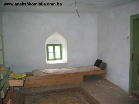
The ground, first and second storeys of the tower originally each had a corridor (measuring 262 x 607 cm on the ground floor, 243 x 620 cm on the first floor and 259 x 620 cm on the second floor) in which a wooden staircase was set against the north wall leading from one floor to the next; and a sizeable room (measuring 345 x 620 cm on the ground floor, 366 x 620 cm on the first floor, and 344 x 620 cm on the second floor), separated by a wall approx. 15 cm thick. The effects of converting the tower for residential purposes can be seen in the division of the large room on the first floor (the area by the east wall has been shortened by building in a bathroom-cum-wardrobe approx. 110 cm wide) and the second floor (the room has been divided by a partition wall into two smaller rooms) and the shortening of the corridor on the second floor by the introduction of an en-suite bathroom). The ceilings of the ground, first and second floor rooms are approx. 247 to 250 cm high.
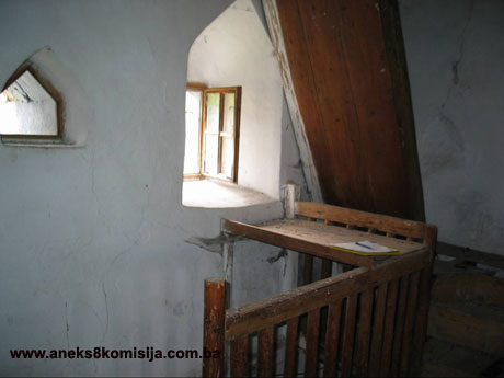
The topmost storey of the tower has a stone barrel vault with a thickness of approx. 25 cm, spanning the tower from the east to the west wall, with the rise of the vault measuring approx. 286 cm from floor level to the apex of the vault, measured on the inside. Unlike the three storeys below this, the interior space of this storey, the ceiling of which is like a stone «ćemer», is lit by the very sparse natural light that penetrates through two apertures(31): one in the north wall, which terminates in a depressed arch, measuring 47 x 58 cm (from the base to the apex of the arch) on the inside, with the parapet at approx. 167 cm from floor to base; and another in the south wall, terminating in a shallow arch, measuring approx 43 x 30 cm (from the base to the apex of the arch), with the parapet at approx. 113 cm from floor to base.There are cannon on this floor, which were fired through these apertures. This storey is reached by a steep wooden ladder with only 8 rungs, and the attic space of the vault can be reached through a hatch by the north wall of the tower.
The walls of the tower were built with a slight inwards batter(32), and their thickness also diminishes from storey to storey: in the basement they are 95 cm thick, on the ground floor 91 cm, on the first floor 87 cm, on the second floor 83 cm, and on the topmost («stone ćemer») floor they are approx. 67 cm thick(33).
The south wall of the tower has six windows, with wrought iron bars, and the west wall has five windows. When looking at this facade, it is of interest to note that the windows of the different storeys are not directly one above another. All these windows are rectangular on the outside (the measurements vary from 60 x 75 cm on the ground floor to 60 x 60 on the first floor, 60/71, 60/77 to 56/70 and 55/75 on the second floor), with stone windowframes(34); on the inside they terminate in depressed arches (the measurements on the inside, from base to apex, vary from 90/135 cm on the ground floor, 80/110, 86/114 cm on the first floor; and 81/117, 84/126 to 83/116 and 85/135 on the second floor).
Roughly at window level(35) on the first floor of the tower, the north, east and south walls each have two loopholes, known as «mazgale»(36), while the west wall of the first floor has only one(37). These loopholes are now walled up on the outside with stone, but traces of them can still be seen. The interior measurements of these loopholes are approx. 32 cm wide x 37 cm high (at the apex of the slightly arched apertures on the inside), and the loopholes themselves are built entirely in line with their original function: in horizontal cross-section, they are Y-shaped(38).
Roughly at window level(39) on the second floor of the tower, the east, south and west walls each have two sizeable loopholes, while the north wall of this floor has only one loophole. These loopholes are larger in size on the inside than those of the first floor, and are of a different shape on the inside: a pentagon, the base of which is approx. 42 to 45 cm long; the sides are vertical and parallel with one another, and approx. 25 to 30 cm in height; the upper sides are at an angle, mainly symmetrical, with a length of 32 to 37 cm; the height of the pentagon from base to apex is approx. 50 to 52 cm. They are topped by a depressed arch. The exterior appearance of these apertures is highly decorative: at the top, they have a monolithic piece of stone the outer face of which is in the form of a semi-tetrahedron, and the sides are accentuated by projecting stone beams, console-style, terminating in semi-circular mouldings (as seen from the side). In his work, engineer Alija Bejtić does not describe them in detail, but ascribes the following function to them: «. . . through which the garrison, in the event of attack from outside, would fire their rifles and pour boiling water on the enemy(40). »This description makes sense, particularly if one bears in mind that the loopholes on the second floor are directly above the entrance door to the tower, which is located in the north wall(41).
All the ceilings are constructed with timber joists. The load-bearing oak beams of the ceilings, 12 x 12 cm in cross-section, are set approx. 75-77 cm apart and rest on the east and west walls of the tower across the full thickness of the walls, with the ends of the beams visible(42) on the west and east facade walls of the tower. In the basement, the floor consists of rammed clay; the ground, first and second storeys have wooden floors composed of close-set boards; and the topmost storey has a floor of rammed earth. The ceiling of the second storey of the tower has a wooden slatted šiša ceiling, while the ceilings of the ground and first floors are plastered.
On the north facade of the tower the contours can be seen of the gabled roof of a single-storey building measuring approx 5.50 m wide x 11 m long(43), which was built on to the north of the tower. According to Semin Rustempašić(44), this extension was altered to meet the needs of his forebears, and consisted of an entrance hall to the tower, a mutvak (kitchen) with a hearth and a servants' hall. This part was hit by a shell and demolished during the 1992-1995 war.
To the east of the tower, at ground-floor level, is a door (inside measurements of the doorway 90 x 170 cm) leading from the first floor to a closet(45) built onto the east of the tower. A photograph dating from 1941(46) shows that this was a small timber-built extension with a wooden pent roof.
3. Legal status to date
By Ruling of the National Institute for the Protection of Cultural Monuments and Natural Rarities of the People's Republic of Bosnia and Herzegovina, Sarajevo, no. 1453/50 dated 28 October 1950, the monument was a legally protected property, and by Ruling of the Institute for the Protection of Cultural Monuments of the People's Republic of Bosnia and Herzegovina, Sarajevo, no. 02-744-3 dated 14 January 1963, the Rustempašić tower in Odžak, owned by Rustempašić Alibeg, son of the late Ferhat, was entered in the Register of immovable cultural monuments.
The property is on the Provisional List of the Commission to Preserve National Monuments of Bosnia and Herzegovina under the heading Rustempašić tower in Odžak, serial no. 159.
4. Research and conservation and restoration works
There is no available data on any restoration or conservation works. In 1997 the owner of the building replaced the damaged roof structure (new rafters approx. 7 m long set approx. 70 cm were installed) and the damaged shingle cladding was replaced by sheet copper laid on inch-thick boards. During these works, the original timber structure of the roof was retained, as was the original geometry of the roof jacket, with the angles of the roof surfaces identical to those of the roof prior to these works.
5. Current condition of the property
In general terms, the building has been protected from further deterioration, given that in 1997 the roof structure and cladding were replaced, as a result of which it is no longer exposed to the damaging effects of atmospheric moisture(47).
On the east and south walls and part of the west wall, there are visible vertical structural cracks (particularly on the south and east walls) extending across all the storeys. The cracks are widest on the south facade, approx. 1-2 cm, and are weakening the building, particularly should an earthquake occur, but are not a direct threat to the stability of the building.
Since the building has not been in use of any kindfor a long time, the interior is in a much neglected state: the floors, plastered surfaces and fixtures and fittings. There are also visible signs of various water and drainage pipes, which create a poor impression of the building.
6. Specific risks
The building is currently not in use, and is unsuitable for residential purposes; the owner is not living there.
III – CONCLUSION
Applying the Criteria for the adoption of a decision on proclaiming an item of property a national monument (Official Gazette of BiH nos. 33/02 and 15/03), the Commission has enacted the Decision cited above.
The Decision was based on the following criteria:
A. Time frame
B. Historical value
C. Artistic and aesthetic value
C. i. quality of workmanship
C.ii. quality of materials
C.iii. proportions
C.iv. composition
C. v. value of details
C.vi. value of construction
D. Clarity
D. iv. evidence of a particular type, style or regional manner
D. v. evidence of a typical way of life at a specific period
E. Symbolic value
E.iii. traditional value
E.v. significance for the identity of a group of people
F. Townscape/ Landscape value
F.i. relation to other elements of the site
F.ii. meaning in the townscape
F.iii. the building or group of buildings is part of a group or site
G. Authenticity
G.i. form and design
G.ii. material and content
G.iv. traditions and techniques
G.v. location and setting
The photodocumentation and drawings cited below and annexed to this Decision form an integral part thereof:
- Legal documentation
o Map indicating protection zones
o Rustempašić tower, copy of cadastral plan, c.p.. 1599, c.m. Odžak, Plan no. 9, scale 1:2500, issued on 17.08.2005. by the Municipal Geodetics Authority of Bugojno, Municipality Bugojno, Central Bosnian Canton, Federation of Bosnia and Herzegovina, Bosnia and Herzegovina,
o Rustempašić tower, Land Registry entry, c.p. no.. 67/2, cadastral municipality Gornji Odžak, Nar. no. 2269/05, entry no. 1566, issued on 17.08.2005. by the Land Register Office of the Municipal Court in Bugojno, Central Bosnian Canton, Federation of Bosnia and Herzegovina, Bosnia and Herzegovina,
o Rustempašić tower, excerpt from title deeds no. 521/06, plot no. 1599 (new survey), c.m. Odžak, issued by the Municipal Service for Property Rights, Residential and Communal, Geodetic-Cadastral and Town Planning Affairs, Bugojno Municipality, Central Bosnian Canton, Federation of Bosnia and Herzegovina, Bosnia and Herzegovina, on 16.08.2005 under reference 05-30-3/2106,
o Ruling of the Institute for the Protection of Cultural Monuments of the People's Republic of Bosnia and Herzegovina, Sarajevo, no. 02-744-3 dated 14.01.1963 on the protection of the Rustempašić tower in Odžak.
- Photographs of its former condition (source: works listed in the bibliography)
- Photographs of the property taken on 17.08.2005 (by architect Emir Softić)
- Drawing – sketch of current condition – floor plan of the storeys of the Rustempašić tower (architectural drawings, with basic scales, 17.08.2005, measured and drawn by architect Emir Softić)
Bibliography
During the procedure to designate the historic building of the Rustempašić tower in Odžak near Bugojno as a national monument of Bosnia and Herzegovina the following works were consulted:
1900. Bašagić, Safvet-beg, Kratka uputa u prošlost Bosne i Hercegovine: (od g. 1463-1850) (Brief Introduction to the History of BiH, 1463-1850) / Safvet beg Bašagić-Redžepašić (Mirza Safvet). - Sarajevo
1931. Bašagić, Safvet-beg, Znameniti Hrvati, Bošnjaci i Hercegovci u Turskoj carevini (Prominent Croats, Bosniacs and Herzegovinians in the Turkish Empire), Zagreb, 1931
1941. Bejtić, Alija, Odžak na Vrbasu (Odžak on the Vrbas), El-Hidaje, Sarajevo
1954. Kreševljaković, Hamdija, „Kule i odžaci u Bosni i Hercegovini“ (Towers and odžaks in BiH), Naše starine, II, Annual of the National Institute for the Protection of Cultural Monuments and Natural Rarities of NR Bosnia and Herzegovina, Sarajevo
1990. Klaić, Vjekoslav, Poviest Bosne (History of Bosnia) / Vjekoslav Klaić; [ed. and with foreword by Dubravko Lovrenović], Svjetlost, Sarajevo, 1990
1995. Isaković, Alija, Rječnik bosanskoga jezika (Dictionary of the Bosnian Language), Sarajevo
2001. Kico, Ahmed, „Nastanak, razvoj i vakifi Gračanice Skopaljske“ (Origins, development and legators of Gračanica Skopaljska), Annual 2005, 291-310, Preporod, Bugojno, Bosniac Cultural Association Preporod Municipal Association of Bugojno
2004. Hadžibegović, Iljas, „Bosanskohercegovački gradovi na razmeđu između 19. i 20. stoljeća“ (Towns of BiH at the Turn of the 19th/20th century), Historical Monographs 1, Institute of History in Sarajevo
2005. Rustempašić, Selma, „Odžak i najpoznatije porodice Rustempašići i Sulejmanpašići“ (Odžak and its Best-known Families the Rustempašić and Sulejmanpašić’s), Annual 2005, 275-290, Preporod, Bugojno, Bosniac Cultural Association Preporod Municipal Association of Bugojno
2005. Drino, Dževad, „Granica i naselja nahije Uskoplje“ (Borders and Settlements of the Uskoplje Nahija), Annual 2005, 171-198, Preporod, Bugojno, Bosniac Cultural Association Preporod Municipal Association of Bugojno
(1) Necropolis of stećak tombstones with 23 surviving stećaks, at an altitude of 1050 above sea level, 4 km to the north-east of Odžak;
(2) Site 2 km from Odžak, which developed from a former mediaeval marketplace and the settlement below the Susid fort. There is reference to it in 1444, and in Turkish defters of 1469, 1574 and 1604. (Drino, Dževad, „Granica i naselja nahije Uskoplje“, Annual 2005, Preporod, Bugojno, Bosniac Cultural Association Preporod Municipal Association of Bugojno, 179).
(3) Fortress above the village of Gračanica, built on the heights in the gorge of the river Bunta and close to the village of Kordići. In 1800, there were 5 mustafhiz (men of the garrison), a dizdar (garrison commander) and a fortress čehaja (deputy) in the fortress. The fortress was abandoned by 1833. (Drino, Dževad, „Granica i naselja nahije Uskoplje“, Annual 2005, Preporod, Bugojno, Bosniac Cultural Association Preporod Municipal Association of Bugojno, 188, 197).
(4) Hadžibegović, Iljas, Bosanskohercegovački gradovi na razmeđu između 19. i 20. stoljeća, Historical monographs 1, Institute of History in Sarajevo, 2004, p. 260
(5) The Uskoplje nahija formed part of the Klis sandžak from its foundation on 12 March 1537. godine (Drino, Dževad, „Granica i naselja nahije Uskoplje“, Annual 2005, Preporod, Bugojno, Bosniac Cultural Association Preporod Municipal Association of Bugojno, 171).
(6) Kico, Ahmed, „Nastanak, razvoj i vakifi Gračanice Skopaljske“, Annual 2005, Preporod, Bugojno, Bosniac Cultural Association Preporod Municipal Association of Bugojno, 295-296
(7) In all, three Rustempašić towers are referred to: To the west of the existing Rustempašić tower was another, older tower.:“…By this tower, to the west, the vestiges can be made out on the ground of jet another older Rustempašić tower, at the centre of which until recently the traces of a well with water in it could be discerned,…” (Bejtić, Alija, Odžak na Vrbasu, El-Hidaje, Sarajevo, 1941, 66);
“There were former two Rustempašić towers in Odžak, and they had another in Kordići by Susid. …” (Rustempašić, Selma, „Odžak i najpoznatije porodice Rustempašići i Sulejmanpašići“, Annual 2005, Preporod Bugojno, Bosniac Cultural Association Preporod Municipal Association of Bugojno, 281)
(8) “…The earliest reference to the forebears of the present-day Rustempašić family dates from 1683, when Rustem-pasha Skopljak was governor in Karamanija, and muhafiz (commander of a major fortress) of Sofia in 1689, where he died. The genealogy of his descendants is fully established. It is known that his brother Ali-pasha held a post in the Herzegovina sandžak in 1694. Rustem-pasha’s son, Gazi Osman-pasha, also held a prominent post in the Bosnian eyalet, as did his son Ibrahim pasha. …”(Rustempašić, Selma: 2005, 278)
(9) “… as confirmed by their nickname – Skopljak.” (Rustempašić, Selma: 2005, 287)
(10) In 1717 he was muhafiz of the Novi fortress, and in 1725 he was appointed as sandžak-beg of Herzegovina. In early 1727, one of the many wars between the Ottomans and the Persians broke out on the border between the two. Bosnia was required to equip and send 5,200 spahis and other soldiers to the Persian battlefield. They set off for Persia in April 1727, under the command of the Herzegovina sandžak [sic] Gazi Ahmed-beg Rustempašić and his son of the Klis sandžak Rustem—beg, to quell the insurrection in the Hamadan and Isfahan districts. A year later, in April 1728, only five hundred sick, exhausted men of that army returned to Bosnia. In 1728,. Ahmed-beg Rustempašić was appointed as vizier of the Bosnian eyalet. In 1730 he was appoinbted as beglerbeg of Rumelia, and he died while holding the post of muhafiz of Niš in 1732. (Rustempašić, Selma: 2005, 278-279)
(11) He was appointed as beglerbeg of Ćustendilo by imperial berat (decree) of 1804. In 1808 he was appointed as mutesarif (district prefect) of the Klis sandžak, and that same year he was appointed as kajmekan (deputy) to the then vizier of Bosnia, Ali-pasha Derendelija. He played a significant role in crushing the first Serbian uprising (he commanded the army that recaptured Belgrade). After that he was appointed to the post of vizier of the Bosnian pashaluk in Travnik. In 1818 he was recalled from the post of Bosnian vizier and appointed as vizier in Solun (Thessaloniki) where he died. He was buried in Kosovo Polje. His sons,: Ćor-Mustafa pasha, Ibrahim-beg and Osman-pasha (the last Bosniac vizier in Bosnia) also held high posts in the Bosnian eyalet. (Rustempašić, Selma: 2005, 279-281)
(12) “…There were formerly up to 300 or more such buildings, which merit particular attention from the architectural point of view, in Bosnia and Herzegovina. …”(Kreševljaković, Hamdija, „Kule i odžaci u Bosni i Hercegovini“, Naše starine, II, Annual of the National Institute for the Protection of Cultural Monuments and Natural Rarities of NR BiH Sarajevo, 1954, 71)
(13) (Rustempašić, Selma: 2005, 281)
(14) “…But since the towers provided little living space, separate buildings were erected for that purpose in the immediate vicinity of the tower, known as odžak or konak. … The towers were tall buildings, but the odžaks spread out horizontally. The tower always had several storeys, but the odžak (konak) was normally a two-storey building. The ground plan of the tower was almost invariably square, and only rarely rectangular, which that of the odžak was always rectangular. … The towers were stone-built, but the odžaks were built of stone, unbaked (adobe) brick and timber. …” (Kreševljaković, Hamdija: 1954, 71)
(15) “…According to Tahir Rustempašić, a retired 72-year-old economist with whom I have had several conversations over the past few months, these two towers and odžaks were surrounded by thick stone walls three metres in height and up to 90 cm thick. The stone walls were capped with shingles. Tahir clearly recalls the remains of this wall. All that now survives is a small section up to the point where the main gateway formerly stood. There were two gateways in the wall, the main gate and a goods entry for the use of the army. According to Azemina Rustempašić, a retired official with whom I have also had several conversations, the main gate was of iron and had a large doorknocker which survived until the 1940s. …” (Rustempašić, Selma: 2005, 277)
(16) On site on 17 August (op. E. Softić)
(17) In her paper, Rustempašić Selma in fact refers to this as ano ahar (=stabling for horses; Isaković, Alija: Rječnik bosanskoga jezika, Sarajevo, 1995, p. 5), but on the basis of the description given below it can be assumed to have been a han. According to Alija Isakoviću, “If one says ahar-odaja then it has only one meaning: guest room”. (note by E. Softić)
“…It was built like a fortress, surrounded by a thick wall, and was used as a hostel for passing travellers. Bed and board was free of charge for travellers and their escorts for three days. The ahar was thirty metreslong and ten metres wide, and had two storeys. The first floor of the ahar was of ashlar stone and was used as stabling for the horses. The second floor was timber-built and contained rooms for travellers. To the south of the ahar there were loopholes. The remains of the ahar are still visible, and a family house has been built on part of the wall, which now belongs to Ibrahim Rustempašić.” (Rustempašić, Selma: 2005, 277-278)
(18) In his work Odžak na Vrbasu, engineer Alija Bejtić writes of the mosque:”… We have already mentioned that among the old buildings of Odžak, in addition to the two towers, was a mosque with a stone minaret. The interior of the mosque was extremely austere, but it had a sizeable, though simple, portico. The mosque harem was surrounded by a thickstone wall, and the entrance to the harem was covered, in the form of a round cut stone arch. At the right-hand end of the harem was a maktab, which was of modern date. The Sulejmanpašić mosque is said to have been built by Sulejmanpaša Skopljak, and the portico and the wall surrounding the harem by his sons. As for the latter, I do not know whether it is true (perhaps it is?) but of the former, that the mosque was built by Sulejmanpaša Skopljak, this is likely to be wrong. This is why. Alongside the mosque, among other graves is a woman’s with a tombstone bearing an epitaph and the date 1168 AH, which is 1754-5 AD. As a rule, almost without exception, it is true to say that the graves around a mosque date from after the construction of the mosque. Even if by sheer chance Odžak was an exception, and these graves antedate the mosque, I doubt that a tombstone with the date 1168 AH (1754-5) could have survived intact while the mosque was being built, all the more so since the grave is right beside the mosque. All in all, it seems that the mosque was built prior to 1754, while Sulejmanpaša Skopljak, bearing in mind that he died at a great age in 1818, could only just have been born or been in his earliest youth.” (Bejtić, Alija, Odžak na Vrbasu, El-Hidaje, no 2.-3., Sarajevo, 1941, 69)
(19) “…That fine old man Mehmedbeg Rustempašić told me that the tower had caught fire twice, which is fully in accordance with history. There is no doubt that the tower was first set on fire in 1814, during the time of the infamous Bosnian vizier Alipasha Derendelija. The people of Sarajevo were in conflict with those of Visoko at the time, and defeated vizier Alipasha in Pirot near Travnik; the Sulejmanpašić family took his side, so that some of the people of Sarajevo and Visoko went after them as far as Odžak and set their tower on fire. The second and still worse fire was in 1831, during Husejin-kapetan Gradaščević’s movement against Sultan Mahmud II’s reforms. When Husejin-kapetan and his insurgents entered Travnik and captured the vizier, Ali Namik-pasha, since the sons of Suleman-pasha Skopljak again took the side of the Travnik vizier in favour of the Sultan’s reforms, the rebels drove the Sulejmanpašić’s all the way back to Odžak and mercilessly set fire to his manor. The people of Odžak were much surprised by this event. The Sarajevans therefore sent a town crier to go about Odžak and announce that they would not harm them, only the Sulejmanpašić’s. To this day it is often told in Odžak how during this attack the women padded the windows of the towers with mattresses and quilts to stop the bullets. After the people from Sarajevo and Visoko had set the tower and konak on fire, causing immense damage to the Sulejmanpašić’s, and had set off back to Travnik, they were met by Serbs, serfs of the Sulejmanpašić’s, below Mt Vranica, and there was much trouble there. After this disastrous fire, the tower was not rebuilt, but was abandoned by the Sulejmanpašić family, who built a large Bosnian-style house somewhat lower down. Since then the tower has been left to the ravages of time, and stone by stone the tower has been falling down, until it was levelled to the ground. …” (Bejtić, Alija:, 1941, 68)
The people of Gornji Vakuf were also actively involved in Husein-kapetan Gradaščević’s movement for Bosnia’s autonomy, all of them on his side apart from beg Sulejmanpašić of Odžak, whose estate was then laid waste.
(20) “…Immediately beneath this tower there was at one time an unusually large ahar. If one believes the accounts of the locals, that it extended from hill to hill, where they pointed out the width of the foundations, then the length of the ahar or konak could not have been less than 120 m and its width 40 m. It consisted of three parts. The first part of the ahar, to the right of the tower, housed the beg’s servants; below this section, the ground floor contained storerooms. The next one-third of the ahar served as a musafirluk (hostel) for travellers. Beneath this and the first part of the ahar, where the two parts met, there was such a large passageway from west to east that a fully-laden haycart could pass through it. The final one-third of the ahar was the women’s harem (private quarters). Two entrances led into the ahar, one from one widthways side and one from the other. There were large and unusually solid steps by the entrances. Old Mehmedbeg recounted that one Arifbeg Miralem of the Jemanlić family from Donji Vakuf entered the upper part of the ahar on horseback beside these steps when he came with wedding guests to Odžak to lead Azemina, daughter of Mustajbeg Sulejmanpašić. Behind the right-hand part of the ahar was stabling and other outbuildings. The ahar, too, was damaged beyond repair by the 1831 fire. Mehmedbeg Rustempašić remembered part of the abandoned ahar, and it is only thanks to him that we now know what it was once like. He recounted that the last part of the ahar fell down when he was a child, sitting in the maktab with the muallim [teacher], and that was some time before 1890.” (Bejtić, Alija:, 1941, 68-69)
(21) which included the entire Skoplje valley
(22) in 1898 he was a shari’a judge in Bugojno
(23) (Rustempašić, Selma: 2005, 284-287)
(24) (Bejtić, Alija:, 1941, 63-65)
(25) son of Šemso Rustempašić (according to Land Registry entry, Nar. no. 2269/05, entry no. 1566, issued on 17.08.2005. by the Land Registry office of the Municipal Court in Bugojno)
(26) “…Apart from the tower of feudal lords such towers were also build as office buildings, occupied by captains and their garrisons guarding the border. …
…The towers are also known as original houses, built around major forts, where the wealthier spent their summers. Such towers sometimes had stabling on the ground floor. In addition to the ground floor, they would have only one or two more storeys. These towers had loopholes. There were many such towers around Sarajevo, particularly in the area below Mt Igman, from Hrasnica to Vrelo Bosne (the source of the river Bosna). The same name was also used for the watchtowers alongside major roads, which were built in the same fashion as the towers of the feudal lords. …” (Kreševljaković, Hamdija: 1954, 71-73)
(27) (Rustempašić, Selma: 2005, 281-282)
(28) On 17 August 2005 the length of the north side of the tower at ground-floor level was measured and found to be 7.94 m (note by E. Softić)
(29) the rise of the arch is approx. 23 cm
(30) In the light of: the considerable width of this doorway as compared with that of the ground-floor doorway, which would have made the tower less safe at the time it was built; the fact that the a wooden ladder leads from the ground floor to the basement through a covered hatch in the floor; and its irregular shape, and since the tower was used for defence purposes during the 1992-1995 war, this basement doorway was probably pierced at that time; and finally, bearing in mind that engineer Alija Bejtić makes no reference to this doorway in his work, there are good grounds for the claim that this basement doorway is a later addition (note by E. Softić).
(31) On the outside, these apertures take the shape of oculi with a diameter of approx. 22 cm
(32) observation in site, and also visible on the photographs of the current condition of the building, taken on 17.08.2005
(33) all measurements taken on site on 17 August 2005. (note by E. Softić)
(34) on the sections of the façade from which the plaster has fallen away, in the area of the wall surface just above the windows on the outside, the stones are laid in the form of a relieving arch (note by E. Softić)
(35) Measured precisely, the height of the parapet from floor level to the base of the loopholes is approx. 120 cm, and is obviously designed to the anthropometric scale of a marksman aiming and firing his rifle through the loopholes (note by E. Softić)
(36) this is the term used by Prof. Kreševljaković in Chapter I of his work (Kreševljaković, Hamdija: 1954, 73).
(37) Describing the Rustempašić tower, architect Alija Bejtić calls these openings loopholes: “There are two sizeable loopholes on each of the four sides of the tower, through which the garrison could fire their guns in the event of attack, or pour boiling water onto the enemy.” (Bejtić, Alija, Odžak na Vrbasu, El-Hidaje, nos. 2-3, Sarajevo, 1941, 66).
(38) The aperture (which has the size of a niche of approx. 32 x 37 cm on the inside), looking outwards, beginning with a depth of approx. 30-35 cm, branches into two arms that gradually narrow towards the outside face of the wall. The frontal position of the loophole, on the exterior, is protected by a face stone. This treatment of the loopholes reduces visibility for the marksman inside the tower, but also greatly enhances his safety, and reduces the possibility of his being wounded by a bullet from the outside to a minimum (note by. E. Softić)
(39) Measured precisely, the height of the parapet from floor level to the base of the loopholes is: east wall approx. 112 cm; west wall approx. 118 cm and 128 cm; west [sic] wall approx. 137 cm; south wall approx. 142 cm (note by E. Softić).
(40) (Bejtić, Alija:, 1941, 66)
(41) There is another explanation for this. The owner of the tower, Semin Rustempašić, describes these as pigeon holes leading to a pigeon loft housing carrier pigeons. Although carrier pigeons were used to communicate with, for example, Travnik, where the vizier held court, and at the time the tower was built, it was possible, and very desirable in times of peace, and in particular in emergencies when the tower was under attack, it is more probably that the principal purpose of the apertures (of which there are seven in all on the second floor) was to act as loopholes (note by E. Softić).
(42) These are clearly the original beams of the tower. The structural detail of having the ends of the beams visible enabled the beams to “breathe properly” and to dry out and, as a result, to last for a long time (note by E. Softić)
(43) the dimensions have been taken from the copy of the cadastral plan (c.p no. 1599, c.m. Odžak, Plan no. 9, scale 1:2500, issued on 17.08.2005 by the Municipal Geodetics Authority of Bugojno, Municipality Bugojno, Central Bosnian Canton, Federation of Bosnia and Herzegovina, Bosnia and Herzegovina
(44) the present owner of the tower
(45) there are no visible traces of the presence of a close in the original layout of the tower (note by E. Softić)
(46) photograph of the Rustempašić tower published in Alija Bejtić’s work (Bejtić, Alija:, 1941, 67)
(47) A photograph of the current condition of the east façade shows signs of water running from the roof cornice over the entire height of the wall down to the ground, indicating that the roof cladding leaks and the building has thus been exposed to the damaging effects of rain and snow.
|