Status of monument -> National monument
Pursuant to Article V para. 4 Annex 8 of the General Framework Agreement for Peace in Bosnia and Herzegovina and Article 39 para. 1 of the Rules of Procedure of the Commission to Preserve National Monuments, at a session held from 14 to 20 March 2006 the Commission adopted a
D E C I S I O N
I
The historic site of the necropolis with stećak tombstones on the site of the Kaursko burial ground in Borci, Konjic Municipality, is hereby designated as a National Monument of Bosnia and Herzegovina (hereinafter: the National Monument).
The National Monument consists of a necropolis with 121 stećak tombstones.
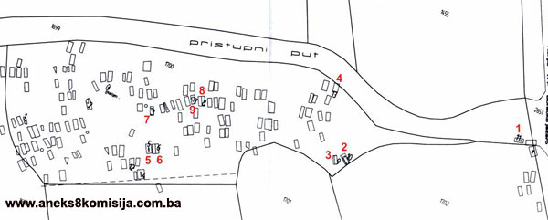
The National Monument is located on a site designated as cadastral plot no. 1700, Land Register entry no. 386/1, cadastral municipality Borci, Konjic Municipality, Federation of Bosnia and Herzegovina, Bosnia and Herzegovina.
The provisions relating to protection measures set forth by the Law on the Implementation of the Decisions of the Commission to Preserve National Monuments, established pursuant to Annex 8 of the General Framework Agreement for Peace in Bosnia and Herzegovina (Official Gazette of the Federation of BiH nos. 2/02, 27/02 and 6/04) shall apply to the National Monument.
II
The Government of the Federation of Bosnia and Herzegovina (hereinafter: the Government of the Federation) shall be responsible for ensuring and providing the legal, scientific, technical, administrative and financial measures necessary to protect, conserve, display and rehabilitate the National Monument.
The Commission to Preserve National Monuments (hereinafter: the Commission) shall determine the technical requirements and secure the funds for preparing and setting up signboards with the basic data on the monument and the Decision to proclaim the property a National Monument.
III
To ensure the on-going protection of the National Monument, the following protection zone is hereby stipulated.
Protection Zone I consists of the area defined in Clause 1 para. 3 of this Decision. The following protection measures shall apply in this zone:
- all works are prohibited with the exception of research, conservation and restoration works, routine maintenance works, and works designed to present the monument, pursuant to approval from the Federation ministry responsible for regional planning (hereinafter: the relevant ministry) and with the expert supervision of the heritage protection authority of the Federation of Bosnia and Herzegovina (hereinafter: the heritage protection authority),
- the site shall be open and accessible to the public, and may be used for educational and cultural purposes;
- infrastructural works are permitted only with the approval of the relevant ministry and the expert opinion of the heritage protection authority;
- the dumping of waste is prohibited.
Protection Zone II consists of a strip 50 m wide around the borders of the defined site, to the north, west and south. In this zone:
- the construction of full-profile roads, houses and all buildings or facilities that during construction or operation could be detrimental to the National Monument is prohibited,
- the dumping of waste is prohibited.
The Government of the Federation is required in particular to ensure that the following measures are carried out:
- Making good cracked and broken stećak tombstones
- Drawing up and implementing a programme for the presentation of the National Monument
IV
All executive and area development planning acts not in accordance with the provisions of this Decision are hereby revoked.
V
Everyone, and in particular the competent authorities of the Federation of Bosnia and Herzegovina and urban and municipal authorities, shall refrain from any action that might damage the National Monument or jeopardize the preservation thereof.
VI
The Government of the Federation, the relevant ministry, the heritage protection authority, and the Municipal Authorities in charge of urban planning and land registry affairs, shall be notified of this Decision in order to carry out the measures stipulated in Articles II to V of this Decision, and the Authorized Municipal Court shall be notified for the purposes of registration in the Land Register.
VII
The elucidation and accompanying documentation form an integral part of this Decision, which may be viewed by interested parties on the premises or by accessing the website of the Commission (http://www.aneks8komisija.com.ba)
VIII
Pursuant to Art. V para 4 Annex 8 of the General Framework Agreement for Peace in Bosnia and Herzegovina, decisions of the Commission are final.
IX
This Decision shall enter into force on the date of its adoption and shall be published in the Official Gazette of BiH.
This Decision has been adopted by the following members of the Commission: Zeynep Ahunbay, Amra Hadžimuhamedović, Dubravko Lovrenović, Ljiljana Ševo and Tina Wik.
No: 05.2-02-258/04-3
15 March 2006
Sarajevo
Chair of the Commission
Dubravko Lovrenović
E l u c i d a t i o n
I – INTRODUCTION
Pursuant to Article 2, paragraph 1 of the Law on the Implementation of the Decisions of the Commission to Preserve National Monuments, established pursuant to Annex 8 of the General Framework Agreement for Peace in Bosnia and Herzegovina, a “National Monument” is an item of public property proclaimed by the Commission to Preserve National Monuments to be a National Monument pursuant to Articles V and VI of Annex 8 of the General Framework Agreement for Peace in Bosnia and Herzegovina and property entered on the Provisional List of National Monuments of Bosnia and Herzegovina (Official Gazette of BiH no. 33/02) until the Commission reaches a final decision on its status, as to which there is no time limit and regardless of whether a petition for the property in question has been submitted or not.
On 13 October 2004 the Office of Economic, Financial and Social Affairs of Konjic Municipality submitted a proposal/petition to designate the historic site of the necropolis with stećak tombstones on the site of the Kaursko burial ground in Borci as a national monument of Bosnia and Herzegovina.
Pursuant to the provisions of the law, the Commission proceeded to carry out the procedure for reaching a final decision to designate the Property as a National Monument, pursuant to Article V of Annex 8 and Article 35 of the Rules of Procedure of the Commission to Preserve National Monuments.
II – PROCEDURE PRIOR TO DECISION
In the procedure preceding the adoption of a final decision to proclaim the property a national monument, the following documentation was inspected:
- Documentation on the location and current owner and user of the property (copy of cadastral plan and copy of land registry entry)
- Data on the current condition and use of the property, including a description and photographs, data of war damage, data on restoration or other works on the property, etc.
- Historical, architectural and other documentary material on the property.
The findings based on the review of the above documentation and the condition of the site are as follows:
1. Details of the property
Location
The village of Borci, some 20 kilometres to the south-east of Konjic, lies alongside the road leading from Konjic via Borci to Glavatičevo and beyond, along the Neretva, south-eastwards to Zaborani in the Nevesinje plain. It forks at Borak into the road that bypasses the Borak lake, to the south of which it leads south-westwards, between Prenj and Mt Crna Gora, towards Porimo and Mostar, the „Turkish road," as it is known (Anđelić, 1957, 169). With some alterations and adaptations to the route, roads ran here in mediaeval times and the Ottoman period (Anđelić, 1958, 187).
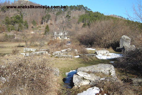
The village of Borci is located on the hilly eastern slopes of Mt. Borašnica, on the Borak plateau. The necropolis on the site of the Kaursko burial ground is in the northern part of the village of Borci, by the asphalt road from Konjic to Borci. It is located on a small elevation, from which the land slopes gently to the north and south. To the west, beyond the nearby meadows, is a brook. The necropolis thus lies on a typical site by a road with running water nearby. To the east of the road is a rising slope at the summit of which is a prehistoric hillfort.
Historical information
Archaeological material from the early and late Iron Age, and the dry wall remains on the hillfort site, are evidence that the area of Borci was inhabited in prehistoric times, at least from the start of the first millennium BCE. The Gradina hillfort is in the north-western part of the village on a slope above the Kaursko burial ground. The site of the hillfort dominates the entire area of the Borak plain, with views over to the far side of the Neretva valley. There was already a caravan route hereabouts at that time, the route of which, with minor deviations, is still that followed by the modern road. Below Gradina, on the site of the Kaursko burial ground, that is below the necropolis with stećak tombstones, are the ruins of a settlement dating from antiquity. The bumpy terrain on the surrounding plots suggest that there are the ruins of a large number of buildings. In Borci, Roman milestones have been found in some places, parts of three of which were used in the mediaeval period as tombstones within the necropolis with stećak tombstones (Anđelić, 1975, 23, 36-37, 176). In the 1880s, according to notes by Karl Patch, Philip Ballif observed the remains of Roman bricks «between the military barracks, forester's house and mediaeval burial ground.» During his visit to the site, Anđelić found a Roman brick on the other side of the road below Gradina, to the east of the Orthodox church and Cooperative Centre in Borci. At the end of this meadow were two milestones used as nišan tombstones. One of them bore the name of Emperor Julius Philippus, known as the Arab, who ruled from 247 to 249 (Anđelić, 1975, 44,58).
In the late mediaeval period the village of Borci belonged to a rural municipality the centre of which was in the Vrabač fortress, in the župa (county) of Neretva (Dinić, 1978, 223-225; Anđelić, 1982, 110). This rural municipality included not only Borci but also the villages of Gakići and Džajići. The Vrabač fortress dominated the lower Bijela valley and controlled the road that since ancient times has led up from the Neretva valley to Vrabač and Borci, whence it continues on towards Herzegovina (one fork leading to Nevesinje, the other to Potoci near Mostar) and the coast. There are references in 15th century historical sources to a customs house in Vrabač as well as to the fortress. The exact date when the fortress was built is not known. There is no reference to Vrabač prior to 1410. The customs house was probably set up by Sandalj Hranić in early 1410; it continued in use, with some breaks, as a roadside customs house as long as Herceg Stjepan, heir to Sandalj's lands, held Vrabač, until 1463. The date when Vrabač was demolished is also unknown. There are no references to Vrabač as a fortress in Ottoman sources (Dinić, 1978, 224; Anđelić, 1958,186-189). There are some rather poor sites of manganese and iron above the village of Borci, and various toponyms remain as evidence of past mining activities, such as Viganjci and Majdane (Anđelić, 1975, 280). The toponym Stolac near Borci derives from former tribal or feudal lords' tables (284).
2. Description of the property
The necropolis occupies an area of approx. 1000 m2. In the late 19th century, there were 140 tombstones in the Kaursko burial ground. There are now 121. Apart from two ridge-shaped (gabled) tombstones, the most common shapes in this necropolis are chest-shaped, slab-shaped and transitions forms between chest and slab. Some of the tombstones are shaped from almost amorphous pieces of stone, and among the stećak tombstones are three fragments of Roman milestones. The tombstones may be seen to be grouped into smaller or larger groups, with a group of 8 stećak tombstones at the entrance to the necropolis, and two separate gabled tombstones and a larger group of stećak tombstones of good workmanship about thirty metres to the west of the first group. The stećak tombstones are more closely packed at the base of the necropolis. Decorated tombstones are located at the centre of the necropolis, apart from a group at the entrance.
The necropolis is oriented west-east, with a deviation towards the north-east/south-west, following the natural lie of the land. The stećak tombstones are set in a basic direction, north-south with minor deviations, again following the natural lie of the land from north-west (head) to south-east. Only a few tombstones are set west-south, by the road that runs through the necropolis.
The workmanship of the stećak tombstones varies from well cut to almost amorphous. They were made of the local stone, which is prone to splitting, so that some of the slab-shaped stećaks, as well as being sunken, are cracked or split, mainly at the corners. The heights noted in the descriptions of the tombstones refer only to the part above ground.
The decorations on 12 stećak tombstones are in bas-relief or carved.
Stećak no. 1, chest, size 1,55x0,67x0,65. The horizontal surface bears an eight-lobed rosette surrounded by a circle with a motif of a twisted band, carved in bas-relief. The western, narrower end has a carved motif of a spiral with a stem from which two volutes branch off.
Stećak no. 2, large, monolithic gabled tombstone with plinth. The chest of the tombstone narrows towards the base. Size of the tombstone: 1.30x0,90 (0,61) x 1,65 (of which 0,45 is the height of the gable); size of the plinth: 1,95x1,05x0,60 m. About 10 cm below the edge of the ridge, the chest is decorated with a twisted band on all four sides. The gable of the head end is carved with a small four-petalled rosette surrounded by a twisted band. The decoration is in bas relief.
Stećak no. 3, small gabled tombstone set parallel to gabled tombstone no. 2. Size 1,45x0,60x0,95 (of which 0,30 m is the height of the gable). Decorated with a twisted band where the chest meets the gable. Below is a broad band with a motif of a curving band with trefoil twiner. The decoration is in bas relief.
Stećak no. 4, slab, size 1,80x1,10x0,30 m. The horizontal surface is divided down the centre by an incised line.
Stećak no. 5, chest, size 1,65x0,80x0,30 m. The horizontal surface bears a bas-relief motif of an anthropomorphic cross, the upper three arms of which terminate in circles.
Stećak no. 6, slab, size 1,20x1,20x0,35 m. The horizontal surface is divided down the centre by an incised line.
Stećak no. 7, chest, size 1.80x0,80x0,30 m. A simple cross with a longer lower arm is carved into the horizontal surface.
Stećak no. 8, slab, size 1,60x0,75x0,10 m. The horizontal surface is carved with a simple figure in prayer, arms raised and legs apart.
Stećak no. 9, slab, size 1,60x0,70x0,20 m. The horizontal surface bears a bas-relief coat of arms. It is not possible to see whether there was something else carved on the armorials.
Stećak no. 10, slab, size 1,65x1,20xo,15 m. The horizontal surface bears a bas-relief sword.
All the motifs – the anthropomorphic cross, the swords, coat of arms and praying figure, face west, while the rosette on stećak no. 2 is carved on the north-west end of the slab, where the head of the deceased was placed. This is closely associated with the position of the deceased under a slab, lying with the head facing west or north-west, looking eastwards.
The reference works state that there are 12 decorated stećak tombstones. It is impossible to make out the sword or weapon published by M. A. Wenzel, while Bešlagić thought it was a sword (Wenzel, 1964, tablee LXIV, 17; Bešlagić, 1971, 331). The other motifs are referred to in the literature.
Fragments of three antique milestones:
1. Milestone set upright, diameter of upright 0.41, height 0.70-0.75 m.
2. Overturned and partly sunken monolithic milestolne with plinth. The plinth is slightly wider, in the form of a square with chamfered edges where it meets the upright. The sides are 0.43 m long and 0.15 m high; the upright is 0.67 m high; the overall height of the milestone is 0.82 m. The upright is 0.30 m in diameter.
3. Leaning milestone, diameter of upright 0.40, height 120 m.
The necropolis dates from the late 14th to the early 16th century.
3. Legal status to date
The property is not on the Provisional List of National Monuments of the Commission to Preserve National Monuments; rather, the decision is adopted on the basis of the petition referred to above.
In the Regional Plan for BiH to 2000, the stećak tombstones of Konjic Municipality are listed as Category III monuments.
4. Research and conservation and restoration works
At the end of the 19th century, Radimsky recorded 140 stećak tombstones in the necropolis, while in the 1960s 121 were recorded (Bešlagić, 1971, 331; Anđelić, 1975, 199). No works were undertaken apart from reconnaissance.
5. Current condition of the property
An on site inspection on 2 and 8 January 2006 established that many of the tombstones are sunken or overgrown with scrub, and the local limestone from which they were made is subject to damage and deterioration as a result of weathering.
6. Specific risks to which the property is exposed
There are no specific risks.
III – CONCLUSION
Applying the Criteria for the adoption of a decision on proclaiming an item of property a national monument (Official Gazette of BiH nos. 33/02 and 15/03), the Commission has enacted the Decision cited above.
The Decision was based on the following criteria:
A. Time frame
B. Historical value
C. Artistic and aesthetic value
C.iv. composition
C. v. value of details
G. Authenticity
G.i. form and design
G.v. location and setting
H. Rarity and representativity
H.i. unique or rare example of a certain type or style
The following documents form an integral part of this Decision:
- Copy of cadastral plan
- Copy of land register entry
- Drawings – plan of the necropolis dated 2006, drawn by the Konjic Municipality surveyor
- Photodocumentation of the Commission taken on site, January 2006
Bibliography
During the procedure to designate the monument as a national monument of Bosnia and Herzegovina the following works were consulted:
1957. Anđelić, Pavao: Turski put od Ivan-planine do Porima (The Turkish route from Ivan-planina to Porimo) Naše starine, IV, Sarajevo, 1957, 169-179
1958. Anđelić, Pavao: Srednjevjekovni gradovi u Neretvi (Mediaeval towns in the Neretva) Jnl of the National Museum in Sarajevo, new series, A, XIII, Sarajevo, 1958, 179-231
1964. Wenzel, Marian, Ukrasni motivi na stećcima (Decorative motifs on stećak tombstones) Sarajevo, 1964.
1971. Bešlagić, Šefik, Stećci, kataloško-topografski pregled (Stećak tombstones, a catalogue and topographical survey), Sarajevo, 1971. 142-143.
1975. Anđelić, Pavao, Historjski spomenici Konjica i okoline I (Historic monuments of Konjic and environs), Konjic Municipal Assembly, Konjic, 1975
1978. Dinić, Mihailo, Zemlje hercega Sv. Save (Lands of Herceg St. Sava) In: Srpske zemlje u srednjem veku (Serbian lands in the mediaeval period), Belgrade, 1978, 178-269.
1982. Anđelić, Pavao, Teritorijalno politička organizacija župe Neretve i njezino mjesto u širim političkim okvirima (Territorial and political organization of the Neretva County and its place in the broader political context) In: Studije o teritorijalnopolitičkoj organizaciji srednjovjekovne Bosne (Studies on the territorial and political organization of mediaeval Bosnia). Sarajevo, 1982, 85-116.
1982. Bešlagić, Šefik, Stećci-kultura i umjetnost (Stećak tombstones – culture and art), Sarajevo, 1982.
|