Status of monument -> National monument
Pursuant to Article V para. 4 Annex 8 of the General Framework Agreement for Peace in Bosnia and Herzegovina and Article 39 para. 1 of the Rules of Procedure of the Commission to Preserve National Monuments, at a session held from 14 to 20 March 2006 the Commission adopted a
D E C I S I O N
I
The Archaeological monuments forming part of the Park in Varda below the Social Centre in Konjic are hereby designated as a National Monument of Bosnia and Herzegovina (hereinafter: the National Monument).
The National Monument consists of 13 archaeological monuments transferred from the following sites:
1. Crkvina and mekteb in Lisičići – 7 monuments of antiquity,
2. Memidžan burial ground in Lisičići – 1 isolated stećak tombstone
3. By the railways station in Lisičići – 1 isolated stećak
4. Gošića han in Ostrošac – 3 stećaks
5. Unidentified site –1 nišan tombstone
The National Monument is located on a site designated as cadastral plot no. 434, Land Register entry no. 709, cadastral municipality Konjic II, Konjic Municipality, Federation of Bosnia and Herzegovina, Bosnia and Herzegovina.
The provisions relating to protection measures set forth by the Law on the Implementation of the Decisions of the Commission to Preserve National Monuments, established pursuant to Annex 8 of the General Framework Agreement for Peace in Bosnia and Herzegovina (Official Gazette of the Federation of BiH nos. 2/02, 27/02 and 6/04) shall apply to the National Monument.
II
The Government of the Federation of Bosnia and Herzegovina (hereinafter: the Government of the Federation) shall be responsible for ensuring and providing the legal, scientific, technical, administrative and financial measures necessary to protect, conserve and display the National Monument.
The Commission to Preserve National Monuments (hereinafter: the Commission) shall determine the technical requirements and secure the funds for preparing and setting up signboards with the basic data on the monument and the Decision to proclaim the property a National Monument.
III
The following protection measures shall apply to the area defined in Clausde 1 para. 3 of this Decision.
- the Varda Park shall be maintained and designed as the Konjic lapidarium, with the aim of presenting the monuments in the park and of all Konjic’s necropolises by means of a map and suitable descriptions;
- all works on the monuments in the Park are prohibited with the exception of conservation and restoration works, routine maintenance works, and works designed to display the monument, pursuant to approval from the Federation ministry responsible for regional planning and with the expert supervision of the heritage protection authority of the Federation of Bosnia and Herzegovina (hereinafter: the heritage protection authority),
- the site of the monument shall be open and accessible to the public, and may be used for educational and cultural purposes. In this regard, a presentation of each individual monument within the Varda Park shall be provided, showingits original location and the reasons for its relocation to the park;
- infrastructural works are permitted only with the approval of the relevant ministry and the expert opinion of the heritage protection authority;
Protection Zone II consists of the slope below the Park on the left bank of the Neretva. In this zone, the construction of buildings or facilities screening or encroaching on the Park area, the construction of parking lots, and the dumping of waste are prohibited.
The Government of the Federation is required in particular to ensure that the following measures are carried out:
- making good cracked and broken stećak tombstones, and cleaning corrosion from the joints of the tombstones
- drawing up and implementing a programme for the presentation of the National Monument
IV
All executive and area development planning acts not in accordance with the provisions of this Decision are hereby revoked.
V
Everyone, and in particular the competent authorities of the Federation of Bosnia and Herzegovina, the Canton, and urban and municipal authorities, shall refrain from any action that might damage the National Monument or jeopardize the preservation thereof.
VI
The Government of the Federation, the relevant ministry, the heritage protection authority, and the Municipal Authorities in charge of urban planning and land registry affairs, shall be notified of this Decision in order to carry out the measures stipulated in Articles II to V of this Decision, and the Authorized Municipal Court shall be notified for the purposes of registration in the Land Register.
VII
The elucidation and accompanying documentation form an integral part of this Decision, which may be viewed by interested parties on the premises or by accessing the website of the Commission (http://www.aneks8komisija.com.ba)
VIII
Pursuant to Art. V para 4 Annex 8 of the General Framework Agreement for Peace in Bosnia and Herzegovina, decisions of the Commission are final.
IX
This Decision shall enter into force on the date of its adoption and shall be publi#hed in the Official Gazette of BiH.
This Decision has been adopted by the following members of the Commission: Zeynep Ahunbay, Amra Hadžimuhamedović, Dubravko Lovrenović, Ljiljana Ševo and Tina Wik.
No: 05.2-02-1026/03-4
15 March 2006
Sarajevo
Chair of the Commission
Dubravko Lovrenović
E l u c i d a t i o n
I – INTRODUCTION
Pursuant to Article 2, paragraph 1 of the Law on the Implementation of the Decisions of the Commission to Preserve National Monuments, established pursuant to Annex 8 of the General Framework Agreement for Peace in Bosnia and Herzegovina, a “National Monument” is an item of public property proclaimed by the Commission to Preserve National Monuments to be a National Monument pursuant to Articles V and VI of Annex 8 of the General Framework Agreement for Peace in Bosnia and Herzegovina and property entered on the Provisional List of National Monuments of Bosnia and Herzegovina (Official Gazette of BiH no. 33/02) until the Commission reaches a final decision on its status, as to which there is no time limit and regardless of whether a petition for the property in question has been submitted or not.
On 15 October 2004 the Office of Economic, Financial and Social Affairs of Konjic Municipality submitted a proposal/petition to designate the Archaeological Site of the Park in Varda below the Social Centre in Konjic as a national monument of Bosnia and Herzegovina.
Pursuant to the provisions of the law, the Commission proceeded to carry out the procedure for reaching a final decision to designate the Property as a National Monument, pursuant to Article V of Annex 8 and Article 35 of the Rules of Procedure of the Commission to Preserve National Monuments.
II – PROCEDURE PRIOR TO DECISION
In the procedure preceding the adoption of a final decision to proclaim the property a national monument, the following documentation was inspected:
- Data on the location and of the property and of the current owner and user (copy of cadastral plan and Land Register entry)
- Data on the current condition and use of the property, including a description and photographs, data of war damage, data on restoration or other works on the property, etc.
- Historical, architectural and other documentary material on the property, as set out in the bibliography forming part of this Decision.
The findings based on the review of the above documentation and the condition of the site are as follows:
1. Details of the property
Location
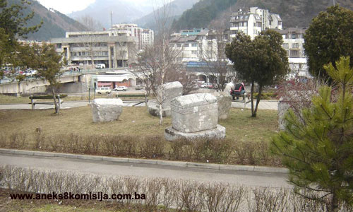
A number of stone monuments are on display in a park alongside the Jurije Gagarin bridge, part of the main Mostar road, in the centre of Konjic, on the left bank of the Neretva in Varda by the Social Centre. Eight of these are tombstones dating from antiquity, five are mediaeval stećak tombstones, and one a nišan tombstone of transitional form from the early Ottoman period. All the monuments are from sites in Lisičići and Ostrošac, areas that were flooded when the Jablanica dam was built and the Jablanica reservoir created. Access to the park is from the north, from the J. Gagarin bridge and the Social Centre, and from the west, from the Varda mosque. The high, sloping banks of the Neretva extend lie below the south and east sides of the park.
Historical information
The area around the upper Neretva straddles two regions. Since prehistoric times, the roads linking central Bosnia with the Adriatic coast ran along the Neretva valley and its outer margins. With some alterations and adaptations to the route, major roads ran here in antiquity, mediaeval times and the Ottoman period, until the road was laid through the Neretva gorge from Jablanaca to the south in the 1880s. The central Bosnian ore-rich mining area, the fertile soils of the Neretva valley, and the rich mountain pastures, all led to the formation of many settlements throughout history, in line with the conditions and demands of their respective times, on the great bend in the Neretva between the mountain massifs of Bitovnja, Bjelašnica and Visočica to the north, and Prenj and Čvrsnica to the south.
The most ancient finds in the Neretva valley date from the late stone age or Neolithic. In addition to some minor sites around Konjic, one of the most important Neolithic sites in the north-western Balkans was found in Lisičići. This dates from the late Neolithic, and is assumed to have been inhabited between 2,400 and 2,200 BCE. The archaeological material is ascribed to people from the Hrvar-Lisičići culture. The distribution of this culture suggests that the inhabitants of Lisičići were of Mediterranean origin and that they came from the south, following the Neretva river, around the mid 3rd millennium BCE.
Numerous hill forts are evidence of settlement in the region in the prehistoric metal ages (Basler, 1955, 219-223). Even before the pre-Roman era, a large, densely populated epichoric civitas or tribal territory had come into being here. Judging from finds and its position on the routes, the centre of the civitas was in Konjic (Bojanovski, 1988, 134).
The densely populated nature of the area between Konjic and Jablanica in antiquity was established by reconnaissance conducted by K. Patsch in the late 19th century and excavations carried out prior to the flooding in 1952-1954. Sites dating from antiquity have been identified in Konjic, Orahovica, Čelebići, Lisičići, Ostrošac and Ribić. Judging from the solidity and distribution of the remains of building materials, the settlements in Čelebići, Lisičići and Ostrošac were the most substantial. Parts of villae rusticae were discovered in Čelebići near the Orthodox church. The remains of three villas were found in Lisičići, one large provincial villa and two smaller ones. The villas stood alongside the local road dating from antiquity, some 3 to 5 km away along the road along the Neretva bank. The smaller villas were surrounded by walls, as is typical of settlements dating from the 4th century, when the times were already uncertain (Čremošnik, 1955,132; idem, 1957, 155; Basler, 1972, 38). A mithraeum dating from the 3rd century was found above the settlement in Lisičići, in a place called Vratnica (Anđelić, 1975, 90-102). According to the imperial gentilitia featuring on the tombstones from this region, many of the epitaphs found date from the 2nd and 3rd centuries, evidence of advancing Romanization (Bojanovski, 1988, 134). The vestiges of a late antique church dating from the 5th to 6th century were found to the west of the village (Basler, 1972, 92). The burial ground of the inhabitants of Lisičići on the right bank, where the Roman villas were found, has not been found, but later burials were identified in the tumuli on the left bank of the river, accompanied by movable items dating from antiquity. The location of the burial ground from which the steles were take to Crkvina in Lisičići were take is still not known, therefore; it is on this latter site that a church was built in the early mediaeval period, also on the right bank of the river (Čremošnik, 1954 a, 225).
In the early mediaeval period, the wider Konjic region consisted of the Neretva župa (county), part of the Zagorja župa (the area around Bjelimići) and part of the Kom župa (the area around Glavatičevo). The earliest reference to the Neretva župa is in the Chronicles of the Doclean priest, written in the mid 12th century. It lay between the župas of Rama and Kom. According to the Chronicles, the Podgorje district also belonged to it. Until the mid 11th century at the latest, the Neretva župa was part neither of Bosnia nor of Hum. By the mid 11th century the župa had presumably been incorporaated into the Bosnian state. From then on until ban (governor) Tvrtko came to power in 1355, it enjoyed special status within the Bosnian state (Anđelić, 1982, 108-110). Around the mid 14th century, heightened economic and political activities on the part of Bosnia's rulers can be traced in the Neretva župa. In the early 15th century the borders were redrawn between the later “Crown lands” and the feudal lands of the Kosača family. From 1404 to 1463, the Bosnian part of the Neretva župa belonged to the Crown lands and the Hum Neretva and Kom belonged to the feudal lands of the Kosača – later Herzegovina. The border between these two districts was the river Neretva, from the boundary of the Kom župa to that of the Rama župa. The area along the left bank of the Neretva belonged to the Kosačas, and that on the right bank to the Crown lands. In the summer of 1463 an auxiliary Ottoman army commanded by Mahmut pasha Anđelović conquered both the Neretva districts and Kom. The area known as Hum Neretva, apart from the Borovac fort, and the western part of the Bosnian Neretva, were liberated in a counter-action between July and September that same year by Herceg (Duke) Stjepan. The region was finally conquered in mid 1465 in a campaign by the Bosnian sandžakbeg Isa-beg Ishaković in the Herceg's lands (Anđelić, 1982, 110, 115-156).
In 1952 and 1953, major archaeological works were carried out on the area soon to be flooded by the Jablanica lake. The works covered the area of the Neretva and its left and right tributaries from Konjic to Jablanica and the Rama area. Following these investigative works, a number of monuments from Lisičići and Ostrošac were removed to Konjic and set up outside the Repovac mosque. They were relocated to their present site in 1978.
2. Description of the property
The park covers an area of 104 m2, and consists of three sections. From north to south, these are:
1. a somewhat raised, paved plateau with three stones. The construction of this plateau on the sloping part of the left bank of the Neretva was achieved by levelling this part of the park. The stone on the plateau is crudely cut, resembles an imitation stone monument, and bears geodetic symbols (VP=flood area) and the altitude.
2. the central section of the park consists of a wide lawn on which stand five stećak tombstones brought here from Lisičići and Ostrošac. The stećak tombstones in the park are placed in an east-west position, which is the reverse of their original position from which they were brought here (where the west was the head end, with the deceased facing east, and the east was the narrow foot end). (1)
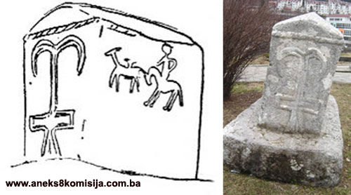
Stećak no. 1, a ridge-shaped or gabled tombstone. Limestone. Measuring 1.70 m long, 0.95 m wide, height of chest 0.68 m, overall height 1.12 m. Good workmanship, well preserved. Decorated on all sides. The transition from the chest section to the gabled section is marked all round by a moulded twisted band 5 cm thick.
At the east end, the gable bears an incised cross with cross arms bent upwards. The vertical arm has a small cross-bar at the upper end; the lower end reaches as far as the twisted band. Below the border is the carved figure of a horseman with a spear, aiming at a quadruped of some kind, the forelegs of which have buckled. Below the hunting scene, at the centre of this face, is a stylized moulded design resembling a cross (Bešlagić, 1954, 189, illus.8) or the stylized figure of a woman (Wenzel, 1964, 308 and T. LXXXI, 1). This consists of a moulded band, pointed at the top, with extensions on both sides at the top in the form of circular garlands. Lines are incised along the vertical edges of the surface, with extensions in the form of small hooks. A swastika is incised on either side of the central design. The south side has a carved design of three running deer facing west below a rope twist. Below these, in the hollows of three round-arched arcades, are three human figures with arms outstretched, a man to the east and another to the west, and a female figure in the central arcade. The figures are rather clumsily formed. The west face bears the same decoration as the east face, except that the swastika on the southern half is stylized in the form of a double swastika. The north side has a carved scene of a round dance with four figures, alternately men and women. The figures are holding hands at shoulder height. The end figures have their hands outstretched, palms outwards. The men are wearing short robes or long jerkins, and the women are wearing long dresses, tight fitting around the waist, with longitudinal pleats from the waist down. Their feet and ankles are showing. The feet of all the figures are facing to the left, meaning that the round dance is going leftwards. The men’s heads are round and those of the women are elongated. Hollows on each of the heads denote the eyes and mouth. From below the arcade all the way down to the base part of the surface protrudes; this bears a band of incised zigzag lines. At the corners these lines curve horizontally in the form of hooks (Bešlagić, 1954, 188-190, illus. 6, 8). There is minor damage to the north-west and south-east corners.
The stećak was relocated from the old Muslim burial ground known as „Memidžanovo groblje” in Lisičići. The burial ground was on the right bank of the Neretva. This, the only stećak in the burial ground, was beside a nišan tombstone (Bešlagić, 1954, 188-190). Unlike the previous period, which was rich in finds, only two isolated stećak tombstones were found in Lisičići (designated as stećak nos. 1 and 4).
Stećak no. 2, a monolithic ridge-shaped or gabled tombstone with plinth. Limestone. Measuring 1.64 m long, 0.87 (80) wide, 1.20 m high, of which the gable accounts for 0.18 m. The plinth is 20 cm wider all round than the tombstone itself. Good workmanship, well preserved. Decorated on all sides. A carved frieze of twining lines with trefoils runs round all sides below the gable, with below this in turn a twisted band 6 cm thick.
The frieze is 20 cm wide. On the east and west faces, the gable is surrounded by a twisted band. The gable are is divided by another two diagonal twisted bands, within which is a circular garland joined by the same kind of band to the top of the gable.
The east face has two rosettes with concave petals below the frieze. The rosette on the north half of the face is 26 cm in diameter, and is eight-petalled, while that on the south half of the face is 23 cm in diameter with six petals. A rectangle is incised on the lower third of the face.
The original location of this tombstone was in the „Gošića han” necropolis, where it was designated as stećak no 13 (Bešlagić,1954, 196, illus nos.18-19). The necropolis was on the right bank of the Nevizdrački brook, close to the point where it flowed into the Neretva. There was an Orthodox cemetery alongside the necropolis. The remains of an antique villa were found nearby. On both sides of the Neretva in Ostrošac, remains were found testifying to the continuity of settlement in this area from prehistoric times to the late mediaeval period.
There were 14 stećak tombstones in the „Gošića han” necropolis, lying west-east and arranged in a number of small groups. Three were moved to Konjic. There were another two necropolises with stećak tombstones in Ostrošac, on the right bank of the Neretva in a place known as Zagrebnica, about 100 m. from the Catholic church, with 12 tombstones, and in Bilice, above the railway station, with 21 monuments. On the right bank of the Neretva there were three surviving tombstones in the mosque harem, while 19 had been built into the portico and surrounding wall of the mosque (Bešlagić, 1954, 197-198).
Stećak no. 3, a monolithic ridge-shaped or gabled tombstone with plinth. Limestone. Measuring 1.64 m long, 0.87 m wide, 1 m high to the gable, overall height 1.21 m. Good workmanship, well preserved. Decorated on all sides in bas relief. A carved ropetwist band 6 cm thick runs around all four sides below the „roof.”
A stylized cross is carved on the east face, extending from about 8 cm below the twisted band to the plinth. The cross has a double vertical arm. The lower part of this arm widens somewhat at the base, while the upper section is quite long, and curves downwards on both sides at the top. The ends are narrowly pointed. The upper part of the vertical arm is anchor-shaped. The cross arm is set rather low and carved in the form of a rectangle. The cross is 84 cm high and 46 cm wide, with the arms 14 cm wide. The plinth is decorated with a border of twining lines with trefoils.
The south side features a round dance with four female figures about 57 cm in height. Below the round dance is a twisted band 6 cm thick. The raised hands of the figures are touching, with the free hands of the end figures on their hipes. They are wearing full-length robes, of simple design without any indication of pleats.
The gable of west face has a seven-petalled rosette below the twisted band. Below the band is a carved human figure in a position of prayer, with arms raised and fingers outstretched, wearing a long dress that widens at the base. An item similar to a „djed’s staff” (djed – elder of the Bosnian church – trans.) is incised on the clothing. The plinth has a carved border like that on the east face.
The north side has a carved hunting scene. In the upper half of the surface is a horseman, with a running deer ahead of him. The horseman’s head is large, his neck long, and his legs reach almost down to the ground.
In its original site in the Gošića han necropolis, this was designed as stećak no. 12. (Bešlagić,1954, 194-196, illus. nos.15-17).
Stećak no. 4, ridge-shaped or gabled, limestone. Measuring 1.37 m long, 0.66 m wide, height to the gable 0.80 m, overall height 1 m. Good workmanship, slightly chipped. Decorated on all sides. The east and west faces are decorated in identical fashion. There is a poorly worked carved twisted band at the base of the gable. The design at the centre of the rectangular section is the same as on the end faces of stećak no. 1 from the Memiđan burial ground. The south and north sides are also decorated in identical fashion. A 20 cm wide frieze of zigzag lines set with hooksis carved about 20o cm below the edge of the „roof”. Between the frieze and the roof is a hollow section in the form of a wide-ish band. There are four carved round-arched arcades below the frieze (Bešlagić, 1954, 190, illlus. 9,10).
The stećak was moved from a position about 30 m from the railway station in Lisičići, where it stood alone. In 1952 the local people told researchers that it had been twice moved before the flooding, to allow for the railway lines to be laid.
Stećak no. 5, ridge-shaped or gabled. Limestone. Measuring 1.50 m long at the top, 1.20 m at the base; 0.71 wide at the top, 0.60 m at the base; height to the gable 1.14 m, overall height 1.27 m. Good workmanship, well preserved. Decorated on all sides with incised designs. The east face has two round-arched arcades; in each arch is a rosette with 8 or 9 petals. A horizontal line is incised about 11 cm above the arcade. Above this line is a section decorated with a curved line with spirals. The south side has a 24 cm wide frieze below the „roof”, with the same design as on the east face. There is a rosette with 7 or 8 petals on each of the the west and east ends of the surface, below the frieze.
There is a similar design to that on the east face at the top of the west face, while below it two spirals can be made out, the ends of which extend towards the edges of the face and curve into hooks. The north side has a similar frieze to that of the south side. Below the frieze a single horizontal line is incised, with 10 cm below that four round-arched arcades. The span of the arcades is 24-28 cm, and their height is 54 cm. Four rosettes of 7 to 10 petals are incised within the arches.
The stećak had been damaged in places, on the upper longitudinal edges and at the corners. The damage has been filled in with cement.
In its original location in the Gošića han necropolis, this tombstone had toppled over, and was designated as stećak no. 10. It also had a plinth, which was not taken to Konjic (Bešlagić,1954, 193-194, illus. nos.12, 12 a, 13, 14).
3. Rondel, diameter 2.30 m, surrounded by a concrete wall 0.64 m high and 17 cm thick. The rondel is surrounded by one nišan tombstone and six monuments taking from antiquity. To the east of the rondel, set in grass, is part of an antique doorjamb. The description of the monuments surrounding the rondel runs clockwise from monument no. 1, to the south-east, to monument no 7, to the east of the rondel, with the right and left sides of the monuments indicated from a position looking towards the stele. The monuments are set 30 to 40 cm apart.
All the monuments dating from antiquity are from the place known as Crkvina in Lisičići, which was on the right bank of the Neretva. In 1952-1953, a mediaeval church and burial ground were discovered in Crkvina. Burials had taken place inside and around the church. Judging from its ground plan, the church was of Romanesque design, and was probably built in the 11th or 12th century. The movable items found in the graves indicated that it remained in use until the 15th century (Čremošnik, 1954, 222; Fekeža-Gavrilović, 1997, 223). The tombstones dating from antiquity found in Crkvina were in secondary positions, as structural elements of mediaeval graves. It is not known where they were brought from.
1. Nišan in the form of a stele. Limestone. The top of the nišan is broken off. Measuring height 1.10 m, width 0.44 m, thickness 0.22 m. The upper half of the nišan is decorated on three sides with motifs in bas relief. Near the top of the front face are part of a crescent moon at the centre and a rosette in the right-hand corner. Below is an arm, bent upwards at the elbow, with palm outwards and fingers outspread. On the reverse side is the carved motif of a bow and arrow. The left hand side has a pommel, hemisphere or halfmoon carved at the top, and the right hand side, facing monument no. 2, has a crescent moon design. This monument is a nišan tombstone of transitional form, dating from the second half of the 15th or the 16th century (Bešlagić, 1978, 11-13). The front lower end is damaged at a height of about 0.33 m, as is the right-hand edge. It is not known whence it was brought to the park.
2. Cipus. Limestone. Measuring 1.10 m high, 0.82 m wide, 0.60 m thick. Worked on three sides. The front face has a moulded frame within which is an 8-line inscription reading:
D(is) M(anibus) Petroni/ u(s) Maxi
Mus vivo fecit sibi /et suis/ et Aelie
Rufinae /uxori/.
Meaning:
To the shades of the departed
Petronius Maksimus makes in his own lifetime
For his [family] and his wife Aelia Rufina.
Each of the sides bears a dolphin in relief on a blank space with no moulding.
The monument dates from the late 2nd or early 3rd century. It is well preserved, with minor damage to the area with the inscription, and part of the upper surface of the left upper rear corner knocked off.
The site of the find was Crkvina in Lisičići. The monument was found in a secondary position as the cover of a reburied child’s grave no. 8 in the nave of the mediaeval church (I.Čremošnik, 1954. 214, 219-220; Anđelić, 1975, 77; Bojanovski, 1988, 135-136).
3. Part of a stele. Limestone. Measuring 0.80 m high, 0.79 m wide, 0.20 m thick. The monument has two rectangular niches, the upper of which is intact while only the upper half of the lower has survived. The frame around the niches is about 7 cm wide. The upper shallow niche features the half-length figures of a woman and two men. Because the scene is rather worn, the men can be made out to be wearing long-sleeved tunics. The outline of a fibula can be seen on the left shoulder of the man on the left. The men have short hair, rather large ears and very large eyes. The men appear to have one arm folded across their chests, holding a scroll. The woman’s head is longish, with large eyes, plaited hair, and a large headscarf. The woman is wearing a tunic with a belt. She has a chain with a heart-shaped pendent, the ends of which are attached to right and left to a clasp or fibula. On her right shoulder, a band of some kind runs from the fibula to her belt. It would seem that a cloak can also be made out. Her hands are by her sides. The lower niche features only the head of two women’s busts: the left-hand figure is a young unmarried woman, and the right-hand a married woman. The young woman’s hair is tied back, with a central parting, and tied with a ribbon resembling a diadem. The figure of the married woman is similar to the female figure in the upper niche. The fibulae fastening her tunic and cloak have survived on both shoulders. The relief is the work of a skilled workman. The stele was built into the mekteb that was built alongside the mosque in Lisičići in 1912 or 1913. The local people are known to have used stone from the nearby site in Crkvina to built the mosque in the late 19th century, and the mekteb (Patsch, 1896, 270; Sergejevski, 1935, 18-19, T.V,3; Čremošnik, 1954, 211; Anđelić, 1975, 72-73).
4. Stele. Limestone. Measuring 1.67 m high, 0.68 m wide, 0.23 m thick. Made of limestone. The stele is in the shape of a rectangle, and is divided into three equal sections. The upper section, flanked by two pilasters terminating in stylized capitals, and set on bases, features a married couple. The woman has an elonged face with large, wide-open eyes and thick hair covered with the veil worn by married woman. She is wearing a long, corseted dress with long sleeves. Her arms are by her side. She is wearing jewellery in the form of a chain and pendent, the ends of which are attached to clasps to the right and left. She is also wearing earrings. The figure of the man is quite badly worn. His long hair, a fibula on his right shoulder, and a scroll in his hand can be made out. The rectangular central section features two waist-length young women wearing corseted dresses. Both have thick, uncovered hair, meaning that they are young, unmarried women. The third section was intended for an epitaph, but was left uninscribed.
Damage to the monument is only superficial. There is minor damage to the sides and edges. There were three holes on the flat top of the stele, used to attach a separate section of the stele with two semi-recumbent lions and Atis in the centre. This section was not found. The stele was discovered in a secondary position, as the cover of grave no. 9 in the endonarthex of the mediaeval church in Lisičići (Čremošnik, 1954,a, 219,T. V, 2; Anđelić, 1975, 71-72).
5. Stele. Limestone. Measuring 1.77 m high, 0.75 m wide, and 0.37 m thick. Made of limestone. An architectural composition has been executed on a rectangular field, in the shape of a pseudoaedicule, with the busts of two women in it; below this is a moulded area for an epitaph, which has been left empty. Above the aedicule is a tympanum with a Medusa’s head at the centre, with snakes twining around her neck. Each corner of the tympanum is filled with the figure of a dolphin catching some small sea creature (a fish or polyp). The gable, with a slender beam, rests on two pilasters terminating in moulded capitals. The central scene on the stele is two women’s busts. Both have thick,plainted hair, covered by a headscarf falling down over their backs. They are dressed in belted tunics with clasps on both shoulders of the “anchor” type of fibula. Their hands are by their sides.
The stele is well preserved, with minor supervicial damage caused by flood waters. It is slightly damaged on the upper level part and lower left-hand part of the embedded part (Čremošnik, 1954, 219, tab V, 4; Anđelić, 1975, 70).
6. Stela. Limestone. Measuring 1.25 m high, 0.60 m wide, and 0.30 m thick. The stele has two sections, the upper one a rectangular aedicule featuring the busts of two figures, and below it the section for the epitaph, with a height of 0.62 m. Both sections are badly worn, and the upper edge of the aedicule was knocked off some considerable time ago, down to the top of the heads of the figures. The clothing can no longer be made out.
The epitaph in the lower aedicule reads:
D(is) M(anibus). / Aur(elio) Nu[mer ?]ia
/no fratri pie/ntissimo, def(uncto) /
an(norum) XXVI, et Aur(elio) Va /lerio av(u)ncu[l]o /,
def(unct ann(orum) XL, Aur(elius) Dazas p(ro) p(ietate).
Meaning:
To the shades of the departed. To Aurelius Numerianus,
Most pious of brothers, who died at the age of 26,
And Aurelius Valerius, uncle, who died at the age of 40,
This monument was erected in piety by Aurelius Dazas.
According to this onomastic formula, the tombstone dates from the 3rd century (Bojanovski, 1988, 137).
The stele was built into the wall of the mekteb by the mosque in Lisičići. It was used to build the church or as the cover of a grave in Crkvina. The local people used stone from the site to builc the mosque and the mekteb (Patsch, 1896, 270; Čremošnik, 1954, 212; Anđelić, 1975, 72-73). Patsch took most of the monuments found in or around Crkvina to the National Museum, including this stele (Patsch, 1896, 666-670; Čremošnik, 1954, 212). It was returned to Konjic in 1952, when the monuments were set up outside the Repovac mosque.
7. Fragment of a right-hand door jamb. Hard marlstone. Measuring 0.32 m wide, 0.87 m thick, surviving height 0.97 m. 4 cm wide angled hollow between the lower and upper sections, from a height of 0.50 m on the right to 0.70 m on the left. The lower part has survived. The front face is decorated in relief in a simple frame, with a design of a vine emerging from a vase. The vase and three bunches of grapes have survived. It was in Crkvina, and was dug up when sand was being removed prior to systematic excavations in 1952. At this time the decoration stood out well, since to all appearances the piece had been underground for a long time. The decoration is now hard to make out. It has been badly erected in the park, with the decoration on the side. It would be better if it were laid on the ground as is monument no. 8 (Čremošnik, 1954. a, 220).
8. Left-hand door jamb. Hard marlstone. Lying on the lawn to the south-east of monument no. 7. Limestone. Measuring 1.77 m high, 0.31 m wide, and 0.88 m thick. Broken into four pieces, but surviving to its full height. The front face, of fine workmanship, has a simple frame around a relief with a design of a vine emerging from a vase. The opposite side, which was against the wall, is partly worked. The door jamb was found close to the ruins of the church, at the edge of Crkvina in Lisičići. Monuments 7 and 8 are both door jambs. They have not been precisely dated, and nor have any other artifacts lacking inscriptions in Lisičići. The thickness of the doorjambs, at 0.88 m, was greater than the thickness of the wall. Both have one worked side, and the other, which was built into the wall, merely cut. From this fact, and the holes on the reverse of the door jambs to attach them to the wall, they presumably belonged to the door of a corridor of some kind (Čremošnik, 1954. a, 220).
3. Legal status to date
The monument is not on the Provisional List of National Monuments of the Commission to Preserve National Monuments; the Decision is adopted pursuant to the petition referred to above.
4. Research and conservation and restoration works
Before parts of the inhabited areas around the Jablanica reservoir were flooded in 1952-1953, the area later to be flooded was reconnoitred. Archaeological investigations were also carried out on the sites of Crkvina, the Memiđan burial ground and beneath the stećak tombstone by the railway station in Lisičići, as well as on the necropolis of stećak tombstones in Gošića han in Ostrošac. It was then that the stećak tombstones and the tombstones dating from antiquity were erected in Konjic outside the Repovac mosque. With the passage of time, this site became unsuitable, and in 1978 a project was drawn up by the design firm “Plan” from Konjic, in line with which the monuments were put on display below the Varda mosque. Since they were defaced with graffiti and at risk from the effects of bio organisms, Konjic Municipality provided funds to clean the monuments for the first time in 2005, with work to continue in 2006 on the removal of lichens from all the monuments on display. The works are being carried out by Esad Vesković MA, stone conservator of the National Museum of Bosnia and Herzegovina.
5. Current condition of the property
During an on-site inspection on January 2006 it was ascertained that there are still traces of graffiti on the monuments. Some of the stećak tombstones had already been displaced or sunken into the ground prior to their relocation in 1952-1953. They suffered no major damage while being transported to Konjic nor when being relocated to their present site in 1978. Repairs can be seen in the form of cement here and there on the monuments. Since they are carved from local limestone, the bas-relief decorations had already suffered considerable damage when in their original locations; by now, as a result of bio-damage, all the decorations, both carved and incised, are hard to make out. It is plain to see that attempts have already been made to clean the surfaces of all the stećak tombstones. However, this has left many pale stains on the tombstones, without making the decorations any easier to make out.
6. Specific risks to which the monument is exposed
No specific risks.
III – CONCLUSION
Applying the Criteria for the adoption of a decision on proclaiming an item of property a national monument (Official Gazette of BiH nos. 33/02 and 15/03), the Commission has enacted the Decision cited above.
The Decision was based on the following criteria:
A. Time frame
B. Historical value
C. Artistic and aesthetic value
C. v. value of details
G. Authenticity
G.i. form and design
The following documents form an integral part of this Decision:
- Copy of cadastral plan
- Proof of title
- Photodocumentation of the Commission taken on site in January 2006 following partial clearing of the monument
- Photodocumentation provided by Konjic Municipality to accompany required documentation
Bibliography
During the procedure to designate the monument as a national monument of Bosnia and Herzegovina the following works were consulted:
1896. Patch, Carl, Archäologisch-epigraphische Untersuchungen zur Geschichte der römischen Provinz Dalmatien. WissenschaftlicheMitteilungen aus Bosnien und der Hercegovina IV, Wien,1896.,243-295.
1935. Sergejevski, Dimitrije, Iz rimske arheologije (From Roman archaeology), Jnl of the National Museum in Bosnia and Herzegovina XLVII, Sarajevo, 1935, 17-22.
1951. Sergejevski, Dimitrije, Novi i revidirani rimski natpisi (New and revised Roman inscriptions), Jnl of the National Museum in Sarajevo, new series, vol VI, Sarajevo, 1951, 301-310.
1954. Bešlagić, Šefik, Stećci u dolini Neretve (Stećak tombstones in the Neretva valley) Naše starine II, Sarajevo, 1954, 181-212.
1954. Čremošnik, Irma, Nešto o antičkim naseljima u okolini Konjica (On the settlements of antiquity in the Konjic area) Jnl of the National Museum in Sarajevo, Archaeology, new series, vol. IX, Sarajevo, 1954, 179-188.
1954.a Čremošnik, Irma, Izvještaj o iskopavanju u Lisičićima kod Konjica. (Report on excavations in Lisičići near Konjic) Jnl of the National Museum in Sarajevo, Archaeology, new series, vol. IX, Sarajevo, 1954, 211-226.
1955. Basler, Đuro, Dolina Neretve od Konjica do Rame (Jablaničko jezero) (The Neretva valley from Konjic to Rama [Jablanica lake]) Jnl of the National Museum in Sarajevo, new series,, A, X, Sarajevo, 1955., 219-229.
1964. Wenzel Marian, Ukrasni motivi na stećcima (Decorative motifs on stećak tombstones) IP Veselin Masleša, Sarajevo,1964.
1971. Bešlagić, Šefik, Stećci, kataloško-topografski pregled (Stećak tombstones, a catalogue and topographical survey), Sarajevo, 1971. 142-143.
1972. Basler, Đuro, Arhitektura kasnoantičkog doba u Bosni i Hercegovini (Architecture of late antiquity in BiH), Sarajevo, 1972.
1975. Anđelić, Pavao, Historijski spomenici Konjica i okoline (Historic monuments of Konjic and its environs) Konjic, 1975.
1978. Bešlagić, Šefik, Nišani XV i XVI vijeka u Bosni i Hercegovini (15th and 16th century nišan tombstones in BiH) Academy of Science and Arts of BiH, Works, bk. LIII, Social Sciences Dept., bk. 30, Sarajevo, 1978.
1982. Anđelić, Pavao, Teritorijalno politička organizacija župe Neretve i njezino mjesto u širim političkim okvirima (Territorial and political organization of the Neretva County and its place in the broader political context) In: Studije o teritorijalnopolitičkoj organizaciji srednjovjekovne Bosne (Studies on the territorial and political organization of mediaeval Bosnia). Sarajevo, 1982, 85-116.
1982. Bešlagić, Šefik, Stećci-kultura i umjetnost (Stećak tombstones – culture and art), Sarajevo, 1982.
1988. Bojanovski Ivo, Bosna i Hecegovina u antičko doba (Bosnia and Herzegovina in antiquity) Academy of Science and Arts of BiH, Works, bk. LXVI, Centre for Balkan Studies, bk. 6, Sarajevo, 1978.
1997. Fekeža, Lidija i Gavrilović, Margita, Srednjovjekovne crkve u Bosni i Hercegovini (Mediaeval churches in BiH), Bosna franciscana, periodical of the Franciscan Theological College Sarajevo, yr. V, bk. 8, Sarajevo, 1997, 219-235.
(1) The description and orientation of the stećak tombstones follow their position in the park, and the description of the sides of each monument is in the order east (face), south (side), west (face), north (side).
|