Status of monument -> National monument
Pursuant to Article V para. 4 Annex 8 of the General Framework Agreement for Peace in Bosnia and Herzegovina and Article 39 para. 1 of the Rules of Procedure of the Commission to Preserve National Monuments, at a session held from 8 to 14 November 2005 the Commission adopted a
D E C I S I O N
I
The architectural ensemble of the Old Glamoč Fort in Glamoč is hereby designated as a National Monument of Bosnia and Herzegovina (hereinafter: the National Monument).
The National Monument consists of the fortress dating from the mediaeval and Ottoman periods, the mosque in the fort, and the tomb of the “Good Man. “
The National Monument is located on a site designated as cadastral plot no. 1278 (new survey), corresponding to c.p. 19/93 (old survey), title deed no. 1153, cadastral municipality Glamoč, Municipality Glamoč, Federation of Bosnia and Herzegovina, Bosnia and Herzegovina.
The provisions relating to protection measures set forth by the Law on the Implementation of the Decisions of the Commission to Preserve National Monuments, established pursuant to Annex 8 of the General Framework Agreement for Peace in Bosnia and Herzegovina (Official Gazette of the Federation of BiH nos. 2/02, 27/02 and 6/04) shall apply to the National Monument.
II
The Government of the Federation of Bosnia and Herzegovina (hereinafter: the Government of the Federation) shall be responsible for ensuring and providing the legal, scientific, technical, administrative and financial measures necessary to protect, conserve, and display the National Monument.
The Commission to Preserve National Monuments (hereinafter: the Commission) shall determine the technical requirements and secure the funds for preparing and setting up signboards with the basic data on the monument and the Decision to proclaim the property a National Monument.
III
To ensure the on-going protection of the National Monument, the following protection zones are hereby prescribed:
Protection zone I consists of the area defined in Clause 1 para. 3 of this Decision. The following protection measures shall apply in this zone:
- all works are prohibited other than research and conservation and restoration works, including those designed to display the monument, with the approval of the Federal Ministry responsible for regional planning and under the expert supervision of the heritage protection authority of the Federation of Bosnia and Herzegovina,
- the site of the monument shall be open and accessible to the public and may be used for educational and cultural purposes,
- the removal of stone is prohibited.
Protection Zone II consists of the strip from the north rampart of the fort to the Milan Gavrić street, including plot no. c.p. 1365, the entire part of plot no. 1278 to the south-west and south, part of the same plot to the north-east as far as the reservoir, and the house owned by Džim Muhamed, which stands on plot no. c.p. 1361. In this zone the construction of buildings and facilities and the extraction of stone and sand are prohibited.
Protection Zone III consists of the remainder of the plot to the north-east of the fortress, i.e. part of the area of the Upper Town. In this zone the private construction of single-storey residential buildings and the renovation of ruinous buildings to their pre-war dimensions are permitted.
To ensure the on-going protection of the site the following measures shall be implemented:
- the complete conservation of the remaining ramparts and walls of the fortress,
- during structural repair and conservation works, the use wherever possible of original materials and binders,
- during repair works, use existing stone blocks,
- the treatment of the surfaces of the repaired walls to match that of the remainder of the wall,
- the drafting and implementation of a programme for the presentation of the National Monument.
IV
All executive and area development planning acts not in accordance with the provisions of this Decision are hereby revoked.
V
Everyone, and in particular the competent authorities of the Federation of Bosnia and Herzegovina, the Canton, and urban and municipal authorities, shall refrain from any action that might damage the National Monument or jeopardize the preservation thereof.
VI
The Government of the Federation, the Federal Ministry responsible for regional planning, the Federation heritage protection authority, and the Municipal Authorities in charge of urban planning and land registry affairs, shall be notified of this Decision in order to carry out the measures stipulated in Articles II to V of this Decision, and the Authorized Municipal Court shall be notified for the purposes of registration in the Land Register.
VII
The elucidation and accompanying documentation form an integral part of this Decision, which may be viewed by interested parties on the premises or by accessing the website of the Commission (http://www.aneks8komisija.com.ba)
VIII
Pursuant to Art. V para 4 Annex 8 of the General Framework Agreement for Peace in Bosnia and Herzegovina, decisions of the Commission are final.
IX
On the date of adoption of this Decision, the National Monument shall be deleted from the Provisional List of National Monuments of Bosnia and Herzegovina (Official Gazette of BiH no. 33/02, Official Gazette of Republika Srpska no. 79/02, Official Gazette of the Federation of BiH no. 59/02, and Official Gazette of Brčko District BiH no. 4/03), where it featured under serial no. 248
X
This Decision shall enter into force on the date of its adoption and shall be published in the Official Gazette of BiH.
This Decision has been adopted by the following members of the Commission: Zeynep Ahunbay, Amra Hadžimuhamedović, Dubravko Lovrenović, Ljiljana Ševo and Tina Wik.
No: 05.2-02-230/05-3
9 November 2005
Sarajevo
Chair of the Commission
Dubravko Lovrenović
E l u c i d a t i o n
I – INTRODUCTION
Pursuant to Article 2, paragraph 1 of the Law on the Implementation of the Decisions of the Commission to Preserve National Monuments, established pursuant to Annex 8 of the General Framework Agreement for Peace in Bosnia and Herzegovina, a “National Monument” is an item of public property proclaimed by the Commission to Preserve National Monuments to be a National Monument pursuant to Articles V and VI of Annex 8 of the General Framework Agreement for Peace in Bosnia and Herzegovina and property entered on the Provisional List of National Monuments of Bosnia and Herzegovina (Official Gazette of BiH no. 33/02) until the Commission reaches a final decision on its status, as to which there is no time limit and regardless of whether a petition for the property in question has been submitted or not.
The Commission to Preserve National Monuments issued a decision to add the architectural ensemble of Glamoč – remains of the old town and fortifications to the Provisional List of National Monuments of BiH, under serial no. 248.
Pursuant to the provisions of the law, the Commission proceeded to carry out the procedure for reaching a final decision to designate the Property as a National Monument, pursuant to Article V of Annex 8 and Article 35 of the Rules of Procedure of the Commission to Preserve National Monuments.
II – PROCEDURE PRIOR TO DECISION
In the procedure preceding the adoption of a final decision to proclaim the property a national monument, the following documentation was inspected:
- Documentation on the location and current owner and user of the property
- Copy of cadastral plan and copy of land registry entry
- Data on the current condition and use of the property, including a description and photographs, data of war damage, data on restoration or other works on the property, etc.
- The current condition of the property
- Historical, architectural and other documentary material on the property, as set out in the bibliography forming part of this Decision.
The findings based on the review of the above documentation and the condition of the site are as follows:
1. Details of the property
Location
The Glamoč plain (altitude approx. 920 m above sea level) is located between high mountains: Mt Šator to the north-west, Staretina and Golija, separating it from the Livno plain to the south-west, Cincar to the south-east, while to the north of it is Hrblijne (Vitorog). The town of Glamoč is located almost at the centre of Glamoč plain, below Staretina. The fortress is on a conical hill about 100 m above the present-day town. The old fort occupies the final spur of the mountain slope, the sides of which fall away steeply to the west, north-east and east. The easiest access to the fort is from the south-west slope. First to come into being around the fortifications was the “gornja čaršija” (upper commercial area), which died out in the late 19th and early 20th century when, as a result of traffic changes, the “donja čaršija” or lower commercial area took shape alongside the road from Livno via Glamoč and Mlinište to Banja Luka (Milojević, 1923, 131; Sergejevski, 1943, 156).
Historical information
Thirty-four prehistoric hillforts have been identified on the hillsides around the Glamoč plain (Benac, 1985, 95-181). The assumption is that in antiquity, municipium Salvium was located in Vrba, about 6 km to the south-east of Glamoč, and that some 5 km north-west of Glamoč, in Halapić, was the Salviae waystation (Bojanovski, 1988, 237-239). Some few archaeological remains have been found in present-day Glamoč, in Busije, on the basis of which it is supposed that there was a settlement of some kind there in antiquity. As early as 20 CE, during the time of Dolabella’s rule, the Romans built a military road from Salona (Solin) “to the borders of the Illyric province”, part of which ran through the Glamoč plain. Later, the Salona-Servitium civilian road was built, which ran through Vrba (a municipium) and Halapić (a waystation) (Bojanovski, 1988, 244-245). Parts of church furnishings dating from early mediaeval times have been found, mainly slabs from altar partitions.
Under the governance of Bosnian rulers, the župas (counties) of Glamoč, Livno and Duvno lasted until the 14th century and the reign of ban (governor) Stjepan II Kotromanić. The Bosnian Ban meddled in the clash between the aristocratic families of Nelipić and Šubić (1324-1326), taking advantage of the fighting against the Nelipić’s to gain the Krajina, i.e. the coastal area from the mouth of the Cetina to the Neretva, along with Makarska, and the Krajina hinterland with the Imotski župa. The whole of this territory was joined to Hum, and a separate district was formedfrom the Livno, Duvno and Glamoč župas, known in historical sources as the “West side” or Završje” (Ćirković, 1964, 88, Perojević, 1998, 256, Klaić, 1994, 174). A charter of Ban Stjepan II dating from 1332, regulating relations with the Dubrovnik Republic, refers to the župan (district prefect, lord of the county) of Završje Ivan Pribilović (Anđelić, 1976, 233).
In 1357, Ban Tvrtko ceded the part of Hum land between the Neretva and the Cetina, along with Imotski, Novi and Završje, to Hungary’s King Ludovic. From then on that region was governed in the king’s name by the Croato-Dalmatian Ban. That same year the Hungarian king secretly incited the Bosnian landed aristocracy to rebellion, persuading it to break away from the Ban’s rule. A charter of Hungary’s King Ludovic dated14 March 1357 refers to Grgur Stjepanić, as lord of the fort of Glamoč. A revolt broke out in Završje, and many of the landed aristocrats, with the exception of Vlatko Vukosalić, abandoned Ban Tvrtko. These territories remained under the rule of the Hungarian king until 1387, when Ban Tvrtko and Hrvoje Vukčić Hrvatinić became involved in the dynastic struggle between King Sigismund and Ladislav of Naples (Perojević, 1998, 293-294). During these struggles, Tvrtko regained his rule over the part of Hum that had been under the rule of King Sigismund. With the help of duke Hrvoje Vukčić Hrvatinić, he gained control of the forts and župas of Duvno, Livno and Glamoč.
In the early 14th century the forts of Duvno, Livno and Glamoč were held by Pavle Maštrović Klešić, who was stripped of them by King Ostoja, as his enemy, but when he realized that he needed Klešić as an ally, he restored them to him under the terms of a charter dated 7 January 1404 (Perojević, 1998, 403-404).
There is reference in Glamoč to St Mary's church, which was not directly associated with the Franciscan monasteries (Kovačević-Kojić, 1978, 290, n.39, on p. 292).
Itis not known when the Ottomans conqueredthe forts of Glamoč, Livno and Duvno (Šabanović, 1982, 42). Until 1537 Glamoč belonged to the Bosnian sandžak and the vilayet and kadiluk of Neretva, in the King's land, headquartered in Konjic. It was part of the nahija of Dlamoč or Belgrad, the earliest reference to which dates from 1516 as a Vlah nahija in the Neretva kadiluk (Šabanović, 1982, 151-152). In 1550 and 1574 there are references to the Glamoč nahija in the Skradin kadiluk, which became part of the Klis sandžak in 1537. It remained part of that kadiluk until the end of the 17th century. The headquarters of the nahija was Glamoč, in which the governor of Klis, Malkoč beg, built a mosque in the mid 16th century. Following the loss of Klis in 1648, and of part of the Klis sandžak, the remaining nahijas in the possession of the Ottomans became part of the Livno kadiluk (Šabanović, 1982, 204-205).
During the Ottoman period the town was known as Biograd or Belgradčik (Kreševljaković, 1991, 177, n.1). In both Hungaro-Turkish treaties, that of 1503 and that of 1519, two Biograds (Prusac) are referred to, the other certainly being Glamoč. It is referred to in Ottoman sources by that time until 1833, as well as in travelogues and the reports of spies of that time. During the Ottoman period it played a major role as a border fortress.
Until the formation of the captaincy, the Glamoč fort had a dizdar (fortress commander). The Glamoč captaincy was founded after 1624, and belonged to the Klis sandžak until its fall in 1689.
A Venetian-Dalmatian source from the first half of the 17th century notes of Glamoč that it was also known as “Biogradaz”, and that the fortress had several towers (Rački, 1882, 181). In the second half of the 18th century, Glamoč was recorded as being alongside the Dalmatian border, and that the town was fairly well fortified, but that it had few artillery weapons (Bodenstein 1908, 104).
The captains of Glamoč were from the Ćirić family, and later from the Jakirlić family. The first known captain of Glamoč was Mustafa, who features in historical sources dating from 1719 and 1730. Known captains from the Jakirlić family include Ahmed kapetan, and his son Ejub who succeeded him prior to 1789 and held the post until 1789. Ibrahim beg features as captain in historical sources in 1814, and Hasan kapetan is referred to in 1818, probably as the last captain of Glamoč (Kreševljaković, 1991, 177-179).
In 1778 it faced the danger of an incursion by the Austrians.
In 1833, the fort was listed as having 11 cannon, of which 4 were not in working order, as well as a quantity of ammunition and lead, and a granary where barley and cornmeal were stored. It was probably in good order, since it did not feature on the list of forts that were to be abandoned (Kreševljaković, 1952, 159). The house belonging to the Ćirić captain family and a munitions building were located within the walls (Milojević, 1923, 131; Kreševljaković, 1953, 41). The fort was abandoned in 1851 (Kreševljaković, 1953, 41), and part of it was pulled down in 1882. The stone from the fort was sold for 12 kreuzers per metre, to the order of the district prefect (Sergejevski, 1943, 157).
2. Description of the property
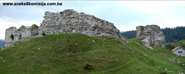
The remains of the old Glamoč fort visible on the ground probably date from the Ottoman period. Judging from historical sources, there were fortifications here in the late mediaeval period, which were adapted for firearms in the Ottoman period.
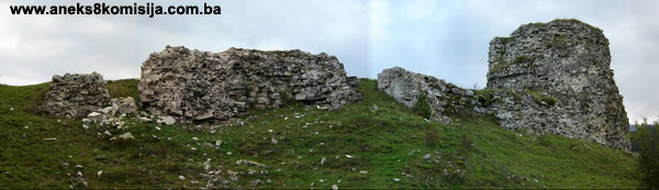
The layout of the fortifications was dictated by the lie of the land on which they were built, on a plateau on the top of a low, conical hill. They consist of an upper fortress and a bailey below it. The upper fortress occupies the relatively narrow plateau extending from the south-west to the north-east over a length of 62 m and a width of about 20 m. The plateau is surrounded on three sides by short steep slopes. The easiest access to the upper fortress is from the south-east side, which is rather lower and shorter. The upper fortress has one tabija or bastion on the south-east, most easily accessible side, perimeter ramparts to the north and south with semiprojecting towers, and a north-east rampart alongside which are the ruins of a mosque and a building of some kind. The round mediaeval keep, which was adapted into a polygonal bastion with a diameter of 9 m, can be made out in the ground plan of the heptagonal bastion. The semiprojecting towers, one each in the north and south ramparts, with walls about 6 m long, had already been adapted for firearms. The entrance to the upper fortress, which was about 1.4 m wide, was in the north rampart, about 15 m to the east of the bastion. Below this, in the lower bailey, was yet another separate gatehouse. Two buildings separated by a passageway 1.5 m wide were built at the north-east end. In the north-east corner are the vestiges of a building measuring 10 x 9 m, set alongside the rampart. The south-east wall of the building has two arched apertures 1.4 m wide, for cannon.
The ruins of the mosque are by the north-east corner of the fortifications, separated from the north-west section of the fortifications by a passageway 9.5 m long and about 3 m. wide. The mosque was built on the lower part of the ramparts surrounding the fort. It was square in ground plan, with the sides measuring 9.50 m on the inside, and three walls of which are 0.8 m thick; the fourth, south-west wall, which is 1.5 m thick, abuts onto the fortress. The mosque was built of carefully cut and laid stone. The south-east and north-east facades each have two symmetrically positioned windows measuring 1.2 x 0.8 m, with partly-preserved moulded windowjambs. Above these openings are smaller, partly-preserved rectangular attic windows with frames of thinly cut slabs. The angles of the mosque are accentuated on the exterior by regular-cut stone. The entrance to the mosque, which is 1.15 m wide, is in the north-west wall. By the entrance the wall is 0.6 m thick, with alongside it two lesser walls 0.40 m long with moulded ends, so that the entrance to the mosque is through a metre-thick aperture. The mihrab with stalactites is carved from the same stone as that used to build the mosque; it is of careful workmanship and is set in the same moulded frame as those of the windows and entrance doorway. There is a single aperture built onto the north-east wall of the mosque, made of well-cut stone beams. The mosque had a timber roof and wooden minaret.
It is not known when the mosque was built, but it may be assumed to date from the late 16th or early 17th century (Mujezinović, 1998, 133). In 1660 Çelebi refers to the mosque in the old fort as well as to a mosque in the township (Çelebi, 1979, 206). It was burned down in 1932 (Mujezinović, 1998, 133).
The upper fortress was surrounded by an enclosure the ruins of which can be made out in part on the lower edge of the plateau. Since the bastion stands on rock, it was probably surrounded by a palisade, of which no trace now remains, but the vestiges of which could still be made out in the 1930s (Sergejevski, 1943, 157). It would seem that a palisaded trench also ran along the level north-east area below the fortifications, by the present-day reservoir.
About 25 m from the bastion, on the same plot, is the tomb of the “Good Man” (Šanjta, 2003, 156). It is not known who is buried here. There is a legend associated with the grave of an unknown traveller who was buried, according to his own wishes, on the spot where his staff would be found. The tomb has a pedestal and two nišan tombstones. The pedestal, measuring 3.5 x 1.9 x 0.2 m, is made of dry-laid stone slabs. To the south-west stands the headstone, with a turban and thickened lower part (0.9 m in height), and at the north-east end is the footstone in the form of a pyramid with a rounded apex (sides 0.3 m long, height 0.7 m). The local people used to lead BOLESNO BLAGO around the tomb for healing (Šanjta, 2003, 156).
Up to the Milan Gavrić street surrounding the plot on which the Old Fort stands, on plot no. c.p.1361, is Džin Muharem's single-storey family house. The house was badly damaged during the 1992-1995 war. After the war the owner rebuilt the house. The old house has two stone plaques with incised inscriptions on the front wall to the left and right of the intrance. When rebuilding the house, the owner mounted the inscriptions from the old house in the same place as they had been before it was damaged, and the entire ground floor front has been reconstructed and is of value as a monument.
To the left of the entrance as one faces the house, the first few words of the inscription are illegible incised on the stone slab;, and the remaining letters are damaged: “…this building was erected by Salih-aga and my brother Hasan dizdar-aga, sons of Husein-aga, dizdar-aga. Year one thousand one hundred or two hundred, 1 Jumada-l-Akhira“ (23 March 1689). To the right of the entrance is another stone slab (45 x 25 cm) on which the names of the Seven Sleepers or Companions of the Cave (Ashaba al-kahf), given as “Jemliha, Mislina, Miksilina, Mernoš, Debernoš, Šadnoš, Kefeštatioš.” (1)
According to legend, these are the names of the Seven Sleepers who took shelter in a cave to escape the persecutions of the Emperor Diocletian (or Decianus) in the late 3rd or early 4th century. The Qur'an refers to the Ashaba al-Kahf, and the names from that passage are used as a talisman for protection against evil (Mujezinović, 1998, 135-136; Šanjta, 2003, 156).
3. Legal status to date
In the procedure prior to the adoption of a final decision on designation, documents on protection of the property were inspected, and the findings are as follows:
Pursuant to the provisions of the law, and by Ruling of the Institute for the Protection of Cultural Monuments of SR BiH no. 05-189-2 dated 3 March 1967, the Old Glamoč Fort, Municipality Glamoč, was placed under state protection. By Ruling no. 02-872-3 dated 18 April 1962 it was entered in the Register of immovable cultural monuments.
The architectural ensemble of the Old Glamoč Fort is on the Provisional List of National Monuments under the heading Glamoč – remains of the old town and fortifications, serial no. 248.
The Regional Plan for BiH to 2000 lists it as a Category III monument.
4. Research and conservation and restoration works
The fort has not been investigated, and there have been no conservation works.
5. Current condition of the property
It was already noted in the 1930s that little of the walls of the fort had been preserved (Mandić, 1930, 114; Sergejevski 1943, 156-157). On the bastion, only a few stones of the exterior revetment remained. Only the ground plan of the semiprojecting towers in the perimeter ramparts can be made out. The third tower below the entrance to the fort is recognizable from the place where it was built and a hollow in the ground. The above-ground sections of the perimeter ramparts are barely discernible in places, and elsewhere barely reach one metre i height. There is a pile of stone, well cut and with mouldings on some pieces, surrounds the mosque, in the passageway between the mosque and the building to the north-east of the upper fortress. The meagre remains of the ramparts of the lower bailey are barely discernible, and only in places at that.
The entire south-west section of the mosque wall and part of the south-west wall have been repaired with cement, probably to prevent them from collapsing. The interior of the mosque is partly filled with stone from the building and with rank vegetation. The passageway separating the mosque fromt he north-east section of the fortress is also full of broken stone from the mosque. There are a few moulded pieces by the entrance, which probably belonged to the mosque.
6. Specific risks to which the monument is exposed:
The entire monument is endangered.
III – CONCLUSION
Applying the Criteria for the adoption of a decision on proclaiming an item of property a national monument (Official Gazette of BiH nos. 33/02 and 15/03), the Commission has enacted the Decision cited above.
The Decision was based on the following criteria:
A. Time frame
B. Historical value
D. Clarity
D.ii. evidence of historical change
D. iv. evidence of a particular type, style or regional manner
F. Townscape/ Landscape value
F.ii. meaning in the townscape
F.iii. the building or group of buildings is part of a group or site
G. Authenticity
G.v. location and setting
The following documents form an integral part of this Decision:
- Copy of cadastral plan
- Copy of title deed nos. 1153 and 151, an important document for proof of ownership since Glamoč Municipality has no land register since World War II
- Ruling of the Institute for the Protection of Culture of SR BiH dated 18 April 1962 on entry of the Old Fort in Glamoč in the Register of protected cultural monuments
- Ruling of the Institute for the Protection of Culture of SR BiH dated 3 March 1967 to the effect that the Tabija (old fort, fortress) in Glamoč is of the nature of a cultural monument
- Photodocumentation:
- taken from the publication “Glamoč” by Šanjto Dževad
- photographs taken during on site visit in May 2005 by Lidija Fekeža
Bibliography:
During the procedure to designate the monument as a national monument of Bosnia and Herzegovina the following works were consulted:
1882. Rački, Franjo, Prilozi za geografsko-statistički opis bosanskog pašaluka (Contributions to a Geographical and Statistical Description of the Bosnian Pashaluk) Starine, Yugoslav Academy of Science and the Arts, bk. XIV. Zagreb 1992, 173-195.
1908. Bodenstein, Gustav, Povijest naselja u Posavini god 1718.-1739 (History of settlements in the Sava valley region 1718-1739) Jnl of the National Museum of Bosnia and Herzegovina XX, Sarajevo, 1908, 95-112.
1923. Milojević, Borivoj, Kupreško, Vukovsko, Ravno i Glamočko polje (The Kupreš, Vikovo, Ravno and Glamoč plain) Serbian Royal Academy, Serbian Ethnographic Proceedings, bk. 25, Belgrade, 1923, 1-154.
1930. Mandić, Mihovil, Tragovi prastare kulture oko Glamoča (Vestiges of Ancient Culture Around Glamoč) Jnl of the National Museum of Bosnia and Herzegovina, XLII, Sarajevo, 1930, 101-117.
1943. Sergejevski, Dimitrije, Putne bilješke iz Glamoča (Travel Notes from Glamoč) Jnl of the Croatian National Museum in Sarajevo, zr. LIV-1942, Sarajevo, 1943, 113-176.
1952. Kreševljaković, Hamdija, Prilozi povijesti bosanskih gradova pod turskom upravom. (Contributions to the history of Bosnian towns under Turkish rule) Contributions to oriental philology and the history of the Yugoslav peoples under Turkish rule II/1951. Sarajevo, 1952, 119-184.
1954. Kreševljaković, Hamdija-Kapidžić, Hamdija, Stari hercegovački gradovi. (Old Herzegovina towns/forts) Naše starine II, Sarajevo, 1954, 7-45
1964. Ćirković, Sima, Istorija srednjovjekovne bosanske države.(History of the mediaeval Bosnian state) Belgrade 1964.
1976. Anđelić, Pavao, Postojbina i rod Divoša Tihoradića (Homeland and Lineage of Divoš Tihoradić) Slovo, periodical of the Old Slav Institute no., 25-26, Zagreb, 1976, 231-239.
1978. Kovačević-Kojić, Desanska, Gradska naselja srednjovjekovne bosanske države.(Urban settlements of the mediaeval Bosnian state) IRO Veselin Masleša, Sarajevo, 1978.
1979. Çelebi, Evlija, Putopis odlomci o jugoslovenskim zemljama. (Travelogue: excerpts on Yugoslav lands) ed. Hazim Šabanović, IRO Veselin Masleša, Sarajevo, 1979.
1982. Šabanović, Hazim, Bosanski pašaluk. (The Bosnian pashaluk) Svjetlost, Sarajevo, 1982.
1985. Benac, Alojz, Utvrđena ilirska naselja (I) Delmatske gradine na Duvanjskom, polju, Buškom blatu, Livanjskom i Glamočkom polju (Fortified Illyrian Settlements (1) Delematian hillforts in the Duvno plain, Buško blato, and the Livno and Glamoč plains). Academy of Science and the Arts of Bosnia and Herzegovina, Bk. LX, Centre for Balkans Studies, bk. 4, Sarajevo, 1985.
1988. Bojanovski, Ivo, Bosna i Hercegovina u antičko doba. (BiH in antiquity) Academy of Science and the Arts of Bosnia and Herzegovina, Proceedings bk. LXVI, Centre for Balkan Studies, bk 6, Sarajevo, 1988.
1991. Kreševljaković, Hamdija, Kapetanije u Bosni i Hercegovini. (Captaincies in BiH) In: Selected works I, IRO “Veselin Masleša”, Sarajevo, 1991
1998. (1942.-1998.) Lukas, Filip, Bosna i Hercegovina u geopolitičkom pogledu (Bosnia and Herzegovina from a Geopolitical Perspective, History of Bosnia and Herzegovina) bk. I, HKD Napredak, Sarajevo, 1942-1991-1998, 39-77.
1998. (1942.-1998.) Perojević, Marko, Stjepan II Kotromanić. Ban Stjepan Tvrtko. Kralj Stjepan Tvrtko I. Stjepan Ostoja (Stjepan II Kotromanić, Ban Stjepan Tvrtko, King Stjepan Tvrtko I, Stjepan Ostoja History of Bosnia and Herzegovina) bk. I, HKD Napredak, Sarajevo, 1942-1991-1998, 250-349; 374-412.
1998. Mujezinović, Mehmed, Islamska epigrafika Bosne i Hercegovine, Knjiga III – Bosanska krajina, Zapadna Bosna i hercegovina (Islamic Epigraphics of BiH, Bk III, the Bosnian Krajina, Western BiH). Sarajevo, 1998.
2003. Šanjta Dževad, Glamoč (Od Ilira do Glame i krompira) (Glamoč – from the Illyrians to Glama and potatoes) Zenica, 2003.
(1) The names vary greatly in different versions of the legend: for example, “Maximillian, Jamblichos, Martin, John, Dionysios, Exakostodianos, and Antoninos (so Metaphrastes; the names vary considerably)” or “Maximian, then there was Malcus and Martinian, Dionysius and then Saraphim, there was also John and Constantine”, or “Constantius, Dionysius, Joannes, Maximianus, Malchus, Martinianus and Serapion.”
|