Status of monument -> National monument
Published in the “Official Gazette of BiH” no. 60/08.
Pursuant to Article V, Para. 4, Annex 8 of the General Framework Agreement for Peace in Bosnia and Herzegovina and Article 39, Para. 1 of the Rules of Procedure of the Commission to Preserve National Monuments, at a session held from 30 August to 5 September 2005, the Commission adopted a
D E C I S I O N
I
The architectural ensemble of the Old Maglaj Fort in Maglaj is hereby designated as a National Monument of Bosnia and Herzegovina (hereinafter: the National Monument).
The National Monument consists of a fortress dating from the mediaeval and Ottoman period and movable archaeological artefacts housed in the National Museum of Bosnia and Herzegovina in Sarajevo.
The National Monument is located on a plot designated as cadastral plot no. 2140 (new survey), corresponding to c.p. no. 1/1 (old survey), Land Register entry no. 1300, cadastral municipality Maglaj, Maglaj Municipality, Federation of Bosnia and Herzegovina, Bosnia and Herzegovina.
The provisions relating to protection measures set forth by the Law on the Implementation of the Decisions of the Commission to Preserve National Monuments, established pursuant to Annex 8 of the General Framework Agreement for Peace in Bosnia and Herzegovina (Official Gazette of the Federation of BiH nos. 2/02, 27/02 and 6/04) shall apply to the National Monument.
II
The Government of the Federation of Bosnia and Herzegovina (hereinafter: the Government of the Federation) shall be responsible for providing the legal, scientific, technical, administrative and financial measures necessary for the protection, conservation and presentation of the National Monument.
The Commission to Preserve National Monuments (hereinafter: the Commission) shall determine the technical requirements and secure the funds for preparing and setting up signboards with basic details of the monument and the Decision to proclaim the property a National Monument.
III
To ensure the on-going protection of the National Monument on the site specified in Clause I, para. 3 of this Decision, the following protection measures are hereby stipulated:
- all works are prohibited other than research and conservation and restoration works, including those designed to display the monument, with the approval of the Federal Ministry responsible for regional planning (hereinafter: the relevant Ministry) and under the expert supervision of the heritage protection authority of the Federation of Bosnia and Herzegovina (hereinafter: the heritage protection authority);
- the site of the National Monument shall be cleared, open and accessible to the public and may be used for educational and cultural purposes;
- works on the infrastructure are prohibited unless with the approval of the relevant ministry and subject to the expert opinion of the heritage protection authority;
- all construction or works that could have the effect of altering the site, and the erection of temporary facilities or permanent structures not solely designed for the protection and presentation of the National Monument, are prohibited.
To ensure the on-going protection of the National Monument, the following measures shall be implemented:
- the ramparts, the walls of the towers and other areas shall be cleared of self-sown vegetation that presents a threat to the structure of the Monument;
- structural repairs shall be carried out to the towers and ramparts where there are cracks and the risk of collapse;
- during structural repair work, conservation and restoration, original materials and binders shall be used wherever possible;
- during repair works, existing stone blocks shall be re-used;
- the missing parts of the dressed stone facing must be replaced using the same material as they were originally made of;
- the crown of the wall must be made of natural materials (capping stones or a finish of hydraulic plaster);
- self-sown vegetation must be physically removed so as not to damage the structure of the National Monument;
- a programme for the presentation of the National Monument shall be drawn up and implemented.
The buffer zone consists of plots nos. c.p.2150/1, 2148, 2147, part of 2144 (between the Mulalić fountain, Gradina and plot c.p. 2143), 2142, 2143, 2139, 2138, 2137 and 2136. The following protection measures shall apply in this zone:
- the construction of properties with a maximum height of 6.50 m to the base of the roof frame, i.e. two storeys (ground + 1), and a maximum footprint of 10 x 12 m, shall be permitted;
- the construction of major infrastructural and other properties the construction or operation of which could result in damage to the National Monument or alterations to its natural surroundings is prohibited;
- the dumping of all kinds of waste is prohibited.
IV
The removal of the archaeological artefacts specified in Clause 1 of this Decision (hereinafter; the movable heritage) from Bosnia and Herzegovina is prohibited.
By way of exception to the provision of Paragraph 1 of this Clause, the temporary removal from Bosnia and Herzegovina of the movable heritage for the purposes of display or conservation shall be permitted if it is established that conservation works cannot be carried out in Bosnia and Herzegovina.
Permission for their temporary removal from Bosnia and Herzegovina under the conditions stipulated in the preceding paragraph shall be issued by the Commission to Preserve National Monuments, if it is determined beyond doubt that it will not jeopardize the movable heritage in any way.
In granting permission for the temporary removal of the movable heritage from Bosnia and Herzegovina, the Commission shall stipulate all the conditions under which the removal may take place, the date by which the collection shall be returned to the country, and the responsibility of individual authorities and institutions for ensuring that these conditions are met, and shall notify the Government of the Federation of Bosnia and Herzegovina, the relevant security service, the customs authority of Bosnia and Herzegovina, and the general public accordingly.
V
All executive and area development planning acts not in accordance with the provisions of this Decision are hereby revoked.
VI
Everyone, and in particular the competent authorities of the Federation of Bosnia and Herzegovina, the Canton, and urban and municipal authorities, shall refrain from any action that might damage the National Monument or jeopardize the preservation thereof.
VII
The Government of the Federation, the Federation Ministry responsible for regional planning, the Federation heritage protection authority, and the Municipal Authorities in charge of urban planning and land registry affairs, shall be notified of this Decision in order to carry out the measures stipulated in Clauses II to VI of this Decision, and the Authorized Municipal Court shall be notified for the purposes of registration in the Land Register.
VIII
The elucidation and accompanying documentation form an integral part of this Decision, which may be viewed by interested parties on the premises or by accessing the website of the Commission (http://www.aneks8komisija.com.ba).
IX
Pursuant to Article V, Para 4, Annex 8 of the General Framework Agreement for Peace in Bosnia and Herzegovina, decisions of the Commission are final.
X
On the date of adoption of this Decision, the National Monument shall be deleted from the Provisional List of National Monuments of Bosnia and Herzegovina (Official Gazette of BiH no. 33/02, Official Gazette of Republika Srpska no. 79/02, Official Gazette of the Federation of BiH no. 59/02, and Official Gazette of Brčko District BiH no. 4/03), where it featured under serial no. 366.
XI
This Decision shall enter into force on the date of its adoption and shall be published in the Official Gazette of BiH.
This Decision has been adopted by the following members of the Commission: Zeynep Ahunbay, Amra Hadžimuhamedović, Dubravko Lovrenović, Ljiljana Ševo and Tina Wik.
No. 05.2-2-78/04-5
31 August 2005
Sarajevo
Chair of the Commission
Ljiljana Ševo
E l u c i d a t i o n
I – INTRODUCTION
Pursuant to Article 2, Paragraph 1 of the Law on the Implementation of the Decisions of the Commission to Preserve National Monuments, established pursuant to Annex 8 of the General Framework Agreement for Peace in Bosnia and Herzegovina, a “National Monument” is an item of public property proclaimed by the Commission to Preserve National Monuments to be a National Monument pursuant to Articles V and VI of Annex 8 of the General Framework Agreement for Peace in Bosnia and Herzegovina and property entered on the Provisional List of National Monuments of Bosnia and Herzegovina (Official Gazette of BiH no. 33/02) until the Commission reaches a final decision on its status, as to which there is no time limit and regardless of whether a petition for the property in question has been submitted or not.
The Commission to Preserve National Monuments issued a decision to add the architectural ensemble of the Old Maglaj Fort to the Provisional List of National Monuments of BiH under serial number 366.
Pursuant to the provisions of the law, the Commission proceeded to carry out the procedure for reaching a final decision to designate the Property as a National Monument, pursuant to Article V, Para 4 of Annex 8 and Article 35 of the Rules of Procedure of the Commission to Preserve National Monuments.
II – PROCEDURE PRIOR TO DECISION
In the procedure preceding the adoption of a final decision to proclaim the property a national monument, the following documentation was inspected:
- Documentation on the location and current owner and user of the property;
- Copy of cadastral plan and copy of land registry entry;
- Data on the current condition and use of the property, including a description and photographs, data of war damage if any, data on restoration or other works on the property if any, etc.;
- Current condition of the property;
- Historical, architectural and other documentary material on the property.
The findings based on the review of the above documentation and the condition of the property are as follows:
1. Details of the property
Location
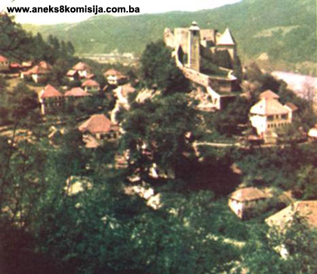
The Old Maglaj Fort stands on a site known as Gradina, on a magma outcrop that slopes steeply down to the right bank of the river Bosna. The outcrop is separated from the outermost foothills of Mt. Ozren by a valley.
The National Monument is located on a plot designated as cadastral plot no. 2140 (new survey), corresponding to c.p. no. 1/1 (old survey), Land Register entry no. 1300, cadastral municipality Maglaj, Maglaj Municipality, Federation of Bosnia and Herzegovina, Bosnia and Herzegovina.
Historical information
During archaeological investigations of the fortress in Maglaj in the early 1960s, it proved impossible to establish any continuity from prehistoric times through the Roman period to the fortress dating from the early 15th century, the first reference to Maglaj fort.
In mediaeval times Maglaj belonged to the district of Usora. In early mediaeval times there was presumably a župa (county), the name of which is not known, in the Bosna valley in the area of Žepče, Zavidovići and Maglaj. In the early days of the Ottoman administration the nahija (minor administrative region) of Maglaj was established in that region. Among the fortified towns that evolved into political centres, the only one known with certainty to have existed was Maglaj (Anđelić, 1977, 20, 17).
It has not been determined exactly when the Maglaj fort was built, but the archaeological works within the ramparts failed to confirm the hypothesis that there had been an earlier fort there. Probably, though Maglaj could already have been a county town when the “county system was still functioning,” i.e. in the 13th century (Bojanovski, 1965, 83, 1st stage of the town; Anđelić, 1977, 20).
The form of the mediaeval fortifications fits in with the time when Hungary's King Sigismund and the kings and nobility of Bosnia were at war in Bosnia (late 14th and first two decades of the 15th century). Bosnia's King Stjepan Ostoja issued a charter to Dubrovnik on 15 January 1399 as the glorious army at the Lišnica. The Liješnica river joins the Bosna river one kilometre upriver from Maglaj, and most historians believe this to be the first direct mention of events around Maglaj in mediaeval times. It remains uncertain whether the fort in Maglaj was being built at that time or was in the hands of Hungarian soldiers.
The earliest reference to Maglaj is in a charter issued by King Sigismund on 16 September 1408 sub castro nostro Maglay. Since King Sigismund wrote the charter “beneath our fort,” it may assumed that it was occupied by the Hungarian army in a new campaign in the first half of September of that year.
A quarter in Maglaj is named Varoš. According to Anđelić, urban settlements (varoš) served as commercial centres during the 14th and 15th centuries, so that despite the absence of any other information, it has to be assumed that there was a civilian settlement below the fortress in Maglaj (Anđelić, 1977, 20; Kovačević-Kojić, 1978, 82).
The Ottomans gained control of Maglaj in 1476, putting an end to the puppet kingdom founded in 1465, when the Ottomans appointed Matija Radivojević as Bosnian king. In his work on early Ottoman defters (tax registers) from the territory of Bosnia and Herzegovina, A. Handžić concluded that the Ottoman puppet statelet had covered the area of which the points of the triangle were the forts in Maglaj, Tešanj and Doboj (Handžić, 1973, 385-386). This was also the territory that drove a wedge between the boundary demarcation between the Jajce and Srebrenica banates. The Ottomans had been settling successive groups of Vlachs from Herzegovina there, even before 1476. Once Maglaj, Tešanj and Doboj had fallen to the Ottomans, the numbers of Vlachs coming to settle in the frontier regions between Ottoman and Hungarian territory swelled greatly, particularly in Maglaj. By 1485, the number of Vlach households in the nahija of Maglaj was around 800. As a result, a special law on the Vlachs of Maglaj was enacted some time before 1489. Their territory belonged to the has (Ar. khas – landed estate) of the Bosnian sandžakbeg (Handžić, 1991, 21; idem, 1975, 96-98). The earliest reference to “the nahija of the Maglaj fortress” (NahiyeiI kale-i Maglay) under Ottoman rule was in 1485. As well as the nahija, there was reference to the village of Maglaj, with 32 families (Handžić, 1975, 98). The nahije also extended to lands held by the Ottomans from Zavidovići to Tešanj, north of Doboj (Šabanović, 1982, 150). The nahija of Maglaj belonged to the kadiluk (administrative area ruled by a religious judge) of Brod right through to the second half of the 16th century (Šabanović, 1982, 147). The kadiluk of Tešanj, to which the nahija of Maglaj belonged, was established between 1560 and 1584 (Šabanović, 1982, 184). In the 19th century Maglaj became a separate kadiluk.
As early as 1490 the muhaseba (accounting, book-keeping) defter contained details of extensive repairs to the frontier fortresses in Maglaj and Doboj under the supervision of mimar Ibrahim (Handžić, 1975, 10).
Under the terms of the 1503 and 1519 treaties between Turkey and Hungary, Maglaj and the other frontier forts remained within the borders of the Ottoman Empire in the Bosnian sandžak (Šabanović, 1982, 55).
In 1697, when Eugene of Savoy took the field against Bosnia, the fort in Maglaj was surrendered to the Austrian army without resistance. There were 200 soldiers in the town, including two beys and 5 aghas. Upon their return from Sarajevo, again through the Bosna valley, in late October of the same year, the Austrians blew up the Maglaj fort (Kreševljaković, 1991, 162; Bojanovski, 1965, 81).
The Maglaj captaincy was established after the Treaty of Belgrade was signed in September 1739 (Kreševljaković, 1991, 29-30). The earliest reference to it is in a source dating from 25 October 1753.
The captains of Maglaj came from two families whose surnames are not known. The forenames of the captains from the first family are not known either. The descendants of the second family subsequently bore the surname Uzeirbegović. By family tradition the first captain was imam Kalauz of the Jusuf-pasha mosque, who usurped the post of captain. His name was Mustafa. His son Mahmud is referred to as a bey in documents. There is mention of him in a document dating from 1788. In 1799 Mahmud-beg was appointed as the sandžak-beg of Klis. On the way to take up his post, he died in Žepče, and was buried in the graveyard of the Kalauz Jusuf-pasha mosque in Maglaj. He was succeeded by his son Ibrahim Tahir, who was captain from 1799 to 1821. He was put to death by Ali-pasha Dželalija. Ibrahim Tahir was succeeded by his son Emin kapetan, who was a follower of Husein-kapetan Gradaščević, with whom he fled to Slavonia. He retained his captaincy, however, because on his return he accepted the imperial reforms. He died in 1837 on his way to hajj. People still call the southern fortifications (3) in the Maglaj fort the Captain’s fortress.
Among the known dizdars (castellans) of Maglaj are Sulejman-agha (1790) and Mahmud Atif from1834-35 (Kreševljaković, 1991, 163 -164).
In 1782 the fort was quite extensively repaired. The Austrians managed to conquer Maglaj in 1789, again for a short period of time.
According to an 1833 inventory there were 2 small cannon and one large one (havan or merzer), and 16 rifles in the fort (Kreševljaković, 1952, 164).
There was a small garrison in the fortress in Maglaj until 1878, when the fort was abandoned (Kreševljaković, 1953, 20).
2. Description of the property
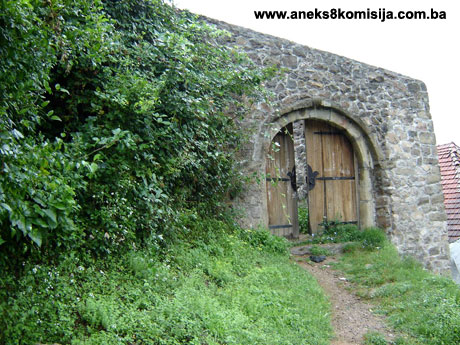
The last works to be carried out on the Old Maglaj Fort date from the 18th century, since when there have been no changes inside the fort. Although it underwent several tages of building and various alterations, to a large extent the the mediaeval core was preserved. The fort consists of a central part and two baileys added later, one on the northern upper plateau with a clock tower (12), and the othere running along the north-western and western part of the fort. Access to the fort is along an old mediaeval road (present-day Tvrđavska [Fortress] street) from the south, from the Zagrađe mahala. The main entrance is at the north-eastern corner of nthe fort, and leads into a long, narrow ward (11), leading in turn to the bailey (12) with the clock tower (1). A little to the south of the entrance to the bailey from the ward is another to the gatehouse tower (4), entered via a staircase. A staircase also leads from the gatehouse tower to the courtyard of the original mediaeval part of the fort. The upper plateau of the fort (the courtyard) is about 6 m higher than the bailey and wards built in the 18th century.
The mediaeval part of the fort
The mediaeval part of the fort is the central area on the highest point of the rocky outcrop. The mediaeval fortress was built in stages, probably beginning with the keep or guard tower (9), then the south tower (3) with the ward and palace. The narrow courtyard, where there was a cistern to the south-east, was surrounded by ramparts. The entrance was where the gatehouse tower (4) was later built. Though archaeological excavations produced no convincing evidence, the assumption is that there was a county fort on the same site in the 13th and 14th centuries. This assumption is based on the position of the Maglaj fort and on archaeological material from the deepest stratum in the probe and the western part of the fort. Quantities of pottery shards and animal bones were found in a dark cultural layer at a depth of 2 m (Bojanovski, 1965, 68, 83).
The keep or guard tower (9), the fort’s main tower, forms part of the eastern rampart, on the highest point of the outcrop, where it was most readily accessible and open to attack. It also stands opposite the gatehouse tower (4), which protected it. Although it now looks like a tabija (bastion), adapted to later conditions of warfare, its position and the findings of archaeological investigations reveal that it was a mediaeval guard tower. The walls are 3 m thick in the foundations, and narrow towards the top, giving it a shape that helps bullets to ricochet off it. The foundation walls and the revetment of the mediaeval tower up to first-floor level were retained. Inside, the bottom level was divided into two by a wall, with the larger area forming a dungeon the entry to which was through a hatch in the wooden ceiling. The dungeon was lit by a small window on the courtyard side. The entrance to the tower was at first-floor level. The tower presumably had three storeys. Larger cannon holes (with a height of 0.6 m, and a width on the outside of 0.45 m and on the inside of 1.70 m) constituted a new defence feature. At first-floor level on the outside east wall of the tower, providing an effective defence for the easiest point of access to the fort. In the Ottoman period the tower was converted into a bastion; the upper storeys were demolished down to first-floor level, and the inside of the tower was filled in and turned into a cannon emplacement.
There was a small semicircular flanking tower at the southern corner, the south tower (3), with a slightly polygonal form on the outside. The lower parts of the tower are of mediaeval construction; the upper parts were later somewhat remodelled. There was an inner courtyard in front of the tower, in which the remains of a small residential building (a palace?) were found; this was later demolished when a casement was built. There were steps against part of the west rampart, by the south tower (Bojanovski, 1965, 71-72). The north rampart (by which tower (2) was later built) is zigzag in plan, an adaptation designed to protect the fort from artillery fire. The north-eastern part of the courtyard, by the east rampart, contained a cistern dug into the living rock, and built of tufa set in a thick layer of clay. Similar cisterns have been found in the forts at Vranduk, Doboj and Bobovac.
The entrance (4) to the mediaeval fort was on the steep west side, with a road leading up to it from the south, from Zagrađe. The appearance of the mediaeval gatehouse tower is not known, but the doorway was probably set high in the ramparts. Archaeological investigations revealed that the entrance was protected on the outside by a barrier (Bojanovski, 1965, 72).
In its polygonal plan and style of masonry, the upper fort is in the tradition of military defensive architecture of the late 14th or early 15th century. Its main components were the substantial keep or guard tower (7), the south tower (3), with its inner courtyard and residential building, and the construction of the ramparts with transverse tie beams. At that time, 1398 to 1408, King Sigismund of Hungary fought four wars in Bosnia, and the Usora area – the river Bosna valley, which was the entry point to this territory – was first to come under attack (Bojanovski, 1965, 69-70). This has been corroborated by finds of mediaeval movable artefacts.
Numerous shards of mediaeval pottery have been found in various places in the upper fort, many in strata at a depth of one to two metres. Six helmets of Kesselhaube type, dating from the 14th century (one of which was so badly rusted that it had disintegrated), were found in the earthwork in the corner formed by the east wall of the gatehouse tower and the drywall retaining wall (position a on the plan), at a depth of 2.2 m. An iron vessel with 2 kg of carbonized wheat and shards of coarse grey late mediaeval pottery was found with the helmets (Bojanovski, 1965, 73-74).
An artillery piece known as a bombarda was found below the large loophole in the west wall of the gatehouse tower (position b on the plan), at a depth of 1.5 m in the earthwork, with two stone cannonballs beside it, one of 0.9 m diameter (matching the calibre of the artillery piece) and the other of 1.2 m. The artillery piece was made of cast iron and has a shorter kauba or chamber (the narrower rear part of the cannon) than earlier cannons, which were made of wrought iron rings. These typological features date it to the early 15th century (Bojanovski, 1965, 75-76). Other weaponry found consisted of two veretons (crossbow bolts). A large number of smaller-calibre stone cannonballs were excavated – 150, 120, 100, 90, 85 and 80 mm – and about 80 pieces of iron cannonballs, also of smaller calibre, 100 to 55 mm.
Ottoman-period artillery fortress
The fort in Maglaj came under Ottoman rule in 1476. Although major construction works were carried out as early as 1490, it was not until the 17th century that the fort was converted into an artillery fort, in response to the need to modernize the old forts, especially those located on major roads. The Turkish-Austrian wars began in the latter half of the 17th century, from 1663 on.
Further evidence for the fact that the mediaeval fort was converted into an artillery fort in the 17th century is provided by the discovery of part of a cannon in the courtyard earthwork. The cannon was dated to the 16th century, meaning that the level of the courtyard was raised in the following century (Bojanovski, 1965, 78).
It is not known exactly when in the 17th century the first adaptation was carried out. The guard tower (9) was demolished down to first-floor level and converted into a smaller corner bastion of hexagonal plan with a diameter of 10 m on the outside and walls 2-3 m thick. The east rampart, against which the bastion abuts, was lowered, and the original west rampart was demolished. The stone was used to built five metres of substantial retaining wall further to the west. The courtyard of the upper part of the fort was thus enlarged by 5 m, to a width of 20 m. An irregular pentagonal bastion (2) with walls 2-3 m thick was built in the north corner, at the most exposed point of the courtyard. Since a new entrance gateway had been opened up in the north wall, yet another irregular rectangular tower (5) was built by bastion 2, by the inner north-eastern corner of the courtyard; the walls of this tower are 2-3 m thick on the outside and up to 1 m thick on the inside. The entrance to the fort (4) was also somewhat remodelled. The structures built or converted in this adaptation have horizontal wooden tie beams running the length of the wall. Later, such tie beams were no longer used to brace and stabilize the walls, which makes it possible to distinguish the two stages of adaptation of the Maglaj fort. In the first stage, the fort was adapted to house cannon and for defence against artillery fire, with towers 3, 4 and 5 still used for defence by gunfire. The later adaptation was in the late 17th century, between 1683 and 1699, when three substantial casemates were built (6, 7 and 8), outside which 150 manguras (copper coins) minted in Sarajevo in 1690 were found. The gatehouse tower (4) acquired its final form with the addition of a barrel vault. It was probably at that time that the walkway by the east rampart was laid. A 1697 engraving shows that the fort still had neither bailey (12) nor the ward or zwinger (11), and that it was surrounded by a palisade. The clock tower had already been built. On 7 October 1697 the Maglaj garrison surrendered the fort to Eugene of Savoy's troops without a fight. Two hundred prisoners were taken, and the meagre booty consisted of just three small cannon and one mortar. As they withdrew from Bosnia in late October that year the Austrians blew up the Maglaj fort, though the scale of the destruction is not known.
In the 18th century the later outer parts of the fort became the front line of defence (Popović, 1995, 38-39). A bailey about 30 m long and with an average width of about 20 m (12) was bult by the northern part of the fort. An outer wall with loopholes was built on the west and north side, thus forming a narrow ward 110 m long and 7 to 11 m wide, passable only along a 3-4 m wide path, the rest of the site being steep or banked up with earth against the walls (11). The simple main gateway in the ramparts, at the north-eastern corner of the ward, was also built at that time, and the east rampart and south tower were repaired.
The fort remained essentially unchanged as a castle by subsequent repairs in the 18th century. In a military description from 1765 the fort is described as not large, and as having medium and small calibre cannon (Bodenstein, 1908, 97). In 1785, before the last Austro-Turkish war (the 1788 -1791 Dubica war), Major Božić provided a description of the fort as having walls about 14 feet high (a little over 4 m), with one round and three polygonal towers, only one of which had cannon. The dizdar or fortress commander lived in one of the towers (Bojanovski 1965, 81, n. 75). The north tower (2) is still known as the captain’s tower.
The clock tower was erected in the north bailey of the old fort. The walls are stone and the roof is clad with sheet metal. The walls were rendered with stale slaked lime, which has fallen away from the east and west wall. Standing as it does on a rocky base, the south side of the clock tower is shorter than the north. The tower is square in plan, with sides of 3.07 m. The north or front face is 17.1 m high, and the south face 14.77 m high. The two sections of the bipartite four-paned, pitched polygonal roof are separated by a slatted wooden structure, with slats like those once fitted into the upper openings. The bell hung from the upper section of the roof. The south wall has a narrow rectangular doorway from which the door itself is missing; all that remains is part of the wooden door jamb. The tower was poorly lit by small slit-like openings in the south wall above the doorway, at two levels, and the north wall, at three levels. There are larger, arched openings below the roof on all four sides; in 1955 these still had their narrow vertical slats, but these have now disappeared. After 1878 a clock mechanism was ordered in Vienna for the clock tower. Vasva-hanuma, who married Mustaj-beg Uzeirbegović in Maglaj in 1896, specified in her will that a bell should be bought; it was duly purchased at a trade fair in Zagreb in 1923.
In 1955, Kreševljaković found that the tower was well preserved, and kept Central European time. The tower is now neglected and dilapidated, and lacks its clock and bell (Kreševljaković, 1957, 31).
Artefacts dating from the Ottoman period were found in shallow strata. In addition to shards of green-glazed and ordinary, coarse pottery, a cannon dating to the 16th century was found with iron cannon balls. A hoard of 150 copper manguras (coins), minted in Sarajevo in 1690, was found outside the large casemate.
The pottery found during the excavations carried out in 1962-1963 is housed in the National Museum. The other finds (5 helmets, the bombarda, cannon, manguras) cannot be tracked down at present.
3. Legal status to date
In the procedure prior to the adoption of the final decision on designation, the documents on the protection of the property were inspected. The findings are as follows:
Pursuant to the law and by Ruling of the National Institute for the Protection of Cultural Monuments of NRBiH no. 1299/50, dated 28 Ocotber 1950, the Old Maglaj Fort, Maglaj Municipality, was placed under state protection.
By Ruling no. 02-720-3, dated 18 April 1962, it was entered in the Register of immovable cultural heritage.
The architectural ensemble of the Old Maglaj Fort is on the Provisional List of National Monuments under the heading Maglaj – Old Fort, under serial no. 366.
The Regional Plan for BiH to 2000 lists the property as a Category II monument.
4. Research and conservation and restoration works
Minor repairs were carried out during the Austro-Hungarian period.
In 1953 and 1954, minor conservation works were carried out on the south tower (3) and the walls around the main gatehouse (4).
In 1962 and 1963 extensive archaeological investigations were carried out to obtain information for conservation and restoration works. The conservation of the ramparts, bastions and in part of the casemates and cistern in the fort (with the exception of the clock tower) was carried out in line with two projects, the first drawn up by architects Esad Kapetanović and Nedeljko Rosić, and the second by Dr. Ivo Bojanovski, engineer Enver Dedić, architect Remzija Korkut and building technician Enver Šešić.
In 2000, experts from the Heritage Centre of the Institute for the Protection of the Cultural, Historical and Natural Heritage of Bosnia and Herzegovina of Sarajevo drew up a project for the repair, conservation and restoration of the Old Maglaj Fort. The project has not yet been implemented.
5. Current condition of the property
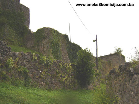
The findings from an on-site inspection of the Old Maglaj Fort conducted on 4 August 2005 are as follows: more than forty years have elapsed since the last restoration and conservation works, during which time the Maglaj fort has become quite dilapidated, with damage caused by vegetation and by mortar crumbling and being washed out, particularly on the crown of the ramparts. There was no direct war damage during the 1992-1995 war. Much of the damage has been caused by self-sown vegetation. Quantities of stone are scattered around inside the fort, most of it fallen away from the crown of the walls, and in places large areas of the wall revetment has also fallen away. The wooden roof of the gatehouse tower, which was replaced in 1962-1963, has fallen in, as has almost all the arched entrance to the north bailey (which was already recorded as having been destroyed by force some twenty years ago). The steps in the south-west corner of the courtyard have been almost completely destroyed. In the 1980s all the stairways inside the fort, of which there are four including those at the south-west corner, were also found to have collapsed or been demolished, and the walkways within the ramparts were in a state of neglect. This remained the case in 2005. Some features, such as the cistern and the keep (9) and casemates (6, 7) were found to be in a state of complete neglect. There is a risk of stones falling from the crown of the ramparts, which poses an immediate danger to the residents in the neighbourhood.
The entrance to the fort is open at all times and visits are unchecked. Houses are cropping up almost against the very ramparts, and even in the 1980s it was noted that buildings were being erected without permission around the fort (details from the project of the Heritage Centre of the Institute for the Protection of the Cultural, Historical and Natural Heritage of Bosnia and Herzegovina, Sarajevo, drawn up in 2000, Section 2.2. Projected development of the built heritage in the Maglaj commune region, 47-48).
The clock tower has a sound sheet metal roof cladding, but the rendering has fallen away from much of the walls. Half the door jamb remains, but the door is missing.
6. Specific risks
- lack of maintenance,
- self-sown vegetation.
III - CONCLUSION
Applying the Criteria for the adoption of a decision on proclaiming an item of property a national monument (Official Gazette of BiH nos. 33/02 and 15/03), the Commission has enacted the Decision cited above.
The Decision is based on the following criteria:
A. Time frame
B. Historical value
D. Clarity (documentary, scientific and educational value)
D.i. evidence of historical change
D.iv. evidence of a particular type, style or regional manner
F. Townscape/ Landscape value
F.ii. meaning in the townscape
F.iii. the building or group of buildings is a part of a group or site
G. Authenticity
G.v. location and setting
H. Rarity and representativity
H.i. unique or rare example of a certain type or style
The following documents form an integral part of this Decision:
- Copy of cadastral plan;
- Ruling of the Institute for the Protection of Culture of SR BIH, dated 18 April 1962, on entering the Old Town of Maglaj in the Register of Protected Cultural Monuments;
- Materials from Maglaj Municipality – information on the cultural and historical monuments of the town of Maglaj. The materials include The Old Maglaj Fort, Project for Repair and Conservation and Restoration Works, Heritage Centre of the Institute for the Protection of Cultural, Historical and Natural Heritage of Bosnia and Herzegovina, Sarajevo 2000;
- Photo documentation:
- illustrations from various publications,
- photographs taken during the on-site inspection in May 2005;
- Drawings.
Bibliography
During the procedure to designate the monument as a national monument of BiH, the following works were consulted:
1904. Truhelka, Ćiro, Naši gradovi, opis najljepših sredovječnih gradova Bosne i Hercegovine (Our Forts, Description of the Most Beautiful Mediaeval Forts of Bosnia and Herzegovina), Sarajevo, 1904.
1908. Bodenstein, Gustav, “Povijest naselja u Posavini god 1718-1739” (The History of Settlements in Posavina, 1718 – 1739), Journal of the National Museum in Bosnia and Herzegovina, XX, Sarajevo, 1908, 95 –112.(1)
1951. Jireček, Josip, Trgovački drumovi i rudnici Srbije i Bosne u srednjem vijeku (Commercial Roads and Mines of Serbia and Bosnia in the Middle Ages), Svjetlost, Sarajevo, 1951.
1952. Kreševljaković, Hamdija, Prilozi povijesti bosanskih gradova pod turskom vladavinom. (Contributions to the History of Bosnian Towns under Turkish Rule), Prilozi za orijentalnu filologiju i istoriju jugoslovenskih naroda pod turskom vladavinom, II/1951 (Contributions to Oriental Philology and the History of the Peoples of Yugoslavia under Turkish Rule, Sarajevo, II /1951), Sarajevo, 1952, 119 -184.
1953. Kreševljaković, Hamdija, “Stari bosanski gradovi”, Naše starine, I (Old Bosnian Towns, Our Antiquities I), Sarajevo, 1953, 7- 45.
1957. Kreševljaković, Hamdija, “Sahat kule u Bosni i Hercegovini”, Naše starine, IV (Clock Towers in Bosnia and Herzegovina, Our Antiquities IV), Sarajevo, 1957, 17-32.
1964. Ćirković, Sima, Istorija srednjovjekovne bosanske države (The History of the Mediaeval Bosnian State), Belgrade, 1964.
1965. Bojanovski Ivo, “Istraživački i konzervatorski radovi na starom Maglaju 1962- 1963 g.”, Naše starine, X (Research and Conservation Works on Old Maglaj 1962-1963, Our Antiquities X), Sarajevo, 1965, 61-99.
1975. Handžić, Adem, Tuzla i njena okolina u XVI vijeku (Tuzla and its Surroundings in the 16th century), Svjetlost, Sarajevo, 1975.
1977. Anđelić, Pavao, “O usorskim vojvodama i političkom statusu Usore u srednjem vijeku” (On the Dukes and Political Status of Usora in the Middle Ages), Prilozi Instituta za istoriju u Sarajevu, br.13, godina XIII, Sarajevo, 1977, 17-45. (Contributions of the Institute of History in Sarajevo, no. 13, year XIII, Sarajevo, 1977, 17-45).
1978. Kovačević-Kojić, Desanka, Gradska naselja srednjovjekovne bosanske države (Urban Settlements of the Mediaeval Bosnian State), IP Veselin Masleša, Sarajevo, 1978.
1982. Šabanović, Hazim, Bosanski pašaluk (The Bosnian Pashaluk), Svjetlost, Sarajevo, 1982.
1991. Kreševljaković, Hamdija, “Kapetanije u Bosni i Hercegovini” (Captaincies in Bosnia and Herzegovina), In: Selected Works, I, Veselin Masleša, Sarajevo, 1991.
1991. Handžić, Adem, “O kretanju stanovništva u regionu srednjeg toka Bosne (međuprostor Maglaj-Doboj-Tešanj) od druge polovine XV do kraja XVI vijeka” (On Population Movements in the Region around the Central Course of the Bosna (between Maglaj, Doboj and Tešanj) from the Second Half of the 15th Century to the End of the 16th Century), In: Studije o Bosni historijski prilozi iz osmansko-turskog perioda (Studies on Bosnia – historical contributions from the Ottoman-Turkish Period), Publ. Organisation of the Islamic Conference and Research Centre for Islamic History, Art and Culture, Istanbul, 1994, 15-22.
1995. Popović, Marko, “Srednjovekovne tvrđave u Bosni i Hercegovini-prilog proučavanju fortifikacionih struktura” (Mediaeval fortresses in Bosnia and Herzegovina – a contribution to the study of fortification structures) Zbornik za istoriju Bosne i Hercegovine, 1 (Collected papers: History of Bosnia and Herzegovina 1), Serbian Academy of Sciences and Arts, Belgrade, 1991, 33-54.
(1) Bodenstein's report printed around 1787 (Kreševljaković, 1991, 29, n. 23).
|