Status of monument -> National monument
Pursuant to Article, V Para. 4, Annex 8 of the General Framework Agreement for Peace in Bosnia and Herzegovina and Article 39, Para. 1 of the Rules of Procedure of the Commission to Preserve National Monuments, at a session held from 30 August to 4 September 2005 the Commission adopted a
D E C I S I O N
I
The historic monument of the stećak tombstones in Banovići Selo (the village of Banovići) near Banovići is hereby designated as a National Monument of Bosnia and Herzegovina (hereinafter: the National Monument).
The National Monument consists of two stećak tombstones.
The National Monument is located on cadastral plot no. 1370, Land Register entry no. 151, cadastral municipality of Banovići Selo, Banovići Municipality, Federation of Bosnia and Herzegovina, Bosnia and Herzegovina.
The provisions relating to protection measures set forth by the Law on the Implementation of the Decisions of the Commission to Preserve National Monuments, established pursuant to Annex 8 of the General Framework Agreement for Peace in Bosnia and Herzegovina (Official Gazette of the Federation of Bosnia and Herzegovina nos. 2/02 and 27/02), shall apply to the National Monument.
II
The Government of the Federation of Bosnia and Herzegovina (hereinafter: the Government of the Federation) shall be responsible for providing the legal, scientific, technical, administrative and financial measures necessary to protect, conserve and display the National Monument.
The Commission to Preserve National Monuments (hereinafter: the Commission) shall determine the technical requirements and provide funds for preparing and setting up signboards with the basic data on the monument and the Decision to proclaim the property a National Monument.
III
To ensure the on-going protection of the National Monument, the following measures shall apply to the area defined in Clause I, para. 3. of this Decision.
- all works are prohibited other than research and conservation and restoration works, routine maintenance works, and works designed to present the monument, with the approval of the Federation Ministry responsible for regional planning (hereinafter: the relevant ministry) and under the expert supervision of the heritage protection authority of the Federation of Bosnia and Herzegovina (hereinafter: the heritage protection authority),
- the site of the monument shall be open and accessible to the public, and may be used for educational and cultural purposes,
- no new burials shall be permitted at a distance of less than 5 metres from the stećak tombstones,
- the dumping of waste is prohibited.
Disposal of waste is not permitted.
The Government of the Federation shall be responsible in particular for implementing the following protection measures:
- making good the access road
- repairing the damaged stećak tombstones
- repairing the fence
- drawing up and implementing a programme for the presentation of the National Monument
IV
All executive and regional development planning acts not in accordance with the provisions of this Decision are hereby revoked.
V
Everyone, and in particular the competent authorities of the Federation of Bosnia and Herzegovina, the Canton, and the city and municipal authorities, shall refrain from any action that might damage the National Monument or jeopardize the preservation thereof.
VI
The Government of the Federation, the Federation Ministry responsible for regional planning, the Federation heritage protection authority and the municipal authority in charge of urban planning and land registry affairs, shall be notified of this Decision in order to carry out the measures stipulated in Articles II to V of this Decision, and the authorized Municipal Court shall be notified for the purposes of registration in the Land Register.
VII
The elucidation and accompanying documentation form an integral part of this Decision, which may be viewed by interested parties on the premises or by accessing the website of the Commission (http://www.aneks8komisija.com.ba).
VIII
On the date of adoption of this Decision, the National Monument shall be deleted from the Provisional List of National Monuments of Bosnia and Herzegovina (Official Gazette of BiH no. 33/02, Official Gazette of Republika Srpska no. 79/02, Official Gazette of the Federation of BiH no. 59/02, and Official Gazette of Brčko District BiH no. 4/03), where it featured under serial no. 1.
IX
Pursuant to Article V, Para. 4, Annex 8 of the General Framework Agreement for Peace in Bosnia and Herzegovina, decisions of the Commission are final.
XI
This Decision shall enter into force on the date of its adoption and shall be published in the Official Gazette of BiH.
This Decision has been adopted by the following members of the Commission: Zeynep Ahunbay, Amra Hadžimuhamedović, Dubravko Lovrenović, Ljiljana Ševo and Tina Wik.
No: 05.1-02-204/05-4
2 September 2005
Sarajevo
Chair of the Commission
Ljiljana Ševo
E l u c i d a t i o n
I – INTRODUCTION
Pursuant to the Law on the Implementation of the Decisions of the Commission to Preserve National Monuments, established pursuant to Article 2, Para. 1 of Annex 8 of the General Framework Agreement for Peace in Bosnia and Herzegovina, a “National Monument” is an item of public property proclaimed by the Commission to Preserve National Monuments to be a National Monument, pursuant to Articles V and VI of Annex 8 of the General Framework Agreement for Peace in Bosnia and Herzegovina, as well as the property entered on the Provisional List of National Monuments of Bosnia and Herzegovina (Official Gazette of BiH no. 33/02) until the Commission reaches the final decision on its status, as to which there is no time limit and regardless of whether a request for the property in question has been submitted or not.
The Commission to Preserve National Monuments adopted a Decision to add the historic monument of the Banovići Stećak to the Provisional List of National Monuments of Bosnia and Herzegovina under serial number 1.
Pursuant to the provisions of the law, the Commission proceeded to carry out the procedure for reaching a final decision to designate the property as a national monument, pursuant to Article V of Annex 8 and Article 35 of the Rules of Procedure of the Commission to Preserve National Monuments.
II – PROCEDURE PRIOR TO DECISION
In the procedure preceding the adoption of the final decision to proclaim the property a national monument, the following documentation was inspected:
- Documentation on the location and current owner and user of the property (copy of cadastral plan and land registry entry),
- Data on the current condition and use of the property, including a description and photographs, data on war damage, data on restoration or other works on the property, etc.,
- Historical, architectural and other documentary material on the property.
The findings based on the review of the above documentation and on the condition of the property are as follows:
1. Information on the property
Location
The town of Banovići is located on the north-western slopes of Mt. Konjuh, 330-380 metres above sea-level, on the main road connecting two major industrial centres, Tuzla and Zenica, and two large cantons, Tuzla Canton and Zenica-Doboj Canton. It lies 36 km from Tuzla and 110 km from Sarajevo.
The municipality comprises the river basins of the Krivaja and Spreča and is oriented by the valleys of the Litva and Turija. The entire area is characterized by slopes towards the north and in part towards the east.
In Banovići Selo, 12 km west of the town, next to a modern Muslim graveyard and the memorial to the fallen soldiers of World War II, there are two tombstones dating from mediaeval times. The town was named after one of them, the stećak of Božićko Banović.
The stećaks were transferred here from their original location as a result of the exploitation of the Banovići brown coal mine.
Historical information
From the mid-14th century the basin of the Spreča River – Sol and central Podrinje (the Drina basin area) with the river basin of Drinjača, territories that until that time were organised as separate territorial and political units (P. Anđelić, 1977, 18), were considered as parts of the mediaeval district of Usora(1). The land or district of Sol was probably divided into several župas (counties) in early feudaltimes. The old name of Sol has been preserved only in the name of Tuzla, and the Spreča River basin, as a geographical unit, is known by the name of Spreča, and is still divided into the Upper, Middle and Lower Spreča River in the minds of the people.
Pavao Anđelić assumes that the district of Sol was divided into three counties in the early feudal county structure. One of them, the Upper Spreča county, comprised the upper basin of the Spreča River and included the following territories of the district, later called nahija (Turkish administrative district): Spreča, Gostilje and Dramešine (with present day Banovići). The second county extended along the basin of the small river of Jala and the middle course of Spreča, comprising the Sol county and later also the nahijas of Donja and Gornja Tuzla, Smoluća and in part Dramešin. The third county occupied the lower course of the Spreča, which later coincided with the nahija of Sokol. (P. Anđelić, 1977, 27.) (2)
The earliest written source referringn to the land of Usora with Sol as belonging to the Bosnian State was a deed of gift by the Bosnian ban Stjepan Kotromanić (1322-1353), dating from 1322, which makes mention of gospodin vsem zemljam bosanskim i Soli i Usore... (Ruler of all lands of Bosnia and of Sol and Usora…). During Stjepan’s reign, Sol was finally integrated with Usora.
Written sources mention two names of the landowners of Sol: district prefect Budoš (referredto in two charters of ban Stjepan II, dating from 1326 -1329) and headman Hlap (in a charter dating from 1326-1329).
There is reference to the Hungarians penetrating as far as Usora and Sol during the reign of King Dabiša in 1394, when the town of Dobor was burnt down. In 1405, during the reign of Tvrtko II the Hungarians, led by the ban of Mačva, Ivan Morović, penetrated to Usora again and seized Srebrenik, and in 1408 other towns as well. Srebrenik and much of Usora were ruled by the Hungarians until 1442/43.
Usora and Sol feature in the titles of the Bosnian rulers until the fall of the Bosnian State. The parish of Dramešin(a), which belonged to the district of Sol, is mentioned in the inscription on the stećak of Božićko Banović in Banovići Selo. The stećak can be approximately dated to the second half of the 14th century (M. Vego, 1970, 60).
2. Description of the property
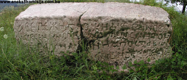
The stećak tombstones are located in the far western part of the elevation.
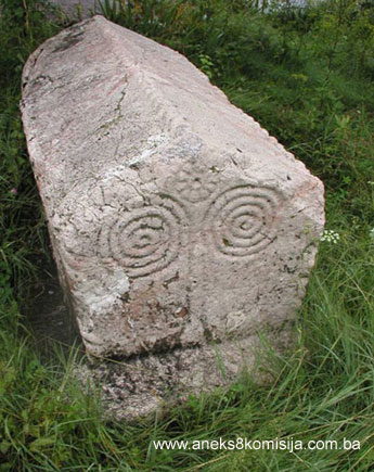
In shape "the stećak of Božićko Banović" is ridged (gabled), with a pedestal. The pedestal measures 2.20 x 1.00 x 0.20 m, and the ridge 1.81 x 0.75 x 0.67 m. It is of good workmanship, and lies west-east. It is decorated and bears an epitaph. The ornamental motifs are a twisted ribbon along the edges and a double spiral with a rosette on the east-facing front end. The side has the following five line epitaph in Bosnian Cyrillic:
Transcription:

Entire transcription:

Here lies Božićko Banović, on his noble land and on Dramešina, and the stećak has been erected by Hlapac and I Bogdan and I Rajko with brothers. (M. Vego, 1970, 61.).
The inscription is well preserved and legible. This is to date the oldest mediaeval source referring the county of Dramešina.
The second stećak is two metres away from the first. It is also ridge-shaped, with a smaller pedestal, measuring 1.70 x 0.65 x 0.17 m. The ridge measures 1.50 x 0.52 x 0.37 m. The ornamental motifs are identical – a twisted ribbon along the edges and double spirals with rosettes on both ends. There are no ornaments on the sides. The north side of the stećak is damaged.
3. Legal status to date
The historic monument of the stećak in Banovići is on the Provisional List of National Monuments under the name Banovići-Stećak and serial number 1.
In the Regional Plan for BiH to 2000, it is listed as a Category III monument.
4. Research and conservation and restoration works
There is no information as to conservation and restoration works to date.
5. Current condition of the property
On the basis of an on-site inspection, carried out in August 2005, the following has been ascertained:
Access to stećaks has not been arranged. Both stećaks are overgrown with grass and high vegetation. They are both damaged. The stećak of Božićko Banović is split and requires urgent conservation and restoration. Traces of unprofessional interventions are observable on the east end. The epitaph is covered with moss.
6. Specific risks to which the monument is exposed:
There are no specific risks.
III - CONCLUSION
Applying the Criteria for the adoption of a decision on proclaiming an item of property a national monument (Official Gazette of BiH nos. 33/02 and 15/03), the Commission has enacted the Decision cited above.
The Decision is based on the following criteria:
A) Time frame
B) Historical value
C) Artistic and aesthetic value
C. iv. composition
C. v. value of details
D) Clarity (documentary, scientific and educational value)
D.ii. evidence of historical change
G) Authenticity
G.i. form and design
G.ii. material and content
H) Rarity and representativity
H.i. unique or rare example of a certain type or style
The following documents form an integral part of this Decision:
- Copy of cadastral plan,
- Photo documentation from the site, 17 August 2005,
- Drawings.
Bibliography
During the procedure to designate the property as a national monument of Bosnia and Herzegovina the following works were consulted:
1970. Vego, Marko, Zbornik srednjovjekovnih natpisa Bosne i Hercegovine (Collection of Mediaeval Inscriptions of Bosnia and Herzegovina), Book IV, Sarajevo, 1970, 60-61.
1971. Bešlagić, Šefik, Stećci, kataloško-topografski pregled (Stećak Tombstones, Catalogue and Topographical Overview), Sarajevo, 1971, 142-143.
1975. Handžić, Adem, Tuzla i njena okolina u XVI vijeku (Tuzla and its Surroundings in the 16th Century), Sarajevo 1975.
1977. Anđelić, Pavao, O usorskim vojvodama i političkom statusu Usore u srednjem vijeku (On Usora Dukes and Political Status of Usora in Mediaeval Times), Prilozi instituta za istoriju u Sarajevu (poseban otisak iz br. 13. god. XIII) (Contributions of the Institute for History in Sarajevo (special offprint from no. 13, year XIII), Sarajevo 1977,17-45.
1982. Vego, Marko, Postanak srednjovjekovne bosanske države (Origin of Mediaeval Bosnian State), Sarajevo, 1982, 51-54.
1982. Bešlagić, Šefik, Stećci-kultura i umjetnost (Stećci-Culture and Art), Sarajevo, 1982, 49-50,116.
(1) Various forms appeared during the 13th century in written sources in Latin of the offices of Rome and Hungary: Wosora (1225), Wassora (1225), Wascura (1236), Wozora (1244) and Vozora (1273). Domestic written sources make no mention of Usora until 1326, when it was mentioned in very clear form as Ussora. The earliest written information on Usora, dating from the 13th century, suggests that this district reached as far as the Drina River. Its northern boundary was invariably the Sava River, and the western the rivers of Bosna and Ukrina. (P. Anđelić, 1977, 18).
(2) For comparison purposes P. Anđelić uses the map of Turkish nahijas from the book "Tuzla and its surroundings in the 16th century" by A. Handžić.
|